

This study aims to investigate how community-based natural resource management (CBNRM) principles can inform the stewardship and management of urban green infrastructure, using the Segoditshane River Corridor (SRC) in Gaborone, Botswana, as a case study. It examines the current functional state of the SRC, identifies key success factors for community-led facilities management and proposes management strategies to enhance community stewardship and utility of the corridor as a public and community facility.
A qualitative case study design was adopted, integrating multiple data sources: semi-structured interviews with government officials, a structured community questionnaire survey of 29 residents, non-participant observation and document review. Data were analysed using thematic and qualitative content analysis to integrate perspectives across stakeholders and contextualise findings within CBNRM and urban facility management frameworks.
The SRC is currently underutilised, environmentally degraded and subject to safety concerns. Governance gaps and limited community engagement constrain its optimal functional utility. Key success factors for community-based management include inclusive participation, local ownership and coordinated institutional support. Residents expressed interest in multifunctional land uses such as recreational spaces, urban agriculture and community-managed facilities, suggesting strong potential for community stewardship – when involved in the management of the community’s green facility.
This study is based on a single qualitative case study of the SRC, which enables in-depth contextual analysis but limits the generalisability of findings beyond similar urban contexts. The community sample was relatively small (29 respondents) and selected through convenience sampling, which may not fully represent the diversity of perspectives across Gaborone. Data were collected at one point in time and therefore do not capture seasonal or longitudinal changes in river conditions, land use practices or community engagement. In addition, much of the evidence is derived from self-reported perceptions and researcher observations, which may be subject to response and interpretation bias despite triangulation. Finally, the proposed stewardship and land-use strategies were not empirically tested.
By incorporating resident preferences, demographic realities and existing ecological assets, urban planners and municipal authorities can design interventions that simultaneously enhance recreation, livelihoods and environmental quality. Examples include urban agriculture plots for women, recreational facilities for youth, pedestrian trails and event hosting centres. These interventions can create local employment opportunities, strengthen social cohesion, improve the maintenance and security of public open spaces. The study underscores that CBNRM-informed management is not only socially inclusive but also economically and environmentally sustainable, offering a practical framework for municipalities facing resource constraints.
This study extends the application of CBNRM beyond rural contexts into urban green infrastructure and facilities management, demonstrating the potential for community-based stewardship to enhance social, ecological and economic outcomes. It provides empirically grounded insights relevant to researchers, practitioners and policymakers working to improve urban natural resource governance.
Introduction
In recent decades, the theory and practice of natural resource management have undergone a significant paradigm shift, moving from centralised state control towards participatory models that empower local citizenry (Wood, 2008). While environmental management was traditionally the purview of national governments, there is increasing recognition that local communities residing near a resource are its most effective stewards as they are the major interested and affected parties. One manifestation of this concept is community-based natural resource management (CBNRM), an approach that encourages communities to take a leadership role in the planning and management of their surrounding environments Rinaldi (2007), Roka (2019). Although historically rooted in rural conservation (with notable Southern African examples such as Communal Areas Management Programme for Indigenous Resources (CAMPFIRE) in Zimbabwe and Living in a Finite Environment (LIFE) in Namibia (Ngwira, Kolawole and Mbaiwa, 2013); the evolution of the built environment necessitates a translation of these principles into the urban landscape.
In the context of the modern city, urban natural assets (such as river corridors, wetlands and forests) should no longer be viewed merely through the lens of ecology, and treated in isolation of the built environment. Instead, they represent critical Green Infrastructure and Community Facilities that provide essential services to the urban citizenry. In the built environment, these corridors function as “community’s lungs” and “open-air facilities”, providing ecosystem services such as storm-water regulation, heatwave mitigation and recreational utility essential for urban liveability. However, managing these ‘natural urban facilities’ in rapidly growing African cities like Gaborone, Botswana, presents a unique challenge for facilities managers and urban planners. Unlike “grey infrastructure” (roads and buildings), these green assets often fall into neglect and become sites of pollution and crime due to a lack of formal maintenance structures and community detachment.
The adoption of CBNRM in urban areas addresses this management gap by reframing natural resources as shared community assets. In urban settings, residents often feel disconnected from decision-making processes regarding local environmental management. By applying a stewardship model, these “disconnected” spaces are integrated back into the urban fabric, transforming them from liabilities into high-performing facilities. This approach fosters resilience against climate change impacts, such as flooding and the urban heat island effect, by empowering communities to create adaptive, localised maintenance strategies. As highlighted by World Neighbours (2022), this people-cantered approach integrates the conservation of the resource base with urban development goals, aiming to overcome social challenges through active community engagement.
This study examines the key success factors for a stewardship-based management model within the Segoditshane River Corridor (SRC) in Gaborone, Botswana. It seeks to bridge the gap between natural resource management and urban facilities management by answering the following research questions:
What is the current functional state of the natural resources and facilities along the Segoditshane River Corridor?
Which key success factors can promote a community-led facilities management approach within the Segoditshane River belt?
What management strategies can be implemented to enhance community-based stewardship and improve the utility of the Segoditshane River corridor as a public facility?
Literature review
The evolution of urban facility management
Traditionally, the discipline of facilities management (FM) was narrowly confined to the technical maintenance and operational efficiency of “grey” infrastructure and individual built assets (Tansar et al., 2023). Under this conventional paradigm, success was measured through cost-reduction and the physical longevity of buildings. However, a significant shift occurred in the early 2000s, catalysed by a growing mandate for sustainable urban development and a “people-centered” approach to the management of the built environment (Kuijlenburg, 2020).
Central to this evolution was the emergence of community-based facilities management (CBFM). Alexander and Brown (2006) defined CBFM as the management approach in which the planning, operation and delivery of facilities and services are organised around the needs, participation and resources of a local community rather than only around a single organisation or landlord. Alexander and Brown (2006) posited that, the profession must transcend purely technical operations to prioritise “social profit” – the collective well-being and empowerment a facility provides to its citizenry. Building on this, Temeljotov Salaj and Lindkvist (2021) formally define urban facility management (UFM) as an integrated framework that moves beyond the building to manage the “urban scale”, focusing on the social and physical qualities of interstitial spaces to improve the quality of life for the citizenry.
The strategic importance of UFM is particularly evident in large-scale urban transformation projects. As Keskin et al. (2023) demonstrated, integrating a FM perspective into urban regeneration is essential for overcoming the challenges of long-term sustainability and asset maintenance. In this context, the SRC represents an opportunity for urban transformation where the “facility” is not a building, but a vital link in Gaborone’s urban network that facilitates connectivity (Lindkvist et al., 2021). As Michell (2013) argues, such UFM interventions are a primary means to attain sustainable cities in developing contexts where public space is tied to communities’ socio-economic resilience.
Beyond its recreational value, a natural facility like the SRC is essential for public health and safety. Nijkamp and Mobach (2020) highlight that UFM is a critical tool for developing Healthy Cities, providing infrastructure for physical and mental restoration. However, maintaining these “health facilities” requires innovative governance. Barraket et al. (2019) as well as Munoz, Steiner and Farmer (2015) suggest that Social Enterprise applications allow community-led organisations to manage urban assets while creating local jobs. This integrated management must also support real-time emergency response (Lee et al., 2013) and be supported by Place-making strategies that transform natural resources into high-quality social hubs (Vukmirovic and Gavrilović, 2020).
As noted by Hebert and Chaney (2012) and Ogbeifun, Mbohwa and Pretorius (2016), a facility’s success depends on meeting the diverse needs of its users. Adopting a UFM approach (structured through the social enterprise and CBNRM frameworks) ensures the corridor remains a functional and safe “creative platform” (Haynes et al., 2011), maximising the social value for the Gaborone citizenry (Temeljotov Salaj and Lindkvist, 2021; Keskin et al., 2023).
Green infrastructure as a social and functional facility
In contemporary built environment discourse, natural elements such as river corridors are no longer viewed as peripheral amenities but are increasingly categorised as green infrastructure – a strategic network of natural and semi-natural areas designed to deliver a wide range of ecosystem services (Hermoso et al., 2025). According to Ignatyeva, Yurak, and Logvinenko (2020) and Kurniawan, Sugiawan and Managi (2021), the natural environment should not be perceived as a mere luxury for economic development, but rather as an integral component of “natural capital” that is fundamental to the growth and development of numerous countries, regions and communities. The unique value of green infrastructure lies in its multifunctionality because unlike the traditional “grey” infrastructure, green infrastructure facilities provide simultaneous services such as flood regulation, micro-climate cooling and social recreational space (Hsu and Chao, 2021). However, as Hansen et al. (2019) and Korkou et al. (2023) observed that there is often a disconnect between the theoretical “promise” of multifunctionality and the “state of practice”. A systematic review of the field reveals that while the planning of these functions is well-documented, the long-term governance and management remain the weakest links in the green infrastructure lifecycle Korkou et al. (2023).
To bridge this gap, this research adopts the assessment framework proposed by Kimic and Ostrysz (2021), which evaluates blue-green infrastructure through three critical lenses: spatial-functionality, environmental and social aspects. The efficacy of this approach is supported by Kim and Song (2019), whose analysis of 447 cases confirms that the multifunctional benefits of green infrastructure are primary catalysts for community development. Furthermore, Wang et al. (2021) argue that managing green infrastructure requires a framework that accounts for the synergies and trade-offs between these functions. They posit that multifunctionality is not accidental; it must be managed intentionally to ensure that social utility does not compromise ecological integrity.
However, these multidimensional benefits are only realised if the asset is actively governed. As Colding, Gren, and Barthel (2020) and Okolo (2021) note, urban green spaces frequently fall into a “management vacuum” because they do not fit neatly into the rigid technical metrics and maintenance schedules of traditional building facilities. When these “green facilities” are neglected by formal FM structures, they undergo a functional transition and they shift from being community assets into high-risk liabilities characterised by crime, illegal dumping and pollution (Wu et al., 2019; Okolo, 2021; Skachkova, 2025).
To address the management failures identified in the systematic review by Korkou et al. (2023), the management of urban green infrastructure must transition from a purely “horticultural” task into a “service-oriented” facilities management task. By reframing the river as a functional facility, management success is measured by the continuous and balanced delivery of spatial, social and environmental utility to the citizenry, ensuring the SRC remains a safe, synergistic and connected component of the city’s broader infrastructure network.
Community-based natural resource management
Cassidy 2021 defined CBNRM as an approach to governing and using natural resources in which local communities themselves play a central role in decision-making, rulemaking and day to day management of resources such as forests, wildlife, water and fisheries. Historically, CBNRM has been utilised as a rural strategy to manage communal lands and wildlife (Ngwira, Kolawole and Mbaiwa, 2013; Stone and Nyaupane, 2014). However, this study argues that the core tenets of CBNRM (local ownership, collaborative partnerships and decentralised leadership) are precisely the governance tools required for modern Urban Stewardship. In the context of Gaborone, the “resource” is not merely the water or flora; it is the socio-economic and functional utility of the river corridor itself.
While sceptics may view CBNRM as a purely rural phenomenon, Measham and Lumbasi (2013) demonstrate that the success of this model is driven by universal factors: specifically, the strength of local social capital and the existence of “bridging” leadership that connects communities to formal institutions. This is further reinforced by Jones and Murphree (2013), who argue that the true efficacy of CBNRM lies in the devolution of authority and responsibility. They posit that conservation (or in this case, facility maintenance) is most effective when the people who live closest to the resource have the institutional power to manage it.
However, to ensure the sustainability of such a model, one must critically revisit the concept of ‘community’ within the urban fabric. As Kumar (2005) cautions, communities are not homogenous entities; they are composed of diverse stakeholders with varying levels of power and interest. In the urban context of Gaborone, this means that a CBNRM-based facility management model must be inclusive and deliberate in its representation of all user groups (from residential neighbours to informal vendors) to avoid the exclusion of marginalised voices. This study suggests that these success factors, when coupled with an inclusive understanding of the citizenry, can be operationalised to overcome the limitations of centralised, top-down municipal management.
A community-based approach to the management of public open spaces is increasingly viewed as an essential prerequisite for urban sustainability (Muhamad et al., 2020; Wessels et al., 2021). By adopting a CBNRM framework, urban residents are empowered as “local facilities managers” rather than passive observers (Mawutor and Hajjar, 2024). This governance shift directly addresses the disconnect between residents and municipal decision-makers. By fostering a deep sense of ownership, the CBNRM model acts as a protective mechanism against the “tragedy of the commons"- the degradation that inevitably occurs when no single entity feels responsible for an asset’s maintenance (Fabricius and Collins, 2007).
Researchers argue that Urban CBNRM can be recognised as a specialised form of CBFM, especially in cases where a unique natural resource is in the urban continuum. While traditional FM relies on municipal contracts that often fail to reach the interstitial spaces of the city, the CBNRM-CBFM hybrid framework leverages the success factors identified by Measham and Lumbasi (2013), the devolutionary principles of Jones and Murphree (2013) and the inclusive social structures advocated by Kumar (2005). For the people of Gaborone, this model can offer a sustainable pathway to transform a neglected geographic boundary into a high-utility urban facility that is managed for the citizenry, by the citizenry.
Research methodology
Research design
This study adopted a qualitative case study design, guided by the theoretical principles of CBNRM, which emphasise participatory governance, multi-stakeholder engagement and local stewardship of shared resources (Ngwira, Kolawole and Mbaiwa, 2013; Measham and Lumbasi, 2013). A qualitative approach was appropriate as it captures contextual meanings, institutional interactions and lived experiences.
The SRC was selected as a single, embedded case study. Case study designs are particularly suitable for investigating complex social and institutional phenomena in real-life contexts using multiple sources of evidence (Yin (2018). In this study, the SRC acted as a “container” for integrating interviews, observations, surveys and document analysis, providing a holistic understanding of urban community-based stewardship.
Data collection methods
Multiple qualitative methods were employed to ensure triangulation and analytical rigour Yin (2018). Semi-structured interviews were conducted with officials from three government departments involved in SRC management (Table 1). These interviews focused on governance roles, regulatory frameworks, inter-agency coordination and opportunities for community participation.
Key informants who participated in this study
| Department | Participating key informant |
|---|---|
| Department of Tourism | One senior official responsible for tourism planning and destination development was interviewed to assess tourism-related activities and their implications for river corridor management |
| Department of Environmental Affairs | One officer was interviewed to obtain information on permitted river uses, regulatory frameworks, conservation strategies and mitigation measures |
| Department of Water and Sanitation | One officer was interviewed to gather insights into pollution levels, water quality concerns and current river management practices |
In addition to institutional stakeholders, 29 residents of Broadhurst Extension 22 and 23 neighbourhood, Gaborone, participated in a community survey. Convenience sampling was used due to their proximity to SRC and participant availability (Etikan, Musa and Alkassim, 2016). Open-ended questions captured residents’ experiences, perceptions and willingness to participate in community-based management.
Non-participant observation and photography were employed for a situational analysis of the SRC. Situational analysis examines social, spatial and institutional factors shaping a context (Clarke, Friese and Washburn, 2017). This method documented land uses, environmental conditions, informal activities and social interactions, revealing the alignment between formal planning intentions and on-the-ground practices.
Documentary sources, including policy documents, planning reports and legislative instruments, were reviewed to provide historical and regulatory context for SRC management. Document analysis supports triangulation and interpretation of empirical findings (Bowen, 2009).
Data analysis
Data analysis followed a qualitative case study approach, with each source analysed independently before integration (Braun and Clarke, 2006; Yin, 2018). Government interview transcripts were manually coded to identify themes on governance roles, regulatory frameworks, inter-agency coordination and community participation, interpreted through the lens of CBNRM principles (Measham and Lumbasi, 2013).
Survey data from community participants were analysed using qualitative content analysis, focusing on recurring patterns regarding river use, perceived environmental conditions, safety concerns and attitudes towards participation in stewardship (Braun and Clarke, 2006).
Observational notes and photographic records were analysed descriptively to document land uses, environmental conditions and social interactions. Situational analysis interpreted interactions between behaviours, spatial conditions and institutional presence (Clarke, Friese, and Washburn, 2017).
Policy documents and planning reports were analysed using qualitative content analysis to identify regulatory intentions and governance frameworks following the guidance of Bowen (2009). Findings from all sources were integrated through analytical triangulation to identify convergences and divergences across institutional, community, observational and documentary evidence thus enhancing credibility of the research (Donkoh and Mensah, 2023).
Trustworthiness and ethical consideration
Methodological triangulation – combining interviews, surveys, observations and document analysis – enhanced the trustworthiness of findings by reducing reliance on a single data source (Lemon and Hayes, 2020; Donkoh and Mensah, 2023). Ethical considerations were observed throughout: participants were informed of the study purpose, assured of confidentiality and participation was voluntary. No personal identifiers are reported.
Results and discussion
Historical and regulatory context of Segoditshane River Corridor
Document analysis revealed that, although Gaborone has several open spaces, there is a notable shortage of developed parks for recreational purposes such as walking, jogging and informal games (Gaborone City Council, 1994). Despite the discernible pressure to convert existing open spaces to other urban land uses, a directive was issued in 1991 by the Office of the President stipulating that “all formal open spaces in urban centres must not be tampered with” (Stephenson, 2010). This directive, however, inadvertently resulted in the neglect of the SRC, which is currently beset by a range of urban challenges including pollution, environmental degradation, prevalence of criminal and illegal activities along the riverbanks – as will be elaborated in the research findings.
Gaborone City Council (1996) identified the Segoditshane River floodplains (see Figures 1 and 2) as an “environmentally fragile and sensitive area”, advocating for a strict prohibition of any form of development within this zone. This conclusion, however, appears to have been reached somewhat hastily, as in-depth environmental impact assessments could have been conducted to ascertain the most appropriate course of action for this area. Furthermore, Gaborone City Council (1996) recommended that “conscientious efforts should be made by the relevant authorities to develop open areas along portions of the Notwane and Segoditshane rivers” and other watercourses for recreational purposes. This shows the dissent between development and conservation.
 The regional map displays Gaborone City Township with a shaded area marking the township boundary outlined by a dashed line. Surrounding districts include Kweneng District, Kgatleng District, and South East District. Major roads are marked with labelled routes such as A 1, A 10, and A 12. A railway line runs through the central area. Rivers and streams are indicated, along with Gaborone Dam located towards the lower section. Green shaded zones highlight project areas concentrated along a central corridor. Nearby places include Gaborone North, Phakalane, Tlokweng, and Mogoditshane. A legend identifies elevation contour, township boundary, district boundary, major roads, railway, river or stream, project area, and township area.
The study area SRC passing through Extensions 22 and 23
Source: Adopted and modified from Department of Town and Country planning (DTRP) (2022)
The regional map displays Gaborone City Township with a shaded area marking the township boundary outlined by a dashed line. Surrounding districts include Kweneng District, Kgatleng District, and South East District. Major roads are marked with labelled routes such as A 1, A 10, and A 12. A railway line runs through the central area. Rivers and streams are indicated, along with Gaborone Dam located towards the lower section. Green shaded zones highlight project areas concentrated along a central corridor. Nearby places include Gaborone North, Phakalane, Tlokweng, and Mogoditshane. A legend identifies elevation contour, township boundary, district boundary, major roads, railway, river or stream, project area, and township area.The study area SRC passing through Extensions 22 and 23
Source: Adopted and modified from Department of Town and Country planning (DTRP) (2022)
 The satellite map displays Gaborone with dense urban areas and surrounding regions. The Segoditshane River runs across the central area. A location marker is placed along the river within the city. Nearby labelled places include Metsimothaba, Mmopane, Phakalane, Glen Valley, Gabane, and Tlokweng. Roads and built-up areas form a network across the city, with less dense terrain surrounding it. The map shows the spatial layout of settlements and the river passing through Gaborone.
Study area
Source: Google Maps (Accessed: 26/01/2025)
The satellite map displays Gaborone with dense urban areas and surrounding regions. The Segoditshane River runs across the central area. A location marker is placed along the river within the city. Nearby labelled places include Metsimothaba, Mmopane, Phakalane, Glen Valley, Gabane, and Tlokweng. Roads and built-up areas form a network across the city, with less dense terrain surrounding it. The map shows the spatial layout of settlements and the river passing through Gaborone.Study area
Source: Google Maps (Accessed: 26/01/2025)
It was also established that, several individual land allocations have been granted along the Segoditshane River valley with the aim of enhancing the city’s socio-economic development (Johansson, 2015). These include the Molapo Crossing Shopping Mall, along with other land allocations that remain undeveloped. However, the recommendations from Gaborone City Council (1996) concerning river management failed to acknowledge the river as a potentially valuable resource that could be both utilised and managed by the surrounding communities, concurrently improving the livelihoods of low-income earners residing in the vicinity.
Given the absence of a specific design and management plan for the Segoditshane River in the past, it is imperative that policymakers now consider the implementation of a clearly defined community-based natural resource management policy within urban areas. This policy framework would serve to enhance optimal resource management whilst simultaneously benefiting the local communities. As aptly noted by Ignatyeva, Yurak and Logvinenko (2020) as well as Kurniawan, Sugiawan and Managi (2021) the natural environment should not be perceived as a mere luxury for economic development, but rather as an integral component of “natural capital” that is fundamental to the growth and development of numerous countries, regions and communities. Figure 2 is an aerial view of the Segoditshane River from Google Maps.
Interview and survey results
Insights gathered from interviews with key officials provided essential context to the research study. Officials from the Department of Tourism (DTR), Department of Environmental Affairs (DEA) and Department of Water and Sanitation (DWSP) shows that current SRC management framework is disjointed (different government departments and the Gaborone City Council working in silos), based on the top-down approach with limited community involvement. The current management framework for SRC is informed by the proposals made in the Segoditshane River Corridor Master Plan of 2022. The researchers reviewed the current Segoditshane River Corridor Master Plan of 2022 and noted that the existing SRC management framework does not provide a direct involvement of the local communities in the management of this green infrastructure, yet they are the major stakeholders (Department of Town and Country Planning and Gaborone City Council Physical Planning Office, 2022). Officials particularly noted that no specific plans are in place to capitalise on the demographic trends observed in the survey data.
The study’s qualitative and quantitative data highlight the demographic composition of the participants involved. A total of 29 respondents, residents of aforementioned communities, participated in the study, primarily comprising of youths and women. A significant proportion of respondents 13 belonged to the youth demographic, (aged between 21 and 35 years), many of whom were at home during weekday surveys, indicating their significant engagement with their local environment. This finding suggests that a considerable portion of the youth within these communities spend a significant amount of time within their neighbourhoods.
Furthermore, 16 female respondents were found to be at home during weekdays, potentially indicating significant rates of unemployment among women. Female respondents consistently raised concerns regarding the safety and security of their children and emphasised the need for community management interventions that would improve their livelihoods, safety and overall security. Considering this, it can be highlighted that CBFM theory would best fit in these communities as the majority of the prime age groups are idle and unemployed - which would consequently result in further exploitation of the green infrastructure and criminal activities taking place in these communities if this persists.
Six of the youths were male indicated that open spaces along the SRC are currently utilised as informal soccer fields. They emphasised the need for design interventions that incorporate dedicated and well-maintained football pitches equipped with basic infrastructure, such as ablution facilities and seating areas, to enhance the overall user experience. This insight is critical as it emphasises the opportunity for developing inclusive community and recreational facilities as well as employment initiatives catered to these various groups.
Field observations and community surveys
From field observations and surveys, researchers identified various natural assets: flora, fauna, land and aquatic resources. Consultations with urban planners at the Gaborone City Council revealed a dearth of clearly defined plans and inadequate financial support to facilitate the implementation of these proposed projects. This emphasises the necessity for structured management plans that incorporate stakeholder feedback through Community Based Organisations (CBOs).
Vegetation is one of the environmental elements found within the SRC. It is an essential component of the environment because it provides a habitat to several wildlife species such as birds, butterflies, small reptiles and lizards. Segoditshane River consists of trees species which are relatively sparse, medium in height, some with close canopies (woodland and acacia species) and shrubs (mostly Aloe species). The study established that vegetation in the Segoditshane River present a security threat because it provides hiding places to criminals who attack nearby neighbourhoods at night. This observation supports qualitative findings regarding community fears about safety, illustrating how the physical environment interacts with human experiences. Nevertheless, the mixed type of vegetation offers an opportunity for landscape architecture to create an aesthetically pleasing riverine environment.
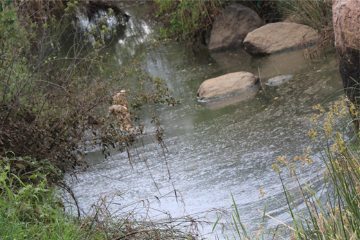
During the field survey, researchers observed aquatic life in some sections of SRC. This resource has the potential to improve the SRC through recreational fishing, contributing to the nutritional requirement of communities if properly managed. Plate 1 shows a section of Segoditshane River with water and vegetation.
 The shallow river channel contains small streams of water flowing between exposed sandy areas. Clusters of tall grass and vegetation grow along the channel and on the banks. The terrain appears uneven with patches of wet and dry surfaces. The water is spread in narrow paths across the sand.
Some Flora found within Segoditshane River
Source: Research findings
The shallow river channel contains small streams of water flowing between exposed sandy areas. Clusters of tall grass and vegetation grow along the channel and on the banks. The terrain appears uneven with patches of wet and dry surfaces. The water is spread in narrow paths across the sand.Some Flora found within Segoditshane River
Source: Research findings
Pollution, safety and environmental concerns.
Observation and interviews revealed alarming conditions, such as the drying up of significant sections of the river due to evaporation and excessive water usage for personal activities such as gardening and illegal car washing activities. This resource can be optimally captured and utilised for the benefit of the urban communities. The results from an experiment which was carried out by the University of Botswana Chemistry Department on a water sample taken from the Segoditshane River classified the river’s water quality as class C (Johansson, 2015). Such a class is acceptable to a limited variety of fish species and irrigation activities but does not support recreation activities such as swimming.
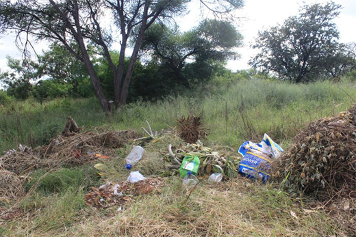
Furthermore, it was observed that water quality in SRC is threatened by pollution and the principal pollutants include overflowing effluent from sewer manholes; disposal of solid waste varying from construction rubble and litter in the form of paper and plastics from packaging materials. This finding illustrates the urgent need for intervention of management strategies to improve river conditions, evident from both public perspectives and expert testimonies. Plate 2 is an image of water pollution along SRC.
Land is another resource which is of paramount importance found within the SRC. The total open space between the identified communities is 25 hectares. Because the SRC was a “no go area” for any physical developments, (Department of Town and Country Planning and Gaborone City Council Physical Planning Office, 2022), this resulted in the neglect and misuse of land as it is being used for illegal dumping of wastes including human littering. Such abuses result in land pollution and subsequent water pollution as the waste is washed into the river course.
From field surveys carried in the study area, it emerged that safety and security concerns were a top complaint from the adjacent communities. The SRC is being used as a hiding place by criminals who are attacking people, regardless of the time of the day. During the data collection exercise, the researchers came across a victim of crime in the study who narrated that:
I was attacked day light as I was coming from Maruapula going to Ginger. As result I lost my cell phone and handbag with cash and some personal documents in it.
The study further established that residents living adjacent experienced increased burglaries and related crimes during the night because of the bush along the SRC. Furthermore, residents expressed their fear of snake bites especially to children who plays or pass through the bush to and from Notwane Primary School. The study further revealed that the river has no flood control measures and the terrain is relatively flat thus making the area vulnerable to flood risks and children risk being washed away in the rain season. From the interviews conducted, it was found that more than 80% of the SRC is misused because of lack of stewardship and lack of sense of place by the communities. This is evidenced by illegal river sand poaching as no one is accountable for the activities taking place within the river.
Air and land pollution is another worrisome misuse surrounding Segoditshane river. Air pollution is mainly due to sewage effluent from illegal sewer disposal from some illegal sewerage collection companies and land pollution is mainly caused by illegal solid waste dumping by some residents (see Plate 3). Observations during field surveys indicated that residents use part of the SRC land as football pitches, and this further pollutes the area as there are no ablution facilities which can be used during the soccer games.
The foregoing discussion shows how qualitative insights from key informants and quantitative survey data can integrate to paint a comprehensive picture of the community’s needs. The lack of safety and environmental degradation underscores the urgent need for designated recreational spaces and community drives management strategies to enhance the socio-economic conditions of residents surrounding the Segoditshane River.
Opportunities for community-based natural resource management–community-based facilities management along segoditshane river.
Most female respondents indicated that they were interested on land uses which are beneficial to the well-being of the livelihoods of their households and families. These respondents suggested that land should be allocated for urban agricultural activities to promote production of fresh produce, thus complementing towards meeting household food requirements. On the other hand, such a use promotes income generating ventures for the unemployed youths and women. Out of the study sample of 29 respondents, 15 suggested that a recreational park would be beneficial as it would draw people closer to the river to accrue benefits associated with rivers as a natural feature and enable them to manage the area around. A soccer coach of one of the social soccer teams highlighted that sports have varied social, health and economic benefits especially to the youth of the communities who are always “roaming around the streets”, without anything to do. Parent respondents proposed that a properly designed recreational park with requisite park furniture such as sitting places and children playing centres should be established in the SRC.
Respondents further indicated that they preferred the setting up of an event hosting centre for the benefit of communities around City of Gaborone. This would host a variety of activities including weddings, religious gatherings and resident association meetings. The study further established that the most desired land use needed was recreation so that people will interact with the river and obtain benefits associated with riverfronts. Civic and community needs were second in the order of preference needs of the communities, followed by commercial land uses to boost economic developments of the river.
Discussion
Current functional state of the Segoditshane River Corridor
The SRC currently functions as an underutilised and neglected urban green facility. Observations revealed unmanaged vegetation, illegal dumping of solid waste and sections of degraded water quality (Class C), limiting its suitability for recreation, agriculture or other community uses (Johansson, 2015; Hansen et al., 2019). Community surveys confirmed these environmental concerns, with residents highlighting safety risks, pollution and underutilisation of natural assets. Key informants from the DWSP, DEA and DTR reported the absence of structured management plans and weak coordination across departments, noting that municipal directives fail to translate into actionable river management strategies (Gaborone City Council, 1996; Stephenson, 2010). These findings align with literature demonstrating that urban green infrastructure frequently suffers from management vacuums, resulting in spaces that are ecologically compromised and socially underperforming (Colding, Gren, and Barthel, 2020; Okolo, 2021; Korkou et al., 2023).
Social dynamics also influence the corridor’s functional state. Survey data indicated that youths were the primary users of the space, often for informal recreation or domestic activities. Observations revealed informal soccer fields and pedestrian use, while survey responses emphasised concerns about safety, including crime and flood risks. These combined insights show that the SRC possesses substantial ecological and social potential, but its functionality is hindered by governance gaps, environmental neglect and the lack of community engagement.
Key success factors for a community-based natural resource management
The study identified several success factors that could support a CBNRM-based approach to managing the SRC. Firstly, inclusive community participation is critical. Survey responses highlighted women’s interest in urban agriculture to support household food security and youths’ demand for recreational facilities. Observations confirmed active but unstructured use of the corridor by these groups. Literature on CBNRM emphasises that local ownership, social capital and inclusive representation are essential for sustainable resource stewardship (Measham and Lumbasi, 2013; Jones and Murphree, 2013; Kumar, 2005).
Secondly, institutional support and coordination emerged as a key factor. Key informants noted fragmented responsibilities and minimal collaboration among government departments, which undermines effective management. Addressing these gaps through inter-agency coordination, clear role delineation and participatory decision-making aligns with CBNRM principles and UFM literature, which stress that stewardship is most effective when formal institutions support, rather than replace, local management efforts (Fabricius and Collins, 2007; Lindkvist et al., 2021).
Thirdly, access to ecological and social resources enables stewardship. Observations identified flora, fisheries and open spaces that could support multifunctional use, while survey participants expressed preferences for parks, event centres and pedestrian trails. Integrating these resources into participatory planning creates opportunities for economic, recreational and social benefits, consistent with urban green infrastructure theory emphasising multifunctionality and social utility (Kim and Song, 2019; Wang et al., 2021).
The proposed community-based natural resource management-community-based facilities management hybrid framework.
In view of the forgoing discussion, the researchers are proposing a CBNRM-CBFM hybrid framework in line with Measham and Lumbasi (2013), Jones and Murphree (2013) and Kumar (2005). Figure 3 illustrates our proposed CBNRM-CBFM hybrid framework for urban river stewardship.
 The conceptual diagram presents integrated urban river stewardship at the centre, illustrated with a river, people, and urban surroundings. On the left, C B N R M community based natural resource management includes community engagement, biodiversity and habitat restoration, and sustainable land use. On the right, C B F M community-based floodplain management includes flood risk reduction, infrastructure maintenance, and disaster preparedness. Arrows connect both sides to the central concept. At the bottom, three linked circles represent ecological health, flood resilience, and social well-being. A lower bar lists participatory governance, capacity building and training, monitoring and evaluation, and resource mobilisation.
The proposed CBNRM-CBFM hybrid Framework for urban river stewardship
Source: Designed by authors
The conceptual diagram presents integrated urban river stewardship at the centre, illustrated with a river, people, and urban surroundings. On the left, C B N R M community based natural resource management includes community engagement, biodiversity and habitat restoration, and sustainable land use. On the right, C B F M community-based floodplain management includes flood risk reduction, infrastructure maintenance, and disaster preparedness. Arrows connect both sides to the central concept. At the bottom, three linked circles represent ecological health, flood resilience, and social well-being. A lower bar lists participatory governance, capacity building and training, monitoring and evaluation, and resource mobilisation.The proposed CBNRM-CBFM hybrid Framework for urban river stewardship
Source: Designed by authors
The CBNRM-CBFM hybrid framework conceptualises urban river corridors as multifunctional community facilities whose sustainability depends on integrating community-based natural resource governance with community-based facilities management. At the centre of the framework is Integrated Urban River Stewardship, which emphasises the simultaneous pursuit of ecological integrity, functional performance and social value.
The CBNRM component highlights community engagement, biodiversity and habitat restoration and sustainable land use, recognising the river corridor as a living ecological system that requires local custodianship. In parallel, the CBFM component reframes the corridor as an operational urban facility that requires systematic maintenance, flood risk reduction and disaster preparedness through community-led management structures supported by public institutions.
The convergence of these two approaches produces three interlinked outcomes: ecological health, flood resilience and social well-being. These outcomes reflect the study’s findings that degraded environmental conditions, safety concerns and underutilisation of the corridor are interconnected challenges that must be addressed through integrated stewardship rather than isolated interventions.
The base of the framework identifies enabling mechanisms (participatory governance, capacity building, monitoring and evaluation and resource mobilisation) that operationalise hybrid stewardship in practice. Collectively, the framework illustrates how combining CBNRM and CBFM provides a practical pathway for transforming neglected urban river corridors into high-utility, community-managed green infrastructure that delivers environmental, functional and socio-economic benefits.
Strategies to enhance the community-based natural resource management-community-based facilities management framework.
Findings suggest practical strategies for operationalising CBNRM in the SRC. Community-driven recreational facilities (soccer pitches, playgrounds and pedestrian paths) could reduce crime and encourage consistent use of the corridor, while urban agriculture plots could support women’s livelihoods and household food security. Event hosting centres provide opportunities for community engagement and revenue generation. Observations and survey data suggest that these strategies are viable because they align with both existing ecological assets and resident needs.
In addition, formalised governance structures are essential. Key informants emphasised the importance of municipal oversight, resources for maintenance and coordinated enforcement to prevent misuse, such as illegal dumping and water extraction. When combined with community participation, such structures can foster co-responsibility, increasing the likelihood that the SRC is maintained sustainably. This strategy resonates well with CBNRM and UFM literature, which underscores that local stewardship succeeds when community initiative is supported by institutional frameworks (Measham and Lumbasi, 2013; Lindkvist et al., 2021; Colding, Gren, and Barthel, 2020).
Finally, multifunctional design interventions can enhance both ecological and social outcomes. Vegetation management, fisheries preservation and structured open spaces allow the corridor to provide ecosystem services (storm-water regulation, micro-climate mitigation) while supporting recreation, income generation and social cohesion. Survey responses suggest that residents value such multifunctional approaches, demonstrating that stewardship can simultaneously improve environmental quality, community well-being and economic opportunity. Figure 4 shows a proposed land use strategy, which was developed by the researchers that can be used to enhance a coordinated CBNRM and CBFM approach to the neglected green facility within the study area.
Participants were dominated by youths and female respondents who were at home during the weekdays. This is an indicator that female and youths in the study area are unemployed. Female respondents are left at home as their male counterparts go to work. Hence these findings are an informer to the best management that will meet the social and economic needs of youths and women. For instance, women respondents could be allocated urban agriculture plots where they can practice market gardening, producing fresh vegetables for income generating purposes and simultaneously meeting their household food needs. The research findings on the existence of fisheries are a potential promoter to recreational fishing which can be tailor-made by the Gaborone City Council to contribute to revenue generation while partly contributing to the nutritional requirements of the community. In this regard, income generating activities buttress the livelihood strategies of locals in the communities hence curtail the undesired effects of unemployment. Furthermore, the incidence of income generating activities due to urban design of the SRC is a potential driver of community self-sufficiency because part of the income generated can be subscribed into the community managed fund to support the maintenance of the corridor.
In addition to that, youths can benefit from the management of recreational park with a variety of sporting arena including basketball pitch, netball court, tennis courts, football pitch and athletic fields. The management of such environs are a potential to the inclusion of the marginalised into mainstream socio-economic life of the City of Gaborone. The existence of vegetation inspires the introduction of new recreation activities such as photography, creation of pedestrian trails and recreational parks, to break the monotony of hardscapes found in the city. Photography is a potential income generating activity to youths. Pedestrian walkways and footpaths mingled with vegetation in front of water in the river course in a recreation park offer refreshing environment to park patrons as they walk and view the beautiful scenery. Additional park-furniture such as sitting places and barbeque areas can provided to cater for the park patrons. Figure 4 is a design proposal for the SRC land use strategy.
 The land use plan map presents a project area divided into labelled portions A, B, C, D, E, F, and G with area values such as portion A 2.01 hectares, portion B 2.8 hectares, portion C 3.92 hectares, portion D 0.5 hectares, portion E 1.3 hectares, portion F 0.6 hectares, and portion G 1.3 hectares. Existing residential areas are arranged in blocks along a network of roads. Proposed 15 metre roads run horizontally and vertically across the site. A river corridor passes through the centre with a buffer zone. The boundary of the project is marked, and surrounding roads include Segoditshane Way and Metsemasewa Road. A legend identifies land uses, roads, river, buffer zone, proposed footpath, and project boundary.
Proposed land use strategy
Source: Designed by authors
The land use plan map presents a project area divided into labelled portions A, B, C, D, E, F, and G with area values such as portion A 2.01 hectares, portion B 2.8 hectares, portion C 3.92 hectares, portion D 0.5 hectares, portion E 1.3 hectares, portion F 0.6 hectares, and portion G 1.3 hectares. Existing residential areas are arranged in blocks along a network of roads. Proposed 15 metre roads run horizontally and vertically across the site. A river corridor passes through the centre with a buffer zone. The boundary of the project is marked, and surrounding roads include Segoditshane Way and Metsemasewa Road. A legend identifies land uses, roads, river, buffer zone, proposed footpath, and project boundary.Proposed land use strategy
Source: Designed by authors
A proposal is thus made to open refresher food market for people while offering job opportunities to locals.
On the other hand, the proposed event hosting centre is a potential driver of environmental care because the centre is a potential crowd puller hence the call for careful management. For instance, the centre might be provided with a safe parking zone for patrons that use vehicles, litter bins for solid wastes from food packaging and ablution facilities. It is thus an important aspect in the regeneration of the SRC because once well managed and patronised, the place becomes safe and secure. Such an intervention contributes towards crime intervention through environmental design. Once more, the design and implementation of SRC is a potential source of employment to the youth and unemployed members of the community. Community involvement in the management of the river is thus a potential booster to the vitality of the community through employing security guards, landscape architects, ushers and managers to keep the places clean, safe and secure. Successful utilisation of the SRC through CBFM and engagement gives the sense of responsibility to locals on the Green Infrastructure because of the benefits and guards against misuse such as unwarranted refuse disposal and unregulated extraction of water from the river.
Implications for the study.
This study provides valuable insights into how urban natural assets, such as the SRC, can be managed through a community-based stewardship model informed by CBNRM and CBFM principles. From a research perspective, the study contributes to the evolving understanding of CBNRM in urban contexts. While historically applied in rural conservation, the findings demonstrate that CBNRM principles can guide the governance of urban green infrastructure and multifunctional facilities. These insights expand the conceptual scope of CBNRM and suggest that future studies could explore comparative applications across diverse urban environments in the Global South, examining variations in community engagement, institutional support and multifunctional outcomes.
In terms of practice, the study highlights strategies for operationalising community-led stewardship. By incorporating resident preferences, demographic realities and existing ecological assets, urban planners and municipal authorities can design interventions that simultaneously enhance recreation, livelihoods and environmental quality. Examples include urban agriculture plots for women, recreational facilities for youth, pedestrian trails and event hosting centres. These interventions can create local employment opportunities, strengthen social cohesion, improve the maintenance and security of public open spaces. The study underscores that CBNRM-informed management is not only socially inclusive but also economically and environmentally sustainable, offering a practical framework for municipalities facing resource constraints.
From a policy perspective, the research underscores the importance of bridging institutional mandates with community engagement. Findings show that fragmented governance structures and minimal inter-agency coordination limit the effectiveness of urban natural resource management. Policymakers could adopt CBNRM-inspired frameworks to formalise community participation, enhance accountability and integrate multifunctional green infrastructure into urban development strategies. Such policy interventions could improve the allocation of municipal resources, reduce environmental neglect, and foster a sense of ownership among residents, aligning with sustainable urban development goals.
Finally, the study has societal implications. By actively involving residents in the stewardship of urban natural facilities, the research promotes environmental awareness, public safety and quality of life. Multifunctional interventions (such as parks, pedestrian trails and urban agriculture) can provide both direct benefits (recreation, food security, income) and indirect benefits (crime reduction, enhanced social capital). Through participatory engagement, communities gain the skills, responsibility and motivation to sustain these assets, creating resilient and self-reliant urban neighbourhoods.
Conclusion
This study examined the SRC in Gaborone, Botswana, to assess its current functional state, identify factors that support community-led management and explore strategies for enhancing urban stewardship. The findings indicate that the SRC is currently underutilised and faces environmental degradation, safety concerns and fragmented governance. Local communities, particularly youths and women, are both directly affected by these challenges and positioned to play a pivotal role in the corridor’s management.
Key success factors for promoting a community-based facilities management approach include inclusive participation, local ownership and coordinated institutional support: core principles of CBNRM and CBFM. The study highlights that integrating community preferences with municipal planning can enable multifunctional interventions such as recreational parks, urban agriculture, pedestrian trails and event spaces. These interventions have the potential to enhance social cohesion, create livelihood opportunities, improve environmental conditions and increase the corridor’s recreational and functional value.
Overall, the research demonstrates that urban CBNRM provides a useful and informative framework for transforming neglected natural assets into high-utility urban facilities. By emphasising community engagement, governance alignment and socio-ecological integration, this approach can guide municipal planning, support sustainable urban development and contribute to improved quality of life for residents. The study underscores the importance of adopting participatory and context-sensitive strategies to manage urban green infrastructure effectively in rapidly growing cities.
Limitations of the study
This study is based on a single qualitative case study of the SRC, which enables in-depth contextual analysis but limits the generalisability of findings beyond similar urban contexts. The community sample was relatively small (29 respondents) and selected through convenience sampling, which may not fully represent the diversity of perspectives across Gaborone. Data were collected at one point in time and therefore do not capture seasonal or longitudinal changes in river conditions, land use practices or community engagement. In addition, much of the evidence is derived from self-reported perceptions and researcher observations, which may be subject to response and interpretation bias despite triangulation. Finally, the proposed stewardship and land-use strategies were not empirically tested.
Directions for future research
Future studies could use longitudinal research designs to examine how community-based stewardship initiatives evolve over time and how sustained participation influences environmental quality, safety and facility performance. Comparative studies across multiple urban river corridors within Botswana and other cities in the Global South would strengthen understanding of how contextual factors shape the applicability of CBNRM-informed urban stewardship models.
Further research could also adopt mixed-methods or quantitative approaches to measure the social, environmental and economic outcomes of community-managed green infrastructure, including impacts on livelihoods, crime reduction, public health and ecosystem services. In addition, pilot implementation and evaluation of the proposed CBNRM-CBFM framework would provide empirical evidence on its operational feasibility, governance requirements and financial sustainability.
