

– The purpose of this paper is to analyze the effects on urban flood from rapidly growing land and housing development projects in flood zones and water bodies in and around Dhaka. The paper further extends the analysis to generate an insight into Dhaka’s urban flood due to possible climate change effects on top of land and housing development projects effects.
– A mixed method was applied for this research comprising qualitative techniques for analyzing the date gathered from reviewing the policies including the Dhaka Metropolitan Development Plan reports, interviews, discussions and maps, whereas quantitative analysis was used to interpret the data gathered from the global positioning system (GPS) survey and questionnaire survey among the resident of the selected housing projects.
– Findings show that a large number of the projects have encroached flood-flow zones and ditches and drainage channels through massive land filling, which resulted in quick changes of land use with wide range of impacts on environment and habitat quality. This study highlighted that the potential climate change impact involves increasing rainfall and subsequent increase flooding. Besides, vast area will be submerged under water and increased warming in the city from high speed built-up area by unauthorized land development.
– The results of the research can be taken into consideration when making political decisions concerning adaptation to climate change.
1. Introduction
Many cities in the developing world have grown at thunderous rates in the past few decades. Without considering laws and regulations, settlements have proliferated wherever a small space is found available, even in disaster-prone hillsides, floodplains or along water bodies. Ad hoc or absent city planning across a patchwork of disconnected city and state offices has left residents at risk on a number of fronts. In South Asia, however, urban communities are most vulnerable in the approaching monsoon months – from June to September – when the potential increases for hazardous and devastating flooding. On top of it, past few decades, climate change has become a major development challenge as it is exerting awesome pressure on social, economic and environmental sustainability, as the world is experiencing rapid social and environmental changes. Increase of population and its needs are the major contributory factors behind these changes. The world’s urban population experienced a 15-fold increase from 200 million in 1900 to about 2.9 billion in 2000, and is estimated to increase to about 5 billion by 2030 (United Nations, 2002). As global population increases rapidly, pressure exerts on the land resulting flimsy cohesion among environmental variables (Green et al., 1994).
Intense human activities on the environment mainly over-exploitation of resources and uncontrolled land development that includes construction of buildings and infrastructures without considering the consequences had increased the impacts of natural disasters in terms of loss of human lives and damage to properties in the past few decades. Human-induced changes in land cover, for instance, influence the global carbon cycle and contribute to the increase in atmospheric CO2 (Alves and Skole, 1996 cited in Alves et al., 1996), which will result an increase in global temperature. The rate of warming averaged over the past 50 years is nearly twice the rate for the past 100 years. This global warming pattern with its pace carries serious environmental and social consequences especially to the coastal and lowland countries, and Bangladesh is likely to be one of the most vulnerable countries in the world in this aspect (Ali, 1999), although Bangladesh emits < 0.1 per cent of global greenhouse gases (compared to 24 per cent for the USA) (Huq, 2001). Possible threats for Bangladesh include sea-level rise, droughts, floods, cyclones, along with different extreme weather events due to the climate change phenomenon (Huq, 2001). Number of research studies (Douglas et al., 2008, Campbell-Lendrum and Corvala′n, 2007, Huq et al., 2007) have explicitly mentioned the threat and vulnerability of the cities and the poor inhabitants to climate change-induced risks and disasters especially the urban flood.
The United Nations Intergovernmental Panel on Climate Change (IPCC) has predicted that impoverished Bangladesh, criss-crossed by a network of > 200 rivers, will lose 17 per cent of its land by 2050 because of rising sea levels due to global warming and Director of the US-based NASA Goddard Institute for Space Studies, James Hansen, paints an even grimmer picture, predicting the entire country could be under water by the end of the century (WWW, 2008). The past 100 years (1906-2005), Earth’s average surface temperature has already risen by around 0.74°C, with the greater warming over land regions than over the oceans. Global surface temperature will increase by at least 2.0°C by the next century (IPCC, 1996a). This pace of global warming has serious impacts on developing country megacity like Dhaka, Bangladesh.
Bangladesh is globally considered as one of the most vulnerable countries to natural disaster. An overwhelming majority, 82.8 per cent of its 150 million people, live in income averaging < 2 dollars a day (UNDP, 2006). Rapid urbanization in Dhaka led to deterioration of city’s environment, particularly mounting flood risk potential (Dewan and Yamaguchi, 2007), severe environmental problems and spectacular growth of informal settlements (CUS et al., 2006; Islam, 1996), which would bring negative impact to the local climate of the city through the unplanned encroachment of the green belt at the fringe areas. Hence, Dhaka, the capital of Bangladesh, will be one of the major victims of regional climate change problem, and climate change will lead to flood vulnerability.
Dhaka, the capital of a small and poor but highly populated developing country Bangladesh, is now one of the ten mega-cities in the world. Dhaka is growing at a very fast rate, > 4 per cent annually, the population of Dhaka urban area is 13.4 million (UN-HABITAT, 2008) and predicted to increase to about 22 million by 2025. Dhaka is also to be the fourth mega-city by 2025. This huge population demands a tremendous amount of housing in and around the city. However, Dhaka city is located geomorphologically at the down stream of the Ganga–Brahmaputra river basin (Ahmed, 1993; cited in Roy and Islam, 2007), and surrounded by eight rivers, namely, the Buriganga, Shitalakhaya, Dhaleswari, Meghna, Turag, Tongi Bangshi and Balu. Two-thirds of Dhaka’s land falls into the flood-flow zone, and traditionally this land keeps Dhaka city free from flooding during flooding season. These flood-flow zone lands are mostly low-lying area and interconnected by drainage channels in Greater Dhaka[1]. Developers have been targeting this lowland for land and housing development projects[2] because of lower land value, but at the same time, pushing the city to potential threat due to climate change effects, such as flooding and warming.
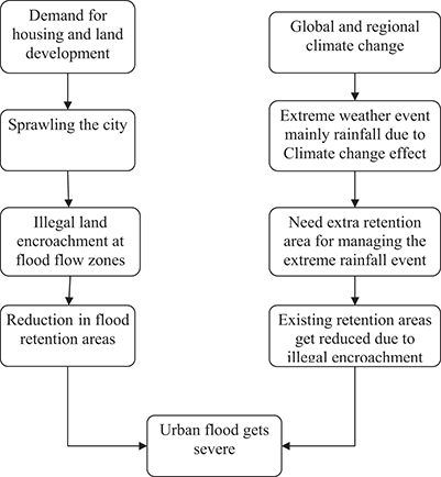
The paper discusses how Dhaka is becoming more susceptible to flood vulnerability by filling up flood-flow zones (FFZ), water bodies like retention ponds, lakes and khals (ephemeral water bodies). The fast-paced housing projects extremely filling the lowlands/wetlands and rapidly expanding the urban built-up area which is resulting increasing heat island. Thus, the city will face climate change effects in future from both recurrent agony from flooding and increasing warming from high-speed high rise urban built in a limited area. The study presents the volume and extent of land filling, its depth of filling by real estate developers and again by individual land plot alleviation by owners to avoid flood risk. In addition, a conceptual framework is formulated to comprehend and realize the scale of effect of those externalities with respect to current climate change phenomenon.
2. Study area
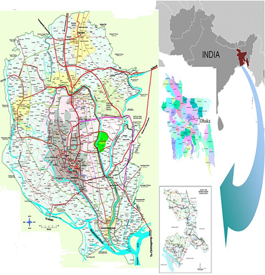
Megacity Dhaka is the primate city of Bangladesh and one of the oldest cities in South Asia and has been consistent over a period of nearly 400 years. The city is located in the central part of the country. It is surrounded by a ring of rivers where it has been enjoying most of the physical, economic and social advantages, and thus, for its steady growth has been receiving primary impulses. Topographically, the land of this region is flat with surface height that ranges from 1 to 14 m, with large part of urban areas located at elevations ranging from 6 to 8 m (FAP 8A, 1991).
For this study, focus is made on the Dhaka Metropolitan Development Plan (DMDP)/Rajdhani Unnayan Katripakkha (RAJUK)[3] planning area which covers 1,528 km2, of which Dhaka City Corporation (DCC) covers 290 km2, Dhaka Metropolitan Police area (DMA) covers 390 km2 and other five municipalities inside of DMDP area; namely, Narayangonj, Kadam Rasul, Gajipur, Tongi and Savar. Although Dhaka generally means the central city, i.e. the jurisdiction of DCC and some adjoining built-up areas, for this paper, the study area covers the planning area of RAJUK. Figure 1 shows the location of Dhaka with its boundary.
3. Data and methods
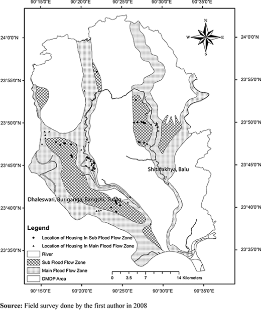
This study was a part of doctoral research by the author, and the article is based on the data and information collected for that research during January to April 2008. A mixed method was applied for this research comprising qualitative techniques for analyzing the date gathered from reviewing the policies including the DMDP reports, interviews, discussions and maps, whereas quantitative analysis was used to interpret the data gathered from the global positioning system (GPS) and questionnaire surveys. The FFZ map was collected from RAJUK to clarify the objective of this study. To conduct the GPS survey, a list of the projects was collected from various sources: namely, RAJUK, Bangladesh Land Developer Association (BLDA) and Real Estate Housing Association of Bangladesh (REHAB, the association of private developers in Bangladesh). After compiling the list, to identify the location and physical condition of projects, a GPS survey was conducted from January to April 2008. A hand-held GPS instrument was used to get the GPS point data for the survey. In addition, on-site field visits were also carefully conducted to physically observe the conditions of the overall housing development projects in the DMDP area. All data, both spatial and non-spatial, collected from different sources were analyzed. The spatial data were analyzed using geographic information system (GIS) tools, and non-spatial data were analyzed using a spreadsheet and SPSS. After collecting the GPS points of the housing projects’ locations in the DMDP area, geo-referencing was carried out to prepare the GIS map and to show the location of housing projects in the FFZ. The prepared map is shown in Figure 3 for the study.
To know the root causes of land and housing development projects’ rapid expansion and associated impacts on human life due to FFZ and water body filling, a field survey was conducted using structured and semi-structured questionnaires with the relevant authorities, experts and among 195 plot buyers from 15 land and housing development projects. To collect the information of the number of plot buyers and the number of affected people, data were collected from RAJUK for public sector and from REHAB and BLDA for private sector housing projects.
As of 2008, 18 approved housing projects developed by the public sector and 33 approved projects developed by the private sector had been completed, of which 15 housing projects were selected for the survey, corresponding to 29.41 per cent of the total projects. A reconnaissance survey was also conducted to physically observe the condition of the housing projects in the DMDP area. Thus, 4 public and 11 privately developed projects were selected for the study based on the reconnaissance survey, considering their similarities in terms of characteristics. Based on the primary data from the reconnaissance survey, similar plot size (0.02-0.03 ha) was considered for the project area from each sector. The features of these projects include:
locations that were mostly 15-40 km away from city center;
similar physical and environmental infrastructures;
similar socio-economic conditions of the inhabitants; and
project starting date from 1983-1990.
Both categories of housing projects were approved by the RAJUK and were located within the RAJUK Planning area of 1,528 km2.
The respondents for this research were selected randomly. A questionnaire survey was conducted among the residents who had been living in the project areas for a long time as well as the owners of the plots. About 30 per cent of households in both categories of project appeared to be relatively long-term residents (> 10 years). The questionnaires were designed in such a way that they would track the causes and problem of increasing flooding, flood damage and factors behind the decreases in flood zones and filling of retention ponds in Greater Dhaka. Afterwards, a semi-quantitative analysis is presented on flood due to runoff water. The framework of the study is presented in Figure 2.
4. Results
4.1 Growth trend of Dhaka city restricted area filling
Since independence in 1971, Dhaka has been witnessing rapid land use change due to:
increasing economic activities;
increasing population due to both natural growth rate and migration; and
due to becoming the center of educational, health and administrative activities.
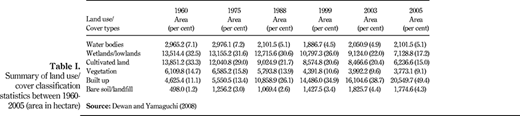
Therefore, rapid land conversion is inevitable for expanding built-up areas. In this regard, Dewan and Yamaguchi (2008) have showed (Table I) the rapid land use change and massive natural resources loss due to urban built-up proliferation in the Dhaka Metropolitan area during 1960-2005.
Dewan and Yamaguchi showed that between 1960 and 2005, agricultural land decreased by 7,614 ha, vegetation decreased by 2,336 ha, wetland/lowland decreased by 6,385 ha and water bodies decreased by 864 ha, and filling up of wetlands obstructs recharging of groundwater. In this period, reduction of wetlands and water bodies made urban fringe more vulnerable to flooding and increased by 15924.3 ha of built-up area resulted a heat island because of enormous building construction, massive car use, emissions, increase use of air conditioning, etc.
4.2 Filling up of FFZ
Dhaka is surrounded by ring of rivers. Most of the areas are low lying and are presently inundated annually during the monsoon months as the water level in the rivers around Dhaka rises. Generally lowlands/wetlands of surrounding rivers store up storm and flood water. Therefore, to protect Dhaka from flooding, DMDP based on the river flow formulated flood-flow zone policy and demarcated the FFZ into two categories;
Dhaleswari, Buriganga, Bangshi, Turag river main flood-flow zone (MFFZ) and sub flood-flow zone (SFFZ).
Sitalakhaya, Balu river MFFZ and SEEZ .
According to the policy any kind of development is strictly prohibited in the DMDP flood zones to avoid future flood vulnerability (DMDP, 1995-2015). As per existing regulation, development permission from RAJUK is mandatory before developing any land as per the Private Housing Land Development Rules, 2004. However, the weak institutional structure and the lack of political unwillingness of RAJUK to implement the provisions of the act (regulated filling and protection of low-lying areas etc) have resulted in unplanned land filling in these fringe areas by unauthorized land and housing projects development (Mullick and Alam, 2009; Alam and Ahmad, 2011).
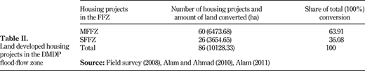
Field data show that most of the housing projects have developed within DMDP-stated restricted areas, completely violating the existing guidelines. According to GPS survey, among 181 housing projects developing in the DMDP area of Greater Dhaka, a large number of housing projects have encroached both flood zones and water bodies. The prepared map from GPS survey is shown in Figure 3 indicated that there are a number of projects located in the FFZ. Total 60 housing projects have developed deviating the MFZZ policy covering an area of about 6,473.68 ha of land. (Table II, Figure 3). Besides, about 26 housing projects developed contravening the DMDP stated SFFZ occupying an area of 3654.66 ha of land in DMDP area.
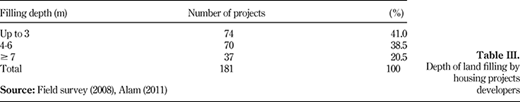
The normal flood-free level of Dhaka is 6 m. The general contour height of the area is 1.5-5 m, whereas the elevation at the central city is the 7-8 m. Thus, to lessen the flood vulnerability earth filling up to 3-5 m is a very popular means for developer and individual. It is estimated from the reconnaissance survey that around 300 housing projects are being developed in the RAJUK area. The survey findings showed the astounding findings where about 41 per cent of the housing projects have filled up to 3 m, whereas 20.5 per cent of the projects have filled even > 7 m of land filling to increase the projects' height and make it free from flood (Table III). This is markedly diminishing the lowland’s flood and storm water storage capacity.
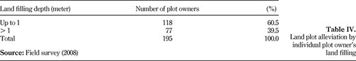
In addition, this research revealed from the questionnaire survey that individual plot owners of these projects also elevated their plots' height through infilling to avoid flood. A survey conducted among 195 plot buyers showed that 60.5 per cent of plot owners increased their plot height by up to 1 m after buying from developers, while 39.5 per cent increased by > 1 m (Table IV). These 195 respondents are living in 15 projects within the area of 390 km2 of DMA, where plot alleviations required minimum height. Certainly beyond 390 km2 and within 1,528 km2 DMDP area will require more individual plot alleviations, as these are mostly low-lying areas. Twofold land filling by developer and individual plot owners are cumulatively reducing the water storage capacity and increasing perennial water logging in the built-up area. Thus, the city is gradually becoming a potential threat to the everlasting climate change because of increasing rain and heat due to climatic effect.
4.3 Filling up of water bodies
The highland areas within the city have already been developed. Population pressures and requirement for more urban land for housing within the city boundaries have resulted in encroachment by the real estate developers of the water bodies like ditches, drainage channels, canals and wetlands/lowlands which acted as flood retention ponds[4]. These facts were highlighted at the stakeholder consultations during field visits where the representatives for civil societies presented the case of encroachments of the Hatirjheel and Begun Bari Khal, two important wetlands in the central and southern parts of the city. These two canals are linked to the Norai Khal which drains water from a large part of the city (Sea and DMDP, 2008). Both these wetlands have already been encroached; approximately 1,200 illegal encroachments have been enumerated by RAJUK in Hatirjheel area. In addition, during the tenure of the 2001-2006, land of this city part was allocated by the then government to Hotel Hilton International, Federation of Bangladesh Chambers of Commerce and Industry (FBCCI), International Arbitration Centre and a number of compressed natural gas filling stations for setting up offices, etc., even though the Wetland Protection Act 2000 prohibits filling up of lowlands. It has been reported that land was allotted to FBCCI at a nominal price of BDT[5] 100,000 without any public bidding, even though it is mandatory as per the procedures of the Government of Bangladesh. Implementation of these projects would result in greater inundation of the city’s central areas.
Overall, the retention ponds of Dhaka are supposed to have 260 km drainage system; presently it has only 160 km (The Daily Prothom Alo, 2008). Besides, around Dhaka, there were 250 canals and lakes. These open canals, lakes were well interconnected with surrounding rivers and wetlands. During urban developments, small channels are often considered as being insignificant and are destroyed, but in reality, they play a key role in easing flood peaks. These are the water passing channels through the city into the main rivers, wetland and low-lying areas. Beginning from 1990s, these low-lying areas or wetlands, lakes, khals and drainage channels are the main target of real estate land developers. In 2005, Dhaka Water and Sewerage Authority identified 45 khals (The Daily Prothom Alo, 2008), of which 35 khals at present show no sign to recover (The Daily Sangram, 2008). Previously, width of these khals was 150 ft; continuous encroachment by different quarters of people and developers has narrowed them down to 15-10 ft. As a result, even with 10 mm rain, Dhaka city faces sever water logging and drainage congestion and consequently flood in the urban Dhaka indicating future flood vulnerability to climate change effects. At present, public developers like RAJUK and National Housing Authority (NHA) are also filing up the existing retention ponds of the main city violating DMDP law. This study revealed that:
RAJUK under Uttara Modet Town 3rd Phase has developed 150 plots by filling up 100 meters wide Uttara lake and has developed more 400 plots at Gulshan-Banani-Baridhara Project filling up Gulshan-Banani lake and the project also narrowed down the lake from 500 to 80 feet. On the other hand NHA has constructed 3,300 apartment at Banani-Mohakhali in the city by filling up of 43 acres of lake (Field visit, 2008; The Daily Sangbad, 2009; Alam, 2011).
These encroachments also have broken the interconnectivity of the lakes and canals to the surrounding rivers resulting in recurrent water logging and flooding problem during monsoon. During our discussion, experts also feared that floods of magnitudes experienced in 1988, 1998 and 2004 may occur more frequently in future due to the climate change effects.
4.4 Impacts of filling up of FFZ and water bodies
As spatial expansion of Dhaka is highly constrained by the physical factors of eight rings of rivers, so most of these developments have been resulted in the loss of natural resources in a very limited area. These will, on one hand, cause incessant flooding because of water body filling up and increased urban built-up on small area, on the other hand, it will increase city warming from thousands of buildings, emission from traffics and high energy use of the vast 13.4 million population. Therefore, the megacity will face immense climate change-related problems because of unplanned development of its urban area. Researchers studying the impact of climate change on Dhaka predict that the city will be affected in two major ways:
flooding and drainage congestion; and
heat stress (UN-HABITAT, 2008).
At present, inhabitants of Greater Dhaka are experiencing two types of flooding in the city:
urban flood, which is classified as the city inundation caused by drainage congestion and water logging; and
river flood, which is classified as the city inundation caused by overbank flow of the rivers in monsoon season.
Findings of the study signify that numbers of housing projects have fallen into DMDP main MFFZ and SFFZ. This deviation poses great threat to the Dhaka City’s sustainability. In such fringe areas, the intrinsic ability of these FFZ to retain or store excess water during periods of high rainfall is getting reduced. As a consequence, the risk of flooding continues to increase due to climate change risk in Dhaka and adjoining low-lying areas which are now being charted for future development.
Studies also demonstrated that the encroachment of floodplains in Dhaka aggravated flood hazard in the city instead of securing people from persistent flooding in the monsoon (Dewan et al., 2004). In contrast, developers as well as the individual household are also largely responsible to develop the fringe zone (Islam, 1996, 2005). Land conversion by individual for speculative purposes has also greatly been influencing the development of suburb and flood-prone areas as observed during field visits (Alam and Ahmad, 2010). Hence, unregulated expansion by real estate housing projects in DMDP area is underway and leading to serious climate change threat.
5. Climate change and its potential impacts on Dhaka
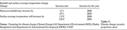
Climate change scenario projections of Bangladesh in Table V shows that rainfall may significantly change over normal (i.e. current variability). Monsoon rainfall may increase by 11 per cent by 2030 and 27 per cent by 2070. Also, the general rise in surface average temperature will increase by 1.3°C by 2030 and 2.6°C by 2070.
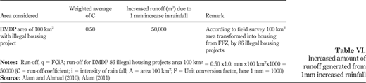
For the Ganges–Brahmaputra–Meghna basin as a whole, the increase in rainfall in the monsoon is predicted to be larger from 4-8 per cent by the 2020s and 9-10 per cent by the 2030s, while winter rainfall is expected to reduce by 4-5 per cent by 2050 (Tanner et al., 2007; CDMP and DOE, 2006). Of the annual precipitation that falls on Bangladesh, > 80 per cent comes during the monsoon period (Smith et al., 1998), and it is the same for Dhaka region as well. Climate Change Cell of GoB also mentioned that the number of rainy days will also be increased by 20 days. Rain flood is already a severe problem for Dhaka city; however, increase in rainfall amount and events due to climate change phenomenon with increasing built-up from rapid urbanization by land housing project development will intensify the problem manyfold. An analysis is presented in Table VI using the rational formula of runoff (q = FCiA) (Pilgrim and Cordery, 1992), with a scenario of only 1 mm increase of rainfall in the monsoon period in existing urban land-use pattern. It gives an extra runoff 50,000 m3 from DMDP area. The study confirm that 100 km2 areas which are found transformed into residential area by 86 unauthorized housing projects would generate additional 50,000 m3 of runoff due to only 1 mm increased rainfall considering surface runoff coefficient as 0.5 (Alam and Ahmad, 2010; Alam, 2011, 2013).
On the other hand, flooding after rains is already a severe problem for Dhaka City because of the massive encroachment of the ditches and drainage channels and filling of lowlands/wetlands by land and housing projects developers. However, the potential increase in rainfall and related events due to climate change with increasing intensity will aggravate the problem manyfold resulting in potential increase of urban floods (Alam and Ahmad, 2010; Alam, 2011).
The IPCC data show that sea level was rising between 1993 and 2003 at a rate of 3.1 mm per year (Alley et al., 2007). Therefore, the combined effects of subsidence and sea-level rise could result in increasing vulnerability to flooding events, serious drainage congestion and sedimentation problems, in addition to coastal erosion and land loss which means that even a slight rise in the sea-level rise is likely to engulf large parts of the city of Dhaka. A combination of such effects will have immense socio-economic impacts in the region. In quantitative terms, for example, a 1m rise could flood almost 30,000 km2 of Bangladesh, affecting > 13 per cent of the population, mostly in the lower deltaic regions of the south (Sea and DMDP, 2008).
About 15,000 Himalayan glaciers for a unique reservoir which supports perennial rivers, such as the Indus, Ganges and Brahmaputra, which, in turn, are the lifeline of millions of people of Bangladesh (IPCC, 2007). Experts believe that the melting of glaciers and snow in the Himalayas, along with increasing rainfall attributable to climate change, will lead to extensive flooding in Bangladesh in more general, especially in cities located near the coast and in the delta region expanding through lowland and FFZ filling, including Dhaka. Dhaka may also experience increased temperature from rising levels of vehicles' exhaust emissions, increased industrial activities and increased use of air conditioning in the rapid growing urban built-up area. Moreover, high urban growth rates and high urban densities have made Dhaka already more susceptible to human-induced environmental disasters. With an urban growth rate of > 4 per cent annually (UN-HABITAT, 2008), Dhaka, which already hosts > 13.4 million people with astounding figure of 2,600 population/mi2, is one of the fastest growing cities in southern Asia and is projected to accommodate > 20 million population by 2025. The sheer number of people living in the city means that the negative consequences of climate change are likely to be felt by a large number of people where large numbers of housing projects (approximately 300) are being developed in the low-lying areas, especially the urban poor, particularly children and women who live in flood-prone and water-logged areas with substandard or non-existence of sewage facilities.
The height of the DMDP area varies between 2 and 6 m above sea level. The area is also known to be undergoing tectonic subsidence at an average rate of 0.62 mm/year, but can reach up to 20 mm/year (Sea and DMDP, 2008), thus effectively lowering the height compared to the sea level. In addition, a large part of the fringe areas of Dhaka comprising about two-thirds of the DMDP area are characterized as FFZ. These areas are extremely prone to flooding and remains under water for most parts of the monsoon season due to overflow of the channels of the rivers Buriganga, Sitalakhya, Balu, etc. These geographical and physical conditions though have also played a negative role in expanding the growth of the city spatially. Rapid filling of these wetlands/lowlands and flood-flow zone land of Dhaka by real estate developers up to 2-3 m in the one hand, on the other hand, real estate developers’ massively encroaching retention ponds like lakes, ditches and interconnected drainage channels of Dhaka. Consequently, the city is becoming significantly more vulnerable to flooding and water logging during the monsoon season.
As a result of climate change effects, Dhaka will get adversely impacted in the following ways:
Increase in flood vulnerability in the surrounding low-lying areas would act as a disincentive for the city to expand spatially and disperse the urbanization process to accommodate the rising urban population thereby coming in the way of expansion of the city which may in turn impede the economic growth linked with the capital city. On the other hand, this will lead to vertical development of the city that will generate heat island by bringing huge vehicles, energy use and industrial activities.
The increase in flooding potential would aggravate flooding problems within the city. It has been established during earlier flood events that the aggravation of flood situation in the city has been as a result of backwater flow from the larger rivers which again could not drain out excess water because of tidal influences and already-filled FFZ land. Usually small change in temperature, rainfall (analysis shown in Table VI) and sea-level rise can lead to severe consequences for a country like Bangladesh already stressed environmentally, socially and economically. Bangladesh experiences more monsoons in dry season. In the case of an increase in any of three main factors, temperature, rainfall and sea-water levels, this problem may get more severe in the fringe area of Dhaka.
The associated problems of climate change leading to loss of land and livelihood for economically disadvantaged people residing in the surrounding regions of Dhaka is expected to result in creation of a large inflow of refugees into Dhaka, which is the only large city in the area that can provide them alternative livelihood opportunities.
6. Conclusion
It is evident from discussion that unauthorized housing projects development to a great extent is responsible for climate change effects in Dhaka. The sheer sufferings of the effects have to be borne by poor people who are living in the low-lying water-logged areas. Rapid housing projects development in FFZ and ditches and drainage channels filling will bring lasting urban climate change, as flooding for Dhaka in one hand and new urban growth and increased densities will bring climate change effect of heat island from increase vehicle emissions, more traffic, rapid increase of energy use and decrease of green belt on the other hand. Furthermore, housing projects development also lead to sprawl. Climate change will affect river discharge as well as river-water level which is extremely important for draining out city storm water. At the monsoon time of the present situation, the water levels of the surrounding rivers of Dhaka city get higher than the inside city terrain water level, and due to climate change this phenomenon will obviously be intensified. In this regard, this study shows that unauthorized land filling will cause severe urban flood and flood damage; hence, potential threat due to climate change on urban flooding has been demonstrated in this study with a simple calculation like the increase in runoff volume due to a mere increase in 1 mm rainfall (Table VI). The paper concludes that a slight increase in rainfall in a given duration, which is occurring or going to happen in near future due to climate change phenomenon will obviously result tremendous amount of runoff, and Dhaka city does not have the capacity to withstand such a volume, which consequently will result in increased urban flooding and flood damage in and around the city.
It is also clear from the discussion that main causal links leading to environmental degradation are institutional failures and lack of enforcement of policies which provide disincentives for environmental conservation. As a result, en masse flood zones filling, ditches and drainage channels encroachments are the main reasons for severe human-induced climate change effects of flood hazards and city warming. But practically it is possible to save Dhaka from this human-made disaster by rescuing and protecting FFZ, retention ponds, wetlands/lowlands, from mighty real estate developers by formulating appropriate policies, rules and regulations and its implementation and monitoring.
Summary of land use/cover classification statistics between 1960-2005 (area in hectare)
Summary of land use/cover classification statistics between 1960-2005 (area in hectare)
References
About the authors
Md Jahangir Alam is a faculty member in the Department of Sociology, University of Dhaka, Bangladesh. He obtained a PhD degree in Regional and Rural Development Planning at the School of Environment, Resources and Development, from Asian Institute of Technology, Bangkok, Thailand. His professional experience involved teaching and research at the Department of Sociology, University of Dhaka, Bangladesh. Before joining University of Dhaka, he was an Assistant Professor at the Department of Sociology, Shahjalal University of Science and Technology, Sylhet, Bangladesh. His research interests include land development and urban environmental management, land and housing projects, problems of urbanization and urban resource management. Md. Jahangir Alam is the corresponding author and can be contacted at: jahangirsociology@gmail.com
Reaz Akter Mullick is a faculty member in the Department of Civil Engineering, Chittagong University of Engineering and Technology, Bangladesh. He obtained a PhD degree in Water Engineering and Management from Asian Institute of Technology, Thailand. His research interests include integrated water resources management, hydrology, water resources economics, environmental flow, modeling of the water resources system and climate change impact on water resources.
The present study was part of doctoral research by the first author conducted at RRDP, AIT, Thailand, with financial support from the University of Dhaka, Bangladesh, and AIT. The authors gratefully acknowledge the financial supports to carry the study.
Notes
Dhaka megacity or DMDP Area/RAJUK planning area of 1,528 km2 is popularly termed as Greater Dhaka (Islam, 2005, p. 10).
Land and housing development projects are land development by public and private sector where the public sector receives land by acquisition while private developers purchase/grab and develop and make such land into subdivisions as plots, and then obtain approval from RAJUK for plot selling. It is expected that planned residential development takes place with adequate social, physical and environmental infrastructures.
RAJUK [Rajdhani Unnayan Katripakkha] the Capital Development Authority which is regional planning organization responsible for planning, development and development control of 1,528 km2 area of Greater Dhaka.
Water retention pond may be interpreted as water reservoirs, lakes, canals, ponds, ditches and drainage channels that are naturally lowlands and store water.
1 US$ = 74 Bangladeshi Taka.
