


– This paper aims to propose a collaborative approach toward an integrated vulnerability assessment to climate change in Germany that attempts to bridge the gap between scientific output and policy demand.
– Conceptually, the approach follows the definition of vulnerability as used by the Intergovernmental Panel on Climate Change, but it has modified this basic concept. It clearly distinguishes between three time slices (presence, near and remote future) not only regarding the change in the climatic conditions but also socio-economic development trends.
– The paper concentrates on the selected methodological framework, the collaborative research design and those preliminary results of the nationwide vulnerability assessment that are transferable to other settings.
– A Vulnerability Network (“Netzwerk Vulnerabilitaet”) emerged from an applied research project commissioned under the Adaptation Action Plan of the German Strategy for Adaptation to Climate Change by the Federal Ministry for the Environment, Nature Conservation, Building and Nuclear Safety and the Federal Environment Agency. The assessment serves as evidence basis for the implementation of the German Adaptation Strategy. Thus, all relevant federal authorities and agencies are represented in the Vulnerability Network.
– The approach is the first really integrative vulnerability assessment for the whole Germany, as it considers not only 16 sectors but also interconnections between these sectors and cumulative effects for three different time slices. Moreover, the normative component of the assessment was clearly separated from the analytic one. The Vulnerability Network as a whole has been responsible for all normative decisions to be taken during the assessment procedure thus ensuring a wide understanding and acceptance of commonly achieved results.
1. Introduction
1.1 Research background and relevance
This paper elaborates on the so-called Vulnerability Network (Netzwerk Vulnerabilität) which emerged from an applied research project commissioned under the Adaptation Action Plan of the German Strategy for Adaptation to Climate Change (APA) by the Federal Ministry for the Environment, Nature Conservation, Building and Nuclear Safety (BMUB) and the Federal Environment Agency (UBA). Subject of the Vulnerability Network is a cross-sectoral analysis of Germany’s vulnerability to climate change. The Network consists of 16 relevant federal authorities, as well as agencies and a scientific consortium (see www.netzwerk-vulnerabilitaet.de for more information).
The German Strategy for Adaptation to Climate Change (DAS) sets the frame for Germany’s national adaptation process. The DAS is designed as a stepwise process. First step was the approval of the National Adaptation Strategy (DAS) by the Federal Cabinet (Bundesregierung, 2008). The second step, the Adaptation Action Plan, was adopted in 2011 (Bundesregierung, 2011). The next step is the formulation of the progress report of the DAS in 2015, which will contain a national vulnerability assessment and a second Adaptation Action Plan. The output of the Vulnerability Network will serve as the official evidence base for the second Adaptation Action Plan and further adaptation actions to be taken by the federal ministries in Germany.
Until now, decisions on adaptation actions in Germany at the federal level are lacking a cross-sectoral vulnerability assessment to climate change as an evidence base. Existing studies focus on single sectors (such as water, health, etc.), but disregard the interconnections between these sectors. However, at the same time, territorial development is generally considered to be very important for dealing with climate change, as it is, for example, regarded to be responsible for and capable of reducing regional vulnerabilities to climate change, as well as developing climate mitigation and adaptation capacities against the impacts of climate change (Stern, 2006; Parry et al., 2007). In the European Union Territorial Agenda, it is stipulated under Priority 5 that:
[…] joint trans-regional and integrated approaches and strategies should be further developed in order to face natural hazards, reduce and mitigate greenhouse gas emissions and adapt to climate change. Further work is required to develop and intensify territorial cohesion policy, particularly with respect to the consequences of territorially differentiated adaptation strategies (BMVBS, 2007, p. 7).
Existing studies lack a fine-grained, Geographical Information System (GIS)-based assessment component that uncovers the regionally diverse patterns of climate change impacts. These spatial patterns need to be identified for territorially differentiated adaptation efforts (Schmidt-Thomé and Greiving, 2013). Finally, existing vulnerability studies conducted by the different Federal States of Germany have applied different methodologies. As a consequence, a comparative nationwide view on given patterns of impact and vulnerability is not possible.
The methodology for such an integrative and, at the same time, spatially explicit assessment needs to be based on a collaborative scientific concept. The gap between scientific output and policy demand has often been described (Weichselgartner and Kasperson, 2009). Experience from past projects has shown that results, achieved in cooperation with the authorities responsible for adaptation, are better understood, better accepted and more likely to be integrated in the further adaptation process than outcomes from work solely carried out by scientists. In addition, consensus building is seen as a methodological concept for tackling uncertainty (IRGC, 2005; Greiving and Fleischhauer, 2012). This approach was chosen to address the science-policy gap (Section 2.1) described above, which had been identified as one of the major shortcomings of previous projects (Schauser et al., 2014). Its aim was to not only inform stakeholders about final results but also obtain their expert input, discuss approaches and intermediary results with them and cooperatively resolve all normative issues, leading to a process of science-stakeholder collaboration within the network (Cohen, 1997; Jones, 2001; de la Vega-Leinert and Schröter, 2008).
Therefore, the Vulnerability Network was designed from the beginning onward as cooperation between a scientific consortium, as part of a research project, and federal authorities from relevant sectors as expert network to work together throughout the whole vulnerability assessment process.
1.2 Objectives
The overall goal of the Vulnerability Network is a comprehensive, nationwide, cross-sectoral and consistent vulnerability assessment to identify hot spots of vulnerability to climate change in Germany. The sectors to be considered – such as water, human health, biodiversity, transport and others – are pre-defined by the DAS. The work of the Vulnerability Network includes:
The establishment of the network and the organization of decision processes within the network.
A semi-quantitative synthesis of existing supra-national, national and regional studies of climate change impacts and vulnerability assessments.
The development of a consistent methodology to produce a comprehensive overview of vulnerability in Germany as the basis for the prioritization of climate threats.
The implementation of the developed methodology in a nationwide, integrative, quantitative and narrative assessment.
The results of the Vulnerability Network will provide the basis of the vulnerability analysis as part of the progress report of the DAS in 2015. Core will be the identification of spatial and thematic hot spots of vulnerability. This paper concentrates on the selected methodological framework, the collaborative research design and those preliminary results of the nationwide vulnerability assessment that are easily transferable to other settings.
1.3 Challenges
The following challenges were encountered during the development of the research approach and were thus subject of discussions during the dialogue process within the Vulnerability Network:
Terms and definitions: Different disciplines, authorities and stakeholder communities usually become used to a certain way of interpreting key terms and definitions. As a result, the same term often has a different meaning in another discipline (need to agree on common terms for the research). These common definitions are explained in Section 3 of this paper.
Scientific frameworks: It became obvious that there was a major division line between experts, who were more acquainted to the disaster-risk reduction and others used to the Intergovernmental Panel on Climate Change (IPCC) vulnerability framework. Thus, there was a need to agree on a common framework for the research. The commonly accepted framework is described in Section 2 of this paper and its necessary modifications resulting from the discussion process in Section 3.
Complexity and range of the subject: The identification of the system’s elements (exposure, sensitivity, impact and adaptive capacity) and the complexity of interrelations often lead to abstract and diffuse discussions. Thus, there was a need to work with visualizations as a basis for discussion. Examples for this visualization are discussed in the following paragraphs.
Sector perspective: Considering the multitude of sectors when designing the main connections between climate change and its impacts, there is a challenge to produce a comprehensive view of the sectors. Experts that represented a specific sector frequently promoted their very detailed views of that sector. Thus, the main challenge was to balance between applicability and detail. Consequently, the network members selected the most relevant impacts in each sector according to the importance of their potential sectoral effects, as well as possible interconnections between different sectors.
Completeness: As there are always different perspectives on the different sectors, the question was whether all relevant aspects were covered from not only the scientific but also from the political perspective. Here, there was a need to receive feedback from public authorities and their superior political entities (ministries) which was a quite time-consuming process.
Acceptance and transparency: As the vulnerability assessment aims at a national and cross-sectorial approach, it was important to achieve a broad acceptance among the involved scientists and experts from the Federal Authorities, including the transparent discussion of the methodological approach, the selection of most important impacts and the selection of related indicators. Thus, intensive discussions were needed to inform and give opportunities to discuss the conceptual approach and interim results. For this purpose, a series of network meetings and experts’ workshops was organized.
2. Conceptual framework
2.1 Collaborative science
When the vulnerability to climate change is at stake, science by nature aims at estimating future impacts with the highest precision possible. As a consequence, a great amount of resources, effort and time is spent on the development of sophisticated methodologies and tools. The application of these tools generate outcomes such as projections of atmospheric processes, regional climate models, the analysis of potential impacts on eco-systems and societies, as well as their potential to withstand such impacts. These results provide a realm of data and information that represent important contributions to the various components of the overall vulnerability such as exposure or sensitivity. However, they are not directly useful in supporting decision-making in practice.
In this paper, the focus is on decision-making in the public rather than the private sector. Within the public sector, the final decision on which strategy to follow or which measure to implement for adapting to climate change is – among others – directly connected to political priorities and available resources. Thus, the work of public decision-makers in town councils or state parliaments and administrations aiming at planning and implementing adaptation strategies and measures implies a selection from and assessment of the scientific output. Often the expectations of decision-makers do not match the results of the scientific process. The scientific estimations of future climate change impacts are connected – especially at the local scale – with deep uncertainty and they are context-specific, whereas the practitioners need evidence and messages that are easy to understand (Walker et al., 2013). Especially, a cross-sectorial decision-making process is a complex procedure that needs tailor-suited tangible and concise results communicated, for example, as the identification of sectorial or spatial vulnerability hot spots or the assessment and analysis of particular adaptation options. The role of science in this context is problematic because science cannot give a proof of vulnerability in view of given uncertainty. Science in this context is inconclusive (van Asselt, 2005). Hereby, justification of actions and consensus about thresholds for acceptable risks and response actions becomes more important (Greiving et al., 2012). Within the collaboration of science and society, trust, transparency, clarity and confidentiality can be seen as key issues (Löfstedt, 2005; IRGC, 2005; Greiving, 2009).
This gap between scientific output and policy demand has often been described (Weichselgartner and Kasperson, 2009). To solve it, the following major challenges need to be addressed:
Reduction of data and information as well as aggregation of intermediate results in a scientific sound and transparent way.
Communication of the complexity of underlying data sets and the uncertainty associated with the applied methodologies and with the results.
Fulfillment of the user requests to provide results from a rather systemic point of view. That is to take into consideration cross-sectorial interlinkages, the multiplicity of threats or adverse impacts as well as inner-systemic feedback loops.
Agreement on the numerous normative decisions that need to be made for the selection of methodologies, the prioritization of threats, potential impacts or sectors, the analyses of intermediate and final results etc. Due to a lack of existing legally based norms and thresholds, justification of actions and consensus about thresholds and priorities can be understood as an appropriate way for dealing with uncertainty.
The difference in future periods of relevance – that is, the usually long-term perspective of climate change science (of ca. 100 years) needs to be brought in line with not only the common time horizon of political decisions but also actions to be taken by spatial planning (about 15 years maximum).
Even though these potentially problematic aspects are not new (Greiving et al., 2012; Greiving and Fleischhauer, 2012; Fleischhauer et al., 2012), most research activities are modest and/or late in communicating with the potential users. To overcome this constraint, the hereby presented Vulnerability Network follows a new concept to merge user needs and scientific approach from the very beginning of the work.
2.2 Understanding vulnerability to climate change
2.2.1 The IPCC vulnerability concept.
Climate change will have widely differing regional manifestations by virtue of climatic variations specific to a region, sensitivities differentiated by region and sector and a differentiated capacity to adapt to climate variations. A solid evidence base is needed to be able to deal with these spatially specific challenges through appropriate political and planning action.
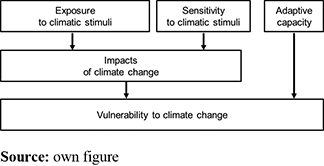
Here, the relevant conceptual framework is the so-called IPCC vulnerability concept (Parry et al., 2007). The key elements of this concept are shown by the following Figure 1. Vulnerability represents the final outcome of an assessment of the exposure to climate change, the sensitivity of the system, subsequent impacts and the capacity of the system to adapt to these impacts.
Chambers (1989, p. 1) separates the concept of vulnerability from the concept of poverty within the context of development research as follows:
Vulnerability […] is not the same as poverty. It means not lack or want, but defencelessness, insecurity, and exposure to risk, shocks and stress […]. Vulnerability here refers to exposure to contingencies and stress, and difficulty in coping with them.
The concept of vulnerability is today no longer restricted in its use to the analysis of the functionality of specific ecosystems and as a parameter in the determination of risks (Birkmann, 2006; Schmidt-Thomé and Greiving, 2008; Greiving et al., 2012), but rather refers to a wide spectrum of social, economic, institutional and ecological hazards, as well as their interactions, and is even used to describe a so-called “generic vulnerability of social groups and societies” (Young, 2010).
There are synergies between adaptation to climate change on the one and disaster risk management on the other hand (Field et al., 2012; Costa and Kropp, 2012), but this paper follows the basic IPCC concept of vulnerability which is widely used to structure (or to develop) adaptation strategies at different spatial scales.
2.2.2 Modification needs.
Whilst the climate change signals expressly refer to future climate changes, the time frame for the other elements is not defined. In studies carried out so far, the current status is generally taken as the benchmark (Adger, 2006; Füssel and Klein 2006; Schmidt-Thomé and Greiving, 2013). This applies particularly to sensitivity, which relates to the status quo of the system and frequently disregards future changes (for example, building of housing estates, demographic change, change in land use) (Black et al., 2008). This has to be regarded critically, as certain vulnerabilities will only emerge through the alteration of sensitivity, e.g. the risk of damage through natural hazards will in the future presumably only rise under the combination of more land in potentially endangered areas being built on and a potential increase in natural hazards brought about by climate change. Accordingly, the time frame for adaptive capacity has not been defined (Costa and Kropp, 2012). The use of the term “capacity” indicates that reference to the period of time when possible future measures might be adopted (Schröter et al., 2005). Thus, adaptation capacity is about what could be done in the future, but viewed from a present-day perspective (the measures that could be adopted in the future, using instruments and procedures available today). Of course, even this must be assumed to change in the future. We may deduce from this that vulnerability cannot be tied to any fixed time frame either.
Basically, in current vulnerability studies, the system, such as it is right now, is pitted against future climate change as if this change was to happen more or less entirely tomorrow (see European Environment Agency, 2012 for an overview). In contrast to this common approach, we prefer to rely as well on projected values for evaluating sensitivity and adaptation capacity as much as possible (Birkmann et al., 2013; van Ruijven et al., 2014). The socio-economic scenarios to be used in this exercise, however, tend to be even more uncertain than the climate projections and, as a consequence, we call our outputs “vulnerability scenarios”. We hope that this approach will, as advancement to a “vulnerability assessment” that is based on current sensitivity and adaptive capacity, fuel the discussion on sector and regional adaptation requirements within government and public authority networks. This approach supports the demands for climate change adaptation as set out recently by Working Group II as contribution to the fifth assessment report of the IPCC (Field et al., 2014; O’Neill et al., 2014).
Climate- and weather-sensitive systems exhibit, as a rule, a long history of adaptation measures for dealing with climate and weather extremes. From technical measures such as dykes for flood control, torrent and avalanche control in the Alps or early warning systems right up to measures such as insurance against damage from hailstones or modern risk communication systems. The degree of already realized adaptation to climate and weather extremes (in contrast to the capacity to adapt in the future) is only faintly mirrored in the vulnerability concept of the IPCC, hidden within the concept of sensitivity (Adger et al., 2005). On the other hand, the potential for applying additional measures definitely belongs to adaptation capacity. Such adaptation measures might be adopted to limit a particular potentially negative effect of a projected impact of climate change. In addition, a sector or society as a whole has to be better prepared for climate change (Schneiderbauer et al., 2011). However, it is still not clear how aspects such as “political will” or “efficiency of adaptation measures”, should be taken into consideration. Schröter et al. (2005) suggested a separation into “awareness”, “ability” and “action” for this, which we have adopted in the network project. Even so, we cannot start from the assumption that all adaptation measures and all elements of adaptation capacity can be assessed quantitatively. Here, we need to draw on expert knowledge which, in the narrative form, will be highly relevant when assessing certain elements of vulnerability.
It is not clear from the IPCC concept whether extreme events feature at all in the vulnerability assessment, and, if they do so, in which particular element of the concept they might play a role. The influence of changes in temperature and precipitation is probably, but with a high degree of uncertainty, linked to such extreme events (Field et al., 2012). Their frequency and magnitude are influenced by weather and thus by climate, as explained by Table 3.1 in Chapter 3 of the SREX Report “Changes in Climate Extremes and their Impacts on the Natural Physical Environment” (Field et al., 2012, p. 119ff.). This report distinguishes between phenomena which are directly and immediately related to atmospheric changes such as storms or El Niño: events (“Phenomena Related to Weather and Climate Extremes”) and extreme events which have a direct effect on the physical environment such as droughts, floods, rising of the sea level or mass movements (“Impacts on Physical Environment”). Consequently, for a study focusing on Germany, some extreme events (i.e. the different types of floods) should be regarded as primary impacts because the extent of the event and its impact is dependent on the sensitivity of the human environmental system and can be alleviated in the future through adaptation measures. The magnitude of a flood event, for example, is, to a large extent, dependent on the impervious surfaces in the catchment area, which can be influenced by planning based decisions like improving the retention capacity. On the contrary, storms and rising sea levels as processes cannot directly be mitigated, but its second-order impacts, because coastal protection can be strengthened and wind resistance of buildings can be increased to withstand higher wind speeds.
3. Methods – proposed vulnerability assessment concept
The Vulnerability Network aims at two major outcomes of different characteristic: the first main objective is the cross-sectorial and Germany-wide assessment of vulnerability to climate change as important input for the further implementation of the adaptation strategy. The second major goal is the generation of a platform for the exchange of information and knowledge about climate change vulnerability in Germany. The following section explains the proposed concept for vulnerability. This concept was collaboratively developed with all partners in the Vulnerability Network and reflects therefore the demands of the practitioners as its user group.
3.1 Assessment concept
By means of the suggested approach, we aim to generate results that will allow for a clear distinction of the time references (a reference period and two time slices in the future will be considered), and which will support the decision on the scope for adaptation. The transition from factual- to value-level assessment has to be made transparent and consistent. Such a transition from different factual levels like C° or population density/km2 into a joint value level (though a normalization process that transforms the different factual values into a scale from 0 to 1) is needed for an integrated assessment that goes beyond assessing individual impacts. Further emphasis is laid on a clear reference frame for sensitivity and impact. Who is sensitive or affected? and Where? and In respect to what?
One important aspect is to take fully into account the status quo of a system, or its existing or newly projected sensitivities. As numerous vulnerability studies have shown, the sensitivity of a system in its current and potential future status is frequently a more decisive factor in terms of its vulnerability than climate change itself. This is due to the fact that the degree and reliability of the information available about a system’s sensitivity exceed the degree and reliability of information about climate change. This understanding is also expressed by the European Environment Agency report on adaptation in Europe:
Socio-economic developments (such as greater wealth, or having more assets in risk-prone areas) play a significant and sometimes dominant role in the exposure and vulnerabilities of regions, economic sectors, populations or nature […]. This is the reason why it is important to take into account societal change in both adaptation planning and disaster risk prevention (European Environmental Agency, 2013, p. 20).
Moreover, recent European Commission policy documents specify this issue and explain its relevance for Strategic Environmental Assessments: “In addition to climate scenarios, it is important to consider socio-economic scenarios as this will help assess future vulnerability to climate change”. Here, the baseline (given status of the environment) is changing (“Evolving baseline trend”) (European Commission, Directorate-General for Environment, 2013, p. 39).
By means of a well-grounded assessment of the current sensitivity, statements on climate change, so far, characterized by a high degree of uncertainty, can be tackled and, as a consequence, the essential factors of a current impact with respect to climate change will become clear.
The inherent uncertainty of climatic models is taken into account by using an ensemble which considers several global and regional models, as well as socio-economic emission scenarios. Three ensemble members will be used in parallel for each climatic stimulus (the 15, 50 and 85th percentiles of all ensemble members).
To account for the temporal dimension of climate change, two time slices for the future (near future, 2030 and remote future, 2085) will be considered. According to climate projections, severe changes are likely to occur only after the 2050s, while the sensitivity of the socio-economic system will most likely undergo rapid changes already in the coming decades. As a result, the change in sensitivity (i.e. demographic change, economic change and change in land-use patterns) will determine the magnitude of climate- and weather-related impacts in the near future more significantly than the changing climate itself. We tackle this fact by using the aforementioned two different future time slices. The uncertainty related to future socio-economic conditions is taken into consideration by using two different sensitivity scenarios (an economic trend scenario and a normative scenario, projecting a potential stagnation of the economy). For the near future, changes in land use and demography will be quantitatively projected by means of land-use models. For the remote future, only qualitative assumptions can be made on the basis of expert’s judgments.
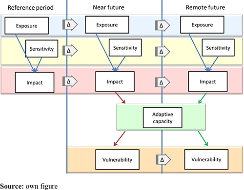
The suggested approach for an integrated vulnerability assessment to climate change is presented graphically by the following Figure 2.
For each time slice (present, near and remote future), a potential impact is determined using either only recent data (reference period) or only projections (near future, remote future). The terms “exposure” and “impact” do not describe any change in the status, but the status itself which characterizes the system at the distinct time. For the reference period, neither adaptive capacity nor vulnerability is calculated. This does not mean that there is presently no adaptive capacity, but the current capacity expresses the ability of the system to take additional actions to respond to future changes. Already implemented adaptation measures are considered under the component sensitivity. By definition, there cannot be a present vulnerability to climate change, but just an impact of the current climate.
Adaptive capacity and vulnerability only come into play when looking at the whole picture because adaptive capacity by definition only relates to the future, i.e. to the possibility of implementing additional adaptation measures. Thus, Figure 2 refers to the present adaptive capacity that matters. Those measures realized in the past, such as setting up an irrigation system to protect against climate-induced droughts, are incorporated in the assessment of sensitivity to the current climate.
Conceptually, also adaptive capacity changes over time. However, this is not reflected by Figure 2, as this figure has to be seen as framework for a GIS-based assessment. To our knowledge, there is no implementable approach to project changes in adaptive capacity between different time slices in the future. Thus, we refer to the given adaptive capacity only and handle this factor as a static component of the system. Nonetheless, there is definitely a need for further research on how to consider the dynamic aspects of this component as well.
For the overall assessment, we take into account the present, the two future time slices and the “delta” (difference) between these slices. In this way, the significance of already existing sensitivities is clarified and decisive factors for future vulnerability are identified. These factors may be triggered by changes of the climate system as well as by changes of socio-economic parameters (such as demographic change).
This leads to a modified definition of terms as explained below:
The climate signal exposure describes the exposure of today’s climate or the climate at a particular time in the future. The difference (“delta”) between the time slices describes the climate changes, such as rising temperatures, changes in precipitation and changes in weather extremes.
Sensitivity describes to what extent an existing system (a single habitat, a sector like water or a region) is sensitive to a given exposure at the considered moment. Today’s sensitivity is therefore dependent on the status quo of the system, whilst future sensitivity describes the interaction of the future system with the future climate. The delta between current and future sensitivity describes how the system changes.
Impact describes the effect of today’s climate on the current system at present and also the effect of future climate on a future system. The potential impact of climate change, as well as other change processes, can be gleaned from the difference between the current and future impact.
Adaptive Capacity is the ability of the system to adapt to climate change and to limit potential damage, and consequently, relates to the future. It therefore deals with possible preventive, damage-limiting or protective measures which go beyond steps already put in place. Adaptive capacity is to be understood as the scope of alternative actions envisaged from a current perspective in order to adapt to the expected climate change.
Vulnerability is the extent of the susceptibility of a system to the effects of climate change, taking into account climate signals, sensitivity and adaptive capacity. It allows specifying the needs for future actions and supports respective decisions. Vulnerability is the result of the comparison between the potential impacts at the different time slices as well as the capacity to adapt.
3.2 Collaborative approach
The “engine” of the project consists of a team of research consultants contracted by the German Federal Environment Agency for the period from late 2011 to early 2015. This consortium is responsible for the coordination of the whole Vulnerability Network. It ensures the continuous communication flow within the project including the organization of an initial networking conference, eight network meetings between the consortium and federal authorities and five workshops with external experts, meetings with federal state authorities and ministries as well as Federal Ministries, all this supplemented by numerous bilateral contacts via telephone, e-mail or as personal meetings. The scientists of the consortium develop and propose methodologies for the assessment and aggregation of the various components influencing the vulnerability to climate change. These proposals are discussed, if necessary modified, and finally agreed by the experts from the federal authorities in the network. The experts from the authorities support the scientists in focusing on most relevant aspects of the sectorial and cross-sectorial assessment. Moreover, they provided impacts models, data and, last but not least, their expert’s knowledge. Normative decisions are formulated by the scientists and answered by the authorities to ensure transparency. All federal authorities that potentially are relevant for engaging in climate change adaptation were asked to participate in the network. The following higher and central federal authorities participated in the network:
Federal Office for Civil Protection and Disaster Assistance (Bundesamt für Bevölkerungsschutz und Katastrophenhilfe, BBK);
Federal Agency for Nature Conservation (Bundesamt für Naturschutz, BfN);
Federal Maritime and Hydrographic Agency (Bundesamt für Seeschifffahrt und Hydrographie, BSH);
Federal Office of Economics and Export Control (Bundesamt für Wirtschaft und Ausfuhrkontrolle, BAFA);
Federal Institute for Geosciences and Natural Resources (Bundesanstalt für Geowissenschaften und Rohstoffe, BGR);
Federal Institute of Hydrology (Bundesanstalt für Gewässerkunde, BfG);
Federal Highway Research Institute (Bundesanstalt für Straßenwesen, BASt);
Federal Agency for Technical Relief (Bundesanstalt Technisches Hilfswerk, THW);
Federal Institute for Research on Building, Urban Affairs and Spatial Development (Bundesinstitut für Bau-, Stadt- und Raumforschung, BBSR);
German Agency for International Cooperation (Deutsche Gesellschaft für Internationale Zusammenarbeit, GIZ);
German National Meteorological Service (Deutscher Wetterdienst, DWD);
Federal Research Institute for Rural Areas, Forestry and Fisheries (Johann Heinrich von Thünen-Institut, TI);
Kreditanstalt für Wiederaufbau (KfW);
Project Management Agency in the German Aerospace Center (Projektträger im Deutschen Zentrum für Luft - und Raumfahrt, PT-DLR);
Federal Institute for Disease Control and Prevention (Robert Koch-Institut, RKI); and
Federal Environment Agency (Umweltbundesamt, UBA).
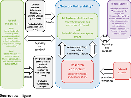
Figure 3 shows the role of the Vulnerability Network within the overall process toward a vulnerability analysis as part of the progress report of the DAS.
Figure 3 shows a rather complex system of information and communication flows within and around the Vulnerability Network. The main interactions are described as follows:
Within the Network between the federal authorities and the research consortium: The exchange, advice and support between the federal authorities and the research consortium was organized along milestones and institutionalized by so-called network meetings that took place every three to eight months, depending on the progress within the project and the need to agree on (normative) decisions, e.g. on thresholds or weighting issues. Further, the experts from the authorities were contacted in bilateral interviews.
Within the Network between the research consortium and the contracting agency (UBA): There was a regular information and communication flow between the contracting agency and the research consortium (telephone conferences, bilateral contacts), as well as within the consortium (telephone conferences).
Between the Network and external experts: additional expertise was integrated through a series of five workshops with external experts, expert papers and several dozens of interviews.
Between the Network and other authorities: The approach and interim results were reported to the Interministerial Working Group on climate change adaptation and representatives of the Federal States (Bundesländer) to increase the transparency of the process and acceptance of the methodological approach and the results. A regular newsletter service also served to inform interested parties including federal authorities and federal state authorities outside the Network.
4. Preliminary results and further analysis
The Vulnerability Network is work in progress and the final GIS-based outcome of the vulnerability assessment is not available yet. Thus, the following section concentrates on preliminary results, which have not been verified in every detail within the Vulnerability Network. Here, primarily, the methodological innovations of the Vulnerability Network are outlined.
In close cooperation between the consortium and the federal authorities, the so-called impact chains were developed to identify most relevant potential impacts of a changing climate in the various sectors. For this purpose, discussions were organized in specific expert workshops covering thematic clusters of these sectors and involving experts from federal authorities as well as external experts nominated by the network. Within the scope of these expert workshops, the research consortium received input concerning the impact chains, as well as concepts, models and indicators, for assessing the relation between climate signals (exposure), sensitivity aspects and the resulting impact. In parallel, the consortium developed in coordination with the federal agencies an overall methodological approach for the generation of spatially explicit analyses of vulnerability and its components. The next steps included a selection of the most relevant potential climate change impacts by the network partners, which guided the research consortium in focusing its work. Subsequently, the consortium proceeded with the various assessment steps as defined in the methodology agreed, supported by the federal authorities in the network partners, especially through the provision of data and expert’s knowledge.
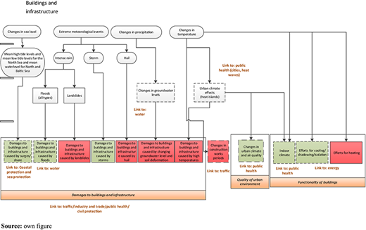
In the following, as an example, the impact chain for the “buildings and infrastructure” sector is shown. This sector is one of the 15 sectors which are covered by the DAS. Figure 4 indicates the interrelationship between climatic stimuli, direct impacts of climate change (e.g. on floods) and second-order effects on buildings and infrastructure. This figure provides a first overview about the expected impacts of climate change on the building sector. The sensitivities are not explicitly covered at this stage, but will be explained in detail in the next section of this paper.
As clearly visible from this figure, there are three main impact clusters: damages to buildings and infrastructure caused by changes in extreme events, changes in the quality of the urban environment and finally impacts on the functionality of buildings. Within these clusters, individual impacts were identified and selected by the Federal Authorities based first on the potential relevance of the impacts of climate change on the building sector and second from a cross-sectoral perspective. Only selected impacts (indicated by the green boxes in Figure 4) were parameterized in the next assessment step.
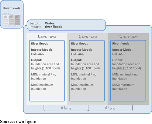
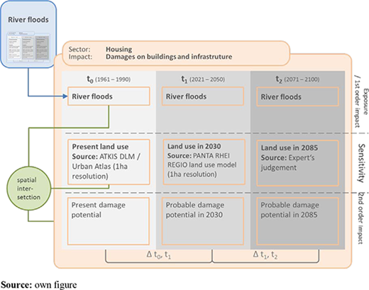
The next step is to assess these potential impacts of climate change in detail. Figures 5 and 6 explain the methodological concept for this assessment by the example of changes in frequency and magnitude of river flooding as direct impact of climate change and related second-order impacts on the housing sector.
For all three time slices (reference period, near and remote future), the outputs from the LISFLOOD model are available which cover already relevant climatic stimuli and calculate the first-order impact (changes in river floods) (Dankers and Feyen, 2009). The available outputs reveal inundated areas for the 1:100 return period for the present and future climatic conditions. The information is available on grid cell basis (100 × 100 m) for 12 climatic models and covers the entire country (actually the whole of Europe).
However, tools such as the LISFLOOD model are not available for each impact to be scrutinized. In the cases where models are lacking, proxy indicators will be used for calculating exposure and sensitivity which are linked together based on scientific findings from available literature (Schmidt-Thomé and Greiving, 2013).
The information on inundated areas and inundation heights derived from the LISFLOOD model is a relevant input parameter for calculating the impact of changes in river flooding on the housing sector (as well as for many other impact chains) as shown by Figure 6.
The first-order impact “changes in river flooding” is used as an input parameter for calculating the impact of river floods on housing. Here, no impact model is available. Therefore, a proxy indicator (number of houses located in inundated areas) was defined for assessing the sensitivity to river floods In contrast to the output of the LISFLOOD model, which is available for all three time slices, different data sets have to be used for calculating the sensitivity of the housing sector to changes in river floods:
Land-use (ATKIS DLM) and Urban Atlas data offer information about the current land use with a resolution of 100 × 100 m.
The land use pattern in the near future will be projected through a land use model (Panta-Rhei-Regio) (BBSR, 2012). This model offers data about potential land use patterns in 2030 with a resolution of 100 × 100 m (1 ha).
No quantitative data are available for the remote future. Here, a qualitative judgment will be used for assessing the pattern of future land use. The spatial reference is envisaged to be at regional level (NUTS 2).
Each of the described steps will be done for the three ensemble members, as well as the two socio-economic scenarios, to reflect the given bandwidth of potential future conditions. Moreover, the vulnerability assessment will be done in a similar way for almost all sectors, respectively those impacts of climate change on these sectors which have been prioritized by the entire network (84 in all).
5. Conclusions
The main prerequisites for developing a consistent methodology for vulnerability assessment are a consistent terminology and a consistent methodological, as well as a sound conceptual base. This paper illustrates that these requirements are rarely met in current practice. The most serious challenge for an estimation of the vulnerability of a specific region to climate change in general and for the Vulnerability Network in particular is to manage the necessary projection of future sensitivity-related data in sufficient spatial resolution. The work within this project of the current and upcoming year (2014 and 2015) will enlighten the extent to which this is possible.
First attempts have been made to overlay regional climatic and demographic projections for Germany (Greiving, 2012). The results indicate that considerable adaptation is necessary, especially for areas where climate stimuli are changing significantly and the sensitivity of which increases due to a population incline (in particular in the Upper Rhine valley and the foothills of the Alps). Nevertheless, the projection of socio-economic factors is inevitably related to a high degree of uncertainty. This does not alter the fact that any projection in this context will be more appropriate than the use of recent data. In the absence of reliable data, one might have to resort to plausible scenarios. To be more precise in the terminology, vulnerability assessments based on climate and sensitivity scenarios should be called vulnerability scenarios. The question whether all results obtained from a vulnerability assessment developed in this way can also be quantified and represented graphically for each separate area, will be answered by the future work within the Vulnerability Network.
Overall, the experience made so far with the project design that closely links a scientific consortium with Federal Authorities for assessing vulnerabilities to climate change is very encouraging. The Vulnerability Network was able to create a rapidly growing network of partners which actively participate in the on-going project tasks. This success is doubtlessly supported by the fact that the planned project objectives directly support the current work of the federal authorities within their climate change-related activities. The new approach of a closer cooperation of science and federal authorities is perceived positively by project partners from both science and administration, but, on the other hand, it leads to prolonged decision procedures. However, the time spent for consensus building is well invested, as it lowers barriers for actions to be implemented by a manifold of actors. Still, the effort to keep the large number of network partners up-to-date, to maintain their interest and motivation, to participate and to communicate and explain tasks and requirements to all partners involved should not be underestimated.
References
Further reading
About the authors
Stefan Greiving is Executive Director of the Institute of Spatial Planning at Dortmund University of Technology. In addition, he is founder and partner of the consultancy company Plan + Risk Consult, based in Dortmund. He graduated from Dortmund University of Technology in 1995 and obtained his PhD in 1998. Prof Greiving is specialized in spatial planning, risk management and climate change adaptation, vulnerability and risk assessments. Stefan Greiving is the corresponding author and can be contacted at: stefan.greiving@tu-dortmund.de
Marc Zebisch is the scientific head of EURAC’s Institute for Applied Remote Sensing. He graduated at the Potsdam University (Institute for Geoecology) and obtained his PhD at the Technical University of Berlin (Institute for Landscape Development) in 2004. He is specialized in monitoring and modeling land-use dynamics and the consequences of global change by means of remote sensing, GIS and computer models.
Stefan Schneiderbauer is Head of the Group “Risk, Vulnerability and Climate Change” within the Institute for Applied Remote Sensing. He graduated at the Institute for Geography of the Cologne University (Germany) in 1993 and obtained his PhD from the department for geosciences of the Free University Berlin (Germany) in 2007. He is specialized in integrated vulnerability and risk assessments to natural hazards and in climate change impacts.
Mark Fleischhauer is Senior Reseacher at the Institute of Spatial Planning at Dortmund University of Technology and partner of Plan + Risk Consult. He studied Geography at the University of Hannover and Spatial Planning at the Dortmund University of Technology, and holds a PhD in Spatial Planning. Dr Fleischhauer is specialized in disaster risk management and climate change adaptation, vulnerability and risk assessments.
Christian Lindner is Senior Researcher at the Institute of Spatial Planning at Dortmund University of Technology and partner of Plan + Risk Consult. He studied Spatial Planning at the Dortmund University of Technology and holds a PhD in Spatial Planning. Dr Lindner is specialized in GIS and DSS applications and vulnerability and risk assessments.
Johannes Lückenkötter is Senior Researcher at the Institute of Spatial Planning at Dortmund University of Technology and partner of Plan + Risk Consult. He studied Spatial Planning at the Dortmund University of Technology. He is specialized in planning in developing countries, disaster risk management and climate change adaptation, vulnerability and risk assessments.
Mareike Buth studied human geography and environmental management. She works as project manager at adelphi and is specialized in topics such as vulnerability to climate change and adaptation strategies. She supports the Vulnerability Network organizationally as well as in terms of content and concepts.
Walter Kahlenborn is a co-founder and Managing Director of adelphi, a Berlin-based environmental policy consultancy. Walter Kahlenborn studied industrial engineering (Dipl.-Ing.) and history and philosophy (MA) in Berlin, Bologna and New Orleans. One of his focus areas is climate change adaptation and vulnerability to climate change.
Inke Schauser studied Applied Physical Geography and holds a PhD in Limnology. Since 2008, she is an adaptation policy advisor in the Department of Climate Change Impacts and Adaptation (KomPass) at the Federal Environment Agency, Germany. In this function, she has developed the concept of the Vulnerability Network and coordinates it.
The work was conducted within the project “Netzwerk Vulnerabilität” (Z 6 – 50 205 5/10) funded by the German Federal Environmental Agency.

