The Thames Tideway Tunnel project is a deep tunnel system for combined sewer overflow control in London, UK, to improve the health of the tidal River Thames. This paper reports on how the scheme was developed to minimise its impact on the river while also seeking to utilise the river to minimise the impact of the scheme on London’s residents and creating new public realm that fits seamlessly into the river vista and promote the reconnection of Londoners to their river.
1. Introduction
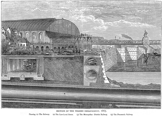
London’s sewerage system was significantly improved by Sir Joseph Bazalgette between 1859 and 1875, who started the process of cleaning up the tidal River Thames as a solution to the Great Stink of 1858. The sewers were designed to capture rainwater and sewage from around four million people. To prevent sewage backing up and flooding people’s properties, a failsafe was incorporated, which allowed the subsystem to overflow into the river by way of 57 combined sewer overflows (CSOs) located along the banks of the Thames. Sir Joseph Bazalgette changed the shape of the river by building the Chelsea, Victoria and Albert Embankments. The Victoria Embankment not only housed an interceptor sewer, but also included a services gallery and an underground railway (now the District and Circle Underground lines) (see Figure 1 and Skilton (2007)).
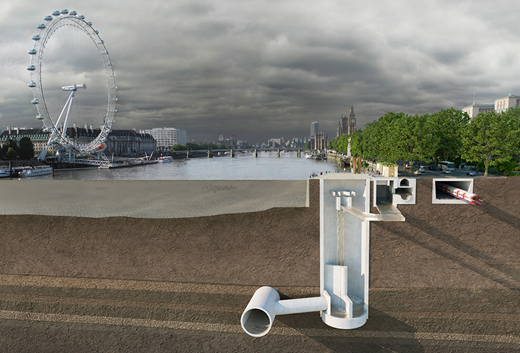
The Thames Tideway Tunnel project is the latest scheme to be constructed to clean up the Thames by intercepting the 39 million m3 of untreated combined sewage that entered the river in a typical year. The project actively manages and controls CSO discharges from the 34 most polluting CSOs and diverts flows into a tunnel storage and transfer system for treatment at Beckton Sewage Treatment Works. More information on the purpose and design aspects of the project is provided by Grant and Bailey (2025) and Fricker et al. (2025), respectively (both in this issue). The cross-section at the Victoria Embankment Foreshore site (Figure 2) illustrates Bazalgette’s railway line box and interceptor sewer/services gallery (to the right) alongside the new CSO interception chamber, drop shaft containing a vortex drop, connection tunnel and main tunnel (to the left).
The project was developed to be sensitive to the unique nature of the River Thames, with its tidal range and flows and historic architectural features, while also being mindful of its users as a commercial and recreational waterway.
The potential impacts of the construction on residents and businesses, both surrounding the sites and on the main access routes, were also carefully considered. It was predicted that over 8 Mt of materials would need to be transported, either to or from the sites, during construction, with around 3 Mt of material being excavated for the main tunnels alone. A review of the impact of the number of heavy goods vehicles (HGVs) required to transport the materials, particularly to support the tunnelling, led to a commitment by Tideway to transport at least 4.2 Mt of materials by river and to work with the contractors to increase this where possible.
This paper presents information about the principles of the in-river site shape development, the impact of river transport on the delivery of the project, the engagement with the river marine industry to mitigate risks and the impact that the new foreshore structures will have in the years to come.
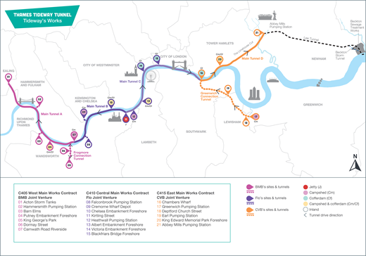
The River Thames was used to transport materials from and to 12 sites by either jetty, campshed or cofferdam (Figure 3). The shape of the river has been changed, with new public realm at seven sites: Putney Embankment Foreshore (04 in Figure 3), Chelsea Embankment Foreshore (10), Heathwall Pumping Station (12), Albert Embankment Foreshore (13), Victoria Embankment Foreshore (14), Blackfriars Bridge Foreshore (15) and King Edward Memorial Park Foreshore (20).
2. Foreshore structure shape development
A multi-disciplinary site selection process was undertaken to identify the location of the CSO interceptions, resulting in seven sites with interception works in the river. The footprint of the encroachment into the river was minimised, with the size and shape of the in-river permanent structures determined by the infrastructure contained within and its position with the Thames cityscape, minimising change to characteristics of the tidal flow and maximising its impact for connection of the public with the river.
For example, the Victoria Embankment Foreshore/Tyburn Quay site is located on Victoria Embankment, just upstream from Hungerford Bridge. Victoria Embankment, constructed as part of Sir Joseph Bazalgette’s scheme and opened to the public in 1869, is Grade II listed and is located within the Whitehall conservation area, which comprises a number of listed buildings of international importance and various statues and monuments. The site is located in a number of key views identified in the Mayor of London’s View Management Framework and forms part of the setting to the Palace of Westminster – a United Nations Educational, Scientific and Cultural Organisation World Heritage Site. The River Thames itself is a site of importance for nature conservation. It is also close to Embankment Pier and prominent in views from the London Eye and Jubilee Gardens on the south side of the Thames.
Due to the scale of the project, the number of new in-river permanent structures and the extent of the associated temporary structures that would be required, HR Wallingford (HRW) was engaged to undertake extensive studies on the fluvial flows of the Thames. The first stage was site-specific numerical modelling using HRW’s whole Thames estuary two-dimensional (2D) numerical modelling. However, it became apparent that there needed to be a more detailed examination, particularly in relation to 3D flows, the generation of eddies and local turbulence.
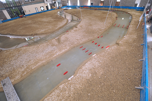
HRW was therefore commissioned to carry out physical model studies of three of the sites – King Edward Memorial Park Foreshore, Victoria Embankment Foreshore/Tyburn Quay and Blackfriars Bridge Foreshore/Bazalgette Embankment. The physical model to support the studies is shown in Figure 4.
The 3D physical model study was designed to imitate the flow in the tidal Thames and allow optimisation of the proposed structures. At a scale of 1:100, changes of river/tidal currents, river morphology and scour impact on structures could be measured and/or assessed, together with the impacts the works would have on barge and river traffic. The physical modelling was therefore used to determine the effects that the temporary and permanent works, at the three locations, would have on tidal river flows, the wellbeing of the river environment and riparian activity.
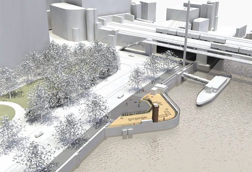
Initial options considered for the Victoria Embankment Foreshore/Tyburn Quay site included curved river walls (Figure 5), which would have been more beneficial in minimising the impact on the fluvial flows in the area. However, these were unacceptable to stakeholders on the grounds of cultural heritage – the new structure should be designed to be sympathetic to other ‘monumental’ extensions into the river along the Victoria Embankment that are rectangular, such as the stairs in front of Cleopatra’s Needle and the Whitehall stairs. The regulators needed reassurance that the impact of the more rectangular structures desired by the local authorities would not prove detrimental to the fluvial flow or the stress on the riverbed materials. The physical fluvial model provided the information required to demonstrate that the impacts were within acceptable levels.
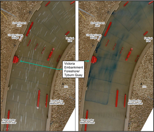
Figure 6 shows HRW’s dye float testing of the rectangular foreshore design. At other sites, such as Blackfriars Bridge Foreshore/Bazalgette Embankment and Albert Embankment Foreshore/Effra Quay, the ‘corners’ of the foreshore structures were rounded.
3. Construction
3.1 Access to sites from the river
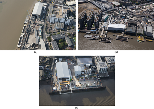
One of the main constraints when considering servicing the 12 riparian sites during construction was the ability to access the sites from the river due to the 6 m tidal range of the Thames. The tidal range meant that there were only two sites with continuous access for barges without additional infrastructure being required – Victoria Embankment Foreshore/Tyburn Quay and Blackfriars Bridge Foreshore/Bazalgette Embankment. The selection of additional infrastructure at the other nine sites was dependent on logistical requirements, such as whether the amount of material being removed from site, or required by the site, would need continuous servicing or if the production rates were such that a vessel could be loaded or unloaded over low tide without causing a delay to the works on site. At the three main tunnel drive sites (Carnwath Road Riverside, Kirtling Street and Chambers Wharf), which had the greatest demand for river transport, three different solutions were used (Figure 7).
The main works contractor for the west section of the project – a joint venture between Bam Nuttall, Morgan Sindall and Balfour Beatty – strengthened the river wall to allow the construction of a ‘not always afloat but safely aground’ (NAABSA) berth at Carnwath Road Riverside. Even with a jetty at the site, a campshed would have been required. This NAABSA berth was used in conjunction with a conveyor system that could load vessels at a rate such that they could be loaded over the high water, while the segments were generally delivered on a pontoon and unloaded over the rest of the tide.
The main works contractor for the central section – a joint venture between Ferrovial Construction and Laing O’Rouke – constructed a jetty and in-river berth at Kirtling Street, which allowed the mooring of barges to be loaded with a radial conveyor and a separate pontoon to receive the incoming segments.
The main works contractor for the east section – a joint venture between Costain, Vinci Construction Grands Projets and Bachy Soletanche – constructed a large cofferdam into the river at Chambers Wharf, which allowed barges to remain afloat, while also increasing the size of the site to provide sufficient space for the equipment to support the tunnelling.
The project’s Development Consent Order (DCO) (HMG, 2014) constrained the construction of the temporary works for the CSO interception sites by defining maximum extents within which the cofferdams needed to be located. This envelope led to a combination of twin-wall cofferdams, combi pile cofferdams and NAABSA berths. The method selection at each site was dependent on the site location, existing infrastructure, the permanent works construction method, the space required for the construction of the new permanent structures and the transfer of materials through the site.
The majority of the CSO interception sites made use of a twin-wall cofferdam, with some part of the structure providing a working platform to house temporary office set-ups, cranes for the transfer of materials and storage areas. Where combi pile walls were used, the support for lifting and transfer of materials was provided by crane pontoons, jack-up barges or a small tower crane.
3.2 Use of river transport
As outlined earlier, Tideway committed to using river transport to support the construction of works to reduce the impact on residents and businesses surrounding the sites, while also reducing the impact on London’s roads and the residents that live on, or near, the routes running to and from the sites. Working with stakeholders from the riparian local authorities, the Port of London Authority (PLA), the Greater London Authority and Transport for London (TfL), Tideway developed a River Transport Strategy (Tideway, 2023), which enshrined the commitment to transport specific materials by river as well as working with the contractors to maximise the use of the river where possible. The strategy also defined the process that needed to be followed to demonstrate compliance, as well as to allow construction to continue should access from/to the river be restricted.
The initial submissions from Tideway’s contractors indicated that there would be approximately 4.5 Mt of specified materials (tunnel arisings, shaft arisings, primary lining segments transported to Chambers Wharf and cofferdam fill), with an additional 0.45 Mt of materials made up of 100% of primary lining segments to be transported to Kirtling Street and 50% of primary lining segments to be transported to Carnwath Road Riverside.
Following contract awards, the contractors were required to consider further use of the river. From this process, the contractors identified – and committed to – an additional 200 000 t of materials to be transported by river. These materials were tunnel arisings from the Greenwich connection tunnel, 100% of primary lining segments transported to Carnwath Road Riverside and additional materials into Blackfriars Bridge Foreshore and Victoria Embankment Foreshore, bringing the overall commitment by river to about 5.15 Mt.
During the development of the DCO, there was limited data available from the Department for Transport about emissions from vessels, particularly the tugs that are used in and around the River Thames. Tideway took the opportunity to undertake an emissions study, which increased knowledge of the impacts of using river transport on the Thames in comparison to road transport. A comparison of moving excavated materials from a project worksite to a receptor site by both HGV and barge was carried out, measuring the emissions. Several monitored runs of a tug were undertaken to consider the different scenarios of loaded and empty barges, as well as running against and with the tide to ensure that a representative average was obtained. The outcome of the monitoring demonstrated that a tug towing a barge carrying 1000 t running at 75% engine load will, when compared with HGVs, produce
90% less carbon dioxide
95% less carbon monoxide
86% less nitric oxide and
54% less nitrogen oxides.
When compared with a fleet of Euro VI HGVs carrying the equivalent cargo, the benefits to air quality improved as the size of barge increased. This work created a useful dataset to clearly demonstrate the benefits of using the river as an effective, efficient and environmentally beneficial form of transport (Tideway, 2019).
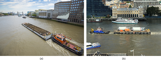
It was estimated that the total quantity of materials transported by river to support the construction of the main tunnel, connection tunnels and CSO interception sites would be around 5.9 Mt. This was 1.7 Mt more than the initial DCO target of 4.2 Mt and 1 Mt more than the original offer provided by the contractors as part of the tendering process. Therefore, the approach to maximise the use of the river had been very successful. Figure 8(a) shows a tug pushing the tunnel arisings (as required by the DCO) and Figure 8(b) shows a tug towing cement silos (as additional materials).
Transporting the 5.9 Mt of materials by river prevented over 350 000 HGVs from having to be on London’s roads, which would have created over 700 000 HGV movements. This, in turn, removed over 17 million HGV miles with associated reductions in wear and tear on the highways, reductions in the levels of particulates and gases being expelled, noise reduction and reduction in risk to vulnerable road users. In addition, using the findings of the emissions report, there was a saving of over 16 000 t carbon dioxide equivalent when compared with transport of the materials by road.
The excavated material from tunnelling was required to be beneficially reused as part of the project’s sustainability objectives. The contractors were able to engage with opportunities within the River Thames estuary to support a habitat creation scheme as an extension to the RSPB Rainham Marsh site, as well as enhancing the capping at a historic landfill site at Goshems Farm, Tilbury. Further information on this is provided in this issue (Sage, 2025).
3.3 River transport risk mitigation
During the development of the River Transport Strategy, it was recognised that Tideway needed to understand the marine industry along the River Thames. This information was required to confirm there would be sufficient capacity within the market to transport the quantities of materials at the rates required, with a focus on the transportation of tunnel arisings as the peak output activity. It was also recognised that, while the approach to river use was to reduce the overall risk to vulnerable road users, it was important that it did not just transfer the risk from vulnerable road users onto river users. It was predicted there would be a trebling of existing commercial river traffic, so there was the potential risk, with serious consequences, of a collision between a tug towing materials on behalf of the project and a passenger vessel, which can carry up to 500 passengers.
Tideway engaged with the recreational, commercial and regulatory stakeholders of the Thames to better understand the key risks for day-to-day river operations, while also seeking to have a positive impact on the local industry, such as by increasing the operational standards and providing the opportunity for the industry to demonstrate what the advantages are of using river transport over road transport, resulting in an important legacy for the river industry.
One method to mitigate the risks was the production of a Code of Practice for Marine Operations (CoPMO), which was developed in consultation with river stakeholders while also being independently reviewed. The CoPMO was included as part of the Works Information (which form a part of Tideway’s NEC3 main works contracts (NEC, 2013)), so the actions had to be complied with as part of the contract. The principal mitigations within the CoPMO were the use of the International Safety Management (ISM) Code (IMO, 2015) and the validation of boat master competency.
3.3.1 ISM code
Following consultation with the Maritime Coastguard Agency (MCA) and the PLA harbour masters about tools available for marine operators, it was determined that compliance with the ISM Code would be most appropriate for the higher risk operators carrying out towing and pushing operations.
The ISM Code – a code for the safe operation of ships and pollution prevention – is an internationally recognised framework of principles and objectives that helps to assess the risks to vessels, personnel and environment, and establish appropriate mitigations. It is a requirement of the International Maritime Organization for vessels over 500 gross tonnage to operate in accordance with the ISM Code. The requirement by Tideway for tug operators (higher risk operators) to operate in accordance with the ISM Code – even though their vessels were less than 500 gross tonnage – was viewed by the MCA as applying the code under a voluntary basis.
In the UK, the ISM Code requires a company to demonstrate to the MCA that it has appropriate procedures in place to protect crew members, vessels and the environment. These processes include assurance regimes to ensure that all staff and vessels are adhering to the company’s policies and procedures. These systems also have the positive effect of allowing crews to feed back into the system to suggest improvements. Following a successful inspection from the MCA, a contractor would receive a document of compliance for the company and a safety management certificate for each qualifying vessel.
3.3.2 Boat masters’ competency validation
From studies into the river workforce undertaken by Tideway, it became apparent that there might not be sufficient capacity in the market to support the enhanced level of river use required by the project, in conjunction with the existing operations. One concern was that there may be tug masters who had not operated for some time, due to the decline in commercial river traffic over recent years, that could return to the industry and not be able to perform to more recent standards. To mitigate this risk, Tideway established a programme to validate tug masters’ competencies, against the required syllabus, to ensure that any master operating on behalf of Tideway demonstrated their competency and exhibited good behaviours.
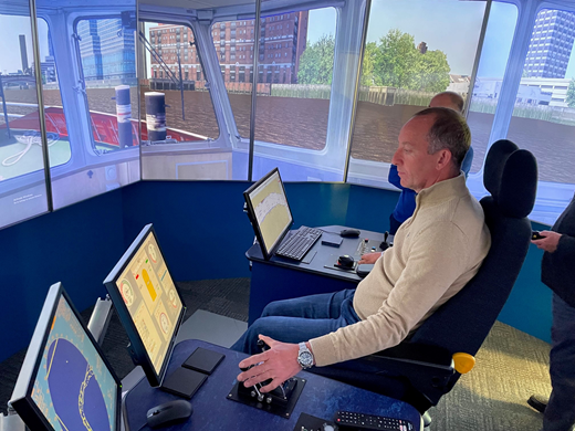
Following a competitive tendering process, Tideway engaged HRW to develop a validation course using their ship simulation centre. The final course required the masters to undertake exercises over a period of 3 days, which ensured they covered all the components of the syllabus required for a tug master. The course also allowed the masters to demonstrate their awareness of their employer’s safety management system and put them through unexpected scenarios and emergency situations in a safe, risk-free environment.
The simulator uses HRW’s hydrodynamic model, which is built from tide gauge data and flow measurements along the Thames to simulate realistic flow and tide conditions on the river. In addition, HRW’s naval architects developed a suite of realistic ship manoeuvring models for the vessels used in the simulation. The Thames simulation is the most detailed visualisation HRW has developed to date, and includes details such as the lions’ heads in the river embankments, marker posts and even details on the undersides of bridges due to the importance of visual cues while navigating on the Thames (HRW, 2021). The realism of the model can be seen in Figure 9.
To continue the development of marine training and ensure that there would be sufficient river personnel to deliver the project and for the future of the Thames industry, Tideway worked in collaboration with the PLA, TfL and the Company of Waterman and Lightermen to deliver a training organisation.
The Thames Skills Academy (TSA) is a group training organisation that built upon earlier work carried out by Thames operators who were concerned about the quality of training that was being delivered and the difficulty in achieving funding to support high-quality training. Riverside personal safety was the first course developed by the TSA in partnership with Tideway’s contractors to mitigate the risk of having large numbers of the workforce operating around the river and the foreshore. The course was developed to inform workers about the river environment, highlighting the risks, while also providing practical experience in a pool to practise the use of rescue equipment and experience a self-inflating life jacket. This course received the City and Guilds Princess Royal Training Award in recognition of its quality and has been adopted on a number of other projects to minimise risks to staff.
4. Riverscaping the public realm
Encroachment into the River Thames is highly discouraged due to loss of ecological habitat, increases in flows, higher water levels and potential for flooding. Therefore, foreshore structures were constructed only where no site on land could be identified, and the footprint of the encroachment was kept to a minimum. However, where it was necessary to build into the Thames, the structures provided valuable opportunities for new areas of riverside publicly accessible open space in London’s largest open space – the River Thames. Provision of public space adjacent to, and with views across, the river is highly prized by Londoners.
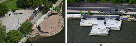
The design of each riverside site was developed to respond positively to the riverscape, character and context of each location. Contrast, for example, the monumental geometry at Victoria Embankment Foreshore/Tyburn Quay with the smooth, curved lines of the structure at Chelsea Embankment Foreshore/Chelsea Quay, as shown in Figure 10. Similarly, the materials selected to clad the river walls were selected for each location. At Chelsea, the bricks of the pre-Bazalgette river wall, along with the quality of the curved brickwork within the sewers themselves, were the inspiration for the choice of materials for the river wall (Figure 10(a)), whereas granite was chosen when interfacing with the Victoria Embankment (Figure 10(b)). All materials were selected for their durability and impact resistance.
Opportunities to further enhance aquatic ecology through the design of the foreshore sites were explored where possible. The sites at Chelsea Embankment Foreshore/Chelsea Quay, Albert Embankment Foreshore/Effra Quay, King Edward Memorial Park Foreshore, Chambers Wharf and Dormay Street all include intertidal terraces – new areas of marginal habitat in the heavily culverted estuary (see Donnelly et al. (2025) in this issue).
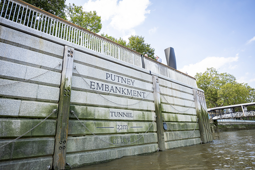
Views of the foreshore structures for river users were also considered as part of the river wall designs. The place name of each site is included in the river wall cladding. Horizontal lines and markers, inspired by plimsol lines and high-water marks, provide a datum, with the depth of the tunnel below given to subtly draw attention to the structure as being part of the Thames Tideway Tunnel system. A good example of these features is presented in Figure 11.
Safety features such as fenders, navigation lights, buoyancy aids, safety chains and ladders are incorporated into the design of the public realm and river walls. Balustrades and guardrails are designed to prevent accidental falls into the river, while maximising views of the river from the new spaces accessible to the public.
5. Conclusions
At its most basic concept the Thames Tideway Tunnel project was constructed to ensure that London’s sewer network complies with the urban waste water directive (EC, 1991). Combined sewage flows have been intercepted and transferred for treatment instead of passing through Sir Joseph Bazalgette’s historic CSO outfalls into the river whenever London’s combined sewers were overwhelmed following rainfall. The difficulty was to undertake these works on 21 sites across London while trying to minimise the impacts of the construction but maximise the benefit to Londoners.
The development of the CSO interception sites, requiring new realm in the river, needed extensive consultation work with the principal river and riparian local authority stakeholders. The aim was to ensure that the final structures would be sympathetic, or enhance the surroundings, while minimising the impacts on the river and its users during construction and in the operational phase when all of the works had been completed.
By embracing the use of river transport to support the construction of the project, Tideway and its contractors demonstrated that the river is a viable, sustainable and reliable mode of transport for large-scale infrastructure. This ranged from high-volume works such as servicing of the tunnel drive sites to supporting smaller scale works such as those at the project’s foreshore sites. The key to using the river was the extensive engagement with the industry and stakeholders during the development of the scheme to provide an overview of what would be required to safely deliver the works. Through the early identification of risks from this consultation, the project has raised the bar for safety in the near term while also putting into place arrangements to support continued improvements for the marine operators and contractors that will work in or around the River Thames in the long term.
Acknowledgements
The authors would like to acknowledge the full engagement of all river operators working on the Thames Tideway Tunnel project and their steps in changing the culture for improving safety on the Thames.