

Minor, shallow landslides have occurred frequently on the island of Singapore. However, very few major landslides (greater than 10 m in height) have occurred. Slope failures in the sedimentary Jurong and granitic Bukit Timah formations have occurred largely on slopes with angles greater than or equal to 27°. It is clear that rainfall has been the dominant triggering event for landslides in Singapore. Observations of past landslide events suggest that a total rainfall of 100 mm within a six-day period is sufficient for minor landslides to take place. The equivalent condition for major landslides would appear to be 320 mm within 16 days but this is based on very limited data.
1. INTRODUCTION
Minor, shallow landslides have occurred frequently on the island of Singapore, particularly as urban development has greatly increased since the 1970s.1 Very few major landslides have occurred although details of nine major landslides are tabulated in this paper. Also in this paper, some observations are made of the slope angles at which failure has been observed. In addition, the rainfall patterns preceding landslide events in Singapore have been examined to identify the amount of rainfall that would be expected to lead to landslide occurrence.
2. THE CLIMATE AND GEOLOGY OF SINGAPORE
The climate of Singapore is hot and humid all year round. The temperature varies little throughout the year with an annual average temperature of 26·6°C. The average annual rainfall in Singapore varies between 1600 mm and 2500 mm.2
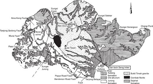
Tropical residual soils cover almost two-thirds of Singapore Island. They are derived mainly from the weathering of the sedimentary Jurong and granitic Bukit Timah formations (Fig. 1). The Jurong residual soils exist as interbedded layers of predominantly medium plasticity clayey silt, sandy clay and clayey to silty sand materials.3 The Bukit Timah residual soil varies from silty or clayey sands to silty or sandy clays (depending on the degree of weathering) but is commonly sandy clayey silt.4 Some shear strength properties of the residual soils of Singapore are summarised in Table 1. For the Jurong soils, average values for ϕ′ are normally 27–35°. For the Bukit Timah soils, average values are 30–32°.
Summary of shear strength parameters for Singapore residual soils
| References | Geological formation (location) | Description | Depth range: m | Effective cohesion, c′ (kPa) Average (range) | Effective angle of friction, ϕ′ (°) Average (range) |
|---|---|---|---|---|---|
| 6 | Jurong (NTU Campus) | Sandy silty clay | 1·25–7·45 | 31 (19–50) 15 tests | 27 (24–40) 10 tests |
| 7 | Jurong (NTU Campus) | Silty clay | 0·2–0·5 | 95 1 test | 35 1 test |
| 8 | Jurong (NTU Campus) | Silty clay | 0·2–0·5 | 20 (15–22) 4 tests | 27 1 test |
| 9 | Jurong (Pulau Ayer Chawan) | Sandy clayey silt | 12 18 tests | 35 18 tests | |
| 9 | Jurong (Pulau Pesak and Pulau Seraya) | Clayey silt | 17 36 tests | 28 36 tests | |
| 10 | Jurong | Weathered sandstone | 6 | 32 | |
| 10 | Jurong | Shale | (20–25) | (20–26) | |
| 11 | Jurong | Sandstone/ siltstone boulders, cobbles and gravel in a silty clay matrix | (5–100) | 28 (17–46) | |
| 11 | Jurong | Silty clay/clayey silt | (10–65) | (17–36) | |
| 12 | Gombak Norite (Bukit Batok) | Clayey silt/ sandy silt | 0–16 | 11 (3–33) 100 tests | 36 (25–45) 100 tests |
| 13 | Bukit Timah (Lorong Terigu) | 0–21 | 15 (0–40) 7 tests | 32 (30–35) 7 tests | |
| 11 | Bukit Timah | Silty clay/clayey silt | (0–125) | 30 (13–36) | |
| 5 | Bukit Timah | Sandy silty clay/sandy clayey silt | (0–42) 17 tests | (20–36) 12 tests |
3. SLOPE HEIGHTS AND SLOPE ANGLES
A small number of major landslides (greater than 10 m in height) have been reported in Singapore. A brief description of each of these landslides is given in Table 2.
Summary of major landslides in Singapore
| Landslide | Date | Height | Angle | Comments | Ground conditions | References |
|---|---|---|---|---|---|---|
| Tanjong Gul | Pre 1972 | 25 m | 30° | A benched cut slope. The slide took place in the upper part of the slope and affected about 60 m of the slope length. A vertical backscarp of about 2 m was formed and bulging took place at the toe | Volcanic agglomerate, and shale and residual soils. The rocks were dipping steeply in the same direction as the cut | 1 |
| Hillview Estate | 1982, 1983, 1984 | 22 m | 13·5° | The first major mass movement started in December 1982 due to fracture of a water pipe, possibly caused by earlier minor movements. Further major movements occurred in March 1983 and March 1984 during heavy rainfall. The landslide involved about 50 000 m3 of material | Residual soils derived from Gombak Norite and colluvium with some recent deposits (Kallang formation) being found at the toe. Failure probably occurred very close to the contact between the residual soil and the underlying weathered norite | 1 |
| Depot Road | 1978, 1984 | 40 m | 29° | A slope on the northern ridge of Mount Faber. A shallow slip occurred mid-slope in December 1978. The slope was originally benched. A major slide (in the form of a flow) occurred in March 1984 after a period of heavy rainfall | The crest of the slope was fill material. The failure occurred in the bench and resulted in disaggregation of the fill material which then developed into a debris flow14 | 1 |
| Fort Canning | 1984 | 40 m | 34° | Occurred in Fort Canning Park during heavy rain in March 1984. The failure surface was shallow, about 3 m below the ground surface, but about 1500 m2 of the slope started to move. Ground anchors were used to stabilise the slope | Residual soils (Grade VI) formed from the sedimentary Jurong formation | 1 |
| Gillman Heights | 1985 | 17 m | 34° | A cut slope for the Ayer Rajah Expressway at Gillman Heights showed signs of instability in December 1985. The slope was stabilised using soil nails | Medium dense to dense residual soils (Grade IV and V) derived from the sedimentary rocks of the Jurong formation | 1 |
| Admiralty Road | 1987 | A road cutting. The slope had been recently cut and graded during road widening. The initial failure occurred during a nine day wet period with a total rainfall of 413 mm. The slope failed in five places, two of which involved the whole length of the slope. The slope was regraded but failed repeatedly, each time after a period of heavy rainfall | Fill material of weathered granite overlying deeply weathered in-situ granite | 6 | ||
| Lorong Terigu | 24 m | 27° | This is part of the cut slopes formed during the construction of the Bukit Timah Diversion Canal. Since construction in the early 1970s a number of slips have occurred along the canal length with Lorong Terigu being the largest. The slip surface was found to be 5 to 6 m below ground surface at its deepest point | Loose to medium dense clayey silt near the surface, becoming very dense below 25 m. Standard Penetration Test (SPT) values varied from less than 10 near the surface to over 50 below 25 m. A weaker zone was observed at around 5 m depth | 9 | |
| Central business district | 17·8 m | 53° | A number of slope failures occurred during the construction of a substantial excavation site in the central business district in Singapore. This was the highest slope to fail | Weathered sandstones and shales of the Jurong formation (Rimau facies). Degree of weathering changed from highly to slightly weathered within the top 10 m. The strata dipped steeply back into the slopes. The shale had softened during heavy rainfall | 10 | |
| Bukit Batok/ Bukit Gombak | 1989 | 40 m | 27° | A cut slope at the Bukit Batok sports complex that failed after heavy rain. A backscar of 4 to 6 m was formed by the slide and about 100 m of slope was affected. The slide was 56 m from toe to crest and the maximum depth to the failure surface was 8·5 m. There was continuous rainfall for three days prior to the failure (151 mm in total), but the slope failed about 24 h after the rain stopped. There had also been an exceptionally heavy day of rain (112 mm) 19 days earlier. Water was seen to be flowing out of the slope after failure. Further shallow slides occurred in December 1991 and drainage works were implemented to stabilise the slope15 | The ground conditions comprised highly weathered rock of the Gombak Norite formation. The residual soil of highly decomposed granite consisted of clayey silt with boulders | 11 |
Pitts,2,5 Chatterjea6 and Li7 have mapped the occurrence of minor landslides at the Nanyang Technological University (NTU) campus in Jurong up to 1995. These have normally occurred as spates of landslides associated with periods of heavy rain. A total of 108 slides have been recorded.8 Only one of these failed slopes had slope angles less than 27° (Fig. 2).

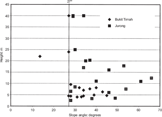
Data for 35 slope failures taken from Pitts,2 Tan et al.1,9 Lo et al.10 Wei et al.11 and Li7 have been plotted as slope angle against slope height in Fig. 3. This does not show any clear relationship between slope angle and slope height. However, virtually all the failed slopes show slope angles greater than or equal to 27°. Only one slope (Hillview Estate) failed at a lower slope angle (13·5°). It should be noted that this is an ‘average’ slope angle reported by Tan et al.1 It is possible that failure could have been initiated within a steeper part of the slope.
4. THE EFFECT OF RAINFALL
It is clear that rainfall has been the dominant triggering event for landslides in Singapore. The major slips have occurred during periods of very heavy rainfall (>100 mm/day). Similarly, the studies of minor landslides on the NTU campus show spates of landslides occurring after unusually wet periods.
There has been some discussion as to the role of antecedent rainfall (i.e. the rainfall in the days leading up to the event) as opposed to the daily rainfall at the time the event occurred. Brand19 suggested that antecedent rainfall was not a significant factor for landslides in Hong Kong. However, for the less permeable soils of Singapore it does have a major effect.1,7,12
Lumb13 used a 15-day period to quantify antecedent rainfall for Hong Kong. However, Chatterjea6 and Li7 have suggested that such a long period is inappropriate for the rainfall pattern in Singapore. They adopted periods of five and six days respectively. Data from Chatterjea,6 Wei et al.11 Li7 and Yang and Tang15 are plotted in Fig. 4 to show the effect of five-day antecedent rainfall. Data from Tan et al.1 Pitts,2 Li7 and Yang and Tang5 have been plotted in Fig. 5 for 15-day antecedent rainfall. Unfortunately, it has not been possible to plot all events on both plots as the cases have generally been reported using either one or the other period.
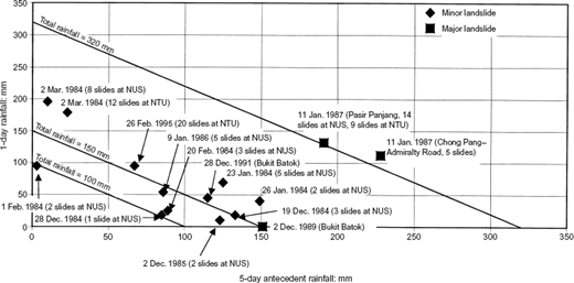
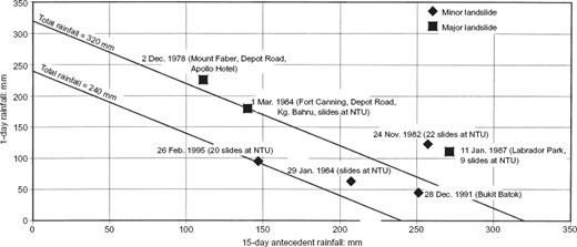
Figure 4 shows that some minor landslides have occurred after heavy one-day rainfalls with little antecedent rainfall (e.g. slides at NUS and NTU in February to March 1984). However, it can also be seen that other minor slides take place with low daily rainfall but where the five-day antecedent rainfall is significant (e.g. 28 December 1984). This suggests that the conditions for failure are dictated by total rainfall, since either daily or antecedent rainfall can induce failures. The diagonal line drawn in Fig. 4, representing a total rainfall of 100 mm in a six-day period, appears to define the minimum rainfall that has led to minor failures.
An equivalent lower bound line for minor failures in Fig. 5 shows a line defining a total rainfall in a 16-day period of 240 mm. However, it should be noted that there are very limited data for minor slides where 15-day antecedent rainfall data are available.
Lower bound lines have also been examined for major failures for both 5-day and 15-day antecedent rainfall periods. A line for total rainfall of 320 mm represents a lower bound for most of the cases in both Figs 4 and 5. However, the slide at Bukit Batok in December 1989 falls well below this line and is represented by a total rainfall line of 150 mm in six days. Unfortunately, there are insufficient data reported to determine the 15-day antecedent rainfall for this case study, although the monthly rainfall prior to the slide was reported as 316 mm. It is possible that this 316 mm fell in the 15 days prior to the landslide event but this cannot be substantiated.
Therefore, the data suggest that a total rainfall of 100 mm within a six-day period (equivalent to a sustained 15–20 mm/day for six days) is sufficient for minor landslides to take place. The condition for major landslides is less conclusive but perhaps 320 mm within 16 days could be taken as a possible indicator (equivalent to a sustained 20 mm/day for 16 days).
5. CONCLUSIONS
Major landslides in Singapore are an uncommon event. A small number of landslides greater than 10 m in height (up to 40 m) have occurred but less than 20 such events have been reported. Nevertheless, minor landslides occur frequently. A study of the major slope failures shows that only one major failure has occurred on a slope with an angle less than 27°. The data for minor slides on the NTU campus shows that only one of the 108 recorded slips was on a slope with an angle less than 27°. Therefore, it would seem that slopes formed in the Bukit Timah and Jurong formations at angles below 27° would have a low likelihood of failure.
It is clear that rainfall has been the dominant triggering event for landslides in Singapore. The periods when a significant number of major slips occurred were periods of very heavy rainfall (>110 mm/day). Similarly, the studies of minor landslides on the NTU campus show spates of landslides occurring after unusually wet periods. Observations of past landslides suggest that a total rainfall of 100 mm within a six-day period (equivalent to a sustained 15–20 mm/day for six days) is sufficient for minor landslides to take place. The condition for major landslides is less conclusive–perhaps 320 mm within 16 days could be taken as a possible indicator (equivalent to a sustained 20 mm/day for 16 days).
6. ACKNOWLEDGEMENTS
The author would like to thank Associate Professor Harianto Rahardjo and Associate Professor Leong Eng Choon for their help in compiling some of the information contained in this paper.

