Having recently written a paper entitled ‘Relationship between earthquake disturbance, tropical rainstorms and debris movement: an overview from Taiwan' (Chen & Hawkins, 2009), the discussers read the paper by Ching et al. (2011) with considerable interest. It describes an analysis of Route T-18 in Taiwan to demonstrate the suitability of a Guassian method to predict potential landslide locations and the amount of rain required to initiate such movements.
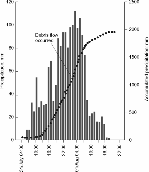
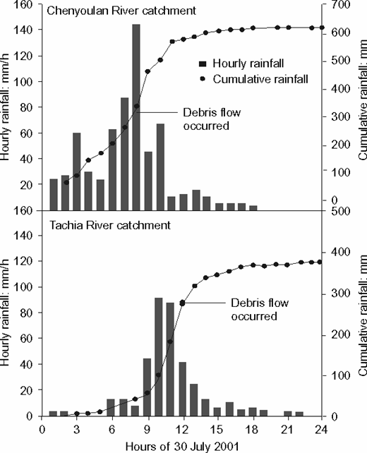
In their Fig. 1, the authors give the rainfall associated with four typhoons, based on that recorded during the week in which each took place. In the discussers' experience, in Taiwan the heavy typhoon rainfall occurs over a much shorter period. In their paper, the discussers provide the hourly rainfall at Hoser during Typhoon Herb and note that some 2 m of rain fell in 33 h, during which time more than 80 mm fell each hour between 1800 h on 31 July and 0600 h on 1 August 1996 (Fig. 9). They also provide the rainfall for the Chenyoulan catchment, noting that 480 mm fell in a 10 h period during Typhoon Toraji with a maximum of 147 mm in 1 h (Fig. 10). During the intense rainstorm of Mindulle, 166·5 mm of rain was recorded in 1 h on 2 July 2004. Such high hourly values suggest that a histogram such as that as presented by Ching et al. (2011) does not give a meaningful representation of the actual intensity of the rainfall. Indeed, even the 72 h period mentioned in the original paper obscures the dramatic impact of the typhoon storms.
With regard to slope failures related to typhoons, Chen & Hawkins (2009) note the significance of the topography on the distribution of the rainfall and the importance of circular air flows up to 170–200 km/h, such that during typhoons, there is no distinct ‘rain shadow'. Further, as a consequence of the circular motion, sudden changes in wind direction occur, causing much swaying of the trees, and hence stress/disturbance of the near-surface materials.
In view of the seismic setting of Taiwan, it is surprising that no mention is made of the paper by Yin (2008), which compares the number of rock collapses, landslides, debris flows and unstable slopes in the Sichuan Province of China before and after the Wenchuan earthquake of 12 May 2008. The discussers carried out a similar study for Taiwan and reported the heavy rainfall events between 1996 and 2004; before and after the Ml 7·3 Chi Chi earthquake on 21 September 1999 (see Table 7 adapted from Chen & Hawkins, 2009). This emphasises that, although the accumulated rainfall of Typhoon Herb (pre-Chi Chi) was some 2·5 times greater than that associated with Typhoon Toraji, because of the earthquake disturbance the effects of the latter were much greater: that is, there were more than 300 debris flows following Typhoon Toraji compared with only 73 recorded at the time of Typhoon Herb.
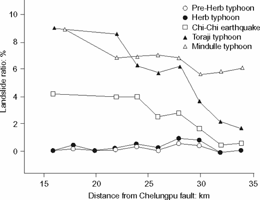
The effect of the earthquake disturbance is also seen when assessing the number of landslides and their distance from the Chelungpu fault, which was reactivated at the time of the Chi Chi earthquake. As seen in Fig. 11, the distance from the fault does not appear to have had any influence on the number of landslides recorded before and at the time of Typhoon Herb, but is clearly reflected in the number of landslides which occurred at the time of Typhoon Toraji.
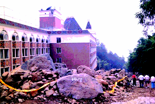
Figure 9 shows the hourly rainfall during the passage of Typhoon Herb (pre-Chi Chi) and indicates that the debris flows occurred when the accumulated precipitation reached 1100 mm (Chen, 2006). When Typhoon Toraji passed over the island two years after Chi Chi, debris flows in the Chenyoulan catchment commenced after some 300 mm of accumulated rainfall and in the Tachia catchment after 280 mm (Fig. 10). Clearly, the authors are unable to speculate on the effect of the next seismic event; however, any slope movement will be significantly influenced by this. It is of note that during the limited rainfall at the time of Typhoon Toraji, boulders up to 40 t in weight were moved in the area of the Mi Ti hotel (Fig. 12), largely as a result of the prior disturbance of the near-surface geology during the Chi Chi earthquake.
Figure 2 from the original paper implies that along the T-18 there were a considerable number of failures associated with Typhoon Herb. The authors do not point out that the T-18 was not completed until the 1980s and hence it is possible that Typhoon Herb was the first really significant period of rainfall following the construction works.
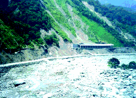
It is also possible that what the authors have recorded as ‘upslope failures' were the consequence of ‘road base wash-away': that is, they occurred following the undercutting of the slope when large clasts were transported down-river during the intense rainstorms. Fig. 13 shows part of the Cross Island Road where a rock shelter was abandoned when the base of the hill was undercut at the time of Typhoon Toraji; beneath the former road, a temporary road is shown, constructed along the edge of the river. Such failures result in a loss of support of the highway and upper slopes.
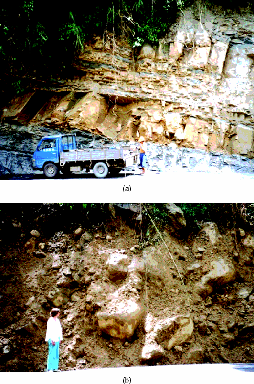
It is also surprising that the authors classified the strata in terms of their geological age (from young to old). If their hypothesis is related to the effect of rainfall, would it not be more appropriate to consider the influence of the different lithologies, their orientation and declination with respect to the free face, the presence of bedding plane shears created during folding/earthquake motion and the permeability of the strata? Although the authors comment on the lithologies being mainly sandstone and shale, they do not emphasise the presence of joints, which control the high permeability in the sandstones, or the low permeability of the mudrock/shale bands. In their paper the discussers produce photographs of two road cuttings which show both in situ strata and material which has suffered mass movement (Figs 14(a) and (b)). In their discussion of the T-18, were the authors discussing material which was in situ or in its disturbed/temporarily stable state? In view of the huge size of some of the moved blocks observed, the manner in which further movement may be initiated and the catastrophic effect of such blocks falling onto a highway need assessment in any prediction analysis and should be taken into account in any modelling.
It is not only the accumulated rainfall but also the rate of water ingress into the soil, the temporary load imposed and the rate of egress which are important factors when assessing slope stability in Taiwan. Although Fig. 4 shows some of the topographic effects, no differentiation is made between the effect of the rain falling along the T-18 and that falling on the higher slopes, which will penetrate into the strata and egress as springs where the slope decreases and/or the vegetation cover has been reduced – notably instances where road cuttings have been made.
There is no discussion of the fact that in such areas as Taiwan there is a considerable downslope creep, such that in the densely forested terrain the progressive movement of the near-surface material will frequently not show up on aerial photographs, which have a resolution of 40 × 40 m. As a consequence, it is extremely difficult to be confident in locating areas of ‘non-failed' slopes. Even with field visits, unless an on-going survey is undertaken, the creep movement is hard to elucidate, hence it is difficult to categorise ‘non-failed' slopes.
In summary, while the authors offer an interesting approach to landslide prediction along the T-18, the discussers are concerned that the factors and weightings used are not the most appropriate and are likely to give rise to misleading results. This is supported by the fact that reducing their ten factors to five actually improved the error ratio. As the authors themselves note when discussing prediction errors ‘…there are some missing essential features'.
We hope the above will assist the authors in reconsidering their approach.
Authors' reply
The discussers provide an in-depth view on the debris flow problems that occurred in typhoon season in Taiwan. These comments are greatly appreciated and the authors would like to use this chance to clarify several conditions and limitations of their work. The replies will focus on four subjects: (a) choice of rainfall index; (b) effect of Chi-Chi earthquake; (c) non-failure cases; and (d) selection of features.
CHOICE OF RAINFALL INDEX
The discussers seem mainly to be concerned about landslides or debris flows that were triggered during or soon after the heavy rainfall that accompanies typhoons. In the case of debris flows, they argued that the short-term rainfall intensity is essential. They also provided the short-term rainfall intensity data for a case history as evidence (Fig. 9), in that a debris flow is shown to occur soon after the rise of rainfall intensity.
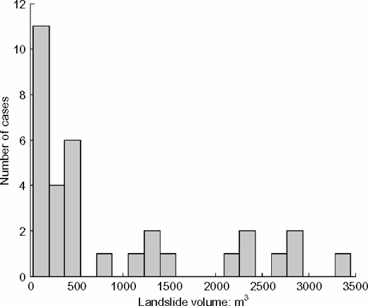
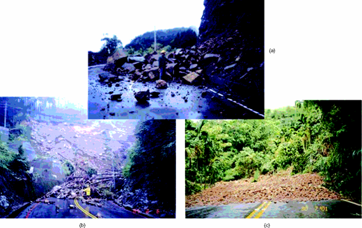
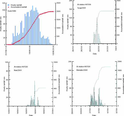
The authors appreciate that the discussers provided such an observation from other mountain areas and also agree that short-term rainfall intensity plays an important role for debris flows. However, the mechanisms of roadside landslide of Route T-18 mountain road may not be solely governed by short-term rainfall intensity, because even under the extreme rainfall conditions of typhoon, many roadside slopes still remained stable, although other slopes failed. For the authors' case, the landslides along Route T-18 are mostly shallow landslides which involve a limited amount of slope mass movement. Fig. 15 shows the histogram of the landslide volumes of 33 landslides that occurred along Route T-18. All of them are small-scale failures ranging from less than 100 m3 to 3500 m3, with the majority less than 500 m3. Fig. 16 shows the common landslide types observed along Route T-18. Among them, the shallow slip and sliding + flowing types, which involve the rainfall infiltration into the slope, account for most slope failure. The infiltration process not only reduces the effective stress in the slope by eliminating matric suctions inside the unsaturated slope material but also increases the unit weight of the downwards moving slope. Such a continuous and infiltration process to a significant depth requires some duration of rainfall and depends on the permeability of cover material. For the failed slope cases, the time of landslide was unknown owing to the road being shut down under extreme weather conditions. It was decided to use the largest duration time of the selected typhoons, that is 72 h (Mindulle, Fig. 17), as the time slot for the calculation of average rainfall.
The rainfall index chosen in the paper (referred to as ‘effective rainfall amount') was the combination of a 72 h average rainfall and a maximum 12 h moving average rainfall. This index was chosen to match the observed failure and non-failure cases. In fact, the maximum 12 h moving average represents the effect of short-term rainfall intensity on slope. Using this index, the authors found that indices solely based on short-term rainfall intensity did not provide a better match. In a recent report for the large-scale dip slope failure that occurred at National Freeway No. 3 in Taiwan (Taiwan Geotechnical Society, 2011), a 7-day moving accumulative rainfall was used to obtain an optimal correlation between rainfall index and observed ground water level rise.
Rahardjo et al. (2005) found that rainfall over a residual soil slope in Singapore in excess of 10 mm usually generates runoff. The authors agree that high hourly rainfall with great intensity may cause the sliding slope material to become a flow type material during its downwards movement (debris flow). It may not be as meaningful to the T-18 cases involving shallow slip failures. In fact, for the extremely high intensity hourly rainfall, most of the water may run off and erode the slope surface and may result in a sliding + flowing type failure (Fig. 16). Even in such a case, the debris volume involved is still no match for that of debris flow commonly observed on the river-side slopes in Taiwan.
DISTURBANCE EFFECT OF CHI-CHI EARTHQUAKE
The discussers provided a few excellent examples highlighting the disturbance effect of Chi-Chi earthquake (in 1999). They also mentioned the findings of Yin (2008). The intention was to highlight the fact that the disturbance effect from the Chi-Chi earthquake cannot be ignored. The authors believe this evidence is valid and also agree with the discussers. This point was not highlighted in the original paper, and the authors would like to take this chance to clarify it.
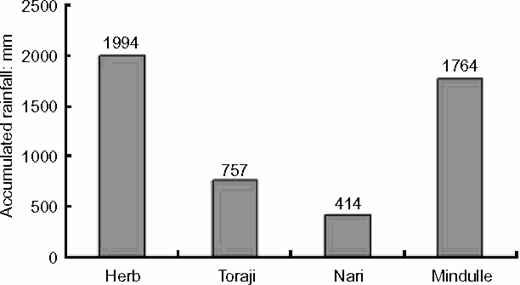
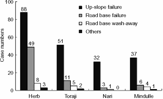
The effect of the Chi-Chi earthquake can be seen from Figs 18 and 19, the same as Figs 1 and 2 in the original paper. Typhoon Herb (in 1996) was before the Chi-Chi earthquake and the other three typhoons (Toraji and Nari in 2001, Mindulle in 2004) are after. Typhoon Herb caused a large number of landslides, but the remaining slopes that did not fail during Herb are likely to be stronger slopes. If the point given by the discussers also applies to the slopes along Route T-18, these remaining slopes might later be disturbed and hence weakened by the Chi-Chi earthquake. This may explain why during Toraji and Nari (post Chi-Chi) there were still a significant number of failures, although the rainfall was far less than Herb (Table 8).
However, Figs 18 and 19 reveal that the rainfall amount of Typhoon Mindulle is much higher than Toraji and Nari, but landslides that occurred during Mindulle were not more than those during Toraji and Nari. In addition, the reccurrence of landslide at the same road section is quite common in Route T-18. This observation may be attributable to the same aforementioned reason – slopes that did not fail during Toraji and Nari are stronger and those that failed had been strengthened, so many of them did not tend to fail during Mindulle. That is to say, if the disturbance effect of Chi-Chi earthquake is real, this effect may have faded out after Toraji and Nari. At the time of Mindulle, this effect no longer seemed to play an important role. This fade-out phenomenon for the Chi-Chi effect was also confirmed by Wu (2002) after he analysed pre- and post-Chi-Chi slope cases along Route T-18. Note that although this fade-out for the Chi-Chi effect may exist for the slopes along Route T-18, it may not be as obvious for debris flows mentioned by the discussers. Although there are numerous potential debris flows spreading over large areas in mountains, not many were spotted along Route T-18.
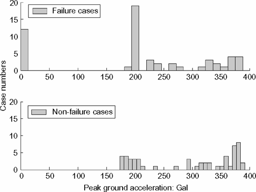
The fade-out of the Chi-Chi disturbance effect implies that such an effect is transient in time. Note that the analysis made in the original paper is based on a time-invariant model, and the data cover a long time span. The analysis may not be able to identify such a transient effect. In Tables 2 and 3 of the origial paper, the Chi-Chi effect was quantified by the interpolated peak ground accelerations (PGAs) at the slope sites during the Chi-Chi earthquake. For slopes failed before the earthquake, these PGAs are taken to be zero because they did not experience the Chi-Chi earthquake before the failures. Fig. 20 shows the histograms of the PGAs for failure and non-failure cases. It is evident that PGAs for failure and non-failure cases are similar if the Chi-Chi disturbance effect is indeed transient in time. This also explains why in Table 5 of the original paper, the conclusion was that PGA is not an important parameter.
The fade-out of the Chi-Chi disturbance effect also implies that for the purpose of predicting future cases, such an effect can be ignored. Hence, excluding the PGA parameter in the analysis should not greatly influence the predictions for future cases.
NON-FAILURE CASES
The discussers mentioned that some cases classified as non-failure may be actually failure cases from the viewpoint of downslope creep. Downslope creep is a very common phenomenon in the mountainous regions in Taiwan, and most mountain roads are affected by such creep. This creep can be identified when long cracks show up on road pavement.
The purpose of this study, however, is mostly engineering rather than geologic. Downslope creep may be considered as failure from a geologic viewpoint, but it is typically not considered as failure for engineering purposes, as most roads are still operational under this creep condition. In fact, this study classifies a slope to ‘failure' only when the failure interrupted traffic.
SELECTION OF FEATURES
A major challenge for this study is to develop a predictive model based on a collection of failure and non-failure cases as calibration data. Only features that are known and readily available for all cases can be incorporated into the calibration analysis. Features such as temporary imposed load and egress rate are difficult to obtain and hence were not included. The authors admitted this omission, so stated that ‘there may be some missing essential features' in the original paper.
From the perspective of real application, it is not necessarily a drawback only to incorporate features that can be easily obtained. The benefit is that the use of the resulting predictive model only requires those simple features. In contrast, if difficult features are incorporated, the resulting predictive model may have better predictive capacity, but the model might become unpractical for real application.
When a mountain road is selected as the subject of a road-side slope stability problem, the subject is well defined and the inherent constraints of the road are applied in the study as well, such as the geological, geographical, topographical and rainfall conditions. In other words, each mountain road has its own characteristics which are different from others. Therefore, the features chosen for the calibration analysis on stability of road-side slopes should be closely related to the characteristics of the road. Owing to the large number of road-side slopes involved, it is practically impossible to obtain all the necessary parameters needed for the stability analysis of each slope. Instead, the selected features need to be readily available locally or remotely and also must be crucial to the stability of slopes. In general, most of the road-side slopes are subjected to various extents of construction activities and some slopes are stabilised by man-made structures. They are not expected to behave in a similar way to the natural slopes or terrains located along river-sides where a large number of typhoon-induced debris flows are likely to occur, as shown in Fig. 13. In addition, the debris volume associated with landslide along Route T-18 is on a small scale (Fig. 15). Such a volume is considerably smaller than the volume of debris flow commonly found on the slope of a river-side mountain road in Chenyoulan River catchment where the discussers observed the debris flow. In fact, the scale and failure mechanism of the road-side landslide are quite different from the river-side landslide/debris flow. Such differences can explain most of the different points held by the authors and the discussers.