Ground subsidence – the gradual or sudden lowering of the Earth’s surface – poses serious threats to infrastructure, environmental safety, and sustainable land use. Accurate prediction is therefore crucial for effective risk management. This review provides a comprehensive synthesis of subsidence prediction methods developed over the past two decades, spanning traditional empirical, analytical, and numerical approaches, as well as recent advances in deep learning. This review summarises the theoretical foundations and practical performance of major model classes, with emphasis on their ability to capture complex spatiotemporal patterns. Comparative analysis highlights the superior flexibility and accuracy of deep learning methods, while underscoring their challenges in data dependency and interpretability. Future research directions are discussed, focusing on physics-informed learning, multi-source data fusion, and uncertainty quantification. Integrating physical understanding with data-driven intelligence represents a promising pathway towards more accurate, interpretable, and robust subsidence prediction frameworks.
Introduction
Ground subsidence, characterised by the downward displacement of the Earth’s surface, represents one of the most pervasive and destructive geohazards worldwide. It arises from a complex interplay of natural processes and anthropogenic activities (Galloway and Melillo, 1998; Poland, 1984). Natural mechanisms include tectonic movements, the dissolution of soluble rocks, natural sediment compaction, and volcanic activity, each contributing to varying spatial and temporal subsidence scales. However, over the past century, intensive human exploitation of subsurface resources has dramatically amplified the rate and extent of subsidence in many regions. Key anthropogenic drivers include excessive groundwater extraction, underground and open-pit mining, hydrocarbon withdrawal, dissolution mining, and the drainage of organic-rich soils (Gambolati et al., 2000, 2005; Hu et al., 2004). These activities disturb the geomechanical equilibrium of subsurface formations, leading to ground deformation that may evolve gradually or abruptly depending on the geological setting and hydromechanical properties of the strata.
The consequences of ground subsidence are often severe and multi-faceted. They include structural damage to buildings, roads, railways, pipelines, and other critical infrastructure; deformation of drainage systems; increased flood risk in coastal and low-lying regions; reactivation of geological faults; and degradation of natural ecosystems (Carbognin et al., 2010; Phien-wej et al., 2006). The socioeconomic losses associated with these impacts can be immense, particularly in rapidly urbanising or industrialising regions. For instance, major cities such as Mexico City, Jakarta, and Beijing have experienced cumulative subsidence exceeding several metres in the last few decades, threatening long-term urban sustainability. Consequently, understanding the mechanisms, monitoring the evolution, and accurately predicting the spatiotemporal development of ground subsidence are critical for effective risk mitigation, land-use planning, and sustainable resource management.
Over the past several decades, researchers have developed a wide range of approaches to predict ground subsidence. Early methodologies were predominantly empirical, relying on statistical relationships derived from field observations and historical records. These models, while simple and practical, were often site-specific and limited in their ability to generalise beyond the conditions under which they were calibrated (Whittaker et al., 1991). Analytical models subsequently emerged, employing closed-form mathematical expressions based on principles of elasticity, plasticity, and poroelasticity to describe subsurface deformation caused by loading or fluid withdrawal (Geertsma, 1973). With increasing computational capabilities, numerical methods – particularly the finite element method (FEM) and finite difference method (FDM) – became dominant tools for simulating the coupled hydro-mechanical processes underlying subsidence (Kratzsch, 1986; Peng et al., 2019). These methods enable the representation of heterogeneous geological structures and complex boundary conditions, providing detailed insights into deformation mechanisms. However, they are constrained by uncertainties in subsurface parameters, simplifications of constitutive models, high computational demands, and limited scalability for large-area or long-term simulations (Aston et al., 1987; Bahuguna et al., 1991; Cai et al., 2023).
In parallel with the evolution of computational methods, advances in geospatial monitoring technologies – such as Interferometric Synthetic Aperture Radar (InSAR), global positioning system (GPS), and levelling surveys – have revolutionised subsidence observation (Chaussard et al., 2014; Osmanoğlu et al., 2011). These high-resolution datasets have made it possible to continuously monitor ground deformation over wide regions with unprecedented temporal and spatial precision. The availability of such large-scale datasets has naturally prompted a paradigm shift towards data-driven approaches, particularly those leveraging machine learning (ML) and deep learning (DL) techniques.
In recent years, artificial intelligence (AI) has profoundly influenced the field of geoscience modelling. DL models, including convolutional neural networks (CNNs) (LeCun et al., 1998), recurrent neural networks (RNNs) (Mikolov et al., 2010), long short-term memory (LSTM) networks (Hochreiter and Schmidhuber, 1997), and more recently Transformer architectures (Vaswani et al., 2017), have shown remarkable capability in learning non-linear mappings and complex dependencies directly from data, bypassing the need for explicit physical formulations (LeCun et al., 2015). These models can process large, heterogeneous datasets and extract spatial, temporal, or spatiotemporal features essential for subsidence prediction (Gao et al., 2019; Soni et al., 2025). For example, CNNs are particularly effective in capturing spatial deformation patterns from InSAR imagery, while RNNs and LSTMs excel at modelling the temporal evolution of surface displacement. Hybrid architectures such as CNN-LSTM or attention-based models combine these strengths to achieve superior predictive accuracy (Chen et al., 2024; Seo and Lee, 2021).
Moreover, emerging research has begun to explore the connection between DL architectures and neurodynamic systems. For instance, Ramsauer et al. (2020) established a theoretical equivalence between Hopfield neural networks (HNNs) and Transformer attention mechanisms, highlighting a conceptual bridge between associative memory networks and modern DL. This connection has reinvigorated interest in explainable neural architectures, such as HNNs and energy-based models, which may offer interpretable insights into the internal reasoning processes of data-driven prediction systems (Bao and Zhao, 2024; Burns and Fukai, 2023; Lucibello and Mézard, 2024). Such developments point towards a new generation of predictive frameworks that combine the interpretability of physics-based models with the adaptability of data-driven learning.
Against this backdrop, this review aims to provide a comprehensive and up-to-date synthesis of ground subsidence prediction methodologies, encompassing both traditional physics-based approaches and the emerging family of DL techniques. We first present a systematic overview of empirical, analytical, and numerical methods, outlining their theoretical foundations, computational implementations, and typical application scenarios. Next, we examine the evolution of data-driven subsidence prediction, with a particular focus on DL architectures, training strategies, and performance evaluations in real-world case studies. A comparative analysis between traditional and DL approaches is conducted in terms of predictive accuracy, data dependency, computational efficiency, scalability, and interpretability. Finally, the review identifies major research gaps and future directions, emphasising opportunities in physics-informed ML, multi-source data fusion, model interpretability, and uncertainty quantification.
By integrating insights from both geomechanical theory and AI, this review seeks to guide future research towards the development of robust, interpretable, and generalisable models for ground subsidence prediction-contributing to safer infrastructure design, more effective resource management, and sustainable urban development worldwide.
Traditional methods
Traditional methods for ground subsidence prediction have evolved over several decades, forming the foundation of subsidence analysis and forecasting. These methods can be broadly categorised into empirical, analytical, and numerical approaches, each with distinct characteristics, advantages, and limitations. This section provides a comprehensive review of these traditional approaches, their underlying principles, representative techniques, and applications in ground subsidence prediction.
Empirical methods
Empirical methods are primarily based on statistical relationships derived from historical monitoring data and field observations. These methods typically employ mathematical functions calibrated using measured subsidence data to predict future deformation patterns.
Probability integral method
The probability integral method, originating in the mid-20th century (Peck, 1969), has been widely applied in mining-induced subsidence prediction, particularly in China, Poland, and Germany (Kratzsch, 1986; Whittaker et al., 1991). This method assumes that the influence of underground excavation on surface points follows a normal probability distribution.
The basic form of the probability integral function can be expressed as:
where represents the subsidence at point , is the maximum subsidence, and r is the radius of influence. This type of approach was previously employed by Peck (1969) to characterise tunnelling-induced settlements in soft ground.
The probability integral method has been continuously refined over time. Yang and Xia (2013) proposed a model for predicting surface movement and deformation induced by subcritical mining, incorporating additional parameters to account for geological conditions. More recently, Chi et al. (2021) developed an MIV-GP-BP model for calculating probability integral method parameters, enhancing prediction accuracy.
Despite its widespread application, the probability integral method faces several limitations. The determination of key parameters often relies heavily on empirical knowledge, and the method shows reduced accuracy in complex geological conditions with significant heterogeneity or discontinuities (Cai et al., 2023).
Influence function method
The influence function method, closely related to the probability integral method, describes how a unit extraction at a point in the subsurface influences surface subsidence. The total subsidence at any surface point is calculated by integrating the influences from all extraction points within its influence range.
The Knothe influence function, proposed by Knothe (1957),
where is the influence function, r is the horizontal distance from the extraction point to the calculation point, and is the radius of the principal influence.
Numerous modifications to the basic influence function have been proposed to account for various factors. Zhou et al. (2022) developed an improved influence function method considering topographic effects, which significantly enhanced prediction accuracy in mountainous areas. Cai et al. (2023) provided a comprehensive review of influence function methods and their applications in different geological settings.
The influence function method offers advantages in computational efficiency and ease of implementation. However, it shares similar limitations with the probability integral method, including challenges in parameter determination and reduced accuracy in complex geological environments (Han et al., 2023).
Other empirical methods
Besides the probability integral and influence function methods, various other empirical approaches have been developed for specific subsidence scenarios. Table 1 summarises these methods, their key contributions, and representative studies from the literature. These approaches range from statistical analysis and regression techniques to time series methods, each offering distinct advantages depending on data availability and prediction requirements.
Empirical methods generally offer advantages in simplicity, computational efficiency, and minimal data requirements compared to more complex approaches. However, their accuracy is heavily dependent on the quality and representativeness of historical data, and they often struggle to account for changes in subsidence mechanisms or environmental conditions (Gambolati et al., 2005).
Analytical methods
Analytical methods are based on mathematical solutions derived from physical principles, typically employing simplified assumptions to make the equations solvable. These methods provide insights into the underlying mechanics of subsidence processes.
Elastic models
Elastic models, rooted in the theory of elasticity, describe ground deformation under the assumption that the subsurface materials behave elastically. These models have evolved from simple homogeneous half-space solutions to more complex formulations accounting for material layering and anisotropy.
A fundamental elastic model for subsidence prediction was developed by Geertsma (1973), who derived an analytical solution for surface subsidence due to reservoir compaction:
where is the vertical displacement, is Poisson’s ratio, is the uniaxial compaction coefficient, is the pressure change, R is the reservoir radius, h is the reservoir depth, is the radial distance, and and are Bessel functions.
Aston et al. (1987) presented a comprehensive review of elastic models for mining-induced subsidence, highlighting their evolution and applications in different geological settings. Then Chang et al. (2015) proposed a new model for predicting surface subsidence under thick alluvium conditions, incorporating elastic theory with empirical corrections. Recently, Sepehri et al. (2017) applied an elastoplastic finite element model to predict mining-induced surface subsidence and ground movements at a Canadian diamond mine, offering a scientific basis for assessing and mitigating geological impacts in mining operations.
While elastic models provide valuable theoretical foundations, they often oversimplify the complex behaviour of geological materials, which typically exhibit non-linear, time-dependent, and irreversible deformation characteristics.
Poroelastic models
Poroelastic models extend elastic theory by incorporating the coupling between fluid flow and solid deformation in porous media. These models are particularly relevant for subsidence caused by fluid extraction or injection.
The fundamental theory of poroelasticity, developed by Biot (1941), describes the relationship between pore pressure changes and solid matrix deformation. Building on this foundation, Helm et al. (2010) developed analytical solutions for subsidence due to groundwater withdrawal, accounting for both instantaneous elastic and time-dependent inelastic compaction.
Recent advancements in poroelastic modelling include the work of (Ye et al., 2016), who proposed a three-dimensional poroelastic model for land subsidence prediction in Shanghai. This study conducted three-dimensional numerical modelling of land subsidence in Shanghai, China, providing a detailed analysis of subsidence mechanisms and contributing to the development of effective strategies for subsidence mitigation and urban planning.
Poroelastic models provide a more realistic representation of subsidence mechanisms compared to simple elastic models. However, they require detailed knowledge of hydrogeological and geomechanical parameters, which can be challenging to obtain in practice (Galloway and Leake, 2016).
Numerical methods
Numerical methods employ discretisation techniques to solve complex mathematical equations that cannot be solved analytically. These methods can accommodate realistic geometries, heterogeneous material properties, and non-linear behaviour, making them powerful tools for subsidence prediction in complex geological settings.
Finite element method
The FEM divides the domain of interest into smaller elements, approximating the solution within each element using interpolation functions. FEM has been extensively applied in subsidence modelling due to its flexibility in handling complex geometries and material behaviours.
Hoek (2001) applied FEM to simulate rock mass deformation and failure mechanisms in mining environments, providing insights into subsidence development. Kaitantzian et al. (2015) used FEM to assess complex mechanical behaviours in areas with multiple interacting subsidence mechanisms.
Advanced FEM applications include coupled hydro-mechanical models that simultaneously solve for fluid flow and solid deformation. Ye et al. (2016) developed a coupled FEM model for Shanghai, incorporating time-dependent consolidation processes and spatial variations in material properties.
While FEM offers significant advantages in modelling complex subsidence scenarios, it requires careful mesh design, appropriate boundary conditions, and substantial computational resources, especially for large-scale or long-term simulations (Galloway and Leake, 2016).
Finite difference method
The FDM approximates derivatives in governing equations using difference quotients on a grid. FDM is particularly suitable for problems with regular geometries and has been widely used in subsidence modelling due to its relative simplicity and computational efficiency.
Helm et al. (2010) employed FDM to simulate aquifer-system compaction and land subsidence, developing the widely used MODFLOW subsidence package. This approach has been continuously refined, with recent applications including the work of Zhu et al. (2013), who used FDM to simulate land subsidence in Beijing. After that, Zhu et al. (2015) investigated the extent and mechanisms of land subsidence caused by groundwater withdrawal in the northern Beijing Plain, China, providing critical data and analysis to support the development of sustainable water resource management strategies and mitigate the associated geological hazards in the region. In addition, Chen et al. (2023) provided a comprehensive numerical simulation framework to investigate the mechanisms and patterns of land subsidence induced by groundwater extraction, offering valuable insights into the relationship between groundwater withdrawal and surface deformation, and contributing to the development of sustainable groundwater management strategies.
FDM offers advantages in implementation simplicity and computational efficiency for certain problems. However, it faces challenges in representing complex geometries and material interfaces, which can limit its applicability in heterogeneous geological settings (Galloway and Leake, 2016).
Discrete element method
The discrete element method (DEM) models materials as assemblies of discrete particles interacting through contact forces. DEM is particularly suitable for simulating discontinuous phenomena such as fracturing, block movement, and large deformations.
Dai et al. (2003) used DEM to study surface discontinuous deformations induced by steeply inclined coal seam mining. Xu et al. (2016) applied DEM to simulate strata movement in fully mechanised coal mining, capturing discontinuous deformation patterns that are challenging to model with continuum-based methods.
While DEM excels at capturing discontinuous phenomena, it requires extensive parameter calibration and significant computational resources, especially for large-scale problems with millions of particles (Peng et al., 2019).
Comparative analysis of traditional methods
Traditional methods for predicting ground subsidence exhibit distinct advantages and limitations, reflecting their underlying theoretical assumptions, data requirements, and computational frameworks. Among these, empirical, analytical, and numerical methods represent three major paradigms that have evolved in parallel with advancements in field observation, geotechnical understanding, and computational technology. Each category occupies a specific niche in practical applications, depending on the complexity of geological conditions, data availability, and desired prediction accuracy.
Empirical methods, which rely on statistical correlations and empirical formulas derived from historical monitoring data, are typically the most straightforward to implement and computationally efficient. Their simplicity makes them particularly useful for rapid assessments in regions where extensive observation records exist and subsidence patterns remain relatively stable over time. However, these methods are inherently site-specific and limited in their ability to extrapolate beyond the calibration conditions. Their accuracy tends to deteriorate in heterogeneous or evolving geological settings, where the empirical relationships fail to capture the underlying physical mechanisms governing deformation (Cai et al., 2023).
Analytical methods bridge the gap between empirical and fully numerical approaches by representing subsidence behaviour through closed-form mathematical expressions derived from elasticity, viscoelasticity, or poroelasticity theories (Geertsma, 1973). These methods can provide deeper physical insights into deformation mechanisms and allow for parametric sensitivity analyses under controlled assumptions. Analytical approaches are particularly effective in simplified geological contexts, such as uniform strata or axisymmetric reservoirs, where boundary conditions and constitutive relations can be expressed explicitly. Nevertheless, their reliance on idealised assumptions – such as isotropy, homogeneity, or linear material behaviour – limits their applicability in complex real-world scenarios. Deviations between theoretical assumptions and actual geological conditions can lead to substantial predictive errors, especially in areas with pronounced heterogeneity or non-linear hydro-mechanical coupling (Gambolati et al., 2000).
Numerical methods, including FEM and FDM, constitute the most physically rigorous category of traditional approaches. By discretising the subsurface into computational grids or elements, these models solve the governing equations of stress, strain, and fluid flow numerically (Peng et al., 2019). In principle, they can accommodate complex geological geometries, heterogeneous material properties, and coupled processes such as consolidation, fault reactivation, and pore-pressure dissipation. While numerical simulations can offer high predictive capability, their accuracy relative to other methods depends critically on the scale and context of the problem. For instance, in the case of small-scale settlements induced by tunnelling in soils, empirical methods often provide the best match with observed deformation profiles, with numerical methods achieving comparable accuracy only when advanced constitutive models are employed and the initiating phenomena are represented with sufficient precision; at smaller scales, the strain-dependence of ground stiffness exerts a significant influence on the spatial distribution of the settlement trough, a complexity that must be adequately captured in any numerical simulation. These considerations notwithstanding, numerical modelling generally entails substantially greater computational expense and data requirements than empirical or analytical alternatives. Constructing a reliable numerical model demands detailed geological, hydrogeological, and geomechanical information-parameters that are often difficult or expensive to obtain, particularly for deep or inaccessible formations (Galloway and Melillo, 1998). Furthermore, model calibration and validation can be labour-intensive, as even modest parameter uncertainties may propagate into considerable deviations in predicted displacements.
Despite their long-standing success, all traditional prediction methods share several fundamental challenges. First, parameter acquisition remains a major bottleneck: the physical parameters governing subsidence, such as compressibility, permeability, and elastic moduli, are rarely known with sufficient spatial resolution, leading to uncertainty in model outputs (Galloway and Melillo, 1998). Second, the simplifying assumptions embedded in both analytical and numerical formulations – ranging from linear elasticity to isotropy – often fail to represent the true complexity of subsurface systems, especially when multiple geological layers or processes interact (Cai et al., 2023). Third, the computational cost associated with high-resolution numerical models can become prohibitive for large-scale or long-term simulations, forcing researchers to trade off spatial detail for feasibility (Peng et al., 2019). Finally, many traditional frameworks struggle to capture non-linearities, hysteretic behaviour, and coupled multi-physics processes, such as the interplay between fluid extraction, stress redistribution, and time-dependent creep deformation (Gambolati et al., 2000).
These inherent limitations have driven a paradigm shift in recent years towards data-driven approaches, particularly those leveraging advances in ML and DL. Unlike physics-based models, data-driven methods learn functional relationships directly from monitoring data, enabling them to capture highly non-linear and spatio-temporal patterns without the need for explicit constitutive assumptions. As such, they offer a promising complementary pathway for improving the accuracy, adaptability, and scalability of ground subsidence prediction in complex and data-rich environments.
Tunnelling-induced settlement
Accurate prediction of tunnelling-induced ground movements represents a critical requirement for the safe development of underground infrastructure in densely populated urban environments. Research in this domain has evolved progressively from early experimental and analytical foundations towards increasingly sophisticated numerical, physical, and data-driven methodologies, reflecting a broader trend observed in geotechnical engineering towards integrating multi-source information and capturing complex coupled processes.
Early contributions established fundamental mechanistic insights that continue to inform contemporary practice. Grant and Taylor (2000) presented comprehensive centrifuge model test results examining tunnelling-induced ground movements in clay, offering critical experimental evidence on deformation mechanisms and settlement trough development in soft ground conditions. Complementing these experimental findings, Park (2005) derived a closed-form analytical solution based on elastic continuum theory, providing a mathematically rigorous framework for predicting surface settlements that has been widely adopted in engineering design. These foundational studies illustrate the complementary roles of physical modelling and theoretical derivation in establishing the core principles of ground movement prediction.
The interaction between tunnelling-induced deformations and existing surface structures constitutes a further layer of complexity that has received sustained attention. Potts and Addenbrooke (1997) established, through numerical modelling, the fundamental influence of building stiffness on ground movement patterns, demonstrating that surface structures substantially modify the greenfield settlement trough and that soil-structure interaction effects must be incorporated into design methodologies to avoid either overestimation or underestimation of potential structural damage. This principle was subsequently refined by Ritter et al. (2017), who employed centrifuge testing with three-dimensionally printed structural models to systematically investigate how specific building characteristics – including position relative to the tunnel alignment, length, and facade openings – alter surface and subsurface displacement fields. Their findings revealed that building distortions and horizontal strains are significantly affected by the relative positioning of structures, underscoring the need for case-specific assessments in urban tunnelling contexts.
Hydrogeological conditions represent another critical factor governing ground response, particularly in permeable strata where coupled hydro-mechanical processes dominate. Yoo et al. (2012) documented a case history of excessive settlements reaching 160 mm during New Austrian Tunnelling Method construction beneath an airport apron in Seoul, demonstrating that groundwater drawdown induced by tunnelling in water-bearing ground can generate consolidation settlements substantially exceeding those attributable to excavation alone. This case highlights the necessity of coupled hydro-mechanical analysis in groundwater-rich environments, where pore-pressure dissipation and effective stress changes can significantly influence both short- and long-term deformation behaviour. Similarly, Zhang et al. (2018) investigated tunnelling-induced geohazards in mylonitic rock faults with rich groundwater through a case study in Guangzhou, identifying the specific mechanisms of instability and water inrush risks associated with fault zones during mechanised tunnelling, thereby emphasising the importance of geological heterogeneity in hazard assessment.
The advent of advanced monitoring technologies has substantially enhanced the capacity for precise deformation assessment at regional and local scales. Karunathilake et al. (2024) demonstrated the application of Sentinel-1 Persistent Scatterer Interferometric Synthetic Aperture Radar (PS-InSAR) for assessing tunnel-induced land subsidence in densely populated residential areas, establishing that spaceborne synthetic aperture radar technology provides millimetre-accuracy measurements essential for large-scale infrastructure monitoring and early warning systems. Such remote sensing techniques offer particular advantages in urban environments where conventional ground-based instrumentation may be logistically constrained or insufficiently dense to capture spatial deformation patterns comprehensively.
Parallel to advances in monitoring, predictive methodologies have increasingly incorporated computational intelligence and data-driven approaches. Chang et al. (2023) developed a novel correlation analysis framework linking ground subsidence to tunnelling parameters through qualitative and quantitative model fusion, utilising MAX-MIN Ant System algorithms and improved Beetle Antennae Search-Deep Neural Networks to achieve prediction accuracies exceeding 96% for optimising shield tunnelling parameters to mitigate subsidence. This study exemplifies the growing integration of ML techniques within tunnelling practice, enabling real-time parameter optimisation and adaptive control strategies that extend beyond the capabilities of conventional empirical or analytical approaches.
Notwithstanding these advances, empirical frameworks derived from comprehensive case studies retain considerable practical value, particularly during preliminary design phases where site-specific data may be limited. Melis et al. (2002) provided a comprehensive prediction and analysis framework for subsidence induced by shield tunnelling during the Madrid Metro extension, offering empirical correlations and case-specific insights that remain relevant for urban tunnel projects in analogous geological contexts. Such empirical methodologies, while inherently constrained by their calibration conditions, offer computationally efficient and readily implementable solutions that complement more complex numerical or data-driven approaches.
Collectively, the body of research on tunnelling-induced ground movements demonstrates a clear trajectory from empirical and analytical foundations, through sophisticated numerical and physical modelling, towards contemporary data-driven frameworks integrating remote sensing, ML, and real-time monitoring. This progression reflects an increasing recognition of the complexity inherent in soil-structure interaction, the critical influence of groundwater and geological heterogeneity, and the necessity for high-precision, multi-scale predictive tools to ensure the safety, sustainability, and serviceability of underground infrastructure in urban environments. As with traditional subsidence prediction methods discussed in the preceding section, the challenges of parameter uncertainty, idealised assumptions, and computational expense continue to motivate the pursuit of hybrid approaches that combine physical understanding with data-driven adaptability.
Deep learning methods
The past decade has witnessed a paradigm shift in ground subsidence prediction with the emergence and rapid development of DL techniques. These data-driven approaches offer promising alternatives to traditional methods, particularly in capturing complex non-linear relationships and spatio-temporal patterns inherent in subsidence phenomena. This section provides a comprehensive review of various DL architectures applied to ground subsidence prediction, their underlying principles, implementation strategies, and performance in representative case studies.
Convolutional neural networks
CNNs have revolutionised image processing and computer vision tasks, and their application to ground subsidence prediction has gained significant traction, particularly for processing InSAR imagery and spatial subsidence patterns.
CNN fundamentals
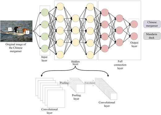
CNNs are specialised neural networks designed to process data with grid-like topology, such as images, as Figure 1. The core components of CNNs include (LeCun et al., 1998):
Convolutional layers: These layers apply convolution operations to extract local features using learnable filters (kernels).
Pooling layers: These layers reduce spatial dimensions through operations like max pooling or average pooling, enhancing computational efficiency and providing translation invariance.
Fully connected layers: These layers integrate features extracted by convolutional and pooling layers to make final predictions.
The hierarchical structure of CNNs enables them to learn increasingly abstract representations, from low-level features (e.g. edges, textures) in early layers to high-level features (e.g. complex patterns, objects) in deeper layers (LeCun et al., 2015).
CNN applications in ground subsidence prediction
CNNs have been applied to ground subsidence prediction in various ways, primarily focusing on spatial feature extraction from InSAR data. Table 2 summarises the key application categories, representative studies, and their respective contributions to the field. These applications range from artificial neural networks for mining-induced subsidence to advanced multi-scale feature extraction for land subsidence interpolation, demonstrating the versatility of CNN architectures in handling diverse spatial deformation patterns.
Advanced CNN architectures
Several advanced CNN architectures have shown potential for adaptation to ground subsidence prediction tasks. Table 3 summarises these architectures, their key characteristics, and representative studies exploring their applicability in this domain.
Strengths and limitations of CNN approaches
CNNs offer several advantages for ground subsidence prediction, yet they also face notable limitations that must be considered in practical applications. Table 4 summarises these key aspects, as discussed in the literature, providing a balanced perspective on the suitability of CNN-based methods for subsidence modelling tasks.
Recurrent neural networks and gated recurrent units
RNNs and their variants are specifically designed to handle sequential data, making them suitable for modelling temporal aspects of ground subsidence.
RNN and GRU fundamentals
RNNs process sequential data by maintaining an internal state (memory) that captures information from previous time steps. The basic RNN architecture updates its hidden state at time step t using:
where is the input at time t, and are weight matrices, is a bias term, and is an activation function.
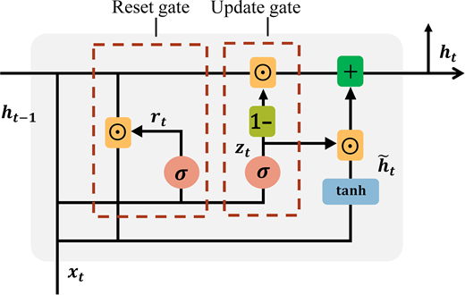
However, basic RNNs suffer from the vanishing gradient problem during training, limiting their ability to capture long-term dependencies. GRUs, introduced by Chung et al. (2014), address this issue through gating mechanisms, as shown in Figure 2:
where is the update gate, is the reset gate, is the candidate hidden state, and represents element-wise multiplication.
RNN and GRU applications in ground subsidence prediction
RNNs and GRUs have been applied to ground subsidence prediction primarily for modelling temporal dependencies. Table 5 summarises key studies demonstrating their effectiveness in various temporal forecasting tasks.
Strengths and limitations of RNN and GRU approaches
RNNs and GRUs offer several advantages for ground subsidence prediction, yet they also face notable limitations that must be considered in practical applications. Table 6 summarises these key aspects, as discussed in the literature, providing a balanced perspective on the suitability of recurrent architectures for subsidence modelling tasks.
Long short-term memory networks
LSTMs, a specialised form of RNNs, have gained significant popularity in ground subsidence prediction due to their enhanced ability to capture long-term dependencies in time-series data.
LSTM fundamentals
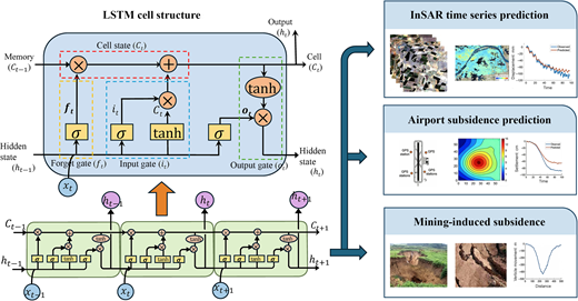
LSTMs, introduced by Hochreiter and Schmidhuber (1997), address the vanishing gradient problem through a more sophisticated gating mechanism than GRUs. The LSTM architecture includes:
Cell state: A memory component that runs through the entire sequence, allowing information to flow unchanged.
Forget gate: Controls what information to discard from the cell state.
Input gate: Determines what new information to store in the cell state.
Output gate: Controls what parts of the cell state to output.
The LSTM update equations are as follows:
where , , and are the forget, input, and output gates, respectively; is the cell state; and is the hidden state.
The specific network structure and applications of LSTM are shown in Figure 3.
LSTM applications in ground subsidence prediction
LSTMs have been widely applied to ground subsidence prediction, with numerous studies demonstrating their effectiveness across various contexts. Table 7 summarises key applications, including InSAR time-series forecasting, infrastructure monitoring, and mining-induced deformation prediction.
Advanced LSTM architectures
Several advanced LSTM architectures have been developed to enhance subsidence prediction performance. Table 8 summarises these architectures, their key characteristics, and representative studies demonstrating their effectiveness.
Strengths and limitations of LSTM approaches
LSTMs offer several advantages for ground subsidence prediction, yet they also face notable limitations that must be considered in practical applications. Table 9 summarises these key aspects, as discussed in the literature, providing a balanced perspective on the suitability of LSTM-based methods for subsidence modelling tasks.
Hybrid deep learning models
Hybrid models combine different neural network architectures to leverage their complementary strengths, particularly for capturing both spatial and temporal patterns in subsidence data.
CNN-LSTM models
CNN-LSTM models integrate CNNs for spatial feature extraction with LSTMs for temporal modelling, offering a powerful approach for spatio-temporal subsidence prediction. Table 10 summarises the key aspects of these hybrid architectures, including their structural design, representative applications, and recent enhancements reported in the literature.
Temporal convolutional gated recurrent unit (TCGRU)
Temporal convolutional gated recurrent unit (TCGRU) models combine temporal convolutional networks with GRUs to enhance feature extraction and temporal modelling. Table 11 summarises the key characteristics of this hybrid architecture, including its structural design, representative applications, and reported performance.
Other hybrid architectures
Various other hybrid architectures have been explored for ground subsidence prediction, extending beyond the CNN-LSTM and TCGRU frameworks discussed above. Table 12 summarises these alternative hybrid approaches, including their key characteristics and representative studies demonstrating their effectiveness.
Transformer models
Transformer models, originally developed for natural language processing, have recently been adapted for time-series prediction tasks, including ground subsidence forecasting.
Transformer fundamentals
Transformers, introduced by Vaswani et al. (2017), rely on self-attention mechanisms rather than recurrence or convolution:
Self-attention: This mechanism allows the model to weigh the importance of different positions in the input sequence when computing representations for each position.
Multi-head attention: Multiple attention mechanisms run in parallel, allowing the model to jointly attend to information from different representation subspaces.
Position encoding: Since Transformers lack inherent sequential processing, position encodings are added to provide information about the relative or absolute position of tokens in the sequence.
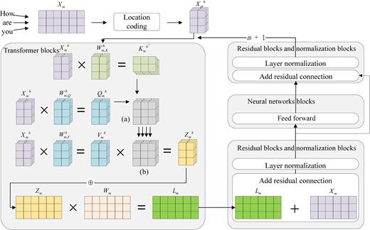
The self-attention mechanism computes attention scores as:
where Q, K, and V are query, key, and value matrices derived from the input, and is the dimension of the keys. As Figure 4 shows that the internal structure of a single Transformer block, emphasising the residual and normalisation pathways that implement the Query-Key-Value (Q, K, V matrix) computation. Input embeddings first undergo layer normalisation, after which three independent linear transformations generate query, key and value representations in parallel. These transformed vectors are then fed into the scaled dot-product attention submodule, where pairwise compatibility between queries and keys is evaluated and used to weight the corresponding value vectors. The resulting contextualised vectors are re-injected into the residual stream, layer-normalised once more, and finally forwarded to the feed-forward sub-layer. Throughout this pipeline, the Q, K, and V signals are manipulated solely through normalisation, linear projection, compatibility scoring, value weighting and residual addition, thereby encapsulating the attention mechanism within a stabilising residual-and-normalisation wrapper.
Transformer applications in ground subsidence prediction
While Transformers are relatively new in the ground subsidence prediction domain, several recent studies have explored their potential. Table 13 summarises these applications, categorising them by their focus and highlighting key contributions.
Strengths and limitations of transformer approaches
Transformers offer several advantages for ground subsidence prediction, yet they also face notable limitations that must be considered in practical applications. Table 14 summarises these key aspects, as discussed in the literature, providing a balanced perspective on the suitability of Transformer-based methods for subsidence modelling tasks.
Comparative analysis of deep learning methods
DL has rapidly become a central paradigm for ground subsidence prediction, enabling the modelling of complex non-linear relationships between geological, hydrological, and deformation variables directly from observational data. However, the performance and suitability of different DL architectures vary substantially depending on the spatial-temporal characteristics of the subsidence process, data availability, and computational resources. The most widely employed architectures include CNNs, RNNs and their variants (LSTMs, GRUs), and Transformer-based models, each offering distinct advantages in spatial representation, temporal modelling, and computational scalability.
CNNs have proven particularly effective for capturing spatial dependencies in subsidence phenomena. By applying convolutional kernels to grid-based datasets such as InSAR or satellite-derived deformation maps, CNNs can automatically extract hierarchical spatial features that represent deformation patterns, fault structures, or geological boundaries. This ability makes them especially suitable for tasks involving spatial interpolation or the mapping of subsidence extent over large regions (Wu et al., 2023a). However, CNNs operate under a fixed receptive field and often lack the capacity to explicitly model long-range spatial interactions, which may limit their accuracy when subsidence is influenced by distant or regional processes such as basin-scale fluid extraction or tectonic loading. To overcome this limitation, attention-based models such as Transformers have been introduced, offering the flexibility to capture both local and global spatial dependencies through self-attention mechanisms (Wang et al., 2023). These models have demonstrated promising results in learning non-local deformation correlations that are difficult for conventional CNNs to represent.
Temporal modelling poses an equally important challenge in subsidence prediction, as the evolution of surface deformation reflects time-dependent processes such as consolidation, groundwater fluctuation, or mining progression. Recurrent architectures-including LSTMs and GRUs-are specifically designed to model sequential dependencies in time-series data (Gao et al., 2019). LSTMs, with their gated memory mechanisms, are particularly adept at learning long-term dependencies and delay effects, making them well-suited for forecasting subsidence at individual monitoring points over extended periods (Soni et al., 2025). GRUs, while conceptually similar, offer a simpler structure and reduced computational burden, often achieving comparable performance in short- to medium-term predictions (Chen et al., 2024). More recently, Transformer models have begun to rival recurrent networks in temporal forecasting, as their attention mechanisms allow for parallelised training and efficient learning of long-range temporal dependencies without the vanishing-gradient issues typical of RNNs (Wu et al., 2023b). Nonetheless, Transformers generally require larger datasets and careful optimisation, which may constrain their application in regions with limited observational records (Liu and Zhang, 2023).
For spatio-temporal prediction tasks-such as forecasting regional subsidence patterns over time-hybrid architectures have emerged as the most effective solutions. Models that combine CNNs with recurrent or attention-based layers (e.g. CNN-LSTM, CNN-Transformer) can simultaneously learn spatial deformation structures and temporal evolution patterns, leveraging the strengths of both model types (Seo and Lee, 2021; Wang et al., 2023). These hybrid frameworks have achieved state-of-the-art performance in multiple studies, demonstrating improved generalisation and robustness compared to single-architecture models. Furthermore, ensemble learning strategies, which integrate multiple DL architectures or combine DL with traditional statistical models, can enhance prediction stability and reduce model variance (Zhao et al., 2023). A growing trend also involves embedding physical constraints or domain knowledge into DL models-so-called PINNs-to ensure physically consistent predictions and mitigate overfitting, particularly when data are sparse or noisy (Gong et al., 2025).
Despite their remarkable predictive capabilities, DL approaches face several fundamental challenges that constrain their widespread adoption in geotechnical and geological engineering. One of the most pressing issues is interpretability: DL models typically act as ‘black boxes’, making it difficult to trace their internal decision logic or relate latent representations to physically meaningful parameters (Gong et al., 2025). This opacity limits trust in their predictions and hampers their use in regulatory or engineering decision making contexts. Generalisation also remains problematic, as models trained on specific regions or geological settings may not perform well when applied to new areas with different lithological or hydrological characteristics (Chen et al., 2021). Furthermore, most current DL frameworks provide deterministic outputs without quantifying prediction uncertainty, an essential factor for risk-informed planning and hazard mitigation (Wu et al., 2023a).
Addressing these challenges has become an active area of research. Current efforts focus on developing interpretable and physics-informed architectures, integrating multi-source datasets (e.g. InSAR, GPS, borehole, and hydrogeological data), and incorporating Bayesian or ensemble methods for uncertainty quantification. The integration of geomechanical knowledge with data-driven learning promises to improve both the robustness and physical interpretability of DL models, paving the way towards next-generation frameworks that are not only accurate but also explainable, transferable, and reliable for practical ground subsidence prediction and management.
Method comparison and analysis
This section provides a comprehensive comparison between traditional and DL methods for ground subsidence prediction, analysing their relative strengths, limitations, and applicability across different scenarios. We establish a systematic evaluation framework, present quantitative and qualitative comparisons, and examine representative case studies to provide insights into method selection for various subsidence prediction challenges.
Evaluation metrics and comparison framework
To facilitate a systematic comparison of prediction methods, we consider several key evaluation dimensions:
Prediction accuracy metrics
Quantitative assessment of prediction accuracy typically employs the following metrics:
Root mean square error (RMSE): Measures the average magnitude of prediction errors, giving higher weight to larger errors:
Mean absolute error (MAE): Measures the average magnitude of errors without considering their direction:
Coefficient of determination (): Indicates the proportion of variance in the dependent variable explained by the model:
Nash–Sutcliffe efficiency (NSE): Assesses the predictive power of models relative to using the mean of observed data:
represents observed values, represents predicted values, is the mean of observed values, and n is the number of observations.
Computational efficiency metrics
Evaluating computational efficiency is essential for assessing the practical feasibility and scalability of ground subsidence prediction models, particularly as datasets grow in size and complexity. Unlike traditional empirical or analytical models, which are typically lightweight and easy to compute, modern numerical simulations and DL architectures often demand substantial computational resources. Accordingly, several interrelated metrics are commonly used to quantify computational performance and guide model selection.
The first and most direct indicator is training time, which measures the duration required for model calibration or parameter optimisation. For DL frameworks, training time depends not only on dataset size and network depth but also on hardware configuration and optimisation strategy. Models such as CNNs and RNNs can require extensive training iterations to converge, particularly when dealing with large-scale spatio-temporal datasets. Reducing training time through parallel computation, transfer learning, or adaptive learning rate scheduling is therefore an active area of research aimed at improving model practicality in real-world engineering applications.
Closely related to training efficiency is inference time, referring to the computational duration needed to generate predictions once the model has been trained. While training typically occurs offline, inference determines the model’s operational responsiveness in applications such as real-time monitoring or early warning systems. Lightweight architectures, such as GRUs or pruned CNNs, generally exhibit faster inference than more complex models like Transformers, making them preferable for near-real-time forecasting scenarios. Optimising inference efficiency is particularly critical when integrating DL models into decision-support systems that require rapid updates as new observational data become available.
Another key dimension of computational efficiency is memory utilisation, which reflects the amount of computational resources required for model storage and execution. Deep networks often contain millions of parameters, and their deployment can strain available GPU or CPU memory, especially when processing large input grids or long temporal sequences. Techniques such as model compression, weight quantisation, and low-rank approximation have been explored to reduce memory consumption without sacrificing predictive accuracy. Efficient memory management not only enhances portability but also lowers the computational cost, enabling deployment in resource-limited environments or edge computing frameworks.
Finally, scalability represents the ability of a model to maintain reasonable computational performance as the size of the input data or the spatial extent of the study area increases. This property is particularly important in subsidence prediction, where regional-scale analyses may involve millions of pixels or decades of time-series observations. Numerical models often face exponential increases in computational cost with spatial resolution, whereas DL methods – especially those designed for distributed or parallel processing – offer greater scalability. Transformer architectures, for example, can process large datasets efficiently through parallel attention mechanisms, although their quadratic memory complexity still poses challenges for extremely large inputs.
Overall, computational efficiency metrics provide an essential basis for comparing traditional and DL approaches in subsidence prediction. They not only reflect algorithmic performance but also determine the feasibility of model integration into real-time or large-scale monitoring systems. Balancing predictive accuracy with computational economy remains a central goal for the next generation of predictive frameworks, where advances in hardware acceleration, algorithmic optimisation, and data management will play a decisive role in enabling operational deployment.
Applicability metrics
The practical applicability of ground subsidence prediction methods extends beyond accuracy and computational performance; it encompasses the broader question of how effectively a model can be implemented and generalised in real-world scenarios. Assessing applicability therefore requires a multidimensional evaluation of data demands, generalisation ability, interpretability, uncertainty quantification, and implementation complexity. These metrics collectively determine whether a method can transition from research to operational practice in engineering, environmental monitoring, or urban planning contexts. A comparative summary of these applicability metrics across different methodological categories is presented in Table 15, providing a concise overview of their respective strengths and limitations.
A primary determinant of applicability is the data requirement, which defines the quantity, quality, and diversity of input data necessary for effective model operation. Traditional empirical models typically depend on historical monitoring records and thus require dense, long-term datasets for calibration. Analytical and numerical methods, by contrast, rely on detailed geological, hydrological, and geomechanical information to parameterise subsurface properties. DL approaches impose a different form of data dependency: they thrive on large, high-quality datasets for training but can perform poorly when data are scarce, noisy, or spatially inconsistent. Consequently, the success of a chosen method is often contingent on data availability and reliability, emphasising the importance of data preprocessing, fusion, and augmentation in modern predictive frameworks.
Closely related to data dependency is the generalisation capability, which reflects a model’s robustness when applied to new regions, different geological environments, or time periods beyond the training conditions. Empirical and site-specific analytical models often suffer from poor generalisation because their parameters or empirical relationships are tied to local conditions. In contrast, numerical and DL models can potentially generalise better if they are properly regularised and trained on sufficiently diverse datasets. However, overfitting remains a common issue in data-driven approaches, where a model may capture spurious patterns specific to the training data rather than the underlying physical processes. Evaluating generalisation performance – through cross-regional testing, temporal validation, or transfer learning – is thus critical for ensuring reliability in practical applications.
Another key dimension of applicability lies in model interpretability, referring to the extent to which model outputs and internal representations can be understood, explained, and trusted by domain experts. Physics-based methods, such as analytical and numerical simulations, are inherently interpretable since their parameters and governing equations have direct physical meanings. In contrast, DL architectures often behave as opaque ‘black boxes’, making it challenging to link latent features to tangible geomechanical processes. Recent efforts to improve interpretability – through attention visualisation, saliency mapping, or integration of physical constraints – are therefore crucial for fostering confidence and adoption in geoscientific decision making.
In addition to interpretability, uncertainty quantification has become an indispensable component of model applicability. Predictive uncertainty arises from various sources, including measurement noise, parameter estimation errors, and model structural limitations. Traditional approaches often address uncertainty through sensitivity analysis or probabilistic modelling, while contemporary data-driven methods increasingly employ Bayesian neural networks, ensemble learning, or Monte Carlo dropout techniques to generate probabilistic forecasts. Reliable uncertainty quantification is particularly important in risk-sensitive domains such as infrastructure design, groundwater management, and urban safety, where decision making must be guided not only by central predictions but also by their associated confidence intervals.
Finally, the implementation complexity of a prediction method plays a decisive role in determining its practical adoption. Analytical and empirical models are generally simple to implement, requiring limited computational resources and expertise, which makes them attractive for preliminary assessments or resource-constrained applications. In contrast, numerical simulations and DL models demand substantial domain knowledge, computational infrastructure, and technical expertise for model construction, calibration, and validation. The growing use of open-source software frameworks, cloud-based computation, and automated workflows is helping to reduce these barriers, yet implementation complexity remains a major factor in determining whether a method can be sustainably maintained in operational settings.
In summary, the applicability of ground subsidence prediction methods depends on balancing data demands, generalisation, interpretability, uncertainty management, and implementation feasibility. Methods that achieve an optimal trade-off among these factors – by combining physical insight with data-driven adaptability – are likely to offer the greatest potential for real-world deployment. As the field advances, future research should focus on developing hybrid frameworks that are not only accurate and efficient but also interpretable, transferable, and operationally practical across diverse geological and environmental contexts.
Traditional methods versus deep learning methods
Prediction accuracy comparison
Comparative evaluations of prediction accuracy across diverse subsidence scenarios reveal clear distinctions between traditional and DL-based methods. In regions characterised by simple and stable subsidence patterns, where geological and hydrogeological conditions are relatively well understood, traditional analytical and numerical approaches remain highly competitive. When properly calibrated, these physics-based models can achieve accuracy levels comparable to those of modern DL architectures, owing to their firm grounding in established geomechanical principles and physical interpretability (Chen et al., 2021; Peng et al., 2019). However, as the complexity of subsidence dynamics increases – particularly in heterogeneous or non-linear geological settings – the limitations of traditional approaches become more apparent. DL models, particularly those employing hybrid architectures that integrate spatial and temporal feature extraction, have demonstrated a clear performance advantage in such contexts (Li et al., 2024; Soni et al., 2025). For example, Chen et al. (2024) reported that hybrid DL models yielded improvements of approximately 15%–30% compared with traditional methods when applied to regions exhibiting complex, multi-mechanism subsidence processes. A comparative summary of prediction accuracy across different methodological categories is presented in Table 16, which highlights the relative strengths and limitations of each approach for simple versus complex subsidence patterns, as well as for temporal and spatial prediction tasks.
Temporal forecasting accuracy exhibits similar trends. LSTM-based architectures generally outperform traditional time-series models by effectively capturing long-range dependencies and non-linear temporal interactions inherent in ground deformation data (Bao et al., 2022; Ding et al., 2021). In many cases, these models achieve error reductions of 20%–40% relative to conventional statistical or physically simplified approaches. On the spatial dimension, DL models that leverage CNNs show superior performance for subsidence interpolation and extrapolation tasks. CNN-based methods have consistently outperformed geostatistical techniques such as kriging, particularly in areas with complex or discontinuous spatial deformation features (Azarm et al., 2024).
Overall, while traditional models remain valuable for well-characterised and physically constrained environments, DL approaches exhibit superior adaptability and predictive power in scenarios dominated by non-linear, coupled, and data-rich dynamics. The observed improvements in prediction accuracy underscore the growing potential of DL as a powerful complement – not merely a replacement – to established subsidence prediction frameworks.
Computational efficiency comparison
The computational efficiency of ground subsidence prediction methods varies considerably across methodological categories, reflecting differences in model formulation, data demands, and computational workflows. Traditional empirical and analytical approaches are typically lightweight in terms of computational requirements. Their development relies primarily on statistical fitting or closed-form mathematical formulations, which can be implemented and executed with minimal computational resources. As such, these methods are particularly advantageous in situations demanding rapid assessments or operational deployment over large spatial domains with limited computational infrastructure (Galloway and Leake, 2016).
In contrast, numerical modelling techniques-such as finite element and finite difference simulations-demand substantially greater computational resources, especially when addressing three-dimensional, coupled hydro-mechanical processes. These models often involve large-scale discretisation, iterative convergence algorithms, and the solution of complex non-linear systems of equations. Consequently, their computational cost grows rapidly with problem size and model resolution, making high-performance computing environments essential for regional or long-term simulations (Peng et al., 2019).
DL models, while computationally demanding during the training phase, exhibit a distinct advantage in prediction efficiency once trained. Model training often involves optimisation over large datasets and high-dimensional parameter spaces, requiring substantial GPU or distributed computing resources. However, after training, the inference process-that is generating predictions from new input data-is typically much faster than running equivalent numerical simulations. This makes DL particularly attractive for real-time or near-real-time monitoring applications, where rapid prediction updates are necessary (Chen et al., 2024). Moreover, DL architectures demonstrate better scalability for large-scale or high-resolution prediction tasks, as the computational burden during inference scales linearly with input size and can be parallelised efficiently (Li et al., 2024; Wang et al., 2023).
Overall, while traditional approaches excel in simplicity and computational efficiency, numerical and DL methods trade higher computational cost for increased predictive capability and flexibility. The balance between model complexity, training requirements, and prediction efficiency is therefore a key consideration when selecting an appropriate method for specific engineering or environmental applications.
Data requirements comparison
Data requirements represent one of the most decisive factors influencing the practical feasibility of different ground subsidence prediction methods. Traditional empirical approaches generally rely on moderate amounts of historical monitoring data, such as surface deformation records or well-level measurements, but demand minimal auxiliary geological information (Whittaker et al., 1991). These methods therefore offer rapid implementation where long-term observation data are available, albeit at the expense of reduced generalisability across regions with distinct geological settings. In contrast, analytical and numerical modelling techniques – particularly those based on hydrogeomechanical formulations – require a comprehensive characterisation of the subsurface environment, including parameters such as permeability, compressibility, and layer stratigraphy (Galloway and Leake, 2016; Gambolati et al., 2000). The collection and calibration of these parameters can be resource-intensive, posing significant challenges for large-scale or data-poor regions.
By comparison, DL methods shift the data burden from physical parameters to observation-driven datasets. Their effectiveness depends on the availability of extensive, high-quality monitoring data for model training, such as InSAR time series or continuous GPS measurements (Chen et al., 2021; Soni et al., 2025). While these models can often achieve robust performance even without explicit knowledge of the underlying physical processes, their data appetite increases with model complexity. Architectures such as CNNs or LSTMs perform effectively with moderate datasets, whereas Transformer-based frameworks typically require substantially larger data volumes to achieve stable convergence and generalisation (Wu et al., 2023b). Overall, the choice of method thus reflects a trade-off between the availability of physical versus observational data, determining the most practical and sustainable modelling strategy for a given application context.
Applicability comparison
The practical applicability of ground subsidence prediction methods is shaped by a complex interplay of geological, data-related, and methodological factors. Traditional physics-based approaches generally perform well in regions with relatively homogeneous and well-characterised geological settings, where model parameters such as stratigraphy, compressibility, and permeability can be accurately determined. In contrast, DL methods demonstrate greater adaptability and robustness in complex or heterogeneous environments, where subsurface structures are poorly understood and physical models may oversimplify reality (Chen et al., 2024).
Data availability is another decisive factor influencing model applicability. In regions with abundant monitoring data but limited geological characterisation-such as urban areas with dense InSAR or GNSS observations-data-driven DL models often achieve superior predictive performance. Conversely, in areas where geological and hydrogeological data are abundant but long-term monitoring records are sparse, physics-based analytical or numerical methods remain more reliable for capturing the governing deformation processes (Galloway and Leake, 2016; Li et al., 2023).
The prediction horizon further differentiates the strengths of various methods. Traditional approaches tend to perform adequately for short-term forecasts under stable conditions, where system dynamics remain relatively consistent. However, long-term or non-stationary scenarios, particularly those involving evolving environmental or anthropogenic influences, typically benefit from DL approaches capable of capturing complex temporal dependencies and non-linear trends (Bao et al., 2022; Soni et al., 2025).
Interpretability and uncertainty quantification also play crucial roles in determining practical applicability. Traditional physics-based models offer transparent causal interpretations and well-established frameworks for uncertainty estimation, which are valuable for decision making in engineering and environmental management (Gambolati et al., 2000). DL models, while often criticised as ‘black boxes’, have seen growing progress in interpretability and uncertainty-aware modelling through attention visualisation, feature attribution, and probabilistic inference techniques (Gong et al., 2025; Wu et al., 2023a). These developments are gradually bridging the gap between predictive accuracy and physical insight, enhancing the potential of DL methods for operational deployment.
Comparison among deep learning methods
DL architectures have demonstrated substantial potential for modelling the highly non-linear, spatio-temporal dynamics of ground subsidence. However, their performance characteristics vary considerably depending on the model type, data modality, and application objectives. A comparative understanding of these architectures is therefore crucial for selecting an appropriate model in practical applications. A comprehensive summary of the major DL architectures and their comparative characteristics for ground subsidence prediction is provided in Table 17, which highlights the trade-offs among spatial feature learning, temporal dependency modelling, model complexity, and predictive stability.
Spatial feature extraction capabilities
The ability to extract spatial features is a defining factor in the effectiveness of DL models for subsidence prediction. CNNs have proven particularly adept at learning multi-scale spatial representations from grid-structured data, such as InSAR-derived deformation maps. Advanced CNN architectures-including U-Net, ResNet, and DenseNet-excel at capturing both local and global spatial dependencies, making them well suited for identifying complex deformation patterns and spatial heterogeneity in subsurface processes (Azarm et al., 2024; Wang and Shi, 2024).
In contrast, RNNs and their variants, such as LSTMs and GRUs, were originally designed for sequential data and lack inherent mechanisms for spatial feature extraction. When applied to spatial data, they typically rely on preprocessing steps or integration with convolutional components to achieve meaningful spatial representation (Chen et al., 2023).
Transformers, which employ attention mechanisms and positional encodings, provide an alternative framework for learning spatial relationships. While they are capable of capturing non-local dependencies, their performance in grid-based spatial prediction tasks often lags behind that of CNNs in terms of computational efficiency and fine-grained spatial resolution (Zhang et al., 2024). Hybrid architectures – such as CNN-LSTM or CNN-GRU – combine the spatial perception of CNNs with the temporal memory of recurrent networks, achieving a balanced and often superior performance in spatio-temporal prediction scenarios (Seo and Lee, 2021; Yang et al., 2022).
Temporal dependency modelling
Temporal dependency modelling is essential for understanding cumulative deformation processes and long-term subsidence evolution. Standard CNNs, though powerful for spatial feature learning, are limited in capturing temporal dynamics unless extended into temporal convolutional networks (TCNs) that use dilated convolutions to model sequential dependencies (Zhang et al., 2022).
RNNs were originally designed for such sequential tasks but often suffer from vanishing gradient problems, restricting their effectiveness to short-term dependencies (Chen et al., 2021). LSTMs address these limitations by introducing gating mechanisms that preserve long-term information, making them particularly effective for capturing sustained deformation trends in long time series (Ma et al., 2023; Soni et al., 2025). GRUs, a simplified variant of LSTMs, offer comparable long-term modelling ability with fewer parameters and greater training efficiency (Chen et al., 2024).
Transformers represent a paradigm shift in temporal modelling by discarding recurrence altogether and relying on attention mechanisms to directly capture long-range dependencies across time. This global receptive field allows Transformers to outperform recurrent architectures in very long sequences, although they typically require more extensive datasets and careful regularisation to avoid overfitting (Wu et al., 2023b; Zhou et al., 2021). Overall, LSTMs remain the most robust choice for medium-term predictions, while Transformers show clear advantages for large-scale, data-rich, and long-horizon forecasting tasks.
Model complexity and training challenges
The complexity of a DL model directly influences its trainability, computational demands, and deployment feasibility. CNNs are generally easier to train than recurrent or attention-based architectures due to their feedforward nature and extensive optimisation experience accumulated in computer vision research. Nonetheless, very deep CNNs may suffer from vanishing gradient issues, which are typically mitigated through residual connections and batch normalisation (Li and Papyan, 2023).
RNNs and GRUs exhibit moderate training difficulty, with GRUs offering a favourable trade-off between model complexity and performance stability. LSTMs, despite their superior representational power, are more challenging to optimise effectively because of their larger parameter count and internal gating structure, often necessitating sophisticated initialisation, gradient clipping, and learning rate scheduling strategies (Soni et al., 2025).
Transformers are particularly demanding in this regard: they require large memory resources and are sensitive to hyperparameter tuning, batch size, and learning rate scheduling (Wu et al., 2023a). Hybrid and ensemble architectures, while often delivering state-of-the-art performance, further increase the training burden because they must coordinate multiple components (e.g. CNN for spatial features, LSTM for temporal sequences) in a unified optimisation process (Chen et al., 2024; Seo and Lee, 2021). Consequently, practical applications must carefully balance model complexity against computational feasibility and data availability.
Prediction stability and generalisation
Prediction stability and generalisation represent critical performance dimensions for subsidence forecasting models, determining their reliability across different spatial regions and temporal conditions. CNNs generally exhibit stable behaviour for spatial interpolation within the training domain but often struggle to extrapolate beyond the spatial distribution of the training data, particularly in geologically diverse environments (Azarm et al., 2024).
RNNs, LSTMs, and GRUs provide relatively robust temporal generalisation for steady subsidence processes but may fail to capture abrupt regime shifts caused by external factors such as groundwater extraction or tectonic events (Ding et al., 2021; Li et al., 2024). Transformers, with their global attention mechanisms, tend to generalise better to complex, non-stationary patterns when sufficient training data are available (Wu et al., 2023b).
Recent advances have shown that ensemble and hybrid approaches can substantially enhance prediction stability by combining complementary model strengths and mitigating individual weaknesses (Kariminejad et al., 2024). Physics-informed neural networks (PINNs) represent another promising direction, embedding domain-specific physical constraints into the learning process. By integrating data-driven learning with physics-based regularisation, PINNs improve both generalisation and interpretability, bridging the gap between traditional and DL paradigms (Kim et al., 2023).
Case studies
Examining representative case studies provides essential empirical validation of predictive models and illuminates how different methodologies perform across diverse subsidence contexts. The following examples – spanning mining, urban, groundwater-related, and regional-scale subsidence – demonstrate the evolution from traditional mechanistic models towards DL and hybrid architectures capable of capturing complex spatio-temporal deformation dynamics.
Mining-induced subsidence prediction
Mining-induced subsidence remains among the most challenging scenarios for predictive modelling due to its abrupt onset, highly localised deformation patterns, and strong dependence on underground excavation geometry. In a comprehensive study conducted in a copper mining region of India, Soni et al. (2025) compared multiple modelling frameworks using InSAR time-series data to evaluate predictive accuracy across varying temporal horizons. Traditional influence function methods achieved reasonable agreement with observed deformation, yielding values of and RMSE around mm/year. However, these classical approaches were limited by their reliance on simplified geometric assumptions and lack of adaptability to dynamic mining conditions.
RNNs demonstrated modest improvements (, RMSE mm/year) but struggled with long-term dependencies intrinsic to cumulative deformation processes. Standard LSTM architectures substantially enhanced predictive capability (, RMSE mm/year), effectively capturing non-linear temporal dependencies between mining operations and surface response. Notably, an attention-augmented LSTM achieved the highest accuracy (, RMSE mm/year), reducing prediction error by more than 40% relative to traditional methods. The superiority of DL in this case was attributed to its ability to learn latent non-linear mappings directly from observational data, bypassing the need for detailed subsurface characterisation that often constrains physically based models.
Urban subsidence prediction
Urban subsidence presents a multifactorial challenge, arising from the interplay of groundwater extraction, excessive building loads, and heterogeneous geological conditions. In a study of Kunming City, China, Chen et al. (2024) utilised SBAS-InSAR data to compare the predictive performance of several modelling strategies. Classical time-series decomposition approaches achieved moderate accuracy ( between 0.70 and 0.80), effectively capturing broad temporal trends but failing to reproduce the non-linear and spatially variable deformation observed in densely built environments.
DL approaches, particularly GRU-based models, improved predictive fidelity () by capturing complex interdependencies between successive deformation states. The most advanced architecture evaluated – the Multi-Component Temporal Convolutional GRU (MC-TCGRU) – further integrated multi-scale temporal decomposition with recurrent modelling, achieving consistent accuracy levels of across multiple test locations. This approach proved particularly effective in regions where deformation dynamics were influenced by seasonal groundwater variations and heterogeneous construction loads. The study demonstrated that hybrid models combining signal decomposition with deep neural architectures can capture both deterministic and stochastic components of urban ground motion, offering a powerful framework for monitoring rapidly developing cities.
Groundwater-related subsidence prediction
Groundwater extraction remains one of the most pervasive causes of large-scale land subsidence, particularly in agricultural basins where aquifer depletion drives gradual yet extensive deformation. In their analysis of the North China Plain, Yang and Zhang (2022) evaluated a range of predictive methods to quantify the relationship between groundwater level fluctuations and surface subsidence. Physically based poroelastic models achieved baseline performance (RMSE mm/year), but their predictive accuracy depended heavily on detailed hydrogeological characterisation and calibration.
DL models provided a more flexible alternative. Standard LSTMs achieved improved accuracy (RMSE mm/year) by capturing time-lagged relationships between extraction rates and surface displacement. Further gains were achieved by CNN-LSTM hybrid architectures (RMSE mm/year), which explicitly modelled both spatial and temporal dependencies within the data. This integration proved crucial for heterogeneous aquifer systems, where spatial variability in lithology and hydraulic conductivity strongly modulates local deformation responses. The study underscored the importance of spatio-temporal coupling in subsidence prediction and demonstrated how deep neural models can effectively encode non-linear hydromechanical interactions that are difficult to express analytically.
Regional-scale subsidence prediction
At regional scales, subsidence prediction must address challenges related to spatial heterogeneity, data volume, and computational efficiency. Zhang and Xu (2024) conducted an extensive investigation of hydrological and environmental dynamics in the Yangtze River Basin, offering critical insights into the large-scale interactions between surface water systems, land deformation, and anthropogenic drivers. Through long-term monitoring of surface water variations, the study produced a high-resolution spatio-temporal dataset that enables integrated modelling of water balance, sediment transport, and associated ground deformation processes.
Their analysis revealed that hydrological variability – driven by both climatic fluctuations and human interventions – exerts a dominant control on basin-scale land motion. By combining remote sensing observations with DL techniques, the study demonstrated that data-driven approaches can effectively capture the non-linear relationships between hydrological processes and surface deformation over extended temporal scales. The methodological framework and analytical insights developed for the Yangtze Basin provide a valuable reference for applying similar integrated monitoring and modelling strategies in other large-scale subsiding regions worldwide.
Method selection guidelines
Selecting an appropriate ground subsidence prediction method requires a nuanced consideration of data availability, geological characteristics, spatial-temporal dynamics, and the practical significance of prediction outcomes. In well-understood and geologically homogeneous regions where monitoring data are scarce, traditional analytical or numerical methods remain highly effective. These approaches leverage established physical models to compensate for limited data, ensuring interpretability and reliability in stable conditions (Gambolati et al., 2000). However, as the complexity of subsidence mechanisms increases and spatial heterogeneity becomes more pronounced, purely physics-based models often struggle to capture non-linear interactions and coupled processes inherent in real-world systems.
In contrast, data-rich environments characterised by intricate and evolving subsidence patterns favour DL-based approaches. Architectures such as CNN-LSTM and MC-TCGRU have demonstrated superior performance in capturing both spatial and temporal dependencies, achieving substantial improvements in predictive accuracy compared to traditional methods (Chen et al., 2024; Seo and Lee, 2021). For prediction tasks primarily concerned with spatial variability – such as deformation mapping or hotspot detection – CNN-based models, or hybrid schemes that combine geostatistical interpolation with deep feature extraction, have proven particularly effective (Azarm et al., 2024; Wang and Shi, 2024). Conversely, when temporal dynamics dominate, recurrent neural architectures, especially LSTM networks with attention mechanisms or bidirectional structures, offer superior capability in modelling long-term temporal dependencies (Soni et al., 2025; Wang et al., 2023).
At regional or continental scales, where both spatial and temporal processes interact in complex ways, spatio-temporal hybrid architectures such as CNN-LSTM models or Transformer-based networks emerge as the most promising solutions. These models can simultaneously encode multi-dimensional dependencies and adapt to dynamic conditions across large and heterogeneous domains (Yang et al., 2022; Zhang et al., 2024). In high-stakes applications – such as infrastructure stability assessment or subsidence-related disaster prevention – ensemble learning approaches integrating multiple models often provide enhanced robustness and improved uncertainty quantification (Kariminejad et al., 2024). Such ensemble strategies reduce individual model bias and help maintain stability under varying geological or data conditions.
For novel geological settings or regions with limited historical monitoring data, emerging paradigms such as PINNs and transfer learning approaches provide an effective compromise between data efficiency and predictive accuracy. By embedding domain knowledge or leveraging pretrained representations from related regions, these methods can achieve reliable performance even under constrained data conditions (Franczyk et al., 2022; Kim et al., 2023).
Ultimately, the optimal subsidence prediction strategy is rarely singular. Hybridisation – combining data-driven learning with physical insight – represents the most promising direction for future development. As monitoring technologies continue to evolve and computational resources expand, integrated frameworks that merge physical modelling, DL, and uncertainty quantification are likely to define the next generation of subsidence prediction systems, offering both improved accuracy and enhanced interpretability.
A concise summary of the recommended prediction methods under different subsidence scenarios is provided in Table 18, highlighting the practical decision framework for model selection in real-world applications.
Future research directions and prospects
As research on ground subsidence prediction continues to evolve, a convergence between physics-based and data-driven paradigms is becoming increasingly apparent. Future advances will likely depend on developing hybrid methodologies that integrate the interpretability and physical consistency of traditional models with the flexibility and predictive power of modern ML. In parallel, progress in multi-source data fusion, model interpretability, and uncertainty quantification will redefine the frontier of predictive accuracy and reliability in this field.
Method integration and hybrid approaches
The most promising direction for future subsidence modelling lies in the integration of physics-based principles with data-driven learning. Among these hybrid paradigms, PINNs represent a particularly compelling approach. By embedding physical laws – such as poroelasticity, consolidation mechanics, and fluid–solid coupling – directly into the neural network training process, PINNs bridge the gap between empirical learning and theoretical understanding. Such integration allows the models to extrapolate beyond the training data while maintaining physical plausibility, which is crucial for predicting subsidence in dynamically evolving geological environments. Future work should focus on developing subsidence-specific PINN frameworks capable of representing multi-physics interactions, such as groundwater depletion, soil compaction, and surface deformation, within a unified computational architecture. Furthermore, the incorporation of probabilistic reasoning, for instance through Bayesian PINNs, could enable uncertainty-aware predictions that better inform decision making in risk-sensitive applications.
Closely related to hybridisation is the growing potential of transfer learning and domain adaptation. Many subsidence-prone regions suffer from sparse or inconsistent monitoring records, which hinder the direct training of deep models. Transfer learning offers a mechanism to leverage knowledge acquired from data-rich regions and adapt it to new sites with limited data availability. This approach not only improves generalisation but also reduces the cost of data acquisition. A particularly promising research avenue involves embedding physical constraints within transfer learning pipelines to ensure that transferred representations remain consistent with fundamental subsidence processes rather than purely data-driven correlations. This combination of physics-guided adaptation and cross-regional learning could significantly enhance the scalability and robustness of predictive systems.
Data fusion and multi-source integration
Future advances in ground subsidence prediction will also depend heavily on the capacity to integrate diverse and heterogeneous data sources. Remote sensing technologies, in particular, have transformed the monitoring of surface deformation. However, each modality – such as InSAR, GPS, and LiDAR – has distinct strengths and limitations. The fusion of multi-sensor observations promises to exploit the spatial precision of InSAR, the temporal continuity and three-dimensional capability of GPS, and the high-resolution mapping potential of LiDAR. Advanced fusion algorithms capable of harmonising these complementary datasets could yield continuous, high-fidelity spatiotemporal representations of ground deformation dynamics. In addition, combining multiple SAR frequencies (X-, C-, and L-bands) may further enhance sensitivity to deformation over varied land cover types and geological conditions, mitigating the limitations inherent in single-sensor approaches.
Beyond remote sensing, the inclusion of auxiliary datasets such as hydrogeological and geotechnical information will be pivotal. Groundwater levels, extraction rates, and aquifer properties provide crucial physical context for interpreting observed subsidence patterns. Similarly, detailed stratigraphic and soil-mechanical data can constrain predictive models and prevent non-physical extrapolations. The challenge ahead lies in designing data assimilation frameworks that can effectively integrate these multi-scale, multi-type datasets – each with distinct spatial resolutions and uncertainties-into a coherent predictive system.
Model enhancement and innovation
In addition to hybridisation and data integration, several methodological innovations are poised to advance the state of subsidence prediction models. One of the most critical areas is model interpretability. While DL models often achieve remarkable accuracy, their ‘black-box’ nature limits trust and acceptance in engineering and policy contexts. Enhancing interpretability through mechanisms such as attention visualisation can provide insight into how models weigh different spatial or temporal features when making predictions. Complementary techniques such as unified feature importance analysis or surrogate modelling can further reveal the internal reasoning processes of complex networks, enabling practitioners to validate and refine model behaviour based on domain expertise.
Equally vital is the development of robust uncertainty quantification frameworks. Accurate uncertainty estimation underpins risk-informed decision making, particularly in infrastructure management and groundwater exploitation. Bayesian DL offers a principled approach to quantify both aleatoric (data-driven) and epistemic (model-related) uncertainties. Ensemble learning, where multiple diverse architectures are trained and their outputs aggregated, can provide an empirical approximation of uncertainty by assessing prediction variance. More recently, conformal prediction has emerged as a promising direction for distribution-free uncertainty quantification, providing rigorous confidence bounds even under model misspecification – an attractive property for real-world subsidence applications.
Finally, the emergence of novel architectures and learning paradigms provides fertile ground for innovation. Graph neural networks, for instance, offer a natural framework for modelling spatial dependencies and irregular monitoring networks, capturing the inherent topological structure of geological formations and fault systems. Likewise, neuro-symbolic AI approaches hold potential for integrating human knowledge and logical constraints into predictive pipelines, thereby enhancing interpretability and robustness. Self-supervised learning also represents an exciting development, allowing models to pretrain on large volumes of unlabelled remote sensing data before fine-tuning on limited annotated datasets. This paradigm could substantially reduce the dependency on costly labelled data while retaining high predictive performance.
Associative memory networks
Associative memory networks have garnered increasing attention in recent years, particularly following the demonstration of the equivalence between HNNs and Transformers in the work of Ramsauer et al. (2020). Owing to their inherent associative memory capabilities, HNNs have shown strong explanatory power across a variety of application scenarios. In this context, Krotov and Hopfield (2016) proposed the dense associative memory (DAM) model, which was later shown to possess a memory capacity that scales polynomially with the network size N (Bao et al., 2022). Building upon this, Lucibello and Mézard (2024) introduced a novel variant of DAM characterised by an exponential memory capacity in terms of the number of hidden neurons. This was achieved through the adoption of a threshold-based non-linearity, enabling both high storage capacity and large basins of attraction, as substantiated by theoretical analyses and numerical experiments.
Furthermore, the Universal Hopfield Network (UHN) framework has been developed to unify various single-shot associative memory models. This general framework enhances memory capacity and retrieval performance by reformulating the energy function and refining the update rules. More recently, Chaudhry et al. (2023) proposed the Long-Sequence Hopfield Memory (LSHM) model, which is specifically designed to improve the storage and retrieval of long sequences. By optimising both the energy landscape and dynamic update mechanisms, LSHM achieves superior capacity and retrieval stability compared to classical Hopfield models. This model is also considered to hold significant promise for applications such as subsidence prediction, among other temporal pattern recognition tasks.
Application expansion and practical implementation
The practical implementation of ground subsidence prediction methods marks a crucial frontier in bridging scientific advancement and societal resilience. As methodological sophistication increases, translating these techniques into operational systems capable of real-time monitoring, regional-scale forecasting, and multi-hazard management becomes both a challenge and an opportunity.
One promising direction involves the development of real-time monitoring and early warning systems that leverage advances in edge computing and anomaly detection. The rapid proliferation of Internet of Things sensors, combined with high-resolution remote sensing data, provides unprecedented opportunities for continuous subsidence surveillance. By integrating edge computing architectures, data can be processed directly at or near the monitoring site, minimising latency and enabling near-instantaneous detection of deformation events (Shi et al., 2016). Such systems would be particularly valuable in high-risk areas – such as urban centres, coastal deltas, or mining regions – where early warnings could mitigate economic loss and ensure public safety. Complementing this technological foundation, unsupervised and semi-supervised learning models can autonomously identify anomalous patterns or deviations from normal ground movement (Pang et al., 2021), offering a robust mechanism for detecting emerging hazards without the need for extensive labelled datasets.
Another avenue for practical expansion lies in regional-scale prediction. As the spatial extent and complexity of subsidence-prone zones continue to grow, particularly in large sedimentary basins or groundwater-dependent agricultural regions, the demand for scalable, computationally efficient models becomes pressing. Hierarchical or multi-resolution modelling frameworks offer a viable solution, allowing coarse-grained regional predictions to guide local high-resolution refinements in areas of elevated risk (Zhang and Xu, 2024). The increasing availability of distributed computing platforms and cloud-based geospatial analytics tools, such as Google Earth Engine (Gorelick et al., 2017), further facilitates this scalability, enabling the simultaneous processing of petabyte-scale satellite datasets and complex numerical simulations. In addition, as subsidence phenomena frequently extend across administrative or national borders, the development of harmonised frameworks for cross-border data integration will be essential (Castellazzi et al., 2016). Such coordination would ensure consistent monitoring, improve model interoperability, and support cooperative management of shared groundwater resources.
A further critical frontier is the integration of subsidence prediction into multi-hazard assessment frameworks. Subsidence rarely occurs in isolation – it often interacts with other geohazards such as flooding, landslides, or infrastructure degradation. In low-lying coastal or deltaic environments, land subsidence exacerbates flood risks by reducing surface elevation and impeding drainage, necessitating coupled models that capture subsidence–flood interactions (Wang et al., 2021). Similarly, linking subsidence predictions with infrastructure vulnerability assessments can help identify critical risk zones for roads, pipelines, and buildings (Peduto et al., 2017), thereby informing urban planning and maintenance strategies. Beyond immediate hazards, climate change represents a long-term forcing mechanism that must be incorporated into predictive frameworks. Changing precipitation patterns and groundwater recharge dynamics may alter subsurface hydro-mechanical behaviour, intensifying subsidence in some regions while stabilising it in others (Herrera-García et al., 2021). Integrating climate projections into subsidence forecasting will therefore be essential for developing adaptive management strategies that remain robust under future environmental uncertainty.
Challenges and opportunities
Despite recent advances, several overarching challenges continue to constrain the full realisation of intelligent, operational subsidence prediction systems. Foremost among these is data accessibility and standardisation. While the proliferation of remote sensing missions has vastly expanded observational capacity, data remain fragmented across agencies, platforms, and formats (Morishita et al., 2020). Establishing open repositories and standardised metadata frameworks would enable more systematic comparative analyses, facilitate reproducibility, and accelerate the development of transferable prediction models. The open-science paradigm has already transformed adjacent fields such as climate modelling and hydrology; extending it to subsidence research could yield similar collective benefits.
A second challenge concerns computational infrastructure. The high dimensionality and temporal granularity of modern monitoring data, coupled with the complexity of hybrid physical-data-driven models, demand substantial computational resources. Advances in high-performance computing, distributed cloud frameworks, and specialised hardware such as GPUs and TPUs are gradually overcoming these limitations (Gorelick et al., 2017). As these technologies mature, real-time regional-scale prediction and continuous model updating will become increasingly feasible. Nevertheless, maintaining computational efficiency while preserving model interpretability remains an open research question, particularly when integrating multi-physics constraints or uncertainty quantification modules.
The evolution of subsidence prediction into an operational science also depends critically on interdisciplinary collaboration. Effective solutions will require cooperation among geoscientists, hydrologists, computer scientists, civil engineers, and policymakers (Galloway and Leake, 2016). Only through such collaboration can models be both scientifically rigorous and practically actionable, integrating domain-specific knowledge with algorithmic innovation. Furthermore, the communication of predictive uncertainty and model limitations to decision-makers must become a routine part of the research workflow, ensuring that scientific outputs translate into informed and responsible management decisions.
Finally, the growing influence of AI in subsidence prediction introduces the need for responsible and transparent AI practices. The deployment of AI-driven systems in environmental monitoring must adhere to principles of accountability, fairness, and sustainability (Floridi et al., 2018). Models should be interpretable enough to support human oversight, robust to data shifts and biases, and designed with clear ethical guidelines for data usage. Addressing these concerns will not only strengthen public trust but also ensure that AI contributes constructively to sustainable land and water management.
Collectively, these challenges and opportunities define the next frontier of ground subsidence research. By advancing methodological integration, expanding data accessibility, enhancing computational infrastructures, and fostering cross-disciplinary and ethical collaboration, the field is poised to transition from isolated predictive studies towards comprehensive, operational frameworks. These future systems will not only predict ground deformation with higher accuracy but will also empower communities and governments with actionable insights for mitigating subsidence risks and safeguarding infrastructure resilience in an increasingly dynamic Earth system.
Conclusion
This review has provided a comprehensive examination of ground subsidence prediction methods, spanning from traditional approaches to cutting-edge DL techniques. By systematically analysing the evolution, principles, strengths, and limitations of various prediction methodologies, we have established a foundation for understanding the current state of the art and identifying promising future directions in this critical field.
Research status summary
The landscape of ground subsidence prediction has undergone significant transformation over the past two decades, characterised by several key developments:
Traditional methods evolution: Empirical, analytical, and numerical methods have formed the foundation of subsidence prediction for decades. These approaches have continuously evolved, with improvements in influence function formulations, more sophisticated poroelastic models, and advanced numerical simulation techniques. Despite their limitations in handling complex non-linear patterns and computational demands, these methods continue to provide valuable physical insights and remain essential tools, particularly in well-characterised geological settings with limited monitoring data (Peng et al., 2019).
Deep learning emergence: The past decade has witnessed the rapid rise of DL approaches in subsidence prediction. From early applications of basic neural networks to sophisticated architectures like CNNs, LSTMs, and Transformers, these methods have demonstrated remarkable capabilities in capturing complex spatio-temporal patterns directly from monitoring data. The progression from single-architecture models to hybrid approaches like CNN-LSTM and MC-TCGRU reflects the growing sophistication of DL applications in this domain (Chen et al., 2021, 2024; Li et al., 2024; Soni et al., 2025).
Integration trends: Recent research has increasingly focused on integrating traditional physical understanding with data-driven approaches, as exemplified by physics-informed neural networks and hybrid modelling frameworks. This integration represents a promising direction for combining the complementary strengths of different methodological families (Kariminejad et al., 2024; Kim et al., 2023).
Data source expansion: The evolution of prediction methods has been closely tied to advancements in monitoring technologies, particularly the widespread adoption of InSAR for large-scale, high-resolution subsidence monitoring. The integration of multiple data sources, including remote sensing, ground-based measurements, and auxiliary information, has enhanced both traditional and DL approaches (Bitelli et al., 2014; Castellazzi et al., 2016).
Comparative analyses across diverse subsidence scenarios have revealed that while DL methods generally offer superior prediction accuracy for complex, non-linear patterns, traditional methods maintain advantages in interpretability, physical consistency, and applicability in data-scarce environments. The optimal approach often depends on specific characteristics of the subsidence phenomenon, available data, and prediction requirements, highlighting the importance of method selection based on context-specific considerations (Chen et al., 2021, 2024).
Deep learning potential and challenges
DL approaches have demonstrated transformative potential for ground subsidence prediction, yet their practical deployment is accompanied by significant challenges. Table 19 provides a concise summary of the key potential benefits and inherent limitations associated with these methods, as discussed in the literature. This overview facilitates a balanced understanding of the opportunities and obstacles that shape the current and future application of DL in this domain.
Future outlook
The future of ground subsidence prediction lies at the intersection of traditional physical understanding and advanced data-driven approaches. Table 20 summarises the key research directions that are expected to shape the evolution of this field, as identified in recent literature. These directions encompass methodological innovations, data integration strategies, and cross-disciplinary collaborations that together promise to enhance predictive accuracy, robustness, and practical applicability.
These developments will be facilitated by continuing advances in computational infrastructure, data accessibility, and standardisation efforts that support more comprehensive and reproducible research.
Final remarks
Ground subsidence represents a significant and growing global hazard, with impacts on infrastructure, water resources, flood risk, and community safety. Accurate prediction of subsidence patterns is fundamental to effective risk assessment, mitigation planning, and sustainable development in vulnerable regions.
The evolution from traditional physics-based approaches to sophisticated DL methods has dramatically expanded our predictive capabilities, particularly for complex subsidence scenarios. However, the most promising path forward lies not in choosing between these methodological families but in their thoughtful integration-combining the physical understanding embedded in traditional approaches with the pattern recognition power of DL.
By addressing current challenges in data availability, model interpretability, uncertainty quantification, and generalisation, the next generation of subsidence prediction methods can provide more accurate, reliable, and actionable information to support decision making. This advancement will contribute significantly to reducing subsidence-related risks and enhancing resilience in the face of this pervasive geological hazard.
As monitoring technologies continue to improve and computational capabilities expand, the field of ground subsidence prediction stands at the threshold of a new era – one characterised by increasingly sophisticated, integrated approaches that leverage both physical principles and data-driven insights to better understand and forecast this complex phenomenon.
Statements and declarations
Author contributions
K. Mo and Y. Li wrote the main manuscript draft; J. Zhang supervised the research project and have totally rectified all the paper; B. Min have checked the paper and provided some funding support. All authors reviewed the final manuscript.