

ABPmer, in collaboration with the GeoData Institute, has developed an online research tool on behalf of the UK Department for the Environment, Food and Rural Affairs. The project was financed by the Aggregate Levy Sustainability Fund, Marine Environmental Protection Fund and has created a database of research project information relating to marine aggregate extraction. The online system has been designed to maximise user benefit through improved ‘knowledge management’, and has been tailored to address scientific as well as policy needs. Users can now access this comprehensive body of marine aggregate research through a specially designed website: www.marinealsf.org.uk. The website holds a ‘live’ register of research studies contained within a spatial metadata-base and, where available, supplies direct access to PDF research reports. The documented research is primarily marine-aggregates based but also includes data from other relevant sectors of interest. The system incorporates a web-enabled geographical information system to support user queries and help identify geographic areas that are research rich or poor.
1. PROJECT OVERVIEW
In September 2004 the UK Centre for Environment, Fisheries and Aquaculture Science (CEFAS) awarded the Marine Environment Protection Fund (MEPF) 04/07 Marine ALSF GIS project to a team comprising ABP Marine Environmental Research Ltd (ABPmer) and the GeoData Institute. The purpose of the project is to ensure that marine aggregate research provides maximum benefit and addresses policy needs through an improvement in ‘knowledge management’.
The project provides access to past and current marine aggregate research through a website (www.marinealsf.org.uk) which holds a live register of research and, where available, supplies direct links to research outputs. The research in the system may be directly related to marine aggregates or associated to another sectoral interest; it may offer a UK context or be developed from a relevant overseas study. The database is designed to recognise planned, current and past activities with associated funding bodies and research institutes. The use of geographic information systems (GIS) is included to provide a means of assisting search facilities and determining geographic areas which may be research rich or poor. The project also provides a valuable tool for disseminating information from other Aggregate Levy Sustainability Fund (ALSF) research programmes.
It is understood that many web-based facilities exist which host or sell spatial data (commonly in GIS format) to define a multitude of marine environmental parameters. It is not intended for the Marine ALSF GIS to replicate or compete with these data delivery sites. The main driver for the present project is to provide information about contemporary research studies related to marine aggregates.
2. SYSTEM DEVELOPMENT
At the start of the project a user specification study was undertaken during which a range of potential end-user groups were consulted about the functionality of the proposed system. The outputs from this activity were used to create a technical specification for the system development. Further detail about these activities can be found in specialist reports that are available from the publications page of the project website. The technical specification was used to guide the project developments, which include a database that has been populated with aggregate research project information (metadata) which includes data about the who, where, what, when, and why for each study, which was collated from industry, regulators and other consultancy sources. The website combines text searches with information from the webGIS to support the searching and retrieval of marine aggregate research project metadata and associated reports, as demonstrated in Fig. 1. It also provides functionality for the remote update of new project metadata and associated deliverables by registered users. The website was launched in March 2007.
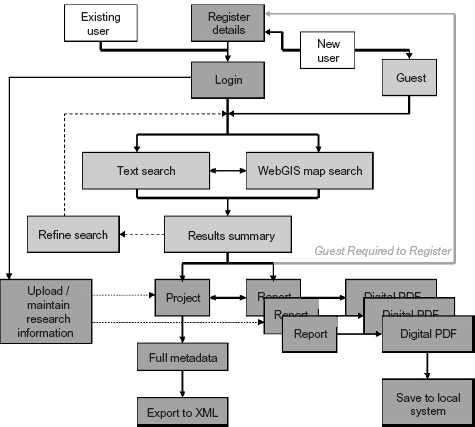
All of the development conforms to the standards published by the Open GIS Consortium (OGC) and ensures that there will be no cost for software packages, server or client licences, support or upgrades for the final system. This also means that no special client-side technologies are required to view information at the browser end and the whole system is fully portable between computer hardware of different organisations.
3. INPUTS
The ALSF GIS study has sourced information from completed research projects and captured details into a structured database. This information is stored as metadata including an abstract, contacts, history and spatial extent for each project record. Where the digital project deliverable report is available it has also been obtained and made accessible either as a digital PDF document, a website reference or a library location. Summary information about these reports is stored as a bibliographic record and is linked to a project record in the system. Each individual research project record may have zero to many report references yet each report record only has one mandatory ‘parent’ project record.
All relevant aggregate projects have been considered; however, the database is focused on research from within UK waters completed since the year 2000. This has helped to maximise the availability of relevant project metadata and digital deliverables held within the system. Information from current marine aggregate projects has also been entered into the database. This project information conforms to the UK geo-spatial metadata interoperability initiative (Gemini) specification that has been adopted to standardise the metadata stored within the database.
4. OUTPUTS
The primary project deliverable is a customised website (www.marinealsf.org.uk) providing the tools to search and retrieve aggregate project metadata. Initially the website content provided general marine ALSF GIS project information, as well as a user forum, and this has developed into a data catalogue of research studies as the project progressed. The research project information is accessed through a helpful front-end including an intuitive search facility with provision for standard bibliographic keywords (title, abstract, date, project leader, project distributor) and an option for visual ‘by map location’ data queries. Direct links to digital project reports are also provided for user download where available.
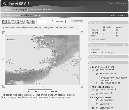
The visual search facility is presented using a web-enabled geographic information system, as demonstrated in Fig. 2. This includes several key base-mapping layers (aggregate licence blocks, coastline, general sea areas, bathymetry, coastal places) to enable users to search and place results in a map. This helps to rapidly identify areas that are rich/poor in research from particular topics or themes. Interactive text help is also implemented to guide new users through the functionality of the system. Initial searches can be undertaken without registering on the website; however, users are required to register log-on to the system prior to receiving any detailed metadata or portable document format (PDF) reports (Fig. 3) thus enabling the monitoring of both user groups and downloads from the database.

Registered users are also able to add references about their current research projects into the database by completing online forms which only require limited checking by a nominated administrator before being included in the live system. Further functionality facilitates the upload of user project reports into the system to accompany their project metadata records. This enables the dissemination of project information to a wider community and also ensures that the database will remain as a contemporary resource after the project has been completed. It is also anticipated that this functionality will provide a valuable tool for disseminating information from other current and potential future marine aggregate research programmes.
5. END USERS
The primary project deliverable is aimed at improving the management of information and digital documents rather than advancing our scientific/technical understanding of marine aggregates. A summary of potential users and associated benefits are presented in Table 1. The database provides an additional support vehicle to assist wider dissemination from other ALSF and non-ALSF funded research with the overall benefit of improved take-up of all the research.
Potential users of the marine ALSF GIS database
| Department for the Environment, Food and Rural Affairs (Defra) | Improve coordination of sectoral funding. |
| Maximise benefits of available funds by targeting research to priorities. | |
| Supporting policy requirements. | |
| Achieving public access to environmental information (Environmental Information Regulations) and freedom of information. | |
| Other funders | Maximise benefits of available funds by targeting research to priority themes and spatial locations. |
| Identifying other research programmes and researchers to help avoid duplication of effort. | |
| Marine aggregate industry | More readily identify available research to improve their own scientific/technical understanding. |
| Improve linkages to other sectors. | |
| Improve access to information for prospecting and associated activities. | |
| Provide a primary location for information from ALSF and other aggregate research programmes. | |
| Researchers | More readily identify available research to improve their own scientific/technical understanding. |
| Become more identifiable as contributors to research. | |
| Improve linkages within the wider research community. | |
| Identify potential funding bodies. | |
| Respond better to research calls. | |
| Regulators | Identify status of present knowledge. |

