
1-20 of 5228
Keywords: ORGANIC
Close
Follow your search
Access your saved searches in your account
Would you like to receive an alert when new items match your search?
Journal

Covers the effect of civil engineering on local communities.
Journal Articles
Proceedings of the Institution of Civil Engineers - Municipal Engineer 1–12.
Published: 08 September 2026
in A QGIS-based assessment of wind energy potential in US forests: an experiment in Oregon
> Proceedings of the Institution of Civil Engineers - Municipal Engineer
Published: 08 September 2026
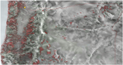
Figure 1. QGIS overlay depicting the extent of private forest ownership in Oregon (in red), with the state’s wind speeds calculated at 100 m (black to white gradient w/white as high quality wind). In the top-left, the yellow dot identifies the location of a proposed wind farm for this analysis ... More about this image found in QGIS overlay depicting the extent of private forest ownership in Oregon (i...
in A QGIS-based assessment of wind energy potential in US forests: an experiment in Oregon
> Proceedings of the Institution of Civil Engineers - Municipal Engineer
Published: 08 September 2026
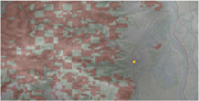
Figure 2. Private forest ownership west of Scappoose, Oregon, visualising the overlap of viable wind locations with private ownership A Map of the St Helens area shows mapped land-cover blocks, the Columbia River corridor, and a marked site near Scappoose. The map depicts the area around Scapp... More about this image found in Private forest ownership west of Scappoose, Oregon, visualising the overlap...
in A QGIS-based assessment of wind energy potential in US forests: an experiment in Oregon
> Proceedings of the Institution of Civil Engineers - Municipal Engineer
Published: 08 September 2026
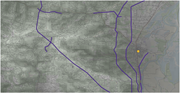
Figure 3. Electric transmission lines and forest roads around proposed wind farm location outside Scappoose, Oregon A Map of the Scappoose area showing a marked site, dense drainage lines, roads and several prominent linear boundaries. The map depicts the Scappoose area and surrounding terrain... More about this image found in Electric transmission lines and forest roads around proposed wind farm loca...
in A QGIS-based assessment of wind energy potential in US forests: an experiment in Oregon
> Proceedings of the Institution of Civil Engineers - Municipal Engineer
Published: 08 September 2026
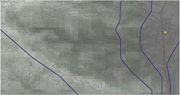
Figure 4. Proposed series of wind turbines along NW Dixie Mountain Road outside Scappoose A Map of the Scappoose area showing a marked site, drainage networks, prominent linear boundaries and several smaller point locations. The map depicts the Scappoose area and surrounding terrain. A circu... More about this image found in Proposed series of wind turbines along NW Dixie Mountain Road outside Sca...
in A QGIS-based assessment of wind energy potential in US forests: an experiment in Oregon
> Proceedings of the Institution of Civil Engineers - Municipal Engineer
Published: 08 September 2026
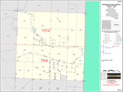
Figure 5. Washington County Assessment and Taxation Records showing land ownership at the proposed site A Map of Washington County Oregon Section 33 showing tax lots, parcel acreages, roads, section references and assessment details. The cadastral map shows Washington County, Oregon, Section 3... More about this image found in Washington County Assessment and Taxation Records showing land ownership at...
in A QGIS-based assessment of wind energy potential in US forests: an experiment in Oregon
> Proceedings of the Institution of Civil Engineers - Municipal Engineer
Published: 08 September 2026
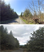
Figure 6. Example of forest roads near NW Dixie Mountain Road by the Doppler Weather Station outside Scappoose, Oregon (Credit: Google Earth) Two photos show narrow rural roads bordered by dense trees and vegetation under clear and cloudy skies. The upper view shows a straight unpaved road r... More about this image found in Example of forest roads near NW Dixie Mountain Road by the Doppler Weathe...
Journal Articles
Proceedings of the Institution of Civil Engineers - Municipal Engineer 1–18.
Published: 04 September 2026
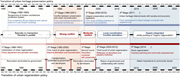
... no intersection and Develop in parallel. This changes to Strong conflict, followed by Moderate conflict, then Local coordination and Conflict alleviation, and finally Deeply integrated, jointly pointing to organic regeneration. The urban regeneration trajectory comprises five stages. The 1st stage, from 1980...
in Heritage community identity of Shanghai Shikumen Lanes: institutional economic renewal
> Proceedings of the Institution of Civil Engineers - Municipal Engineer
Published: 04 September 2026
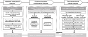
Figure 1. Progressive research process A three-stage framework progresses from historical institutional analysis to dual-track comparison and two-dimensional matrix analysis. The framework follows three stages from Historical institutional analysis to Dual-track system comparative analysis and... More about this image found in Progressive research process A three-stage framework progresses from his...
in Heritage community identity of Shanghai Shikumen Lanes: institutional economic renewal
> Proceedings of the Institution of Civil Engineers - Municipal Engineer
Published: 04 September 2026
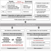
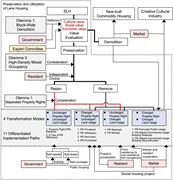
Figure 2. Dilemma analysis of SLH A framework presents three dilemmas in Shikumen Lane Housing involving property rights, demolition, and high-density mixed occupancy. The framework centres on Shikumen Lane Housing, S L H, and presents three dilemmas and their associated institutional condit... More about this image found in Dilemma analysis of SLH A framework presents three dilemmas in Shikume...
in Heritage community identity of Shanghai Shikumen Lanes: institutional economic renewal
> Proceedings of the Institution of Civil Engineers - Municipal Engineer
Published: 04 September 2026
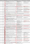
Figure 3. Interpretation of relevant policies and stage division of the urban regeneration system A timeline table traces Shanghai urban regeneration policies and their significance across two stages from 1980 to 2000. The timeline table contains 34 numbered entries with the columns Date, Docu... More about this image found in Interpretation of relevant policies and stage division of the urban regener...

in Heritage community identity of Shanghai Shikumen Lanes: institutional economic renewal
> Proceedings of the Institution of Civil Engineers - Municipal Engineer
Published: 04 September 2026
Figure 4. Interpretation of relevant policies and stage division of the heritage preservation system A timeline table traces Shanghai's modern building preservation policies through three stages from 1982 to 2005. The timeline table contains 24 numbered entries with the columns Date, Document,... More about this image found in Interpretation of relevant policies and stage division of the heritage pres...
in Heritage community identity of Shanghai Shikumen Lanes: institutional economic renewal
> Proceedings of the Institution of Civil Engineers - Municipal Engineer
Published: 04 September 2026
integrated, jointly pointing to organic regeneration. The urban regeneration trajectory comprises five stages. The 1st stage, from 1980 to 1991, is Initialization of urban regeneration, characterised by Policy adjustment and sporadic renovation. During this period, renovation is dominated by government More about this image found in The interactive relationship of the dual-track system A comparative time...
in Heritage community identity of Shanghai Shikumen Lanes: institutional economic renewal
> Proceedings of the Institution of Civil Engineers - Municipal Engineer
Published: 04 September 2026
Figure 6. Negotiation platform among stakeholders A framework presents preservation and utilisation of lane housing through value evaluation, four transformation modes and 11 implementation paths. The framework presents Preservation and Utilization of Lane Housing centred on S L H and links id... More about this image found in Negotiation platform among stakeholders A framework presents preservatio...

in Crash modification factors for Sonepat using empirical Bayes and negative binomial modelling
> Proceedings of the Institution of Civil Engineers - Municipal Engineer
Published: 26 August 2026
Figure 1. Road segments: (a) narrow median, (b) wide median, (c) no shoulder, and (d) different junction types Four panels compare roads with a narrow median, a wide median, no shoulder, and different junction types. The panel a presents a divided road with a narrow median separating the oppos... More about this image found in Road segments: (a) narrow median, (b) wide median, (c) no shoulder, and (d)...
Journal Articles
Proceedings of the Institution of Civil Engineers - Municipal Engineer 1–13.
Published: 26 August 2026
... challenges worldwide. Road traffic injuries are the eighth leading cause of death globally, with over 1.35 million people dying of their injuries each year according to the World Health Organisation (Ahmed et al., 2023 ; Alobaidallah et al., 2025 ; Geduld et al., 2024 ; Mohammed...
in Transportation simulation and stakeholder exercises for urban seismic resilience
> Proceedings of the Institution of Civil Engineers - Municipal Engineer
Published: 28 July 2026
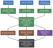
Figure 1. Integrated methodological framework for urban seismic resilience planning (case study: St. Louis) A flowchart shows the workflow for earthquake evacuation traffic simulation and planning recommendations. The flowchart begins with three input sources. Household survey with n of 149 re... More about this image found in Integrated methodological framework for urban seismic resilience planning (...
in Transportation simulation and stakeholder exercises for urban seismic resilience
> Proceedings of the Institution of Civil Engineers - Municipal Engineer
Published: 28 July 2026
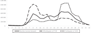
Figure 2. Evacuation demand profiles used to represent baseline conditions and earthquake-triggered demand surges for 07:00 and 16:00 events A line graph compares hourly evacuation demand for baseline conditions and earthquakes occurring at 07.00 and 16.00. The horizontal axis represents time ... More about this image found in Evacuation demand profiles used to represent baseline conditions and earthq...

in Transportation simulation and stakeholder exercises for urban seismic resilience
> Proceedings of the Institution of Civil Engineers - Municipal Engineer
Published: 28 July 2026
Figure 3. St. Louis metropolitan region: priority evacuation and response corridors used in the case study A map identifies the study area, priority routes, and reference information for the St. Louis metropolitan region. The map covers the St. Louis metropolitan region with latitude from 38.2... More about this image found in St. Louis metropolitan region: priority evacuation and response corridors u...

