In the Netherlands, there is a practice of entrepreneurs who buy land, fragment it into tiny parcels and sell it using aggressive marketing campaigns for extremely high prices to private people suggesting that this is a fine investment, because of expected planning gain. However, usually, this land has no prospect for development at all being often situated in areas that have no development perspective at all. Furthermore, the speculative shredding of land makes it unfit for future uses. This paper aims to explore whether the legal systems of Nordic countries (Denmark, Finland, Norway and Sweden) with regard to subdivision, can help to address this issue of speculative land fragmentation, and it explores the potential of Nordic experiences for including some of these principles in the legal system of the Netherlands.
The comparative study is based on study of relevant documents and legal materials, studies and expert interviews.
Denmark, Norway and Sweden have each a system that will not allow speculative land fragmentation in the ways it appears in the Netherlands. The way these systems are organised differs, with a central role of a private surveyor (Denmark), the municipality (Norway) or a national agency (Sweden). Finland has a system that will not prevent subdivision outside areas that are planned for construction.
Different alternative ways are discussed on how the experiences from the Nordic countries can be used to change the Netherlands system.
The speculative land fragmentation in the Netherlands is a rather new phenomenon and there is no previous publication on the ways how learning from Nordic countries may provide options to prevent it.
1. Introduction
In the Netherlands, a practice of land shredding for speculative purposes has developed. Certain profit-driven property agents buy farmland, split it into very small plots and sell these, for very high prices and using aggressive marketing strategies, to private individuals suggesting that this is a wise investment in scarce land. The Kadaster (Wisman and Zuidema, 2024) estimates that there were about 25,000 investment parcels on 700 locations in the Netherlands in 2023, and that this figure grows with about 3,000 parcels a year. Usually, these locations are not in areas where any housing is projected: there is no development foreseen. Private individuals pay a lot more for this land than any professional party would do. Van Zadelhoff (2022), a land steward, has published a case on the appraisal for the purpose of the inheritance tax of the legacy of “Uncle Piet” who had bought 26 of those investment parcels for €1.3m. However, Van Zadelhoff appraised the parcels to a value of only €65,000. It occurs that many buyers seem not to be halted by buyer beware procedures (Rheinfeld and de Jager, 2023; Waye et al., 2024) that oblige professional agents, like the notary and the selling property agents, to warn buyers for the risky nature of their purchases.
In addition to the fact that the areas of fragmented land parcels are often located in areas that will never be developed (for example, a protected landscape area or close to a noisy road), the fragmentation itself blocks the possibilities for future development. These areas may continue to stay outside regular urban development management processes as these are, considering the price paid, economically not fit anymore for any professional development activity, and alternative development, as part of a sustainable development vision, are not foreseen in the deals with the owners. The transaction costs to buy these lands, even by compulsory purchase which includes paying legal costs for the owners, are excessive. This is a stalemate which is likely to hold on for decades. It is not easy to consolidate shredded lands. So, it can be expected that these speculative land parcels are there to stay as a specific and enduring class of land use outside the reach of spatial planning.
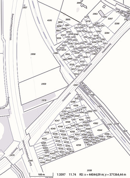
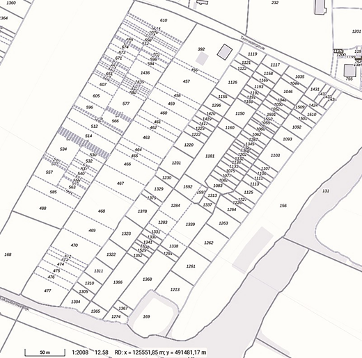
In the Netherlands there are no legal restrictions for owners who aim to split a parcel of land. The most common procedure is that an owner requests a notary to make a deed. For cadastral purposes the notary draws a temporary boundary using the application SPLITS of the Kadaster (Bartels et al., 2013). The idea is that after the transaction has taken place, a definitive parcel will be formed based on the measurement by a surveyor employed by the Kadaster who uses the deed and is supported by directions of the owners in the field. However, in the case of shredded lands, buyers do not visit or use their lands and cannot point out where the borders are. Usual practice is that the land will be jointly used by a farmer and that no boundaries whatsoever are visible in the field. As the Kadaster has no opportunity to produce definitive parcels, the cadastral boundaries will stay temporary (Figures 1 and 2), which has another negative impact on the marketability of the lands (Kadaster, 2023; Visser and Pavillon, 2024).
In the Netherlands’ subdivision procedure there is no test whether new parcels are efficient or whether they meet the proposed use of the parcel; it is the owners prerogative to split the parcel if they wish to do so. The notary has a public function and cannot refuse to make a deed if owners request them to do so (Rheinfeld, 2023; Rheinfeld and de Jager, 2023). Land use planning provisions cannot steer this process as the notary does not have to consider whether proposed parcels are in line with foreseen land uses. Full ownership of land is not considered to be an investment product, that means, that transactions are not supervised by the financial market authority. Local authorities issue warnings to citizens not to step into this practice (Abid, 2024) but that is about the only thing they can do.
In this context a debate has emerged on policy responses to this issue. In the Nordic countries there is a system in which planning steers the formation of land parcels. This paper investigates whether lessons from the Nordic countries (Denmark, Finland, Norway and Sweden) can be used to change the system in the Netherlands in a way that land shredding can be prevented. In the next section literature on speculation and land fragmentation is introduced, then methodology and context are presented, the system in the Nordic countries is presented, the relevance of this for uptake in the Netherlands is discussed and the paper is concluded.
2. Speculation and land fragmentation
There is a long tradition of debate on land speculation in relation to planning and housing production (Eberstadt, 1894; George, 1879; Pierson, 1905). This early literature relates land speculation to the immediate production of housing and other properties and discusses the impact of land speculation on housing production also in relation to the affordability and the question of the production of affordable housing or setting land aside to wait for better prices (Jolles, 1906), i.e. the “temporary withholding of land from the market” (Pierson, 1913, p. 139).
An important principle is that land values change in anticipation to expectations of future uses and that market agents act in anticipation to these changes. This rise of the price of land does not wait until formal planning designations have changed. Depending on the context, the formal change of land designation may have an impact as well on the price. One of the issues in value capturing is the expectation management in relation to market values. Alternatively, if planning policies are completely transparent to the market, there may be no increase caused by planning decisions at all:
If there has been speculation or front-running, the uplift in value expected as a result of a legislated density increase or air rights permission may already have been capitalized into a land price; it may then be argued that the new owner’s “unearned increment” is zero and that the developer cannot both offer a contribution to the public sector and realize competitive returns (Wolf-Powers, 2023, p. 1747).
This relationship with formal planning decisions is part of the definition of Stanley (2015) who defines speculation “as maintaining ownership of land to profit explicitly from political economic changes affecting local land values” (Stanley, 2015, p. 574). This specific focus on public processes is because “urban land speculation is often predicated upon leveraging value gains triggered by public investment and government power” (Stanley, 2015, p. 565). Sites in inner city areas are so central that public actors may use taxpayers’ money to reuse the sites for a new purpose. Stanley shows that landowners show extraordinary patience and that “many vacant properties have been singularly owned for decades” (Stanley, 2015, p. 577). Another form of speculation found by Stanley in Phoenix, AZ, is “speculation based on lobbying for zoning entitlements or other regulatory changes from government that increase land values” (Stanley, 2015, p. 577). Some of these where presenting themselves as real developers but in fact their “business was solely focused on ‘repositioning’ and ‘promoting’ the property to other buyers” (Stanley, 2015, p. 578). This lobbying for strategic locations where development companies have some land ownership is one of the normal operations of property developers (Leffers and Wekerle, 2019).This is also the case in the Netherlands (Buitelaar et al., 2024). In many contexts, land use regulations are conservative and primarily regulate current land uses and change is necessary to allow building.
A well-known strategy by developers is to buy land early (or timely), that is long before local land use plans allow development. From an acquisition point of view this is often necessary. If you do not buy this land timely, another agent will do so. However, the price paid for this land, makes it essential that the local land use plan must change. An important activity for local landowners is in this respect to lobby for changes of land use rights. Logan and Molotch (2007, 1ed., 1987) consider this the work of “structural speculators”, that is, entrepreneurs who […]:
[…] do not rely solely on their capacity to estimate future locational trends; they supplement such intelligence by intervening in that future (Logan and Molotch, 2007, 1ed. 1987, p. 30).
These entrepreneurs speculate on their ability to change the relationships of a given place to other places – that is, they attempt to determine the patterns through which others will seek users’ values from place. One of the matters they engage in is to “lobby for or against specific zoning and general plan designations” (Logan and Molotch, 2007, 1ed., 1987, p. 31). According to Leffers (2018) developers are quite successful in this, especially in the case study of Toronto: “Developers seem to be more able than other actors (such as environmentalists) in influencing planning and land use change.” (Leffers, 2018, p. 3071).
Leffers explains this based on three factors. Firstly, there is a mutual dependency. Developers need not only planning to change designated land use, but planners also need developers that are willing to develop their plans. Secondly, developers may contribute to election campaigns of politicians that are supporting their cases. Thirdly, as few developers are influential enough to make a real impact they organise themselves in industrial organisations with a strong lobby impact because “associations are more able to communicate with the Province as a single, powerful, unified voice than are individual developers” (Leffers, 2018, p. 3071). There are indeed well-known and influential developer associations, such as NEPROM in the Netherlands (Fokkema, 2020; Rijken et al., 2020), the Fédération des promoteurs immobiliers in France (Pollard, 2023), the LPDF in the UK (Shepherd et al., 2024), which are generally lobbying for more greenfield development at the types of sites their members have a position.
In the UK, which does not have as-of-right producing local land use plans, but in which planning permission is a discretionary decision of the local planning authority—making that in almost all planning applications it is uncertain whether these will be provided, a specific actor has developed being that of the “land promotor” (Jones and Comfort, 2020; McAllister et al., 2023; Shepherd et al., 2024). For a long time, land development and property development have been executed by the same companies in the UK. In the past “[…] developer-builders frequently build up large strategic land banks and, because of their size, have a significant influence in the residential land market itself” (Ball, 2003, p. 912). However, since the Global Financial Crisis, many of the house development companies have stopped to be active in holding extensive portfolios of potential building land (McAllister et al., 2023), which is a very capital intensive undertaking. Land promotion companies have stepped into this gap. Land promotors do not own the land and so need less capital upfront:
The business models of land promoters are built around using their expertise and resources to drive a development site through the often complex, risky and uncertain planning process. In effect, they take on and commodify planning risk in return for a share of development value, which is crystallised by the grant of planning permission (Shepherd et al., 2024, p. 1917).
This context is ever changing, and the large risk involves makes that these actors are generally financed based on equity and less on debt. Lenders considers it often too risky (Shepherd et al., 2024).
The success of strategic landowners and land promotors in this context can be explained by “The logic of collective action” (Olson, 1965), which indicates that in a democratic society minorities with a high stake in a matter can get things done at the expense of a majority in which each person individually is less affected by the matter (compare England, 2018).
Next to this connection with development, there are also landowners that speculate only in the phases before development takes place. Stanley sees in Phoenix a property market “where the exchange value of land is increasingly divorced from tangible use value, and where speculation can begin to create market bubbles instead of simply taking advantage of them” (Stanley, 2015, p. 579). The result is that many landholders sit on their land. Selling the land would result in “a financial loss of 70% or more” (Stanley, 2015, p. 581). This leaves question on the difference between “fictitious markets” and “real markets”.
Another example of speculative land market in which prices are paid way above the transformation value of the land – a context of “fictitious markets” (Stanley, 2015, p. 581) – is the practice of splitting parcels in the Netherlands. Here the speculation is not based on the willingness of the government to pay for development of strategic sites but of ordinary people who think that they close a golden deal by buying some land for a very high price. After all, they are presented with a story that The Netherlands is a densely populated country, there is a lot of need for new housing and land will keep its value, but they are not aware that they buy land well above its value and that the shredding of land in itself limits the possibilities to make use of the land, next to the, in many instances, poor location of the land.
3. Research context and methodology
In the Netherlands’ society, there is a growing concern of the practice of these land shredding entrepreneurs and the impact this has on individuals who invest in the land and on the future opportunities that are blocked by shredded land in peri-urban areas. Parliament has organised a hearing with experts on this issue June 14, 2023, resulting in some actions including a resolution from members of parliament Minhas and Boulakjar of June 21, 2023 (TK, 2023) to consider the examples of Scandinavia to get inspiration for policy responses regarding a policy system that sets restrictions on the division of land in small parcels.
The authors have been commissioned by the ministry to execute a study on these practices in relation to the Netherlands context. In this process Scandinavia has been interpreted as a study into the Nordic countries of Denmark, Finland, Norway and Sweden. Questions of the ministry related to the potential of these systems but also relate to potential issues in relation to the protection of property rights as has been formulated in the European Convention for Human Richts. For this study, the authors have studies primary literature in relation to translated laws and some case law, studied secondary literature on property formation, including Nordic case studies and have interviewed an expert per country to establish whether findings and interpretations matched local insights.
To explain the context in the Netherlands, we will explain the process of property formation. In the Netherlands, there is a distinction between the legal process of property formation, which happens primarily through the passing of a deed by the notary and results in the creation of an estate (in Dutch: “erf”) and the administrative process that is based on cadastral surveying and which results in a cadastral parcel (Ploeger, 2003). The Netherlands has a so-called negative land-registration system (Zevenbergen, 2002; Zevenbergen and Ploeger, 2019); the land register is no source of legal reality – it is no title registration, which comes with its own issues (Dixon, 2022; Keenan, 2019; Zevenbergen, 2002) – but is only an administrative reflection of legal reality which is to be found in deeds that are being kept in the public registers. In relation to property boundaries there is also a process of prescription: after 20 years a factual situation becomes a right (Hoops, 2018), if the owner does not stop prescription timely. Here the land registry can play a role, as acting according to cadastral boundaries is considered to be acting in good faith for which only 10 years of prescription is needed (Bartels et al., 2013; Ensink et al., 2018).
Although cadastral measurement of new formed parcels may happen before a deed is sealed, this can be postponed to later. In practice, in the office of the notary a line in the application SPLITS of the cadastre is drawn and this serves as a new, temporary, boundary (Zevenbergen, 2024). The idea is that both owners of neighbouring parcels show to a cadastral surveyor where the boundary is and that the surveyor checks whether this is the same as in the deed, measures these boundaries and provides this information (coordinates of the boundaries) to the land registry resulting in a cadastral parcel. This “administrative” process makes that the boundary drawn in the office of the notary in a computer system, is being transferred to a boundary in the field. For the “interests people have in land” (Grant et al., 2020, p. 3), it is important that “physical boundaries, documentary boundaries, digital spatial boundaries and legal boundaries” (Grant et al., 2020, p. 3) come together. It is grounding ownership in a territorial reality.
In the practice of land shredding, this does not happen; the new owners are not able to give directions to the cadastral surveyor about the boundaries of their land (Kadaster, 2023). No measurement takes place. So, it results in speculative full ownerships rights that are not grounded in physical reality.
This practice in the Netherlands is different from many other countries in which property formation is bound with some more rules and restrictions. (Zevenbergen, 2002, pp. 107–108). Nordic countries are an example of a context in which planning impacts property formation.
4. Nordic experiences
Based on a comparable study of land registration systems in the Nordic countries (Kristiansen et al., 2006a, 2006b), Mattsson (2011, pp. 207–212) provides the following overview of the process of real property formation: “1. Initial preparation and land policy control; 2. Continued preparation; 3. Cadastral decision; 4. Registration; 5. Supplementary work” (Mattsson, 2011, p. 207). For the subject of this paper the “land policy control” (Ferlan et al., 2007, p. 32; Mattsson, 2011) is highly relevant as this is about the linkage between land use policies and property formation. It is about that land formation has primarily a role in making land usable for its proposed function, and that land speculation is no separate function of land but is anticipation to future usage. Another relevant difference is that surveying always takes place before the legal formation of a parcel, ensuring that there is territorial grounding of ownership rights.
4.1 Denmark
Denmark has an Udstykningsloven (Subdivision Act) which regulates property formation (Kristiansen, 2006a, 2006b), which is (based on Eyben et al., 2003) defined as “the practical and legal activities which are necessary to establish a new real property or to change the boundaries between existing properties” (Kristiansen, 2006a, 2006b, p. 86). The Subdivision Act sets some conditions: the new parcel must be accessible from public road (art. 18) and property formation (art. 20) may not result in issues with other legislation, which includes the content of land use planning
Private chartered land surveyors have a central role in this process (except in Copenhagen and Frederiksberg where surveyors are employed by the local authority) and contact relevant authorities “if there is doubt as to whether the desired changes can be carried out according to the relevant rules” (Kristiansen, 2006a, 2006b, p. 88). Local authorities are often than the first authorities to contact. “The municipality ensures compliance with planning provisions, distance to the boundary from buildings and other installations, as well as certain environmental aspects. Furthermore, the municipality approves access from the area to public roads and installations or registration of private roads, in which case the municipality is the road board.” (Kristiansen, 2006a, 2006b, p. 92) If central government rules apply the surveyor must contact central government as well.
In practice, a process for property formation is considered to be an application for planning permission and after this procedure is legally finalised the permission to form a new property is provided as well.
If the chartered surveyor has finalised this process, registration in the Tinglysningsretten (public registers) can take place. Without registration the Danish Geodata agency can start a process to enforce the previous situation by undoing the process of property formation.
4.2 Finland
The Real Estate Formation Act (Kiinteistönmuodostamislaki) from 1995 regulates property formation in Finland. The English translation includes amendments up to 2003.
The owner submits an application for the formation of a new property to Maanmittauspalvelut (MML) (National Land Survey of Finland) (Ekbäck and Riekkinen, 2020; Sulonen et al., 2020; Vitikainen, 2007). MML investigates the case, and the parties involved, holds a hearing and registers the matter digitally. Boundaries will be surveyed and marked in the field (Ekbäck and Riekkinen, 2020; Paasch et al., 2023). The executor of MML have an own responsibility in relation to the quality of proposed properties:
Executors may decide on an insignificant change of an unseparated parcel without the consent of the interested parties if the change does not influence the value of the unseparated parcel and if the change is important for the accomplishment of a functional property division and no considerable inconvenience is caused to any interested party. In accordance with the demand of an interested party, the boundaries of the unseparated parcel to be subdivided may be checked if the checking is such that it can be executed as a mandatory land exchange following the completion of the subdivision. (Real Estate Formation Act, article 31(3)).
In relation to policy control, there are strict regulations for building land. “A building site outside a Detailed Development Plan shall be suitable for its purpose, suitable for construction, and have a sufficient size, at least 2000 square meter” (article 17–116 op cit. Ekbäck and Riekkinen, 2020, p. 77). Ekbäck and Riekkinen (2020) explain this as follows:
In other words, property formation for building purposes is strongly related to the regulations regarding building sites in the Land Use and Building Act. E.g. will a subdivided property of less than 2000 square meters probably not receive a building permit, although the area can still be subdivided – the subdivided plot will not fulfil the requirements for a building site. (Ekbäck and Riekkinen, 2020, p. 78).
There are however no policy restrictions for parcels that are not foreseen to be transferred to construction plots (Ekbäck and Riekkinen, 2020).
4.3 Norway
Norway has, next to policy control relating to building land, a Constitutional assured established property right that limits splitting of farmland: Odelsrett or allodial right in English (Fuglestad, 2018; Fuglestad and Palmer, 2019; Sevatdal, 2006):
Allodial right and the right of primogeniture shall not be abolished. The specific conditions under which these rights shall continue for the greatest benefit of the state and to the best advantage of the rural population shall be determined by the first or second subsequent Storting. (Constitution of Norway, Article 117)
This Odelsrett involves that descendants of the first holder of this Odelsrett have a pre-emption right on any sale of farmland and can prevent splitting of this land (Fuglestad, 2018). As this Odelsrett is a property right held by all natural persons that descend from the original owner, there can be many holders of this right limiting the potential to split this right as one descendant can stop this and has the rights to acquire this undivided land for a farmland value.
Development and planning are in Norway (different form other Nordic countries), a private sector activity (Dyrkolbotn et al., 2024). Nonetheless, municipalities play a central role in property formation. On the one hand, it can be said that “[…] land-use plans, such as local zoning plans, are legally binding in Norway, hence determining how an area can be used. The development of a parcel must comply with the zoning map and written zoning statements” (Elvestad, 2019, p. 2). But on the other hand, it can be observed that private parties prepare both land use plans for a development as propose a division of properties for this development areas and the role of the local authority is to approve both and check whether property formation and proposed planning align. Dyrkolbotn et al. (2024) refer to the Norwegian Building and Planning Acy in saying:
That in new property formation or change of existing property there should not be delineated “plots” that will be unsuitable for building because of their size, form, or location according to the rules of the act. Lack of relevant rules for delineation of building plots needs in this context be viewed in relation to lack of requirements for programmes for how the development plan should be realised, for instance for reshaping of existing property patterns, formation of new properties and related financial transactions. (Dyrkolbotn et al., 2024, p. 51)
Article § 26–1 of this Act directly regulates property formation and makes it subject to government control. It is the municipality that hires a surveyor to do the fieldwork and establish the new property boundaries.
4.4 Sweden
Sweden has since 1970 the Fastighetsbildningslag. KTH Stockholm has translated this as “Real Property Formation Act”. Central to the process is Lantmäteriet, i.e. the cadastral authority. Ferlan et al. (2007) indicate the role of the cadastral authority as follows:
Subdivision can be handled only by a cadastral authority. This is a national authority, except in around forty municipalities with cadastral authorities of their own. Cadastral authority surveyors are completely independent in their decision making. When making a subdivision order, surveyors may also make decisions concerning easements, mortgage conditions, uncertain boundaries, etc. The surveyor must consult the landowners and authorities concerned. The new property is entered by the surveyor in the real property register, together with new or modified rights. The changes included in the surveyor’s decision but affecting conditions in the land register are recorded, however, at a later date by the land registration authority.” (Ferlan et al., 2007, pp. 46-47)
When the cadastral authority is not involved in property formation “[…] within six months from the contract date or if the surveyor turns down the application, the contract is void.” (Jensen, 2005, p. 22).
The policy check is an important aspect of the process: “The most important thing, however, is to consult the municipality to assess the purpose and design of the lot to be parcelled off” (Ferlan et al., 2007, p. 47). One of the issues is that this policy check is based on the interpretation of the surveyor on the policy outcome, which may anticipate on what will be the result of changing planning policies that are still in legal procedure, which adds to the complexity of this process (Ekbäck and Riekkinen, 2020). This part can be repaired by providing a condition that the formal planning status is the guideline, and no anticipation would be allowed.
The Swedish Court of Auditors has published a critical report on Lantmäteriet: “Property formation at Lantmäteriet is slow, with high and unpredictable fees” (Riksrevisionen, 2022). One of the issues is getting sufficient personnel with the right qualifications (Riksrevisionen, 2022).
5. Discussion
There are significant differences in property formation between the Netherlands and the Nordic countries. In the Netherlands, the notary has a central role in the legal formation of properties and surveyors have only a role in the formation of a cadastral parcel. This is different with the Nordic countries in which new property cannot be formed if it is not properly surveyed. In the Netherlands, in theory surveying can be postponed until after formation, in the practice of land shredding this postponement can be forever. New owners cannot provide directions to the surveyor on where the property boundary is located. In the Netherlands there is no policy test. The formation of property is not subject to public policies. In the Netherlands there is also no test whether the new property has certain technical qualities making it fit for use. There is no precondition regarding whether it is serviced by public roads. The whole system in the Netherland is based on a land registration system in which there is a so-called negative system. The land registry is no source of property law but is just an administrative reflection of the legal situation.
The notary in the Netherlands has a lot of legal competences regarding civil law, ownership rights and the drafting of a deed but they do not have the skills of a surveyor to measure boundaries in the field (Zevenbergen, 2024); they, generally, work from an office and not in the fields themselves. Furthermore, their background in private law does not provide them with special skills to interpret public law beyond a general level with the risk of making mistakes, besides the point that this interpretation has no formal role in the procedure. The Nordic cases showed in Sweden that also surveyors may misinterpret the future outcome of planning procedures, and that (just as in Denmark) a statement of a local authority that a proposed subdivision fits into current planning status is more robust.
These differences do not stand in the way to include some elements form Nordic countries as well, such as making surveying an obligation before formation of a new parcel and by introducing land policy control.
Many commentors in the Netherlands have made a plea to oblige that surveying must be a necessary condition for property formation, i.e. make an end to the exception that this is not necessary (Zevenbergen, 2002). The most pressing argument against this plea is that in the Netherlands a lot of terraced housing is built with a common wall. Builders can work with less geometric precision if these houses are build first and only after construction the property boundary is measured exactly in the middle of the common wall (Bartels et al., 2013). In this practice, the contract states that no settlement will take place of measures size is different form proposed size in the agreement but this does not prevent case law on this issue (Bartels et al., 2013; Bruggeman, 2010). This situation can be improved by limiting the possibility to postpone surveying to specific cases in which row houses are foreseen, and in this case, the block must be measured before the transaction takes place and that boundaries within the building block can be postponed. Such an exception may only be feasible if there is a planning decision to construct these buildings.
Another possibility is to introduce land policy control in the formation process of new property boundaries in the Netherlands as well. Currently, the Planning and Environment Act defines in Section 2.5 instruction regulations that must be followed by other public agencies. This section can be amended in a way that the reach of instructions in the Planning and Environment Act will include instruction regulations addressed to the notary as well, and that the notary must request, just as in the Danish example, to the local planning authorities whether proposed parcellation will fit with local land use planning. In the Nordic countries, such a statement by the local authorities is exempted from public law legal procedures as it is considered to be an implementation decision for which only the landowners themselves are interested parties. The issue is whether this can be organised efficiently allowing no obstacles for procedures for which this would be considered as extra red tape. The experience in the Nordic countries show that in some cases the procedure is time consuming and is not considered to be very efficient. So, this is indeed an issue that must be taken into consideration in drafting such an amendment. Solutions to this issue can be to focus these instructions for extra proceedings only to the formation of smaller parcels outside urban areas. The areas where instructions apply can be drawn on a map making it easy to interpret. The law may also be amended in a way that, next to the notary, also the registrar may be instructed not to register such a deed, allowing that mistakes by notaries may not result in rights in rem.
Another solution is to start from a rather obsolete Netherlands’ law (Wet Agrarisch Grondverkeer) that is still on the law books that in principle (these sections are not in force) regulates the protection of farmland sales by a system of judicial approval for the sales of farmland. The aim of this law was to ensure that farmland would stay in the hand of parties promoting good agricultural use of the lands. Sale of farmland to land speculators does not fit with the aims of this Act. However, the only reason that this law is still on the books is that it provides the legal foundation for a national land bank, and that the other parts of this legislation are not fit anymore to the legal system, including EU competition law. EU competition law limits farmland protection policies (EC, 2017; Korthals Altes, 2022) because it limits the freedom of capital. This involves that restrictions must not go beyond what is necessary to achieve a valid aim.
None of the planning systems considers speculative land as a specific land use class where the planning systems should allocate land to. In the Netherlands this land class has emerged, though, and measures to prevent land shredding by linking property formation to land use planning may stop this process from a land use planning perspective.
6. Conclusion
In the Netherlands outside urban areas a land class of shredded speculative land has emerged, which does not fit to a sustainable development of land rights within the territory of the Netherlands. There are no easy measures to consolidate shredded lands, and it is relevant to find ways to stop this process. There are many measures studied, such as, the protection of private investors that step into the “opportunities” provided by real estate agents selling these shredded lands. One of the potential measures is to prevent splitting land in tiny parcels. Currently, there are no tools that governments can use to prevent this from happening. Formation of properties is outside the reach of land use planning. Therefore, this paper has looked at systems in Nordic countries in which there are ways in place by which proposed new parcellation must comply to planning.
The examples of the Nordic countries showed that there are ways to connect the subdivision of land with the planning system. Formation of property must serve the use of the land as foreseen in by land use planning and is considered to be within the scope of planning. Such a regulation may prevent the transformation of land towards (tiny parcels of) speculative land. In relation to the policy test it is most certain to apply formal planning and not to anticipate on the future planning situation as procedures to honour third party rights may results in that plans will develop differently as is foreseen.
There are large differences between Nordic countries and the Netherlands on the roles in the system of subdividing land. In the Nordic countries surveyors have a central role, in the Netherlands the notaries make deeds and even may draw a boundary in a computer system provided by the cadastre. In the case of land shredding, no link is forged between the computer system, and the real situation in the field making that shredded land is a virtual legal reality. These differences, however, do not stand in the way to allow that the planning system will be enlarged from only setting limitations to the use of land, to a system in which the planning system also regulates the formation of properties and addresses, and, in this way, will address the issue of land shredding.
Applying lessons from Nordic countries in the Netherlands involves changing existing legislation but these changes can be fitted in the Netherlands legal system. A side effect might be that extra obstacles for splitting parcels may result in extra red tape for current property formation processes. This can be controlled by focussing measures to areas in which land shredding is an issue. Instructions may, for example, set limits in parcel sizes at what moment a test is necessary, making that land division in normal-size parcels are not affected.
Acknowledgements
The authors thank Finn Kjær Christensen (Jurist and Landinspektør, PhD, Associate Professor, Department of Sustainability and Planning, Aalborg University), Kirsikka Riekkinen (PhD, Assistant Professor Real Estate Economics, Land Management, Department of Built Environment, School of Engineering, Aalto University; suppl. Vice Chair of Working Party on Land Administration, UNECE), Terje Holsen (PhD, Associate Professor Department of Property and Law, NMBU Norwegian University of Life Sciences) and Peter Ekbäck (PhD, Professor in Real Estate Planning, at the Div. of Surveying – Geodesy, Land Law and Real Estate Planning, KTH Stockholm) for information on property formation in their countries.
Relevant Laws Nordic Countries
Denmark:
Udstykningsloven [Sudivision Act], LBK nr 53 af 17/01/2024, Link to the cited website
Finland:
Real Estate Formation Act (554/1995; amendments up to 111/2003 included), Link to the cited website
Norway:
The Constitution of the Kingdom of Norway, Link to the cited website
Lov om planlegging og byggesaksbehandling (plan- og bygningsloven), Link to the cited website
Sweden:
Fastighetsbildningslag (1970:988) [Property Formation Act] Link to the cited website
\Fastighetsbildningslag (1970:988) Engelse transalation by KTH Stockholm: Real Property Formation Act (SFS 1970:988) (with amendments up to and including SFS 2006:41), Link to the cited website