Urban morphology studies the physical forms of human settlements and how these change over time by the action of different processes and agents. The field of knowledge has developed several theories, concepts, and methods to describe and explain the phenomena at hands. As in many fields, urban morphology contains a few misconceptions. One of these is the idea that quantitative analysis is a feature of the present and the future, and qualitative analysis of the past. The paper addresses this fallacy. Our discussion of the main schools of thought in urban morphology and their influential researchers suggests that quantitative approaches are well rooted in it since at least the mid-twentieth century and that the dominance of quantitative or qualitative tools is subject to cycles, as it happens in other sciences. Demonstration of both statements leads to a focus on a line of approaches, historico-geographical, configurational, and lately morphometrics, which share a common interest in cross-cases regularities, hence practices of pattern recognition.
1. Qualitative versus quantitative analyses: the modern roots of a controversy
The physical form of human settlements, from small villages to large metropolitan areas, is the object of urban morphology. To address it, as well as the processes and agents of change, this field of knowledge has developed several theories, concepts, methods, and techniques – see Oliveira (2016) for a comprehensive review. While the origins of the oldest tradition of the field are in the late-nineteenth century (Whitehand, 1981), it was not before the mid-twentieth century that systematic studies on urban morphology started to be developed (Conzen, 1960; Muratori, 1960), first in Europe and then in other continents. As in many fields, urban morphology contains a few misconceptions. The perception that quantitative analysis is a characteristic of present and future morphological research, while qualitative analysis is a feature of ‘classical’ studies, is a fundamental misunderstanding. The main purpose of the paper is to challenge this fallacy, and by doing so to highlight how latest developments in the field sit firmly within, and develop further, its core constituency.
The paper is in four sections. The first section presents the historical origins of this controversy and broadens the exploration to the immediate disciplinary context of urban morphology: social sciences and geography. The second section focuses on urban morphology: a review of foundational schools and researchers that have been active over the twentieth century and the last 25 years shows that the systematic approach is a key constituent of modern morphological thinking, while the dominance of numerical description and instruments is subject to cycles. To develop this argument further, the third section focuses on two morphological approaches, the historico-geographical and morphometric, where this line of continuity is most evident in the shared focus on ‘regionalisation’ patterns, that is the regularities emerging among the spatial relationships that occur between the main elements of urban form. It is important to stress that these three sections, particularly the second and third, focus on the most relevant authors in urban morphology – those with a stronger impact on each morphological perspective. The concluding section maintains that urban morphology is an expanding body, open to internal evolution and interdisciplinary exchange, where each new development is part of a wider process of understanding the urban form. The paper proposes the authors’ reflection on the state of a field of knowledge, that of urban morphology, by positioning it in a broader disciplinary and historical context. It addresses a pivotal point in the current debate, hopefully contributing to the field’s future development. As such, it is, essentially, a position paper, whose structure differs from that of experimental research.
One way of looking at quantitative analysis is by juxtaposition to what is often perceived as its ‘natural’ antagonist: qualitative analysis. Qualitative data are popularly defined as ‘descriptive data that is not expressed numerically’ (Fullstory, 2013), or ‘data [that] does not have to be in numeric form — it can also be in words and descriptions’ (British Broadcasting Corporation – BBC, 2024). Furthermore, either implicitly or explicitly, quantitative analysis promises to deliver unbiased, replicable, measurable, and ultimately ‘factual’ accounts of reality, often overtly in contrast to previous qualitative approaches based on written, verbal, and/or visual interpretations.
For example, from the established body of social sciences, ‘computational’ approaches emerged in the mid-2010s that refer to ‘numerous computer-based instruments, as well as substantive concepts and theories, ranging from information extraction algorithms to computer simulation models’ (Cioffi-Revilla, 2014: p. 2). Similarly in geography, and about in the same years, innovative ‘technical geography’ approaches emerged, where previous approaches would ‘lag behind the competition imposed by the emergence of the new techniques of the information software packages based on advanced statistics methods’ (Haidu, 2016: p. 2).
However, to a closer look numerical analyses were abundant in ‘classic’ social sciences and geography since their modern beginnings, back in the eighteenth and nineteenth century. In other words, what is popularly addressed as ‘quantitative’ seems referring to innovations in the instruments, rather than the sheer numerical nature of the description itself, or its inherent quality, rationale, and structure. Scientific innovation seems to be often defined, in disciplinary terms, by the instruments that enable it, more than anything else.
Interestingly though, the emergence of ‘instrument-enabled scientific disciplines’ is also nothing new anywhere in the history of science, as this category can include astronomy, microbiology, linguistic, and physics since the 1600s (Cioffi-Revilla, 2014: p. 3). In short, the sheer use of both numerical data and innovative technologies can hardly help to disentangle the qualitative from the quantitative courses of scientific research, at least in the way these terms are usually referred to. Nevertheless, academic disputes opposing the two terms in fiercely opposed camps have populated many strands of academic communities, especially in the 1940s and 1950s (French and Racine, 1972), well before the mature development of computation and information technology (or ‘cybernetics’, as it was then termed). That was the moment when disciplines beyond the domain of the natural and physical sciences also witnessed a remarkable expansion of ‘scientific’, ‘positivist’, or plainly ‘quantitative’ new approaches. Rather than as an evolution of previously established traditions, these innovations were instantaneously perceived in sharp opposition to them, as ‘revolutions’ in fact (Burton, 1963), gravid of ramified implications for both theory and practice – revolutions that, in a few years, managed to ‘seize power’ and successfully establish themselves as new standards.
Looking at social sciences and geography, there are no doubts that the rise to power of a ‘positivist’ approach (Pacione, 2001) was indeed indissolubly intertwined with the technological innovation of the instruments. In social sciences, from the original body of moral and political philosophy, in the post–World War II (post-WWII) years a new a line of ‘scientific social sciences’ (Mack, 1955) emerged, linking, for example, ‘structural sociology’ (Freeman, 1978–1979) up to ‘computational social sciences’ (Edelmann et al., 2020). Similarly, in environmental, regional, and human geography, a line emerges that links early ‘spatial analysis’ (Bunge, 1962) up to ‘technical geography’ (Haidu, 2016). However, both these lines span over the whole post-WWII period up to today. As this paper aims at demonstrating, the same can be argued of urban morphology, where in the late 1950s and early 1960s a line emerges that links the ‘historico-geographical’ and ‘process-typological’ approaches, early ‘spatial and regional analysis’ (Batty, 2007; Wilson, 2000) up to ‘configurational’ (Hillier and Hanson, 1984), and lately ‘morphometric’ (Fleischmann et al., 2022).
In short, the roots of the quantitative revolution in sciences after WWII can be drawn back to far earlier than the last couple of decades and spread far deeper than to sheer numerical analysis and technological innovation. The ‘Zeitgeist’ itself, that is the ‘spirit of the times’, underwent in those years a radical shift, the consequences of which were to be far-reaching. The old world of the first and second industrial revolutions (Rifkin, 2011), still entangled in the embodied reality of human labour, embedded value and class struggle, the incarnated world of sweat, blood, and bolts, was soon to give way to the disembodied world of sheer profitability, labour-less financial valorisation, and global consumerism. As for the class struggle, that was soon to be forgotten – a relict of the past, as present and future were to merge in ‘centuries of boredom at the end of history’ (Fukuyama, 1989), in short, the world of unrestrained global debt under the liberal international rule-based order: our world.
One essential aspect of this turn was the elevation of the instruments to the rank of ends, rather than means – in fact the ultimate fetishisation of technology in a God-less cosmos. In an extraordinary, ‘live’ intellectual account of this crucial passage, Schaefer (1953) referred to the quantitative revolution in geography as a shift from a ‘regional’ or ‘romantic’, to a ‘systematic’ or ‘scientific’ intellectual paradigm. While the romantic regional geographer had been looking at spatial factors (objects and relationships) within the individual region as singularities, focusing on what makes the region unique, on the contrary the scientific eye of the new systematic geographer would look at its regularities, that is the spatial patterns that tend to also be recursively observed elsewhere, and possibly anywhere, under certain circumstances. This gave a chance to the systematic geographer to infer that under the same circumstances the same patterns would likely emerge again in the future, leading to predictive modelling. Most importantly, such circumstances would not be strictly limited to the spatial domain, which implies trans-disciplinarity between geography and natural, physical, and social sciences. Finally, regularities could only be conjectured by abstract, speculative thinking, that is under the guidance of theoretical hypotheses, which would need validation through large-scale testing. As Sala (2010: p. 125) put it: ‘the innovation involved the strengthening of the systematic and topical geographies by attempts to develop laws and theories of spatial patterns, using models of various kinds and applying mathematical and statistical procedures to facilitate the search for generalisations’. The exploration of regularities conducive to universal laws similar to, and often directly inspired by, those of the natural and physical world is a distinctive trait of the systematic paradigm.
While Schaefer was writing from the point of view of a fervent supporter of the quantitative revolution, it is important to notice that his understanding of the way forward was all but single-sided. His view of the strategic role of the systematic revolution in the body of the geographical research tradition should be today carefully considered and is worth quoting extensively: ‘The systematic geographer, studying the spatial relations among a limited number of classes of phenomena, arrives by a process of abstraction at laws representing ideal or model situations; that is, situations which are artificial in that only a relatively small number of factors are causally operative in each of them. Practically, no single such law or even body of laws will fit any concrete situation completely. In this non-controversial sense every region is, indeed, unique. […]. Conversely, there is no need for regional geography to feel inferior to the systematic branch. For, systematic geography will always have to obtain its data from regional geography, just as the theoretical physicist has to rely on the laboratory for his. Furthermore, systematic geography receives a good deal of guidance as to what kind of laws it should look for from regional geography. For, again, regional geography is like the laboratory in which the theoretical physicist’s generalizations must stand the test of use and truth. It seems fair to say, then, in conclusion, that regional and systematic geography are conjoined, inseparable, and equally indispensable aspects of the field’ (Schaefer, 1953: p. 230).
The qualitative versus quantitative controversy has been framing the methodological debate in geography and social sciences for at least 75 years now, and urban morphology is no exception. However, numerical data and instrument-enabled disciplinary innovations had been characterising the course of science since the dawn of modernity itself. Quite evidently, the disruptive impact of the ‘quantitative revolution’ in the post-WWII period goes beyond numerical data, technological innovation, and the search of systematic generalisations. It can be considered, in fact, the outcome – rather than the root cause – of a wider and more profound shift that took over the established mode of production, social relations, and set of values in those years. Perhaps, this momentous passage can be explained, after McGilchrist (2009), with the rise to power of his supremely well-intentioned and hard-working ‘emissary’, too entangled in the hegemony of the left-hand side of the brain to know what he does not know. Unfortunately, a tragic fate seems to have captured our exhausted civilisation in a similar condition of intellectual delusion ever since. But those who pursue science should rather be principled by the ‘master’s’ awareness: that what we do not know is always incumbent on us, and what we think we know is just one way of capturing, in the vast ocean of the reality around and within ourselves, a tiny drop of splendour. And this is not the problem. It is the magic of real life, authentic science, and beautiful cities.
2. Qualitative and quantitative analysis in urban morphology
The oldest tradition in urban morphology emerged from human geography in Central Europe in the late nineteenth century (Whitehand, 1981). At its core, there was a structured approach to human settlements where cartography was a key source of exploration and the bidimensional organisation of streets and buildings a focus of interest. The set of early studies in this tradition included both the detailed analysis of one city, for example Geisler’s (1918) remarkable analysis of Gdansk, which was already supported by a robust set of graphic and quantitative data, and the reading of large samples of cities for comparison and classification purposes (Fritz, 1894).
In the mid-twentieth century, Conzen (1960) built on this tradition, by proposing a systematic historico-geographical approach for the description and explanation of human settlements. This groundbreaking framework included both the functional and morphological dimensions of settlements. It explored their economic and social significance in a regional context, and analysed the urban landscape as a combination of town plan (with an innovative focus on the internal structure of street blocks), building fabric, and land uses. The analysis of present and past urban landscapes, which change according to different rhythms over distinct morphological periods, was based on the rigorous graphic representation and quantification of urban form. One fundamental part of this framework was a method for pattern recognition. Conzen was so convinced of the systematic nature of this method that both its students and his 12-year-old child deployed it as part of their first analyses of the urban landscape (Monteiro, 2024). This method of morphological regionalisation is further explored in the next section. The ‘fringe belt’ was another crucial element, particularly relevant to the conceptualisation of change. The fringe belt’s formation at the edge of a built-up area is associated to a period of stagnation or slow growth and to how, some years later, that same area restarts its process of growth with a distinct spatial pattern.
Building on Conzen’s legacy, Jeremy Whitehand in Birmingham continuously expanded the limits of the fringe-belt concept. While he developed the geographical scope of fringe belts from settlement to conurbation, from description and explanation to prescription, and from a morphological to an ecological dimension (Oliveira, 2019), Whitehand’s most impressive contribution was based on the systematic quantification of the city plan, as well as the exploration of the connections between urban form and economics (Whitehand, 1987).
With roots in the early-twentieth century, the process-typological approach also emerged in the 1950s and 1960s with the works of Saverio Muratori and his assistants Gianfranco Caniggia and Gian Luigi Maffei (Cataldi et al., 2002). Differently from the historico-geographical school, which originated from a human-geography background, Muratori and his fellow Italian morphologists were architects, often active both in academia and practice. Consequently, their interest on urban form was driven by the need to find in the analysis of existing urban forms the key principles for the design of new ones. Some aspects deserved particular attention: the relationship of continuity between established and new urban landscapes (Giovannoni, 1913); the understanding of the urban landscape through its careful study at different scales, from the building to the aggregate and from the settlement to the region (Caniggia and Maffei, 1979; Muratori, 1959; Muratori et al., 1963); the distinction between the spatial rules expressed in the background tapestry of regular or ‘basic’ buildings, and the few exceptions constituted by ‘specialised’ buildings (Caniggia and Maffei, 1979; Maffei and Maffei, 2011); the concept that regularities expressed in the patterns of visible forms create spatial types at different scales, in particular ‘building types’ at the scale of the aggregate of building materials, and ‘urban tissues’ at the scale of the aggregate of buildings, are inextricably intertwined with a specific historical context; the possibility of conceptualising a large number of buildings into one ‘type’; and, finally and most importantly, the understanding of urban form change as inherently evolutionary. Here, change at any one stage is part of the ‘typological process’ that relates past, present, and future (Caniggia and Maffei, 1979). Although rarely numerical, the morphological analysis in the process-typological ‘school’ is therefore inherently systematic. Moreover, recent developments seem to show an expanding interest in proper numerical analysis as well (Maretto, 2018).
In the same years, the 1950s and 1960s, when the two foundational ‘schools’ of modern urban morphology just described started shaping up, geography at large was undergoing a remarkable shift in the same direction, towards systematic methods of spatial analysis. These were soon to branch out in research domains like regional and urban analysis, modelling, and planning, a twist that was to enjoy significant success in the late 1960s and 1970s (Batty, 2007; Wilson, 2000). The new approaches were characterised essentially by the extensive use of numerical descriptions and mathematical language in the context of computationally intensive, large-scale applications. Rooted in the combined traditions of pre-WWI urban economists (Christaller, 1933) and sociologists (Hoyt, 1939; Park and Burgess, 1925), post-WWII spatial and regional analysis was essentially concerned with land uses and populations (their socio-demographic characteristics, including deprivation and housing conditions), and the way they would interact to determine their distribution in the (regional) space. While the modelling of these relationship is articulated in space, and the space’s dynamics in them were central in constituting the underlining operational theory (Batty and Longley, 1994; Bettencourt, 2013), the form of the city at the scale of the urban fabric as observed in both the historico-geographical and process-typological ‘schools’ is here essentially ignored.
The multi-disciplinarity – or indeed extra-disciplinarity from a strict urban morphology point of view – of this line of work, was later to be enriched by heterogeneous contributions, some of which ‘incidentally’ intersected urban morphology along their development. One such contributions of particular relevance is the physics of complex spatial networks (Barthelemy, 2011; Boccaletti et al., 2006).
This line of research, ‘distant’ to urban morphology, opened the way to one of the most important constituencies of the field, Bill Hiller and colleagues’ configurational approach. Following mid-1970s early explorations, an entirely new perspective on the relationships between people’s movement and the urban street network was introduced in the debate in the mid-1980s and 1990s (Hillier, 1996b; Hillier and Hanson, 1984), which in turn was to inform a similar analysis of street centrality in cities (Porta et al., 2010) and ultimately the later morphometric approach to urban form characterisation. The core of this new perspective, named ‘space syntax’, is the formulation of a general set of rules that appear to link together the social and economic systems on one side, and the spatial configuration of the street system on the other. Interestingly, such set of rules is extremely parsimonious and yet universally applicable, easy to express in simple mathematical language, scalable, and purely spatial. Space syntax numerically describes connectivity all the way from the architectural scale of rooms and corridors in buildings (Hanson, 1998) to the urban and regional scale of the street network (Hillier, 1996b). By observing and measuring the patterns emerging between such relationships, it demonstrates that connectivity is a universal explanator of human movement. It then moves on to introducing a foundational theory of human movement as a universal explanator of economic and social relations (Hillier, 1996a; Hillier et al., 1993), to then conclude that the way economy and society work in cities is inherently associated with the configuration of the street system.
From the point of view of the instruments, space syntax introduced for the first time in urban morphology the fully fledged use of computationally intensive applications, supported by advanced statistical analysis. Not surprisingly, the early development of space syntax followed closely the third industrial revolution and the widespread utilisation of personal computing. Indeed, numerical analysis is in space syntax a major feature. Supported by bespoke software codes, the street system is attributed varying degrees of different descriptors of connectivity. Crucially, the model can be used not only to understand past and present configurations, but also to evaluate changes in the street system, where the graphic representation of connectivity is a central concern. The movement of people is modelled accordingly, where the expected footfall is then compared with evidence, with observational studies playing an integral role in the model’s validation.
In the late 1990s and early 2000s, a further big leap in the technology of the instruments came to exert a remarkable impact on scientific research. By that time, the fourth industrial revolution (Xu et al., 2018) had started, bringing with it the radical penetration of the digital ‘metaverse’ in all areas of the human experience. Nearly unlimited computational power, ubiquitous computing, and the internet of things, abundant geo-social-environmental information including crowd-sourced, and advanced data processing techniques including machine-learning and statistical analysis, instigated the transformation of computer sciences, formerly a distinct domain of knowledge, into the ‘operating system’ of everything and, with it, everything science.
Indeed, urban morphology absorbed this overarching change in a very peculiar way. Here, the pressure of new instruments-enabled quantitative geography (Fotheringham et al., 2000) met very similar efforts developing within morphology-literate urban designers (Dibble et al., 2017; Porta et al., 2011). The result of this encounter currently goes under the name of urban morphometrics. Interestingly, urban morphometrics contributes to innovation in both camps. In quantitative geography, it is part of the wider development of studies looking at ‘spatial bundle classification’ (Arribas-Bel and Fleischmann, 2024), that is the classification of higher-order patterns emerging from data gathered at the lower-order, ‘atomic’ level of buildings, plots, streets, and small boundary units in general (administrative and/or demographic). In urban morphology, it provides three contributions: it allows to observe systematically and numerically the relationship of urban form to practically any urban dynamic for which data are available (Venerandi et al., 2023); it offers a technical connection between analysis and design, for example by informing design coding practices with evidence from numerical morphological description (Romice et al., 2022); and, finally, it pursues knowledge transfer from evolutional-developmental biology to urban morphology, enabling the connection of phenetics to phylogeny in urban form. A systematic literature review of urban morphometrics was recently presented by Fleischmann (2021).
It is important to highlight one of the main findings in morphometrics: while the numerical studies of urban form over large scale of extent are numerous and appear to deploy information that is granular to various degrees, there is hardly one that can be deemed comprehensive. In short, large-scale morphological analysis are likely to utilise just a handful of descriptors at best. This fact exposes not only a problem of comprehensiveness in the field, but also, indirectly, one of rigour. If the set of descriptors is limited to a handful, it means that they have been selected upfront according to criteria that can only be theory-driven, or just determined by coincidental factors such as limits of resources or data availability. In the last 4–5 years, however, efforts to harmonise large scale of coverage with granularity and comprehensiveness of information have successively emerged (Araldi et al., 2022; Fleischmann et al., 2022; Fleischmann & Arribas-Bel, 2022b), which show the potential to significantly increase the scale of morphological regionalisation studies, an avenue of development that is most relevant to urban morphology.
In the end of this section, it must be stressed that while the first four foundational approaches here described – from historico-geographical to configurational – are widely recognised in literature (Oliveira, 2016; Kropf, 2017), the urban morphometrics is an emerging one. That it has the consistency and ‘pace’ to establish itself as a fifth foundational ‘school’ of urban morphology remains to be seen. Certainly, or at least this is the point maintained in this paper, its scientific constituency can be seen along a line of fundamental continuity when compared with previous traditions of the discipline (see Table 1). Moreover, it is important to underline that the five approaches mentioned above do not cover entirely the diversity of urban morphology research, including both collective and individual contributions (Oliveira, 2016). Notable approaches that have not been discussed so far include, for example, the ‘Versailles school’ (Panerai et al., 2004). Their contribution is nevertheless fundamental to understand the traditional urban block as the product of a collective process of change rather than a unitary design unit. This research shed light on the way the urban block has been progressively removed from the design doctrine since the Corbusian ‘city of towers’ was launched back in the 1920s (Hall, 1988). This comprehensive understanding of the street block can be complemented by individual contributions on other elements of urban form, such as streets (Marshall, 2005), plots (Marcus, 2010), and buildings (Steadman, 2014), and on their change over time (Vernez-Moudon, 1986). Other remarkable examples of urban form theories are ‘shape grammars’ (Stiny and Gips, 1971) and ‘natural cities’ (Alexander, 1965; Alexander et al., 1977). These are generative theories of form related to the process of architectural and urban form production (morphogenesis); the former is more abstract and analytical, the latter involves the harmonious structure of urban form as the product of the collective wisdom embedded in the process itself, by way of historical evolution as well as community agency.
Finally, it can also be argued that relevant knowledge on the physical form of human settlements can come from outside the boundaries of urban morphology. This includes, for instance, knowledge on the past of settlement forms (Morris, 1972; Schoenauer, 1981) and how urban morphology can contribute to address major challenges such as energy consumption (Cervero and Kockelman, 1997; Steemers, 2003).
3. Pattern recognition in historico-geographical and morphometric approaches
3.1 Plan units and morphological regions in the historico-geographical approach
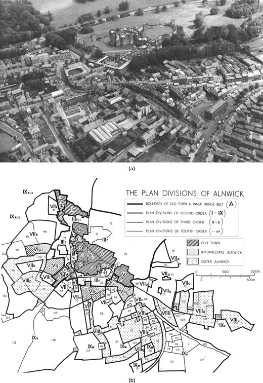
Pattern recognition is a crucial element of the historico-geographical approach to urban morphology. The conceptualisation and methodological procedures for the recognition in the ‘urban landscape’, or ‘townscape’, of areas characterised by unique combinations of patterns, were initially formulated in the ‘Alnwick’ monograph (Conzen, 1960) – Figures 1(a) and 1(b). While the monograph intended to be the first in a series of publications addressing the townscape’s three form complexes, that is town plan, building fabric, and land utilisation, ‘Alnwick’ shows a focus on the town plan – which is reflected in how a pattern is defined two-dimensionally. In Conzen’s systematic classification of urban form (Kropf, 2009), regularities of spatial relationships are to be explored between the three physical complexes, or ‘plan elements’, which constitute the town plan: streets, plots, and buildings. The emphasis on the town plan, which was groundbreaking in the early 1960s, was justified by its ability to structure the other man-made features, providing the physical link between these features, the physical site, and the past existence of the town.
The analysis of Alnwick revealed how streets systems, plots and building arrangements, were combined in different ways in distinct areas of the town. The uniqueness of each combination was based on site circumstances, including topological and historical, and it established a measure of morphological homogeneity. Each distinct combination is a plan unit. The analysis of homogeneity takes place at distinct levels or orders. In Alnwick, plan divisions were grouped into four distinct orders. In the study of Ludlow, developed 15 years later, Conzen moved from plan units to ‘morphological regions’ (Conzen, 1975, 1988), by incorporating the building fabric and land uses in his urban landscape analysis. Again, this is reflected in how a pattern is defined (three-dimensionally). Importantly, in the concept of morphological regions, the three systematic form complexes are related with the degree of form persistence, the morphological periods of the settlement, the morphological constituents of historical stratification, and, finally, with their contribution to the hierarchy of morphological regions. As a result, the physical combination of town plan, building fabric, and land uses occurs in a hierarchical manner within the townscape, whereby the town plan maintains priority, containing and forming the general frame of the land use pattern, and the building fabric within them.
After the Ludlow studies, plan units and morphological regions co-existed at the centre of the historico-geographical approach. One of the reasons for this might be the relevance of town plan. Indeed, for many researchers the elements of the town plan – street systems, plot structures, and building arrangements on the ground – are so important they could be used, alone, to describe, explain, and prescribe the urban landscape. Another reason might be scale. It can be argued that each of these two concepts is better suited for a specific scale of morphological inquiry. Terry Slater sustains that the plan unit is more useful for fine-grain studies of small towns of parts of cities. He argues that the town plan can be seen as a smaller module in the larger morphological region. On the other hand, the region might be more useful for broad-based studies, connected to morphological periods (Slater, 2021). Slater has significantly expanded Conzen’s methodological framework of plan units, providing a detailed method for defining these units in medieval towns (Baker and Slater, 1992).
The development of pattern recognition in the historico-geographical approach throughout the 1990s and 2000s was indirectly framed by Whitehand, through the supervision of two notable PhD theses, by Heather Barrett, in the mid-1990s, and Hiske Bienstman, in the following decade. Barrett (1996) developed important methodological procedures very close to those used by Conzen (1988), paying particular attention to how the different maps of units of each of the form complexes are elaborated and then combined into a composite map. Bienstman (2007) developed a method like that of Conzen and Barrett, proposing a sequence of five main steps for the delimitation of a hierarchy of morphological regions in the townscape. She prepared individual maps of town plan, building fabric, and land utilisation, yielding the production of a composite map with a four-tier hierarchy of regions, for the purpose of townscape management.
The analysis of pattern recognition in the historico-geographical approach reveals the dominance of M.R.G. Conzen’s thoughts until the late 1980s; a few applications in the 1990s, in the British Isles; a major resurgence in the 2000s, including not only Britain, but also the rest of Europe and Asia; and the continuation of a considerable number of applications in the 2010s (Oliveira and Yaygin, 2020; Whitehand, 2009). Whitehand’s review highlighted the different challenges to regionalisation raised by different areas of human settlements, by the comparison of applications in different contexts, and by the application of the concept in planning practice. Oliveira and Yaygin (2020) argued for a stronger linkage between each regionalisation and the historico-geographical approach, for clearer usage of language and terminology in each application to facilitate the shared construction of a more robust method, and for a more explicit and systematic definition of procedural options and steps.
Four recent lines of inquiry can be identified. Firstly, Arat (2023) directly addresses Oliveira and Yaygin’s reflection, proposing a refined method. Each step of the method (resulting in a particular order of regions) is related not only to the tripartite structure of the urban landscape but to explicit criteria. The way how each criterion contributes to the process and how each intermediate map (based on one criteria) contributes to each composite map, representing one order of regions, is carefully discussed by Arat. Secondly, Monteiro and Pinho (2021) explore the integrative capacity of morphological regions to be combined with two fundamental ideas of other morphological approaches – the typological process of basic buildings and the angular segment analysis of street systems. These are brought together in a methodology for morphological analysis and prescription of urban landscapes. The third research line is related to agency, involving the comparison of regions delimitated by different agents such as morphologists and planners, or including residents. The focus on agency was explored not only in Europe but also in China (Whitehand et al., 2011). Finally, over the last years several studies on pattern recognition, conceived outside the historico-geographical approach and usually associated to automation, have come closer to the concepts of morphological region and plan unit. The next subsection addresses the most consistent and systematic of these, urban morphometrics.
3.2 Urban types and morphological regions in Urban MorphoMetrics
In Urban MorphoMetrics (hereinafter: UMM), regularities are observed in the spatial relationships between the recognised constituent elements of urban form. As a specific product of research (Dibble et al., 2017; Fleischmann et al., 2022; Porta et al., 2011), UMM needs to be distinguished from urban morphometrics as a scientific domain of studies. UMM is ‘a method of urban morphology analysis aimed at extracting the inner spatial patterns that distinctively characterise urban places in a numerical form. The method is specifically designed to bring together richness of description with extra-large-scale coverage for the generation of a systematic hierarchical taxonomy of urban form. This is achieved via advanced geo-data processing techniques paired with an analytical architecture that is purposefully designed for scalability’ (Porta et al., 2022). As such, UMM contributes to the wider ‘urban morphometrics’ domain of knowledge.
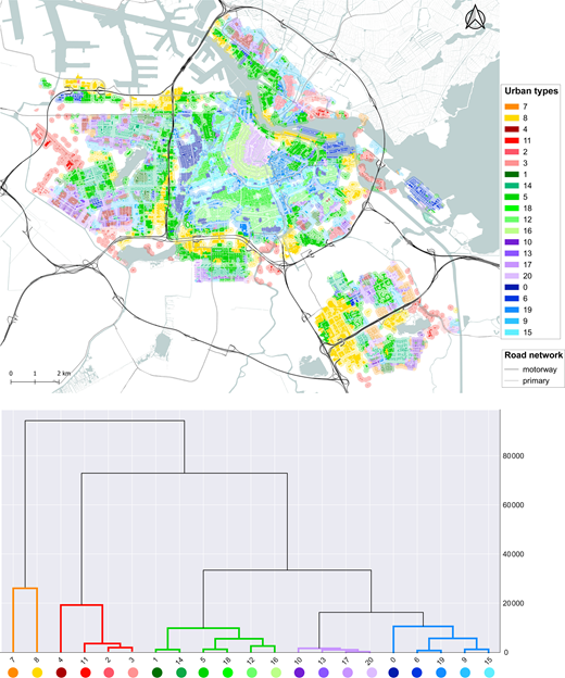
Since its very definition, UMM emphasises an effort towards the systematic analysis of recurrent patterns of urban form. The method minimises the input information, reduced to building footprints (with attributed height) and street network, to increase the method’s scalability to larger extents of coverage. Out of such a parsimonious input information, the system generates 74 primary descriptors divided in six categories: dimension, shape, spatial distribution, intensity, connectivity, and diversity. The unit of information is the individual building/cell, where the cell is a proxy of the plot (Fleischmann et al., 2020), so that each building/cell is described by way of 74 dimensions. The tendency of every primary descriptor within a topological context of each building/cell is then measured with four derived contextual descriptors: interquartile mean, interquartile range, interdecile Theil, and Simpson diversity. As a result, the region is described building by building, where each building/cell is attributed (74 × 4) = 296 dimensions. The buildings/cells are then clustered to identify distinct homogeneous urban tissues, or urban types (UTs), which are colour coded in a numerical taxonomy map (Figure 2, top). Given the numerical nature of the description, it is possible to represent the similarity between UTs along a hierarchically nested structure. This structure can be visualised in a tree-like diagram called ‘dendrogram’ (Figure 2, bottom). Importantly, the map and the dendrogram are structurally linked, so that the number of UTs in the map can be determined flexibly by ‘cutting the dendrogram’ at an upper (smaller number of UTs) or lower (greater number of UTs) level in the hierarchy, without regenerating the analysis.
UMM operationalises urban form characterisation along the line of the historico-geographical approach, with some interesting differences, which are worth unpacking in more detail. First, in UMM the description of urban form is purely numerical, while in Conzen’s tradition the numerical part is less central. The consequences of this fact are several. On one side, the numerical approach makes UMM capable to make use of, and operationally exploit, the current availability of digital information resources both in terms of detailed geo-referenced information and data processing. This, in turn, results in unprecedented scalability, which at the moment reaches the regional and national level (Fleischmann & Arribas-Bel, 2022a; Venerandi et al., 2023). Numerical characterisation also allows a wealth of statistical analysis at both the levels of the descriptors and the UTs: for example, UTs can be profiled in many ways, and the most or indeed the least distinctive descriptors can be identified across the UTs. Most importantly, the similarity between UTs can also be charted in dendrograms, which allows flexibility in the levels of order UTs are represented in the map. On the other side, although UMM is designed to preserve granularity and comprehensiveness of information, there are limitations to the kind and level of morphological data that are currently available in the digital space. This results in UMM and similar morphometric methods featuring a description of urban form that is less biased, but also less nuanced and rich when it comes, for example, to capturing features of the built environment at the streetscape level (Ewing and Handy, 2009) that are relevant in people-environment studies. Again, from a strict UMM perspective, these dynamics occur at a level of the built environment that relates mostly to features such as materials (colour, texture), shape, vegetation, temperature and comfort, legibility and navigability, which despite relating to very relevant experiential human dimensions such as the perceptual, identitarian, and behavioural, do not predominantly liaise with the structure of the urban fabric, hence are not morphological.
4. Conclusions
This is a position paper that investigates the discipline of urban morphology, highlights a theoretical problem that is widely accepted as relevant to the scientific community, repositions the problem in a broader historical and disciplinary perspective, and proposes two relevant conclusions. First, urban morphology has always been quantitative and numerical, to various degrees depending on the approaches, and – most importantly – has always been fully systematic. Secondly, latest developments in the field are an instrument-enabled variation of such systematic disciplinary tradition.
Through the discussion of the main characteristics and fundamental developments of the major schools of thought in urban morphology, from the historico-geographical to morphometrics, the article has made evident that quantification has always been part of urban morphology, and that the dominance of quantitative or qualitative tools has been subject to cycles, shared with other scientific fields. Furthermore, all these schools of thought exhibit a comprehensively systematic nature. This character represents the most consistent contribution of urban morphology to the ‘expanding scope of urban geography’ (Pacione, 2001: p. 31) in the post-WWII period, the ‘quantitative revolution’ (Burton, 1963) that characterised all geography, and indeed all science, culture, and society, in that historical turn. The systematic nature of modern urban morphology is expressed in its consistent focus on cross-regional regularities, the search for universal laws in the patterns of relation among physical elements in space, the construction of theories out of the recognition of such patterns, and finally the recursive validation of theories against real-world evidence.
In that respect, the paper showed that recent developments in urban morphology are part of a consistent disciplinary discourse that emerged in the mid-twentieth century, on the ground of which the different schools should be seen as complementary, by adding different perspectives and layers to the systematic knowledge of urban form. While in some schools the quest for general and abstract laws is more evident, in others it is the search for the whole complexity of each particular and concrete situation that stands in the foreground. And yet, it is in the balance between the general and particular, that the field might be able to find the most effective ways to understand the structural aspects of human settlements’ physical form.
Acknowledgements
The authors are grateful to the editor and the two referees for comments on an earlier version of this paper. The authors are also grateful to Alessandra Feliciotti, Martin Fleischmann, Karima Kourtit, and Alessandro Venerandi for their consent to utilise the image in Figure 2, originally published in Venerandi, A., Feliciotti, A., Fleischmann, M., Kourtit, K., & Porta, S. (2022). Urban form character and Airbnb in Amsterdam (NL): a morphometric approach. Environment and Planning B: Urban Analytics and City Science, 50(2), 386–400.