


– This paper aims to present a new framework for climate change vulnerability, impact and adaptation (VIA) assessment. Greater attention has been given in recent years to the importance of conducting climate change VIA assessment prior to, or as part of, climate change adaptation strategies and projects. A VIA assessment provides decision-makers and project developers with information on the location and causes of vulnerability based on local knowledge and scientific data, so that effective adaptation responses that are targeted and site-specific can be designed. A challenge facing practitioners in this field is the lack of clear methodologies or agreed frameworks on how to conduct a VIA assessment.
– This paper presents a VIA methodological framework that has been developed through three sub-regional pilot assessments on vulnerability and impacts of climate change, as part of the Regional Gateway for Technology Transfer and Action on Climate Change in Latin America and The Caribbean.
– While it is recognized that methodologies and tools may differ depending on the unique local context of the study area and sector under analysis, there are key components that every assessment needs to consider.
– The framework proposed can assist practitioners to deliver outputs from VIAs that are holistic, and provide the most appropriate type of information required for effective, context-specific adaptation responses.
1. Introduction
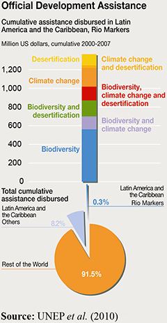
The importance of timely and reliable science-based information on climate change vulnerability and impacts on specific sectors, as a basis for identifying and designing efficient ways for people to adapt to a changing climate, has been acknowledged. However, limited consensus exists as to the best methods for gaining and using this information for decision-making at different scales. The IPCC (2007) definition of climate change vulnerability as a function of exposure, sensitivity and adaptive capacity provides a theoretical framework; however, practitioners differ on the scope and definition of these dimensions. Moreover, guidance on approaches and tools for conducting the assessment of each of these dimensions of vulnerability is limited and insufficiently shared. While context-driven adaptation responses call for unique approaches, a shared methodological framework within which to consider adaptation alternatives can improve quality and efficiency of implementation. A framework integrating the components needed for implementing a climate change vulnerability, impact and adaptation (VIA) assessment can guide practitioners in structuring its design, and selecting most appropriate methods and tools. The relevance of VIAs in the context of funding to address climate change adaptation and mitigation in Latin America and the Caribbean (LAC) countries cannot be underestimated. For instance, between 2000 and 2007, the region received approximately USA$1.4 billion for sectors attempting to deal with climate change, through the Official Development Assistance (ODA) (Figure 1). In addition to ODA, the LAC region has access to other sources of international financing to help developing countries address the challenges of climate change, in terms of both mitigation and adaptation. These include the Clean Technology Fund, the GEF Trust Fund – Climate Change focal area (GEF 4 and 5), the Amazon Fund (Fundo Amazônia) and the Hatoyama Initiative (UNEP et al., 2010).
Many adaptation actions implemented in the context of the aforementioned international aid schemes require an initial assessment of challenges and opportunities to climate change, key impacts and vulnerabilities, so that proposed recommendations and adaptation measures are context-driven, and risks for mal-adaptation measures are minimised. Accordingly, this paper describes a new methodological framework for conducting VIAs, developed through the implementation of three different pilot studies in sub-regions of Latin America, as well as document analysis on 35 VIAs conducted globally (Sabelli, 2011). The research was conducted under the framework of the Regional Gateway for Technology Transfer and Action on Climate Change in Latin America and the Caribbean (REGATTA), implemented by the United Nations Environment Programme (UNEP) and a suite of partners in this region.
2. Vulnerability: Frameworks for assessment
Growing awareness of the complexity of the climate system and the interaction with the human environment has resulted in the emergence of an “integrated” assessment approach, combining the biophysical and socio-economic perspectives to enhance understanding of climate change vulnerability. This shift towards a systems-based approach requires changes in how this type of research is conducted, requiring multidisciplinary, multiscale, multidimensional and participatory approaches (Lu, 2011). Füssel and Klein (2006) provide a comprehensive summary of the key characteristics of a climate change vulnerability assessment, and the implications for climate change policy development; Table I presents three stages of the climate change vulnerability assessment and policy implications identified by these authors.
The stages proposed by Füssel and Klein (2006) are useful to understand why some countries are ahead in responding to climate change adaptation, as it may be prompted by their progression through the various stages of the vulnerability assessment, which, in turn, may be influenced by the country’s political position on climate change, availability of financial and human resources and the presence of research programmes. Biesbroek et al. (2010) postulate that countries that actively participated in the early stages of climate science research tend to be the same ones leading the climate adaptation research nowadays.
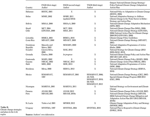
Even when a country has developed a National Adaptation Strategy, it may not necessarily imply that it was derived from information and results from a “third” stage type of climate change VIA assessment. For instance, Biesbroek et al. (2010) analysed nine National Adaptation Strategies in Europe and found they were largely based on national impact studies (first-second stage) and contained very general adaptation measures that related more to how climate change should be dealt with (e.g. the need for more sectoral research) rather than providing specific and feasible options. A similar situation was found for the LAC region, through a rapid assessment on climate change adaptation policy status of 20 LAC countries undertaken as part of the REGATTA project (Table II). The table shows that frequently national plans and strategies are based on information contained in the country’s National Communications Reports, which tend to follow Füssel and Klein’s (2006) VIA and policy development stages. For instance, the information contained in the First National Communications Reports (FNCR) may be characterized as Füssel and Klein’s “Impact Assessment”, the Second National Communications Reports (SNCR) exhibit signs of the second-stage “Vulnerability Assessment” and reports there after fall in between the second and third stages (i.e. Adaptation Policy and Planning/Investment Analysis). Overall, LAC countries appear to be progressing in developing national climate change policies; of the 33 countries, 20 have developed at least one type of national climate change plan. It is difficult to ascertain whether these plans and policies have been informed by local data and knowledge on climate change vulnerability, and very few provide concrete adaptation options. This is supported by that fact that in many cases, the country’s national climate change plan was often prepared following the FNCR and prior to the SNCR (Table II). In fact, for some countries such as Chile, one recommendation under their National Action Plan for Climate Change (2008-2012) was to complete the SNCR.
The majority of the plans and strategies presented in Table II contain adaptation recommendations that are very vague, which is likely due to the fact that these plans were developed using limited “Stage 2 and Stage 3” type of information. To strengthen these plans and move beyond potential adaptation options to more concrete, politically and economically feasible measures, governments need to develop strategies based on VIAs that provide a clear understanding of the causes and areas of vulnerability, including an assessment of the political processes that will facilitate or impede the implementation of adaptation options (Füssel and Klein, 2006; Naess et al., 2011; Preston et al., 2011). Ensuring that VIAs include the type of information and analysis as identified in Stage 3 of the VIA process (Table II) is a complex, costly and time-demanding task; it often requires significant stakeholder participation and access to climatic, social and economic data. These are resources and information that many developing countries lack access to, as it has been highlighted in international deliberations like the Nairobi Work Programme of the UNFCC (Lu, 2011).
3. Methodology
Figure 2 presents the methodological framework developed under UNEP’s REGATTA initiative, which is based on exploratory literature review (Adger et al., 2004; Füssel, 2010; O’Brien et al., 2004; Wolf, 2011); worldwide analysis of 35 climate change vulnerability and impact assessment studies (CAMA, 2008; CATHALAC, 2008; Cutter and Emrich, 2009; Ericksen et al., 2011; IMTA, 2010); and the implementation of three different VIA analyses in the sub-regions of the LAC. The inclusion of an analysis on the “sensitivity of ecosystem services” is one distinctive feature of the proposed VIA framework. This has been incorporated due to the growing interest on ecosystem-based adaptation (EbA), which uses a range of opportunities for sustainable management, conservation and restoration of ecosystems to provide services that enable people to adapt to the impacts of climate change (SCBD, 2009). As such, an analysis of the current state, threats and uses of the main ecosystem services is needed to identify appropriate and feasible EbA options.
The methodological framework is flexible, enabling users to tailor their needs and specific context in which the assessment outputs are to be applied. It identifies the key components to be included in a VIA, including the essential characteristics of a Stage 3 assessment (e.g. adaptation policy assessment and planning), in such a way that outputs generated are relevant for site-specific, feasible adaptation projects and strategies. A variety of tools and methods can be used to assess each component, ranging from the use of highly complex modelling programmes to indicator-based approaches or a basic literature review. Exactly how each component is evaluated and treated is to the discretion of the practitioner, being often driven by the financial, human and technical resources available, data and information gaps, scale and local context. The framework has been divided into three main steps, which may be summarized as setting the stage for the VIA, conducting the assessment and communicating the results. Worth noting is the importance of assembling the VIA team, which should be made up of technical experts from a wide range of backgrounds. The framework and its distinct components provide some insight into the type of multidisciplinary team that is needed: specialists in climate science, ecosystems and biodiversity, socio-economic scientists, experts in stakeholder engagement, policy development and communications. The main modules of the VIA framework are discussed hereafter.
3.1 Stakeholder participation and communication
As one purpose of a VIA is to identify options and to address information needs for adaptation plans and action, on-going participation of relevant stakeholders is essential throughout the VIA process to ensure relevance and use of the final outputs (Holstein, 2010). Glick et al. (2011) report that the more deeply engaged stakeholders are, the more committed they will be to using the results. Preferably, stakeholders should be involved in the initial stages of the project, assisting in the definition of the scope and determining the objectives, right up to discussing and validating the conclusions of the study, in particular, identifying and prioritizing adaptation options. Identification of key actors, their level of involvement in the study, their information needs and how to communicate the results to them effectively are among the first tasks of the project design.
3.2 Scope definition
A clear definition of “vulnerability” must be provided for the context of the study area, as it will have implications for how the study is carried out, and the types of results that are generated. The target audience or end-users need to be identified, along with the geographic or administrative boundaries and the type of information and data available. Some key issues to address in this stage include:
the target of the vulnerability assessment (population, economic sector, ecosystems) and the type of vulnerability to be assessed (e.g. sea-level rise, extreme events);
the objective of the vulnerability assessment;
stakeholders and their information needs;
target users of the adaptation actions, and the purpose of such actions;
geographical or administrative boundaries of the assessment;
identification of significant sectors/economic activities present within the area to be assessed;
identification of ecosystems and services found within and outside the study area that are related to the sector of analysis and well-being of the population, including their significance to the population and/or sector analysed;
time frame of the analysis; and
identification of information gaps; previous studies relevant to the proposed assessment.
3.3 VIA assessment
This step will vary greatly depending on the local situation and institutional capacity of the organization conducting the VIA. Other factors such as the sector, scale, time frame and availability of data and information will determine the method and techniques to be used. The following components should be considered during this phase.
3.3.1 Local climate and climate change scenarios.
Establishing a local climate baseline for the study based on historical trends of temperature and precipitation and identifying current climate risks and impacts is a key step for understanding how future climate change may affect the area. Depending on data, expertise and funding, climate scenarios may be generated using existing global models, and, where possible, downscaled to the local area. It is recommended that scenarios to be used are set within a realistic time frame (2020-2050) to ensure the results are useful and practical for decision-makers and community planners. All climate change scenarios contain some degree of uncertainty, which should be communicated as part of the results.
3.3.2 Sensitivity of the sector(s).
A wide range of approaches can be adopted to assess the sensitivity of a given sector to a changing climate. For instance, the sensitivity of the agricultural sector can be analysed through changes in crop yields and impacts to the export economy, or changes in crop suitability and yield, and implications for food security. If more than one sector is analysed, the inter-relationships between the impacts in the various sectors should be identified.
3.3.3 Sensitivity of the ecosystem services.
This component’s function is to ensure that ecosystem services are adequately addressed, to enable formulating adaptation options based on ecosystem services. Currently, there exists limited guidance and methodologies on how to assess the sensitivity of ecosystem services to climate change. At least the assessment should identify key ecosystems and services relevant to the sector analysed, determine their state, identifying main drivers and threats and how climate change may weaken or strengthen such services. The analysis should also include an evaluation of how the sector’s activities currently impact the provision of the key services needed for its activities. For instance, water provision is a key ecosystem service in the agricultural sector; if the main agricultural activity is negatively affecting this service (e.g. due to the use of non-native species, high water consumption crops and/or high irrigation rates), this aspect needs to be highlighted in the study, and alternative solutions identified. Quantitative and/or qualitative estimation of the value of ecosystem services to the population may be useful for highlighting the economic and social importance of these services to their livelihoods.
3.3.4 Adaptive capacity.
The adaptive capacity inherent in a system represents the set of resources available for adaptation, as well as the ability or capacity of that system to use these resources effectively in the pursuit of adaptation. Such resources may be natural, financial, institutional or human, and might include access to ecosystems, information, expertise and social networks. Adaptive capacity is expressed as actions that lead to adaptation that serve to enhance a system’s coping capacity and increase its coping range, thereby reducing its vulnerability to climate hazards (OEHNSW, 2013).
Identifying indicators that measure social, economic, political, natural and human capital resources is a common approach for analysing the adaptive capacity of the population or system. Careful consideration needs to be given to indicator selection, so that they are relevant to the local context, and provide useful information. Depending on the scale of analysis (e.g. regional, national, sub-national), information may be collected through national statistics, and complemented with data collection through community surveys and/or focus groups.
3.3.5 Vulnerability to climate change.
The integration of information and results gathered from the previous sections (3.3.1-3.3.4) and the identification of the relationships between the various components is one of the most challenging stages of the assessment. Some studies (Gbetibouo et al., 2010; Heltberg and Bonch-Osmolovkiy, 2010; Sullivan and Huntingford, 2009) create an Index of Climate Change Vulnerability assigning a value to each of the exposure, sensitivity and adaptive capacity components and combining them to highlight areas of “high” vulnerability (high exposure, high sensitivity and low adaptive capacity). The creation of an Index of Climate Change Vulnerability has grown in popularity due to calls from international policymakers and financial institutions requesting information that can be used to rank and compare the vulnerability of different countries or locations for apportioning funds and resources. This approach is debated and questioned, as determining who is vulnerable and who is not is highly dependent on data, methods and indicators used in the analysis (Hinkel, 2011; Klein, 2010). Other approaches may include developing an index or spatial map for each component (exposure, sensitivity and adaptive capacity) but analysing them individually as done by CAMA (2008), or producing an integrated narrative of the results (especially common for local qualitative analysis).
3.4 Adaptation planning
The lack of attention placed on adaptation options is a common shortcoming in many vulnerability assessments; in fact, many VIAs present key results and provide a list of general recommendations for adaptation. To be useful in adaptation planning, these assessments need to move beyond the analysis of climate change impacts, and include an assessment of adaptation options, which requires further analysis of the costs and benefits of proposed actions, and the identification of barriers and opportunities that exist for their implementation. A wide range of tools and methods exists for identifying, costing, prioritizing and assessing adaptation options. Some of the key points and methods to consider include:
list the main impacts arising from the VIA, and identify options that address each one;
identify enabling factors and constraints for mainstreaming climate change adaptation into policy and planning;
prioritize adaptation options based on participation of local stakeholders;
estimate (qualitatively or quantitatively) the costs and benefits of the adaptation options;
identify measures that may be considered “no regret” options; no-regret options are adaptation options that make sense regardless of future climate change scenarios, and often produce additional environmental and social benefits;
for EbA options, identify suitable areas for their implementation taking into consideration current and future land uses;
use GIS and other tools for mapping adaptation options, particularly for EbA; and
conduct a participatory scenario planning workshop where the vulnerability results are presented, and future vulnerability is explored under different policy contexts and adaptation options (CARE, 2012; Chaudhury et al., 2012).
4. VIA implementation and preliminary results
This section describes the implementation of the climate change VIA methodological framework (Figure 2) in the Gran Chaco Americano and the Andes region, undertaken as part of UNEP’s REGATTA project. The VIA in the Gran Chaco Americano was carried out by a consortium of three local institutions: Universidad Nacional de Formosa, (Argentina), Universidad de la Cordillera -Fundación la Cordillera (Bolivia) and the Desarrollo, Participación y Ciudadanía (Paraguay) (UNF-UC-FC-DPC); whereas, the International Centre for Tropical Agriculture (CIAT) is conducting the analysis of the Andean region. A brief geographic and contextual description of the study areas is presented hereafter.
4.1 Area and scope of the studies
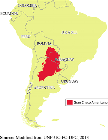
The Gran Chaco Americano is a biome covering 1,000,000 km2 of South America, predominantly in Argentina (56 per cent), Paraguay (23 per cent), Bolivia (13 per cent) and Brazil (5 per cent). It is an area of great biodiversity, and one of the largest intact dry forests in the world. Agriculture is the dominant economic activity, centred on large-scale livestock rising and the cultivation of crops such as soy, wheat, corn, cotton, sugarcane, rice, ground nuts and ground roots (cassava).
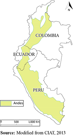
The Andes extends from the north of Venezuela to the south of Chile, covering a range of 7,000 km long and reaching an average height of 4,000 m. Its geographical and altitude range encompass diverse ecosystems, from tropical and subtropical dry broadleaf forest to montane grassland and shrublands. Subsistence agriculture is centred on crops including potatoes and a rich diversity of Andean roots and tubers, coffee, corn, banana, cacao and essential grains such as quinoa, wheat and rice. Livestock grazing tends to be small-scale and limited to sheep, goats, cattle and alpaca.
At the onset of both VIAs, the REGATTA project predefined some of the scoping activities. For instance, the definition of vulnerability as to include exposure, sensitivity and adaptive capacity was required in each VIA. Water and agriculture were the sectors selected for analysis including related ecosystem services. The scoping activities undertaken by the institutions were limited to identifying the key stakeholders in the project, determining the scale of analysis (e.g. departmental, municipal levels) based on data availability and selection of crops to analyse. For the Gran Chaco Americano, the geographic boundaries of the study were limited to Bolivia, Argentina and Paraguay, excluding the small area of the Chaco found in Brazil (Figure 3), while the Andean study area was restricted to Colombia, Ecuador and Peru (Figure 4).
4.2 VIA assessment
The VIA assessment undertaken for both regions intends to determine the effects of climate change on agriculture and water availability, considering the adaptive capacity of the population to cope with these impacts. Based on the VIA results, adaptation options are identified and prioritized through stakeholder participation. An emphasis on EbA options was requested by UNEP, and therefore, the analysis on ecosystem services was included in the assessments. With these objectives, the institutions proceeded to determine the approach and methodology to address each component of the analysis.
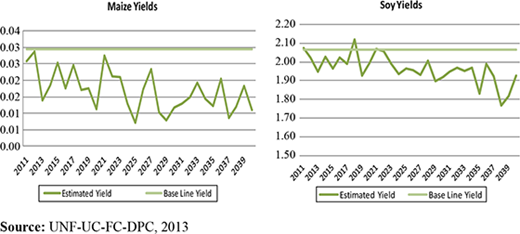
Table III shows that although the VIAs had a common objective, the methods and techniques adopted in each component differed. Such differences are related to data and information availability and accessibility, experience and knowledge in the use of models and other tools and availability of time and human and financial resources. For instance, in the Chaco Americano, the technical team evaluated the sensitivity of the agricultural sector based on estimated changes in crop yield (Figure 5). The method projected future crop yield using results from the climate change scenarios and the exponential segmented regression of the relationship between crop yield, temperature and precipitation and compared the result to current yields. On the other hand, the Andes team selected a method that enabled analysis of changes for crop suitability areas (Figure 6); the analysis used the Ecocrop model developed by the Food and Agriculture Organization (FAO), which contains information on the environmental and phenological requirements of key agricultural crops at a global scale. Model calibration using local data and knowledge of the area is required, as outputs are at macro-scale. Accordingly, the Andes team calibrated the model for the crops included in their study area, incorporating the results from the climate change scenarios to identify land areas that may become more or less suitable for the crops analysed. The decision to use Ecocrop was based on several factors, including the organization’s past experiences on its use, cost (it is less expensive than similar models) and the access and availability of model data input. Contrastingly, the data parameters required by Ecocrop are extensive and most of the data required does not exist in the Gran Chaco Americano; as such, the implementing partners (i.e. UNF-UC-FC-DPC) selected a different approach.
Both teams found the analysis on ecosystem services to be the most challenging VIA component, given the lack of tools and guidance for practitioners on how to evaluate the sensitivity of ecosystem services in the context of climate change. As such, each group adopted a different approach, informed by local knowledge and “trial and error” method. The Gran Chaco Americano team made extensive use of GIS to generate maps of ecoregions, land cover change and ecosystem services combined with stakeholder consultations to identify the threats, status and trends of the ecosystem services under the context of current and future climate conditions. Their analysis comprised two stages:
Produce a map of the 44 ecoregions present in the Gran Chaco Americano and a land use map. Land cover change was calculated using the classification of agricultural and urban areas as proxy indicator of land change; the land cover change map was overlaid with the ecoregion map to identify ecoregions with the greatest land cover change (i.e. loss of original land cover). Climate change resilience was evaluated using the loss of original land cover as a proxy, i.e. the greater the loss of original land cover, the less resilient the ecoregion.
Identify the key ecosystem services in the Gran Chaco Americano and ecosystem functions associated with those services; assign each ecoregion a value associated to the relative magnitude of the ecosystem function existing within that ecoregion (e.g. relative to other ecoregions); and assign each ecosystem function a value based on its relative contribution to those ecosystem services.
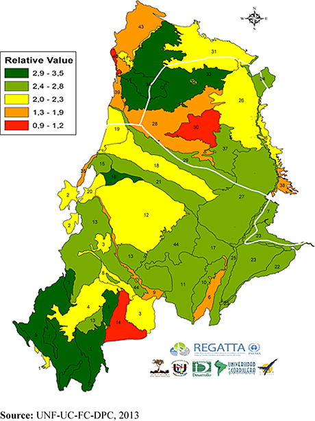
Based on this assessment, maps of ecosystem services related to regulation, support and provision were produced, identifying the ecoregions which contribute the greatest to maintaining these services. These maps could be overlaid with the maps of exposure and extreme events to identify the ecoregions and ecosystem services at risk to climate change (Figure 7). The output maps are also useful for identifying appropriate areas for ecosystem-based adaptation.
The team implementing the VIA Andes adopted a different approach, based on a qualitative analysis of the current status and threats faced by key ecosystems and their services identified in the Andes. Using stakeholder consultations and local knowledge of the area, the impacts of climate change on these services were evaluated qualitatively.
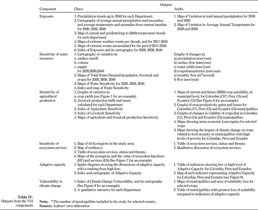
The methods and techniques described in Table III generated the outputs related to exposure, sensitivity, ecosystem services, adaptive capacity and vulnerability, as presented in Table IV.
Table IV shows each component of the analysis generated outputs often in the form of maps, tables and indices. Some of the outputs were used independently of the other components. For instance, in the Andes pilot study, results from the sensitivity of water resources were not incorporated into any of the other components of the analysis and, therefore, in many ways may be seen as a “stand alone” analysis.
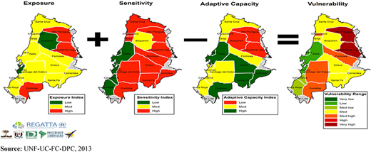
The approaches adopted by each team for the final analysis on Vulnerability to Climate Change are different. The Gran Chaco Americano team created an index and related cartography of Climate Change Vulnerability, using outputs of the Index of Exposure, Index of Sensitivity of Water Resources and Agriculture Production and the Index of Adaptive Capacity (Figure 8). The Andes team used the outputs from the changes in crop suitability (also based on the outputs from the exposure assessment) to identify the municipalities with the greatest potential losses of crop-suitable areas. An example of the information resulting from this analysis is presented in Figure 9 for Municipalities of Ecuador (e.g. The municipality of Pindal is “highly vulnerable” to climate change, as it may lose 78 per cent of current crop-suitable areas). The indicators of adaptive capacity allow for a discussion on the municipalities that are highly vulnerable to changes in crop suitability and their level of adaptive capacity. Individual representation of the indicators enables identifying the strengths and weaknesses in each municipality in terms of adaptive capacity, which can then be used to inform adaptation planning.
4.3 Adaptation planning
An objective of the VIA analysis is to provide information to support adaptation planning processes. Each study devised a preliminary list of adaptation options relevant to their unique geographies and expected climate change impacts. Through a series of workshops conducted in each country, key results were presented to a group of stakeholders (a combination of national and local authorities, local and scientific experts and researchers) to identify and describe adaptation options and prioritize them based on pre-selected criteria such as “the ability to reduce climate change vulnerability, economic feasibility and social acceptability”. Although it has been mentioned that climate change vulnerability and adaptation depends on the local context, some similarities emerged from these workshops; whether in the Gran Chaco Americano or the high Andes mountains, stakeholders seemed to agree on some key actions that may strengthen the resilience of population to climate change, and often identified EbA approaches. Some of these included:
establishment of early warning systems and distribution of climate information;
technical support and capacity training to communities, particularly related to climate change impacts on agriculture and alternative land management practices;
implementation of mixed production systems: agroforestry and silvopastoral systems;
conservation agriculture;
reforestation with native species, forest conservation, establishment of biological corridors;
development and implementation of integrated watershed management plans; and
rainwater harvesting systems.
5. Discussion of results
The results from the Latin America VIA pilot studies and the outcomes of the associated workshops have been successful in generating interest and public participation, particularly among the local and national governments who recognize the usefulness of the information generated. In many cases, these studies are seen as filling an information gap on climate change vulnerability at a local level, and therefore, are achieving their objectives of strengthening the local capacity to cope with, and plan for, climate change. This constitutes a positive advancement for adaptation policies and actions in the LAC region; Turra et al. (2013) conclude that baseline studies (such as VIAs), monitoring and forecast studies alone are insufficient for understanding of detrimental global environmental changes in the LAC region. They advocate that concerted efforts at the science–policy interface are needed as well; such efforts require stakeholder engagement and public participation as the VIA process promotes. The following section discusses challenges and limitations of the methodological framework, as well as the dilemma associated with investments in this kind of assessments.
5.1 Common challenges and limitations with the application of the methodological framework
Throughout the implementation process, the institutions encountered several challenges, and although the pilot projects were conducted in different geographical settings and by different organizations, there are some shared issues discussed hereafter.
5.1.1 Participation.
Stakeholder involvement requires significant time (for the assessor and the stakeholder), financial resources (for workshops, traveling, etc.) and even interest, which are often limited. Each study had a budget set aside for at least two workshops in each country, one to present the study and the other to identify adaptation options. This has shown insufficient to ensure “meaningful” participation. Nonetheless, the implementing institutions have attempted to overcome this shortcoming by presenting the study at various events and opportunities that arouse to engage the local stakeholders, and by holding virtual presentations and discussion. A second issue to consider is that even when the appropriate local and national governments are present at the workshops and they genuinely participate and are interested in the study and the results, uncertainty remains on how to mainstream them into policy and practical implementation.
5.1.2 Data and information.
Availability of, and access to, relevant climate information has been poor in most cases, in addition to being of questionable quality in some instances. Homogeneity in data coverage (e.g. format, completeness, reliability) was another challenge faced given the transnational nature of the vulnerability assessments undertaken.
Scale of analysis, whether it is conducted at the national, departmental or municipal level. As these studies covered several countries, finding data of similar resolution, especially when countries have adopted different administrative units (e.g. districts vs provinces or municipalities) for data collection, was a challenge.
5.1.3 Models.
Often require data that many institutions in developing countries lack access to; furthermore, models such as Ecocrop have been developed at global scale, resulting in coarse outputs that fail to accurately represent local situations. The latter can be overcome by calibrating the model with local data (if they exist), though it requires additional financial resources and time.
5.1.4 Methods for assessing ecosystem services.
There appears to be a lack of guidance and methods available for conducting an assessment on ecosystem services as part of a climate change vulnerability analysis. While some methods and models have been developed to assess the value of ecosystem services (e.g. InVest; TEEB; SolVES), these often fail to help understanding how climate change may affect the provision of these services. The methods used by the institutions in their VIAs (Table III) represent innovative approaches and a significant methodological contribution to the field of vulnerability impact assessment.
5.1.5 Integration of results.
Even when the team is multidisciplinary because of the nature of the VIA assessment being disaggregated into the distinct components, aforementioned specialists tend to work alone on their section (e.g. the hydrologist assessing water resources, the climate specialist working on the climate scenarios) and, as such, the results tend to be compartmentalised and may appear as standalone studies. Integrating key results from each of these components and highlighting their relationship is a challenge that requires an inter-disciplinary approach, including good communication and coordination between each of the specialities to ensure a coherent narrative of the climate change vulnerability of the study area and the adaptation options available.
Similar challenges have been identified by others working in the VIA field in different geographical regions (Hammill et al., 2013). While there is no one clear solution to the challenges abovementioned, sharing implementation experiences and lessons learnt between practitioners in the field, especially south-south communication, is an essential step for overcoming some of these constraints.
5.2 Striking the balance between doing too much and not enough VIA assessment
There are trade-offs between the amount of time and budget spent on assessing climate change vulnerability and impact, identifying adaptation actions and implementing them. Politicians, policymakers and practitioners face hard decisions on a regular basis about how much time and budget to commit to this type of assessments versus implementing concrete actions that can show progress and results over a short time span; this is particularly challenging in developing countries with a limited budget. Many regions are already experiencing climate change impacts and require urgent actions rather than awaiting the completion of a VIA assessment. On the other hand, actions that are designed without sufficient information and analysis may lead to mal-adaptation, which occurs when a measure increases greenhouse gas emissions, has negative implications for the most vulnerable, has high opportunity costs, reduces incentives to adapt, sets paths that limit future choices and is environmentally unsustainable (Barnet and O‘Neil, 2010). As such, a VIA assessment that is as holistic as possible, considers biophysical and social and economic factors of vulnerability and incorporates analysis of adaptation options should reduce the risks of implementing mal-adaptation options. However, such assessment requires significant financial and human resources investment and time.
A conscious trade-off between financial resources spent on a VIA versus their full use in implementation of adaptation actions could be based on criteria such as:
likelihood of using the information gained through the assessment for the formulation of adaptation and/or development plans (at national, local and/or sectoral scales);
availability of financial and human resources; and
availability of, and access to, existing information and expert opinion which can minimize the investment in a VIA (Figure 10).
The time frame for implementing concrete adaptation options is also a driver on the decision about carrying out an assessment (e.g. how quickly the information is needed for use in different planning processes at national, sectoral, municipal, state/provincial, project area). The Latin American case studies described in this paper show that a participatory VIA assessment demands between 12 and 15 months.
Adopting multi-criteria analysis under a protocol guided by a type of If-Then rules could drive the decision on whether significant investment in a VIA is highly advisable, advisable, acceptable or least advisable, as illustrated in Figure 10. A decision on whether a VIA is a necessary step as part of climate change adaptation projects or actions becomes more challenging when human and financial resources are scarce; a higher level of discussion and agreements on the use of the information gained through a VIA is needed to justify investing in the assessment, particularly if there is moderate or high amount of information available or accessible that could be used to determine “no-regret” options.
The UNEP REGATTA experience shows that further research is needed to enhance decision between the level and sophistication of a VIA assessment needed versus what is actually feasible and most useful. With the growing urgency to act, an easy solution may be for practitioners to focus on collecting and analysing existing information and presenting it to decision makers using participatory scenario planning methods and identifying adaptation options that may be considered “no-regret” measures.
6. Conclusions
Climate change vulnerability is a complex, continually evolving concept. Its practical application through VIA assessments requires inter-disciplinary teams that integrate an analysis of climatic, biophysical and social factors into a single coherent scenario of vulnerability, and based on these results, identify and prioritize practical and feasible adaptation options, all while maintaining stakeholder participation; a daunting task for institutions of developing countries with limited access to financial, technical and human capacities.
A 2009 report on low carbon-high growth in LAC (Torre et al., 2009) highlights that better information to reduce uncertainty and help people make well-informed choices is a pre-requisite for adapting efficiently to a changing. The methodological framework presented in this paper intends to provide practitioners and decision makers with a tool to facilitate and manoeuvre through the various components of a climate change vulnerability impact assessment. The framework integrates biophysical and social factors of vulnerability, places an emphasis on ecosystem services and their inclusion as part of adaptation options and stresses the need to move beyond the VIA assessment to an analysis of adaptation options identified to arrive at well-defined practical and feasible measures. The framework proposed is not intended as a detailed recipe, rather as a collection of leading practice. Institutions carrying out a VIA assessment will have to identify specific tools and methods to this end, which will differ as a function of time, resources and information available; yet, the key components of the approach discussed in this paper should remain.
In the face of uncertainty particularly in relation to issues such as climate change adaptation and monitoring, learning and adaptive management become essential, the concept of “learning to manage by managing to learn” becomes an essential part of the VIA assessment process. The VIA framework can be seen as an example of adaptive management, in that it continues to evolve as lessons learnt from its application are fed into the framework to enhance its components.
The Latin America institutions carrying out the VIAs presented in the case studies have played a fundamental role in helping to understand how its application materializes in practice, and although they have not achieved perfection in its application, the challenges identified and methodological solutions developed have been a key learning experience in the project, and the region. Finally, it is evident that the need for climate change adaptation in Latin America, and in other developing regions, is growing in urgency, and while actions should be taken based on VIA results, there is a need to strike the balance between assessment and action.
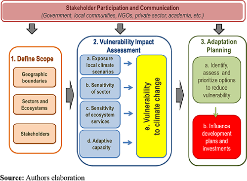
Methodological framework for vulnerability, impact and adaptation assessment
Methodological framework for vulnerability, impact and adaptation assessment
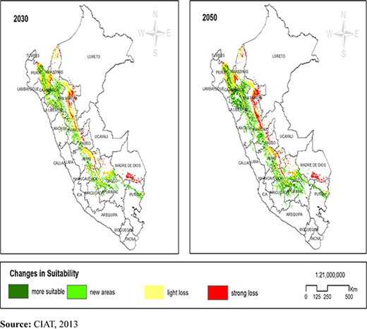
Changes in climatic suitability for corn production in Peru (2030 and 2050)
Changes in climatic suitability for corn production in Peru (2030 and 2050)
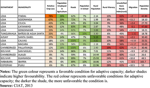
Municipalities most exposed to climate change and adaptive capacity indicators
Municipalities most exposed to climate change and adaptive capacity indicators
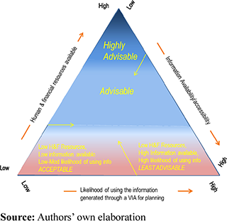
Example of criteria guiding trade-off and decision about a VIA assessment. Qualitative statements can be applied as if-then rules. For example:the likelihood of using the information gained through the VIA for adaptation and/or development plans at national, local and/or sector scales is High,there is a high to moderate availability of human and financial resources,information available/accessible is Low THEN investing in VIA is Highly advisable’
Example of criteria guiding trade-off and decision about a VIA assessment. Qualitative statements can be applied as if-then rules. For example:the likelihood of using the information gained through the VIA for adaptation and/or development plans at national, local and/or sector scales is High,there is a high to moderate availability of human and financial resources,information available/accessible is Low THEN investing in VIA is Highly advisable’
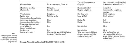
Three stages to climate change vulnerability assessments and policy implications
Three stages to climate change vulnerability assessments and policy implications
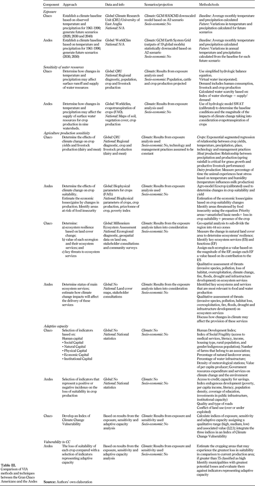
Comparison of VIA methods and techniques between the Gran Chaco Americano and the Andes
Comparison of VIA methods and techniques between the Gran Chaco Americano and the Andes
References
About the authors
Prof Graciela Metternicht is a leading authority on environmental management, with a special interest in geospatial technologies for analysis and monitoring of environmental changes. Her distinguished career has included appointments as Regional Coordinator of Early Warning and Assessment of the United Nations Environment Programme (UNEP) for Latin America and the Caribbean and at the School of Natural and Built Environments of the University of South Australia and the Western Australian School of Mines, Curtin University of Technology. She has published widely in international journals and has attracted significant research funding through Australian competitive grants, international grants and research contracts. Graciela Metternicht is the corresponding author and can be contacted at: g.metternicht@unsw.edu.au
Ms Andrea Sabelli works at UNEP’s Regional Office for Latin America and the Caribbean as a Climate Change Vulnerability Specialist. She has been involved in the development and implementation of the adaptation component the Regional Gateway for Technology Transfer and Climate Change Action (REGATTA) project in Latin America and the Caribbean. Before joining UNEP, Andrea worked in Toronto, Canada, as a Carbon Analyst at an environmental engineering firm in the field of carbon accounting. Andrea holds a master’s degree in geography and environmental studies from the University of Toronto.
Mr Jason Spensley has over 15 years' experience in the fields of climate change adaptation, financing biodiversity conservation and local capacity development. This experience has been gained at the global level, as well as more locally in Latin America and the Caribbean. Jason heads the climate change adaptation unit, within UNEP's Regional Office for Latin America and the Caribbean. Previously, he managed the LifeWeb Initiative, within the Secretariat for the Convention on Biological Diversity. He previously served as Vice Chair of the IUCN World Commission on Protected Areas, as well as Sr. Scientist and Sr. Policy Advisor with The Nature Conservancy.
This research is funded by the Governments of Spain and Norway through the Regional Gateway for Technology Transfer and Action on Climate Change in Latin America and the Caribbean –REGATTA – project administered by UNEP. The authors are grateful to the teams carrying out the VIA analysis presented in this paper, including Instituto Desarrollo, Universidad Nacional de Formosa, the Fundación Cordillera and International Centre for Tropical Agriculture. The contents in the manuscript reflect the opinions of the authors and do not constitute the views of the institutions.

