


– This study aims to assess how small check dams built across rivers in India’s drylands can revitalize rivers during dry season and mitigate local climate change consequences. The surface- and groundwater resources are increasingly under pressure throughout India. The imminent climate change consequences will further aggravate the crisis and this paper has addressed this difficult issue.
– This study was conducted in India’s dryland districts, namely, Dahod in Gujarat and Jhalawar and Banswara in Rajasthan state, to assess the impacts of small dams. Data on dams, sustainability, groundwater levels and benefits to farmers were systematically collected to analyze advantages offered by check dams with reference to climate change mitigation.
– The study shows that 356 check dams built during 1990-2012 across the tribal drylands of India, with a cost of USD 17 million, benefited over one million people from farming communities. The dams also increased groundwater levels in villages, revived rivers during dry season and increased forest growth along rivers, ultimately mitigating local climate change-imposed negative consequences.
– Data on small dams are limited in India, as public have no access to such data because the work is done mainly by local contractors.
– The check dams, the role of which is highlighted here, are simple, eco-friendly and cost-effective. If it is adopted across the vast drylands of India and elsewhere, it has the potential to increase agricultural output; guarantee food security; enhance groundwater resources; and, above all, mitigate local climate change consequences.
– If check dams are built in large numbers across India, it has the potential to increase agricultural output; guarantee food security; enhance groundwater resources; and, above all, mitigate climate change.
– The highlighted results and discussion will guide scientists, politicians and policymakers to make informed decisions to combat India
s future climate change consequences.
1. Introduction
Water has emerged as one of the most important commodities of the twenty-first century. However, the management of freshwater is a shared responsibility involving various stakeholders that include consumers, communities, governments and corporations (United Nations, 2006). The global demand for water over the next 25 years is expected to exceed by 40 per cent with serious ecological, economic and social consequences (Hoekstra, 2013). To make matters worse, desertification has become a crisis posing threats toward sustainable development (D’Odorico et al., 2013). Any further degradation of the ecologically fragile drylands will eventually impact the planet’s natural resources gravely. Experts have warned that 50 million people will be displaced worldwide as a result of desertification during the next decade (Haag, 2007). The drylands cover 41 per cent of the Earth’s total surface area and they sustain 38 per cent of the global human population (Millennium Ecosystems Assessment, 2005). Therefore, the United Nations has adopted the Convention to Combat Desertification in 1992, so that sustainable development initiatives can be promoted to decelerate environmental deterioration. Nevertheless, dryland areas are expanding worldwide due to increase in temperature as a result of climate change consequences (Feng and Fu, 2013).
About 69 per cent of India’s landmass falls under the category of drylands, accounting to 564 million acres out of the total 810 million acres of land area (National Report to UNCCD, 2011). Besides, India has the second largest arable land in the world following the USA. But India’s agriculture is dominated by small farms, where 60 per cent of landholders own 17 per cent of farmlands with an average holding of 2.5 acres. In contrast, 7 per cent of the medium-to-large landholders (>10 acres) own 40 per cent of farmlands (European Commission, 2007; Agoramoorthy, 2012a). Moreover, the small landholders are often subsistence farmers with low investment potential. So they can seldom sustain farming without financial backing from the government. The collapse of the World Trade Organization’s (WTO’s) Development Round Negotiations, held at Doha, in 2006, has shown the reality of this alarming trend (Pritchard, 2009).
The climate change impact models have predicted that India will face extreme weather conditions in the form of consecutive droughts, severe monsoons, serious floods and rapid rise in sea levels (Schellnhuber et al., 2006; Mujumdar, 2013; Shinde and Modak, 2013). Therefore, the sustainable development agenda has become crucial to minimize future climate change impacts. The term “sustainability” generally refers to meeting future demands without compromising the integrity of Earth’s natural environment that includes all delicate and diverse ecosystems (Daly and Cobb, 1989). The large-scale land use patterns across India have contributed to drastic decline in surface- and groundwater resources (Giordano and Villholth, 2007; Agoramoorthy, 2012b; Chinnasamy et al., 2013; Chinnasamy and Agoramoorthy, 2015). Besides, irrigation is the major driver of agricultural productivity, as majority of the workforce (68 per cent) across India relies on farming despite its diminishing contribution to gross domestic product from 38 per cent in 1975 to 13.9 per cent in 2014 (Agoramoorthy, 2012a, 2015). Irrigation is known to increase outputs even in drylands, stabilizing food security with affordable cost (Hanjra and Gichuki, 2008; Hanjra et al., 2009; Agoramoorthy and Hsu, 2013). In fact, a meager 19 per cent of the irrigated land in about 270 million hectares of area has been reported to supply about 40 per cent of the global food productivity, enhancing substantial socioeconomic benefits (Molden et al., 2010). In spite of this, water scarcity can also reduce agriculture production, and therefore, influence food insecurity, both locally and globally (Falkenmark and Molden, 2008; Agoramoorthy, 2008, 2015).
The fundamental problem of unsustainable development lies in the agriculture sector, as it is the largest user of surface and groundwater resources worldwide. For example, water withdrawal for irrigation leads to about 70 per cent of the total anthropogenic use of renewable water resources (2,630 Gm3/year out of 3,815 Gm3/year; Fischer et al., 2007). Sadly, barely half of the withdrawal reaches the crops, while the rest is wasted in leakage associated with poorly maintained canal systems or evaporation (Agoramoorthy, 2012a). Therefore, irrigation water usage is critical to eliminate food insecurity and mitigate climate change consequences. Water scarcity has already become critical in many parts of the world; hence, the concept of water footprint has gained momentum (Hoekstra, 2013). Politicians and policymakers worldwide are facing a tough time tackling the water needs of the burgeoning human population, and future wars could be even fought over the dwindling water supply (Chellaney, 2013).
Since centuries, rivers have been considered sacred in India. The Puranas (ancient Hindu Scriptures) portray that a person can gain salvation by bathing in the Ganges, and the same goal can be achieved by seeing the holy river Narmada. But the survival of many rivers is at stake, due to on-going unsustainable activities (Agoramoorthy, 2012a). By building large dams, humans have drastically changed the nature of river flows. Before 1900, only 40 reservoirs had been built with a storage volume greater than 25 billion gallons (Molden, 2007). Out of the total of about 48,000 dams built worldwide that are taller than 15 m, half of these are found in China (www.unep.org/dams/WCD/report.asp). These dams in total hold over 6,000 km3 of water. Besides, an additional 1,600 large dams are under construction in several countries, with an annual expense of over US$50 billion. The existing dams generate about 20 per cent of the world’s electricity and one-third of the countries rely on hydropower. Half of them were built primarily for irrigation needs to grow food. There are about 230 large rivers worldwide, and 60 per cent of them are fragmented by large dams, diversions and irrigation canals, causing ecological degradation (Postel and Richter, 2003). The dam-displaced population goes up to over 80 million worldwide. The twentieth century alone has spent over US$ two trillion on large dams. The water usage has been tripled worldwide since the 1950s, and, for decades, policymakers have met this rising demand by building bigger dams. The battle over dams is at the center of conflicts involving water scarcity, ecological distress, biodiversity loss and survival of people (Kumar, 2006). India’s Sardar Sarovar Dam became the most contentious dam because of its displacement of people and environmental impact. India, by the way, is one among the most prolific dam builders in the world with about 4,300 large dams, and it also ranks third in holding the highest number of completed large dams, following China and the USA (Ray, 2010).
India cannot entirely depend on large dams for irrigation because it harbors enormous areas of rural drylands (Jagawat, 2005; Agoramoorthy, 2012b). Therefore, rainwater harvesting through small dams, also known as check dams, is fundamental, if the country needs to combat climate change scenarios involving surface and groundwater resources. Besides, not all areas can access water from large dams, so the smaller check dams are indeed vital. This paper presents data on how eco-friendly check dams can transform infertile drylands to productive agricultural lands, revive rivers during dry season, enhance forest growth along rivers, recharge ground water and ultimately mitigate climate change consequences in local perspectives.
2. Materials and methods
2.1 Study region
The present study was carried out in three districts of India, namely, Dahod (22.8339° N, 74.2578° E) in Gujarat and Jhalawar (24.6000° N, 76.1500° E) and Banswara (27.2000° N, 74.0000° E) in Rajasthan, where most of the check dams were constructed during 2001-2006. The Dahod district (area 3,642 km2) harbors 1,636,433 people, with 72 per cent of them belonging to tribal communities (also known as adivasi, meaning “aboriginal people”). The average maximum temperature goes up to 46°C, while the minimum goes down to 8°C, with a mean annual temperature of 26°C (Government of India, 2011). The district receives 860 mm of annual average rainfall. The Jhalawar district (area 6,928 km2) is not only the poorest but also the least developed in Rajasthan. It supports 1,180,342 people and 86 per cent of them live in rural areas. The district harbors 1,585 villages and 40 per cent of the total land area has irrigation water. The region receives an average annual rainfall of 95 to 1,000 mm. The Banswara district has an area of 5,037 km2 (1.47 per cent of Rajasthan state), and it is one of the least developed in Rajasthan (Government of India, 2011).
2.2 Data collection and analysis
Surveys were conducted using topographic maps and satellite imageries to assess the water harvesting potential in selected sites before finalizing the dam construction sites. The Sadguru Foundation, which is a non-government organization (NGO) based in Dahod (Gujarat, India), has been involved in water resource management work since 1974 to provide livelihood opportunities to farmers (Jagawat, 2005). Using field maps and satellite imageries, patterns of forest types and drainage networks of rivers were identified. Field survey methods, instruments for the design, preparation of drawings and check dam estimates follow the standard civil engineering methods (Bondelid et al., 1982; Mays, 2010). Data on variables such as need for check dams, sustainability, community benefits, farmers’ migration pattern, educational background, family structure and employment opportunities were collected while visiting check dams located in Gujarat and Rajasthan (McNeely and Scherr, 2001). The water storage capacity of check dams was calculated using the formula: length of water spread area × width × effective height = volume of water stored in check dams (Bondelid et al., 1982; Design of Small Dams, 1987). Satellite imageries showing before and after the construction of check dams in rivers during 1990-2007 were obtained from the National Remote Sensing Agency.
Data on rivers, dam measurement, storage of water in dams, water recharging in village wells, employment of local people in construction work and dams’ impact on community and ecology were pooled from the archives of the Sadguru Foundation. Discussions with villagers (n = 300) were conducted while visiting check dams and irrigation corporative operated by communities to record details on the ecological and livelihood benefits (McNeely and Scherr, 2001). Groundwater levels in village wells were monitored by using a graduated steel tape (Lapham et al., 1997).
A total of 356 check dams were constructed between 1990 and 2012. Statistical analyses were conducted using the Statistical Analysis System software (SAS Institute, 2000). All mean values are presented as ±1 standard deviation. A linear regression analysis was used to estimate the cost (US$) according to the length of the check dams. Various general linear models were used to test the effects of variables such as the total length, crest and height of dams, water storage capacity, irrigated area, command area and cost of check dams. A general linear regression analysis was used to estimate the cost, while ANOVA was used to test factors that influenced the capacity of check dams. The Indian rupee was converted to US$ according to yearly exchange rate offered by the Government of India.
3. Results
3.1 The eco-friendly check dam model
Check dams are made of small barriers using stones, steel, cement and concrete; they can be built across the direction of water flow on rivers (Agoramoorthy, 2012b). They retain excess flow during monsoon in small catchment areas. The major benefit of such check dams is the replenishment of nearby groundwater reserves and wells. The surface and sub-surface water entrapped by the check dam is intended for irrigation later in the dry season. It can be also used for livestock and other domestic purposes.
The Grand Anicut (“Kallanai” in Tamil language) is considered to be India’s oldest check dam, which still works. It was built by the Chola dynasty King named Karikalan in the Cauvery River of Tamil Nadu, in the south of India during the second century AD. During the British occupation (1757-1947), two military engineers had pioneered large-scale irrigation – Proby Cautley, who built the Ganges Canal, and Arthur Cotton, who rebuilt the Grand Anicut on the Cauvery. Both the systems supplied water through hundreds of miles of a long canal system to boost agriculture. When the British East India Company took the management of Cauvery delta in 1799, it was unable to check the rising river due to the silt backed up against the dam. The engineers struggled for 25 years and finally by adopting an indigenous technology, Arthur Cotton solved the problem while renovating it. He later wrote:
[…] it was from them (Indians) we learnt how to secure a foundation in loose sand of unmeasured depth. The Madras river irrigations executed by our engineers have been from the first the greatest financial success of any engineering works in the world, solely because we learnt from them (Cotton, 1874).
To honor the Chola king and the British engineer, people had erected statues near the Grand Anicut that can be seen today.
The basic rule of check dam construction involves few steps. The dam site must possess minimal degraded catchments with maximum rock formation and with less sediment load in river. The length of the barrier should be small and should open out upstream. The bed gradient of the main drainage channel must be straight to store maximum water, and the created reservoir must not submerge adjoining farms and property. The downstream geology must catalyze recharging of aquifers, recycling of water in wells and enhancing geology (Agoramoorthy, 2008, 2012b). The building of dams must start at the source of the river and proceed downward to form a series. Then, they will form a cascade of reservoirs, large enough to distribute water to villages that never see water during the dry season.
3.2 Cost, conservation and community benefits
By strictly following the principles of the Grant Anicut model, the Sadguru Foundation constructed 356 check dams between 1990 and 2012 across the drylands of Gujarat and Rajasthan in India. These areas are classified as drought-prone, semi-arid and inhabited by indigenous tribal communities that are poor and struggle for survival (Jagawat, 2005; Phansalkar and Verma, 2005).
About US$17 million was used to construct check dams, which increased about 55,000 acres of irrigated area. From 1990 till 2012, an average of about 16 dams per year was completed (n = 30). The total water storage capacity was about 2,000 million cubic feet (mcft). The average cost for building check dams per year was about US$56,000 (n = 23). The area irrigated after the construction of check dams was highest in 2006 (Figure 1). The highest amount of irrigated area increase was about 9,800 acres in 2006 from 18 check dams completed, with a total water storage capacity of about 500 mcft (Figure 1). Besides, about 24,000 people have benefited by the construction of check dams in 2006 alone (Figure 2).
The average height of check dams was 2.8 ± 0.8 m (range 0.8-7.3 m) and the average length was 62.3 ± 44.1 m (range 12-367 m). The average capacity of dams to hold water was 5.7 ± 22.1 mcft (range 0.1-350 mcft). The average number of beneficiaries included 47 households (range 2-3,000). These families used to grow one rain-fed crop annually and faced frequent droughts that forced them out in search for jobs elsewhere. After the check dams were constructed, farmers stopped migrating to towns and cities in search of work. At the time of dam construction, farmers were hired and the employment included 2,152 males and 2,215 females with no gender bias.
The average irrigation area expansion after the construction of check dams was 155 acres (range 3-7,000 acres). The length, height, water storage capacity, irrigated area and command area had significant effects on the cost of check dam construction (F 5, 323 = 92.3, R2 = 0.59, p < 0.001). Among them, the length of check dam was the major factor influencing the cost of construction (F 1, 323 = 46.7, p < 0.001). The longer the length of the dam was, the costlier it was for construction due to materials and manpower usage. The capacity of total water stored after completion of dams was the highest during 2006 followed by 2002 and 2005 (Figure 1). Without check dams, water would have gone straight to the sea, dispersed in surface area or evaporated. The height, command area, irrigated area and cost had significant effects on the capacity of check dams (F 4, 324 = 349.58, p < 0.001, R2 = 0.81). But, the dam cost per meter was lowest during 1990 and 1993 (Figure 3). Likewise, the cost of benefited irrigation area per acre was lowest in 1992 (113 USD/acre) and 1990 (140 USD/acre) and highest in 2011 (853 US$/acre) and 2013 (805 USD/acre). It clearly shows that various government agencies started to offer funds after seeing the benefits provided by check dams to local community and ecology.
It was not easy for the rural NGO to construct check dams. Engineers had difficulty to get clearance, as government officials were skeptical that structures would not withstand floods. Nonetheless, all check dams constructed by the Sadguru Foundation are still intact and managed by community cooperatives, as people depend on them for their livelihoods. India’s government-built big dams are well-maintained. But, check dams constructed by government agencies often fail due to lack of monitoring, community support and flawed site selection. A total of 60 such small dams were seen during a weeklong field trip in Gujarat and Rajasthan in January 2013. The exact number and the cost of construction for such failed check dams implemented by government agencies are not known, as data are not available in public domain.
The check dam construction process is demand-driven and done only on the justification from communities to enhance local agriculture and ecology. Villagers were involved from the beginning, and the management of dams was transferred to community user groups with all charges paid by them for the services obtained. This participatory demand-driven approach ensured that farmers obtained the level of services they desired; they also could afford to pay for such services. Unfortunately, government agencies while building check dams seldom follow this community centered approach, which ultimately leads to malfunction.
3.3 Check dams and climate change
After building check dams in rivers, water conservation was possible in drylands, which eventually increased agricultural productivity, ultimately leading to eradication of poverty, local food insecurity, restoration of natural resources in terms of groundwater recharging and growth of forest vegetation supporting flora and fauna. Due to higher capacity of stored rainwater in check dams, benefited irrigation area also showed similar upward growth (Figure 1).
The check dams did not have any significant negative impact on the environment, indicating their role as an eco-friendly irrigation structure that deserves support from government and corporate sectors involved in rural development. Furthermore, all check dams constructed by the Sadguru Foundation have a gated system that did not restrict the movement of aquatic organisms including fish population. Only the last monsoon flow was stopped by closing the gates to harvest rainwater for use during the dry season. The check dams also revived groundwater resources, especially wells in villages that people often use for drinking, cooking and washing utensils/clothes. In Rozam village (Gujarat), for instance, 10 check dams have increased the groundwater level from <1 to >10 m in about 60 open wells. The high volume of water in check dams benefited irrigation while showing similar upward growth with no negative impact on ecology (Plate 1).
Machhan is a large river that runs across western India, and it has been shown in satellite imagery before and after the construction of check dams with and without water during the dry season (Plate 2). The satellite photos show more water storage and thick vegetation cover induced by the stored water (red/blue shades) after the check dams were built (Plate 2).
The satellite photos provide an example of positive evidence on the scientific significance of small dams in effectively storing water and reviving rivers during the dry season. The stored water from check dams also promotes the growth of forest cover along river banks and beyond, eventually mitigating the negative impacts of local climate change (Plate 2). The expanded forest, in turn, supports more fauna and flora.
Water is fast depleting in India’s semi-arid regions (Chinnasamy et al. 2013). But, check dams have the potential to enhance natural resources, especially recharging groundwater, increasing forest vegetation growth and storing water during the dry season. The eco-services provided by check dams have made all neighboring villages water surplus and those villages were once water deficit (Plate 1). Villagers who have never seen rivers full of water during the dry season held celebrations near check dams in their villages. In addition to people, numerous livestock were able to utilize the water during the hot summer months. Thus, water harvesting measures, especially check dams, are a rational approach for sustaining nature in semi-arid regions while mitigating local climate change impacts involving desertification.
Check dams have been reported to reduce high levels of fluoride (beyond 1.5 ppm) in groundwater, therefore reducing health risks, as fluoride poisoning is common in dryland areas (Bhagavan and Raghu, 2005). Besides, check dams constructed near the forest provide water to a large number of wildlife, especially large mammals such as elephants, gaur, tiger, leopard, antelope, deer and monkeys.
4. Discussion
India’s rivers carry about 400 cubic miles of water annually and the Ganges alone carries 30 per cent of it, benefiting over 400 million farmers (Agoramoorthy, 2012a). But the future survival of rivers is at stake due to rapid development. For example, the large dams built upriver in Karnataka had stopped the flow, especially that of the river Cauvery at its tail end in Tamil Nadu. Supporters believe that large dams deliver water and generate power. However, anti-dam activists argue that they displace millions, devastate floodplains and diminish fisheries that communities depend on for survival. In fact, India had spent over US$25 billion on various irrigation projects from 1990 to 2004. But sadly, the irrigation area has declined from 43 million acres to 35 million acres. Although the canal irrigation supported by large dams had increased during 1991-1992 (44 million acres), it started to decline fast and reached the lowest (35 million acres) by 2000-2001. Similarly, the World Commission on Dams (2001) reported that many irrigation structures connected to large dams have not been maintained. The Planning Commission of India (2002) has stated that the water use efficiency of large dam canal irrigation system was low (30-40 per cent, against an ideal value of 60 per cent) due to water leakage and poor maintenance. Besides, large dams account for about 40 per cent of India’s irrigated area, but the estimates of agricultural production attributing to dams vary widely from 10 to 50 per cent. This certainly shows that relying on large dams can no longer boost irrigation water in rural areas; hence, check dams may provide better prospects to promote sustainable agriculture, mitigating local climate change consequences.
India’s large dams are properly designed, built and maintained by the government. But, numerous minor irrigation structures constructed by government agencies through private contractors have failed due to lack of monitoring, community involvement and flawed construction (Choudhry and Jagawat, 2002). Nonetheless, the check dam model highlighted in this paper is well maintained with community support. For example, the Chief Minister of Rajasthan, a firm supporter of small dams, inaugurated a large check dam at Baneshwardham (length 367 m) with a cost of over US$ one million in 2007. The dam can store of about 350 million cubic feet of water, with a potential to irrigate 7,000 acres and benefit 18,000 people. It is considered to be India’s largest check dam, which is located on the Mahi River. It was constructed by Sadguru Foundation with the financial support of the government. There is another government-built large dam, the Mahi-Bajaj Sagar located upstream with a price tag of about US$300 million. This dam irrigates 154,000 acres, which is 22 times larger than the irrigation area of the Baneshwardham check dam. If 22 more check dams are to be built on the same river in a series, it would cost about US$24 million, with the same irrigation potential. So, we emphasize that if numerous check dams are built upstream and downstream of rivers, they will have similar irrigation potential as do large dams. But, check dams may cost less with less negative impacts. Moreover, the benefits of large dams are restricted to areas around the canal system, while check dams can be built across any rivers covering vast areas. This would benefit a large number of farmers who inhabit remote drylands along river beds.
Groundwater, which is crucial for agriculture, has been dwindling across India in recent decades (Chinnasamy and Agoramoorthy, 2015). The cultivable land remains static at 120 million hectares, relying mainly on monsoon water. India’s green revolution has gone brown due to the creation of agrarian crisis, environmental disasters, stagnating yields and water scarcity (Atkins and Bowler, 2001; Agoramoorthy, 2008). Besides, a farmer commits suicide every 30 minutes, and the continuation of suicide by farmers can be linked to the shortcomings of globalization agenda and negligence of poverty at local levels (Shiva and Bedi, 2002; Agoramoorthy and Hsu, 2008).
The downside of India’s sustainable agriculture strategy is the historical neglect of catchment areas in drylands inhabited by tribal communities for centuries. About 1,500-km-long and 500-km-wide large area, stretching across central India, provides better prospects for future agriculture development (Jagawat, 2005). India’s tribal communities inhabit the aforesaid dry landscape intertwined by river beds. Most of India’s 70 million tribal people are impoverished; they constantly face survival challenges. The foremost among them are the marginal conditions for agriculture influenced by unreliable water supply (Phansalkar and Verma, 2005). Focus has to be on drylands of these areas if India needs to succeed in agriculture sustainability, without creating negative consequences to nature (UNISDR, 2013). Also, the World Bank has already warned India that it is on the brink of severe water shortage crisis (Briscoe, 2005). The agricultural sector that largely depends on water is more vulnerable for serious climate change impacts. Studies have predicted that India may experience warmer and wetter weather due to climate change impacts and the summer monsoon may become more severe in future (Shukla et al., 2003). Moreover, the climate change scenarios will certainly alter the water cycles and consequently impact the quantity and quality of water, both locally and globally (Gleick, 1989).
5. Conclusion
Climate change has become an important economic, social and political concern, as it will directly or indirectly impact the livelihoods of over 700 million people who inhabit rural India. Therefore, all development projects must integrate strategies to mitigate climate change consequences. For example, the water resources management approach outlined in this paper has enormous potential to protect the integrity and functioning of river basins and aquifers. This is vital, as rivers are crucial for the continuation of human survival. It is, therefore, essential for the government to build check dams across rivers to complement large dams in partnership with private corporations and NGOs. Therefore, check dams, the role of which is highlighted in this paper, are straightforward, eco-friendly and cost-effective. If it is adopted across India’s drylands and elsewhere, it has great potential to increase agricultural output; guarantee local food security; enhance groundwater; and, above all, mitigate dangers posed by the looming climate change crisis.
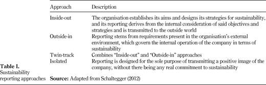
Expansion of irrigated area (log scale) and water storage capacity of 356 check dams constructed from 1990 till 2012 in Gujarat and Rajasthan states of western India
Expansion of irrigated area (log scale) and water storage capacity of 356 check dams constructed from 1990 till 2012 in Gujarat and Rajasthan states of western India
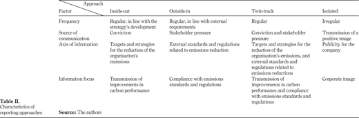
The cost to complete construction of check dams and the number of people benefited each year from 356 dams built between 1990 and 2012 in Gujarat and Rajasthan states of western India
The cost to complete construction of check dams and the number of people benefited each year from 356 dams built between 1990 and 2012 in Gujarat and Rajasthan states of western India
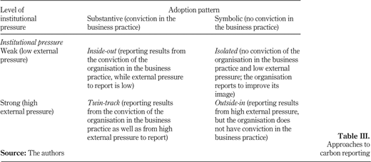
The construction cost of check dams (US$ per meter or per acre) between 1990 and 2012 carried out in Gujarat and Rajasthan states of western India
The construction cost of check dams (US$ per meter or per acre) between 1990 and 2012 carried out in Gujarat and Rajasthan states of western India

A view of the dried-out river Chambal near Sindhla village in Rajasthan state during January 2002 before check dam construction (above) – a view of the same spot during November 2003 after building check dam where backwater go for miles (below) showing the enormous potential of small dams (Photos taken by authors)
A view of the dried-out river Chambal near Sindhla village in Rajasthan state during January 2002 before check dam construction (above) – a view of the same spot during November 2003 after building check dam where backwater go for miles (below) showing the enormous potential of small dams (Photos taken by authors)
References
About the authors
Govindasamy Agoramoorthy is a distinguished Research Professor at the College of Environmental & Health Science, Tajen University, Taiwan. His research ranges from environmental conservation to sustainable development, and he has carried out field research in Asia, Africa and South America over the past three decades. He is the Consulting Editor for the Journal of Environmental Biology (Triveni) and serves in the editorial board of Journal for Nature Conservation (Elsevier). Between 1989 and 1993, he served as the Visiting Scientist at Smithsonian Institution and conducted field research in South America. He is currently Tata Visiting Chair in India and reviews natural resource management projects. Professor Agoramoorthy is an internationally renowned environmentalist. He has authored 25 books, 80 book chapters and 250 scientific articles in international peer-reviewed journals with impact factor.
Minna J. Hsu received PhD in 1992 from the Ohio State University, USA. She is currently Professor and Chair of the Department of Biological Sciences at the National Sun Yat-sen University (Kaohsiung, Taiwan). She has conducted field research on ecology and biodiversity conservation in various countries such as India, Liberia, Argentina, Venezuela, Trinidad, Singapore, Malaysia and Taiwan. Professor Hsu serves in the board of several advocacy groups for nature conservation. Minna J. Hsu is the corresponding author and can be contacted at: hsumin@mail.nsysu.edu.tw
The authors thank Shri Harnath Jagawat and Smt Sharmishta Jagawat for their warm hospitality and kind support. The contributions of Sunita Chaudhary for sharing her experience on check dams are greatly appreciated. The financial support of Sir Dorabji Tata Trust (Mumbai) to carry out research at the Sadguru Foundation through Tata Visiting Chair status awarded to G. Agoramoorthy is acknowledged with gratitude.

