Cockcrow Bridge will be the UK’s first green bridge to support heathland habitats, reconnecting two internationally valuable heathland areas. At 68 m long and 30 m wide, spanning the A3 in southeast England, it will be an exceptional example of green infrastructure. There are hundreds of green bridges in Europe, but currently only ten in the UK. Green bridges have the potential to be a key part of the solution for our nature crisis, providing safe crossing points for wildlife, joining up disconnected habitats and vulnerable populations. Cockcrow Bridge is being delivered as part of a Nationally Significant Infrastructure Project; however, funding was secured separately based on the multitude of benefits the bridge delivers for nature and people. The design of the green bridge is inspired by the nature surrounding it. Typically, green bridges in the UK are planted with hedgerows/trees but Cockcrow will connect two areas of historic common land and provide a corridor of one of the rarest habitat types in the UK – lowland heathland. The article focuses on the design journey – how a required ‘grey’ access bridge for non-motorised users/occasional vehicle access was adapted so that it could deliver a multi-functional ecological corridor.
1. Introduction
The M25 junction 10/A3 Wisley interchange scheme (henceforth referred to as ‘the scheme’ is one of National Highways’ key investments for the London and southeast region. Improvements to the junction were needed due to a poor safety record and daily heavy congestion. Balfour Beatty AtkinsRéalis are delivering the construction and design of the project on behalf of National Highways. Construction commenced in autumn 2022 and is due to be completed in summer 2025.
Fundamental to the scheme design was the need to provide alternative safe accesses for a number of properties off the A3 and a dedicated route for pedestrians, cyclists and equestrians (non-motorised users (NMUs)) to cross freely between all four quadrants of the junction using new overbridges.
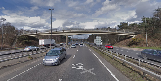
One such bridge, Cockcrow, provided an opportunity for the project to deliver something incredibly special. The existing footbridge was a two-span bridge with a single support in the central reservation, located approximately 400 m south of the junction, which connected Wisley Common (to the west) to Ockham Common (to the east) by a designated public right of way. The design required a new overbridge for occasional vehicle access to be provided close to the location of the existing Cockcrow Bridge to replace the existing direct accesses from the A3 northbound off-slip at junction 10. The structure also needed to support a dedicated bridleway, cycleway and public footpath. Modifications to the existing footbridge (Figure 1) were not an option due to its north abutment clashing with the scheme’s widened carriageway. A new structure was needed and the opportunity for a green bridge arose.
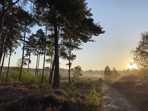
The sensitivities of the surrounding area influenced the next steps in the design process. Ockham Common and Wisley Common are both areas of registered historic common land, which at one time would have supported local graziers (‘the commoners’) regularly moving their animals across a single lane A3. These commons are also particularly key areas for nature and they support some of our rarest habitat – lowland heath. Surrey is a stronghold for lowland heath in the UK, but Surrey has lost over 85% of its lowland heath in the last 200 years (SWT, 2024). Much now exists in small, isolated patches and valuable work is being done to conserve these areas and try to reconnect them due to the value they hold for wildlife, and their historic and cultural interest (Surrey Hills, 2024).
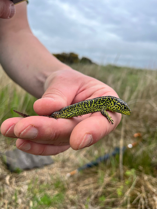
Reconnecting areas of lowland heath is important to make the landscape (and specialised wildlife) more resilient to climate change (explained in Section 2). Ockham and Wisley Commons support nightjar and Dartford warbler – rare birds that rely on the heathland to breed. Within these commons, the sand lizard (Figure 2), an extremely rare and enigmatic species, can currently only be found in Ockham Common to the east (because of a successful reintroduction in the early 1990s) and relies heavily on managed heathland.
As a result of the special habitat and species that Ockham and Wisley Commons support, they are designated as part of the Thames Basin Heaths Special Protection Area (SPA) and Sites of Special Scientific Interest (SSSI) and Local Nature Reserves (LNR). They are managed by Natural England and looked after by Surrey Wildlife Trust (SWT) on behalf of Surrey County Council (SCC), who owns the commons. In addition to the rare heathland species, the commons support other species including grass snakes, adders, badgers, a number of bat species and a healthy population of common toads looked after by a resolute team of volunteer toad patrollers every breeding season when they return to the local ponds.
The range of wildlife to see and the naturally undulating picturesque landscape of the commons also make it a special place to visit, popular for walkers and horse riders. However, the original Cockcrow pedestrian bridge, which has linked Ockham Common to Wisley Common since the 1980s, was an unappealing route for users, especially equestrians crossing over seven lanes of busy traffic – and it provided no connectivity for wildlife.
2. Developing the idea
AtkinsRéalis, National Highways’ appointed designers, conducted a feasibility study in January 2019 that drew on industry expertise, published guidance (Landscape Institute, 2016) and case studies of green bridges within the UK (Natural England, 2015) and Europe. Of the ten UK green bridges that were reviewed for the feasibility study, including Mile End (CZWG, 2024), A21 Lamberhurst (PTES, 2012), A556 Knutsford to Bowden (HMG, 2024), Weymouth relief road (four green bridges in total (DLNP, 2020)) and Aberdeen western periphery road (three green bridges in total) (Transport Scotland, 2024), none were designed to recreate or connect heathland habitats. However, other nature-orientated designs such as the Hindhead tunnel have delivered heathland restoration in Surrey (Arnold, 2012). The feasibility study also reviewed proposed green bridges currently in design, such as the 16 green bridges associated with HS2 phase 1 (HS2, 2024).
The outcome of the study was that there are numerous benefits for nature and people associated with green bridges (as clearly demonstrated by Hewlett et al. (2024)), and that those benefits could also be realised by delivering a green bridge at Cockcrow.
The feasibility study also considered width options, and concluded that a 30 m wide bridge provided the optimum solution for the target species (further details are provided in Section 5) and access requirements. Consideration was also given to separating the occasional vehicle access/NMU route from the wildlife corridor; however, the driver for Cockcrow was people as well as nature, and providing immersion in a natural landscape was key to this. Separating the two elements of the bridge would not deliver this benefit and may (in this instance) have been less likely to achieve necessary funding. European examples of green bridges, particularly from the Netherlands, provided the best examples of where green bridges have been designed for people and nature collectively, and where ‘dry habitats’ like lowland heathland had been successfully created on green bridges. These green bridges influenced the final design (Wegenwiki, 2024; Wikipedia, 2024).
Despite the obvious benefits from providing a green bridge across the A3 at Cockcrow, the green bridge was not part of the necessary environmental mitigation for the M25 junction 10 scheme and it was important that it did not result in further loss of land from the adjacent SPA/SSSI/LNR. Although substantial design work was conducted to reduce this, the loss of SPA/SSSI/LNR is a significant residual impact of the scheme. To compensate for the impacts on the SPA/SSSI/LNR, an environmental compensation package was designed in collaboration with stakeholders; this includes extensive habitat creation and enhancement, and the restoration of 20 ha of lowland heathland within Ockham Common and Wisley Common themselves, adjacent to existing areas of heathland that are already managed for wildlife. However, it was evident that the need for a new bridge across the A3 provided an exceptional opportunity to deliver a larger area of restored lowland heathland by connecting the new and existing heathland areas to each other by a green bridge carefully designed to replicate the natural heathland either side of it.
It was also felt that the bridge could, to a degree, re-address the barrier to wildlife movement created when the A3 was upgraded to a dual carriageway in the 1970s and widened further by the addition of the junction 10 slip roads when the M25 was constructed in the 1980s. There was also a strong desire for the green bridge from a number of organisations (including SWT) who are currently based in Wisley Common and whose access the new bridge would provide.
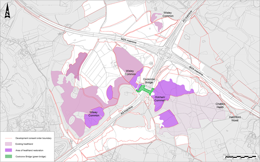
It was calculated that a heathland connection at Cockcrow, in conjunction with the scheme’s existing compensation package, could create a corridor of lowland heathland approximately 3 km long (Figure 3), which would achieve connectivity at a landscape scale for specialist heathland wildlife. The benefits for nature that could be realised by this connectivity are numerous, including (a) reducing mortality of wildlife from road traffic collisions, (b) enabling species expansion, which leads to increased breeding opportunities and (c) vital genetic mixing of isolated populations (which in turn reduces risk of extinction from disease and inbreeding). Heathland is also particularly vulnerable to fire outbreaks. This is especially the case in Surrey, which is experiencing warmer and drier summers due to climate change, thus increasing the risk of fire outbreaks and the severity of such outbreaks. Large expanses of habitat can be lost in such events and fire outbreaks in small unconnected ‘patches’ are far more likely to lead to the extinction of wildlife populations that have nowhere to retreat. A risk assessment of the likelihood and impact of fire outbreak was carried out for Cockcrow (as recommended by Collings (2024)) and this influenced the landscaping layout, which needed to ensure fire breaks in vegetation could be incorporated and maintained.
The benefits of a green bridge at Cockcrow were also found to be numerous for people. Creating a better connected, attractive space with improved amenity and safety for all users of the bridge will encourage active travel in this area (with the new segregated cycleway, footpath and bridleway being delivered by the scheme). Also, connecting the historical adjoining open landscape in an immersive way will provide users with an experience of the commons that has not been possible for many years and will be unique to this part of Surrey (further details are provided in Section 5) (Figure 4).
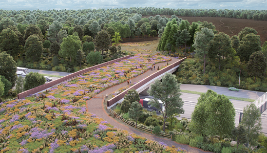
Visualisation of Cockcrow green bridge – viewpoint from Wisley Common (west) (©AtkinsRéalis/National Highways)
Visualisation of Cockcrow green bridge – viewpoint from Wisley Common (west) (©AtkinsRéalis/National Highways)
3. Delivery mechanisms and efficiencies
The design of the green bridge was developed with support from National Highways’ Designated Funds scheme. This is a £936 million investment scheme running from 2020 to 2025 that focuses on making improvements above ‘business as usual’. This money is allocated to specific funding streams and the green bridge is funded by the ‘Environment and Wellbeing – Landscape’ fund, which aims to protect and enhance the character of the landscape surrounding National Highways’ network and help roads blend in with their natural setting. Cockcrow was identified as a fantastic opportunity to deliver this vision, with considerable benefits for biodiversity in addition.
The economic efficiencies of delivering a green bridge alongside the M25 junction 10 scheme were considerable. Because the scheme required a new overbridge in this location, the funding required was ‘additional costs compared with without green elements’; that is, the cost of adding green elements to the structure and not the whole structure itself. The cost of the green bridge would have been significantly more if it were a standalone project, and it is very unlikely that this elevated cost would have made it viable to deliver. However, this approach was not without its risks – it was vital that the design of the green bridge was achievable and could be delivered in conjunction with the main scheme within the provisions made in the submitted Development Consent Order (DCO) application. The green bridge design and funding stages could not delay or derail the DCO application and no land outside of that already secured (either permanently or temporarily) for the scheme could be used. This did pose challenges as the Designated Funds stages did not align completely with the DCO timetable, and the bridge could not be delivered without a successful application. Fortunately, there was considerable support for the green bridge from the project team, National Highways and stakeholders and this unwavering support helped navigate the hurdles.
Efficiencies associated with design and planning related costs alone are estimated to be in the region of £1 million saved (based on the likely costs for an individual green bridge design and associated planning support). The green bridge was assessed as part of the M25 junction 10 scheme (subject to its separate funding being approved) in the environmental impact assessment and habitat regulations assessment, so no additional planning permission was required. Furthermore, the design of the bridge alongside the scheme also provided opportunities to blend the structure into adjacent areas of heathland restoration already being delivered as part of the environmental compensation package.
The DCO for the M25 junction 10/A3 Wisley interchange scheme was approved by the Secretary of State on 12 May 2022. It included the provision for a 30 m wide ‘green bridge’ to be delivered at Cockcrow should funding be successful. Full construction funding was awarded by National Highways’ Designated Funds team shortly after the DCO was granted. This allowed the additional funding required to deliver a 30 m wide green bridge at Cockcrow rather than a standard ≈5 m wide overbridge for occasional access/NMUs (Figure 5).
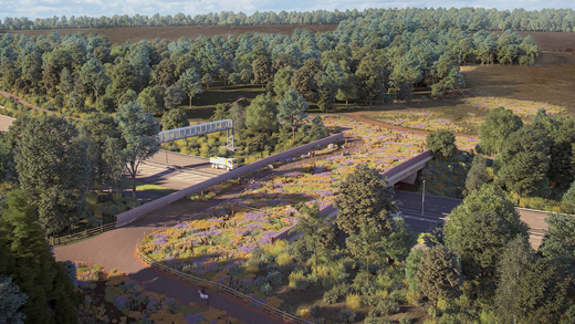
Visualisation of Cockcrow green bridge – viewpoint from Ockham Common (east) (©AtkinsRéalis/National Highways)
Visualisation of Cockcrow green bridge – viewpoint from Ockham Common (east) (©AtkinsRéalis/National Highways)
4. Engineering
In addition to the local environment sensitivities, the green bridge’s exact positioning was severely limited by several other existing constraints. The alignment of the A3 carriageways and adjacent local access roads, along with the associated safety forward visibility and sign and signal visibility requirements, restricted the bridge to a similar corridor as that for the existing much narrower footbridge. One such constraint was the need for a new 25 m span gantry over the northbound carriageway nearby, which could not be itself moved due to requirements for it to be positioned a set distance from the junction. The existing Ockham Bites café on the south side and residents on the north side of the A3 further narrowed potential routes. The finalised position of the bridge is on the south side of M25 junction 10, approximately 25 m south of the existing Cockcrow Bridge.
One drawback of the final bridge position was that the local topography falls away from the A3. This means that the approach embankments to the bridge need to extend further, as the maximum approach gradient of 5° (needed for the requirements of NMUs) and the minimum headroom clearance under the bridge had to be complied with. The impact of long approach embankments, which could increase the extent of the DCO boundary and land take from the SPA, were mitigated by incorporating minimum radius alignment turns once off the bridge. Although mitigated, land take remained a principal concern, which limited the available ‘construction depth’ of the final bridge design.
With the bridge position and the alignment of the NMU route established, the structural arrangement options for the bridge could be explored with greater certainty. Many common structural arrangements could be discounted early in the design development. For example, a conventional single-span arrangement would require a deeper construction depth than allowed for by the vertical alignment of the NMU over the bridge and the minimum headroom requirements under the bridge. A feature bridge single-span arrangement, such as a cable-stayed bridge or thrust arch with hangers, could require less construction depth and fit the geometric constraints, but would add significant cost to the construction and future maintenance. Three-span and four-span arrangements would reduce the construction depth of the bridge but involve costly and visually intrusive additional piers. Additionally, three-span and four-span arrangements would not be compatible with the horizontal alignment requirements for the bridge location. A two-span arrangement perpendicular to the A3 carriageway was the design choice, as this provided a suitable construction depth while minimising cost and complexity for the whole life of the bridge.
Several bridge superstructure options were considered, although some were not suitable given the site- and project-specific constraints. A fully in situ reinforced concrete superstructure would require the deck to be temporarily supported on falsework during construction; this would require a continuous road closure for a significant period, which would not be permitted for the A3. A post-tensioned prestressed beam superstructure has risks associated with post-tensioning operations that are not necessary given the alternative options available. Steel composite box girders would be less economic compared with alternative options. Furthermore, the inside of the box would be classified as a confined space and would create undesirable health and safety risks for maintenance. Finally, a steel truss would be unpractical for the width of bridge required.
The two most appropriate superstructure options were precast pretensioned concrete beams and fabricated steel plate girders, both with a reinforced concrete deck slab. Both options had similar advantages, disadvantages and whole-life costing. A key advantage for both options is that they can be constructed with relatively short closures, needed for the installation of the beams, minimising disruption to road users. A precast pretensioned concrete beam with reinforced concrete deck slab was the design choice due to the form of construction being more like the existing retained A3 bridges within and adjacent to the scheme.
A key part of the final bridge design was the incorporation of integral connections at supports. The connections between the bridge superstructure and bridge substructure (i.e. abutments and pier) are to be cast in concrete, making fixed continuous connections. As the bridge deck expands and contracts due to environmental thermal changes, the substructure and earthwork fill behind the abutments (for the expansion case) will partially restrain this movement. Features such as cattle grids could still be implemented (to ensure cattle do not conflict with users of the bridge) but these are set back away from the bridge abutments.
With the bridge location, span arrangement and form of construction established, the specific loading on the bridge was the next key consideration, and there were many aspects that needed to be accounted for in the loading calculations. Heathland supports low-growing (often referred to as ‘dwarf’) shrubs that are shallow rooted compared with trees and this allowed a soil depth of 600 mm – less than for other green bridge types. However, the additional ‘soft landscaping’ features such as the dead-wood corridor and the sandstone boulders all had to be included in the loading calculations. The bridge engineers also had to consider climatic scenarios such as a thick layer of snow across the bridge deck. The loading from cattle that could be grazing on the bridge was also calculated.
The final proposed bridge design delivered a conventional, low-disruption and cost-effective solution that met all the technical and ecological requirements of the brief. There was an aspiration for the look and feel of the bridge to be distinctive and complement the idiosyncrasy of the proposal – a singular green bridge that connects two areas of unique character through a continuous heathland habitat. A drawback of this form of bridge construction is that there is limited scope to affect the general appearance, as the precast beam’s shape and surface finish cannot be modified. The bridge’s parapets, the balustrade each side of the bridge superstructure that make up nearly half of the external elevation, were identified as elements that could be developed to provide a positive visual impact both for users on the bridge and those travelling on the A3.
The proposed design of the parapets needed to achieve three main aims.
- ⊪
Not being visually invasive to the landscape proposal over the bridge but blending in with it.
- ⊪
Creating contrast and richness in comparison with other ordinary bridges normally found on highways.
- ⊪
Not invalidating tested parapet products, so the overall project programme was not affected by requiring approval for a non-standard approach or risking public safety through an unsafe parapet design.
Parapet design options were compared, considering factors such as geometry, finishes and level of compliance with technical standards. The approach of using parapet cladding with incorporated patterns was explored, as this is an effective means of telling a story about the uniqueness of this green bridge proposal. The option of bronze-coloured panels with laser-cut details to display an abstracted pattern of heather (Figure 6), to reflect the local vegetation, was developed that could be used to clad a proprietary fully tested and code-compliant parapet system. This unique proposal would create a landmark, seen by bridge users and people on the A3, allowing the road users below to know that they are arriving at junction 10 and are passing through a distinctive and attractive landscape (Figure 7).
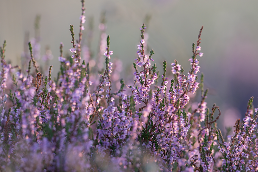
Close-up image of heather, which inspired the proposed balustrade motif (©AtkinsRéalis)
Close-up image of heather, which inspired the proposed balustrade motif (©AtkinsRéalis)
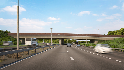
Visualisation of Cockcrow green bridge – external viewpoint from A3 northbound (© AtkinsRéalis/National Highways)
Visualisation of Cockcrow green bridge – external viewpoint from A3 northbound (© AtkinsRéalis/National Highways)
Ideas of using unpainted panels from Corten steel, bronze or copper were explored, to look at ‘organic-like’ finishes. It was concluded these could not be implemented without further significant safety testing, which would impact the overall programme. Instead, an oxide red powder coated steel panel was selected as the preferred cladding option due to its visual and performance properties (Figure 7). These panels have a look and feel similar to weathering steel panels but avoid the drawbacks of weathering steel such as potential uneven weathering and vulnerability to vandalism.
The final structural design, including the proposed parapet cladding, was costed by the scheme contractor (Balfour Beatty). This forecast the total cost of turning a standard replacement bridge into a 30 m wide green bridge (the ‘top up’ cost) to be £3.7 million.
5. Soils and landscaping
The green bridge design was developed with input from a wealth of stakeholders and specialist ecologists and engineers. Stakeholders helped define the ‘target species’ for the green bridge. The term target species refers to the species or types of species most likely to benefit from the bridge in the short to long term. Best practice suggests that target species may be critical to determining the width, design and vegetation for a green bridge. During early consultation with stakeholders, four key target species were identified: sand lizard, adder, silver-studded blue butterfly and heath tiger beetle.
These species are considerably smaller when compared with the mountain lions and elk targeted in green bridge examples from North America and Canada, but their requirements are complex. A functioning heathland with a mosaic of niche habitats (dwarf shrub cover, bare sand, acid grassland) supported by low-nutrient, dry, acidic soil conditions that allow the heathland to persist was required. The low-nutrient status will be delivered by sourcing the subsoil and topsoil (in the form of cut turfs, described below) from the construction footprint of the adjacent commons (safeguarded by detailed soil testing and habitat translocation methodologies designed by experts in these fields).
It was also important to provide cover for small animals, especially while the vegetation establishes, to mitigate the risk of the green bridge becoming a hotspot for predation. A line of up-ended tree stumps (also reclaimed from the construction works) will be placed towards the centre of the undisturbed corridor to the north to provide a safe route for wildlife moving across the bridge.
In addition to the needs of the target species, it is important that the green bridge also delivers for the sensitive landscape, and protects and enhances the character of the Thames Basin Lowlands National Character Area, within which it is situated. The soft landscaping on the bridge will consist of a wide (up to 20 m) corridor of habitat along its north side, where access will be restricted for the public (using stock-proof fencing) to create a connected habitat corridor with minimised disturbance (to the habitats and species present) from bridge users. The access road will meander alongside this corridor and will benefit from additional landscaping along the south side of the bridge, which will also function as a corridor for wildlife that is less sensitive to disturbance. Placing the track between two areas of soft landscaping and providing a gentle meander will allow bridge users to feel immersed in the nature present on both sides and reflects the surrounding landscape that is naturally undulating.
In addition to the size and layout of the green bridge, the type of soft landscaping used on the bridge is fundamental for the target species and ensuring their use of the bridge as a connective feature in the landscape, and for the continuity of the surrounding landscape for bridge users. An innovative and sustainable approach was taken to create the soft landscaping on the ‘heathland bridge’ by sourcing cut ‘turfs’ from the adjacent commons. Cutting turfs from heathland (a historic practice that used to provide a source of fuel and building materials for commoners) creates bare ground that is a vital habitat for a number of heathland specialist invertebrates and plants, and it helps creates age variation in vegetation by encouraging new growth. Therefore, with this approach, the commons benefit from the creation of small areas of scattered bare ground and the green bridge can be created without any reliance on plants or seed grown in nurseries (with the associated biosecurity risks and lack of local genetic diversity). This method also allows the natural mosaic of plants, root systems and seed banks to be moved with the turf and a proportion of the essential soil fungi and fauna. This aids the establishment of vegetation, which is quicker using turf than alternative seeding approaches. Specialist contractors will conduct the turf lifting and placement on the green bridge and are involved with the development of the design and methodology for this (Figure 8).
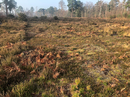
Heathland turf donor area on Wisley Common (©Ric Bossons, Alaska Ecological Contracting)
Heathland turf donor area on Wisley Common (©Ric Bossons, Alaska Ecological Contracting)
6. Lighting and drainage
All aspects of the design were scrutinised to ensure everything was done to enhance the user experience and maintain the functioning of the bridge as an ecological corridor. Lighting proposals were adapted to minimise light spill onto the bridge deck from adjacent new lighting columns and underlighting (a necessary requirement due to the width of the bridge) was positioned as sensitively as possible to provide ‘as dark a corridor as possible’ on the bridge deck and adjacent embankments.
The design of the drainage on and immediately off the bridge also needed to be carefully considered to ensure that wildlife crossing the structure will not become entrapped or have barriers to movement that would leave them vulnerable to predation or expend too much energy crossing impediments on their way to the bridge. Traditional gullies were not an option either on or off the bridge (they frequently entrap small animals, especially amphibians coming from or to breeding ponds and/or dispersing during the active season). On the west side of the green bridge, the new extensive embankment of heathland also required surface water attenuation provisions. A ‘dished verge’ was used on the bridge deck to channel any surface water flow from the new track to an interceptor chamber adjacent to the bridge abutments. Any water percolating through the heathland vegetation will also be captured in the same way. Drainage provisions along the tow of the Wisley embankment use filter drains rather than steep-sided drainage ditches. This creates a seamless corridor from the adjacent heathland up and over the green bridge.
Climatic concerns in the short term are associated with the increased likelihood of extreme weather events, such as heavy rainfall or drought, which could severely hamper habitat creation on the bridge. Lowland heathland is drought tolerant, so this is less of a concern than heavy rainfall. The drainage provisions on the bridge deck should allow for excess water to filter through the vegetation/dished verge and be channelled into suitable drainage infrastructure so as to ensure that the necessary dry conditions persist in the long term within the heathland corridor.
7. Stakeholders and legacy
The design of the green bridge was a collaborative experience, with many stakeholders participating in multiple workshops to ensure that the design considered all the potential risks and innovative ideas that could deliver for the target species. Every decision was made collectively, and when a final design was reached the support from all organisations was remarkable. A statement of support was produced and signed by a number of organisations, including The Wildlife Trusts, the Amphibian and Reptile Conservation Trust, Buglife, National Trust and the People’s Trust for Endangered Species. This support was influential for the Designated Funds application, as was the legacy that the partnership with SWT provided.
Lowland heath is a habitat that needs active management to keep it in good condition, supporting the low-growing shrubs that dominate it but with an essential proportion of open sandy areas that many of the rare species associated with heathland need for survival. SWT currently manage the heathland areas in Ockham and Wisley Commons on behalf of SCC. Wisley Common is managed with the aid of grazing cattle. Ockham Common is managed without cattle, currently using volunteer conservation parties and carefully managed mechanical control of vegetation. The fencing design on the green bridge will allow cattle from Wisley Common to graze the heathland on the bridge and on the slopes of the bridge embankment within Wisley Common (Figure 9). Grazing heathland creates habitat complexity and ecological niches, especially for small animals and invertebrates, so it is complementary to the ecological aims of the green bridge. For bridge users, it will also add to the feeling of being immersed in the historical commons with grazing animals surrounding them.
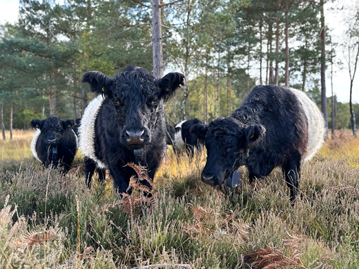
Belted Galloway, conservation grazing cattle used by SWT on Wisley Common (©Marcus Wehrle, SWT)
Belted Galloway, conservation grazing cattle used by SWT on Wisley Common (©Marcus Wehrle, SWT)
The scheme has made provisions for the management and monitoring of the habitats on the bridge and the surrounding areas for a period of 15 years. However, the long-term legacy of the green bridge relies upon the specialist management that the commons and now the green bridge will receive from the expertise and guardianship of SWT. This partnership is felt to be key to the long-term success of the structure, and the partnership extends to ecological monitoring of the wildlife using the green bridge so that others can benefit from the knowledge gained from this structure in the long term.
Allowing grazing on the bridge was an important part of its design. However, the bridge is multi-functional and it still had to provide the necessary infrastructure for NMUs (pedestrians, cyclists and equestrians). It was important that the associated fencing did not pose access restrictions for NMUs and the British Horse Society and SCC’s countryside access team worked closely with the green bridge designers to ensure that the needs of all users were considered. Specialist gates, horse mounting blocks and a cattle grid with associated fencing were all included in the design of the green bridge and these structures will be maintained for these users in the long-term (Figure 10).
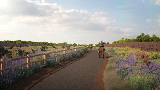
Visualisation of Cockcrow green bridge – internal viewpoint (©AtkinsRéalis/National Highways)
Visualisation of Cockcrow green bridge – internal viewpoint (©AtkinsRéalis/National Highways)
8. Conclusion
Construction of Cockcrow green bridge is currently underway. The design of the bridge and the successful funding application was a truly collaborative achievement involving many organisations, but it would not have been possible without the contributions of SWT, SCC and Natural England. Every green bridge has the potential to deliver great benefits to nature and enjoyment for people. The knowledge gained from designing, constructing and future monitoring of Cockcrow will aid those starting out on their green bridge journeys and inspire others to contribute to a nature-positive future by making our best habitat areas better connected (Figure 11).