

Award-winning work on the A30 Bodmin to Indian Queens improvement scheme, Cornwall, UK, has reduced the environmental impact of the road that forms the key arterial route for the county of Cornwall.
1. INTRODUCTION
The A30 trunk road is the principal route for all traffic travelling through the county of Cornwall, in south-west England. West of Bodmin, the original road was a single carriageway which was a notorious bottleneck, especially during the summer months. It also cut through the Goss Moor national nature reserve, a special area of conservation (SAC), protected under European law. The Highways Agency's objective for the improvement scheme to this section of the A30 was to reduce congestion and improve road safety while minimising impact on the environment.
Scott Wilson, the international multi-disciplinary consultancy group, was responsible for the scheme design, working with contractor Alfred McAlpine and client the Highways Agency. Throughout the design and construction process the project team worked closely to deliver the project ahead of schedule and within budget.
2. ENVIRONMENTAL FACTORS
To manage the wide range of issues, including archaeology, historic landscape, wildlife and associated habitats and groundwater, the team needed to consider the complex environmental factors of the site throughout every stage of planning, design and construction. The final alignment, developed from a series of option studies and public consultations by the client, was chosen primarily for environmental reasons.
The consultant's planning and design work on the A30 scheme received an award at the International Road Federation's (IRF) 2007 global road achievement awards, winning the environment mitigation category.1 The awards, established in 2000, are designed to demonstrate excellence and innovation in road development worldwide. The environment mitigation category is awarded to a team that shows outstanding progress in protecting and enhancing the natural environment in the planning, design and construction of a road development project. The award was presented to the team in October 2007 during the IRF's annual general meeting in Ft. Lauderdale, Florida, USA.
The A30 scheme comprises 11·5 km of new dual carriageway with two grade-separated junctions between the Indian Queens bypass and the Bodmin bypass. Nine major structures carry side roads and accesses over and under the new road (Fig. 1).
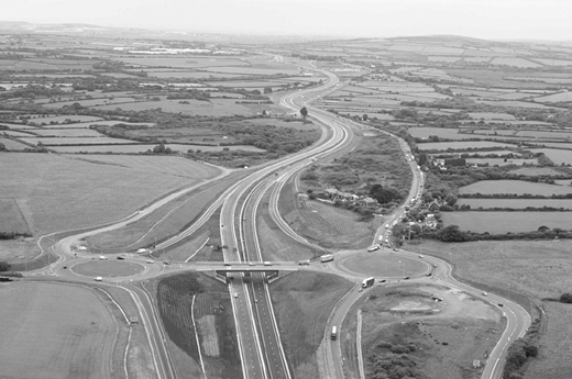
The new route design was deliberately chosen to avoid Goss Moor. The habitat has now been extended, regenerating the area and supporting such species as the endangered marsh fritillary butterfly. The road surface of the previous route through Goss Moor was replaced with new facilities for walkers, cyclists and horse-riders, opening up the moor to the public.
3. MITIGATION FEATURES
The entire area of the site is environmentally sensitive and many mitigation features have been included into the design. More than 6·5 km of new Cornish hedge were constructed as noise mitigation measures. These traditional boundaries date back to the neolithic age (4000–6000 years ago) and all were hand built to help maintain important heritage skills. They also provide invaluable habitat for numerous species, including the endangered dormouse.
Following extensive surveys prior to construction, additional features were incorporated into the design to protect the local wildlife. Thirteen crossings along the known migration paths of otters and badgers were built underneath the road. Artificial roosts were installed for the local bat population and will continue to be monitored for the next three years. Reptiles including adders, grass snakes and lizards were captured and released into the new protected conservation areas, with ‘reptile fencing’ erected to prevent them from getting too close to the road.
Extensive landscaping work was conducted to reflect and enhance the existing landscape character. Consultations with Natural England, English Heritage, the Environment Agency and Cornwall county council informed a landscape strategy that would provide functional mitigation through landscape features (such as the Cornish hedge) and expand the diversity of the existing habitats within the highway boundary. The techniques that were implemented included the reuse of moorland soils to extend the heathland, woodland planting to provide visual screening and the regrading of areas adjacent to junctions to return them for agricultural use.
The route crosses the headwaters of two highly sensitive rivers, the Fal and the Camel, and had the potential to disrupt their groundwater flows. The design incorporates a system of distribution ditches including numerous swales, balancing ponds and infiltration features to minimise the risk of flooding and ensure that all groundwater movements are maintained and not diverted or accelerated. Previously, surface water generated on the old road flowed into the watercourses of the rivers without any treatment.
As part of the environmental mitigation works, an intensive geophysical survey was carried out. Prior to construction, a 10 m wide section through the entire length of the site was stripped of topsoil and searched. In areas where finds were present the excavation was expanded. A series of open days were organised to allow local interest groups access to the excavations and a group of archaeology students from a local college worked on site for two weeks to gain work experience. Despite uncovering some significant finds, including the remains of a bronze age round house, progress to the project was not delayed. All of these finds were important as, to date, few artefacts and little evidence from the bronze age have been discovered in Cornwall.
Every effort was made to minimise waste during construction. The scheme was carefully designed to have a balance of cut and fill, eliminating the need to import and export material. Vegetation cleared for the new road was chipped and reused as mulch and existing roads no longer required were planed and the chippings reused for access tracks. All stone used in the build was sourced from neighbouring quarries. The stone is a waste product from the china clay industry, which is currently suffering a decline. Using this locally sourced material was of economic benefit to the local community, creating employment for the local workforce. In addition to the environmental benefits of these initiatives, the client also benefited economically through the reduced quantities of ‘virgin’ materials required and from reduced haulage costs.
During advanced works and construction a full-time environmental manager and environmental clerk of works were based on site to ensure correct implementation of mitigation measures and monitor environmental performance. The new road opened to traffic in July 2007.

