

Understanding the spatial distribution of water infrastructure heritage is crucial for its conservation in large regions. This study analyses 147 water infrastructure heritage sites in the Shandong section of the Yellow River Basin using an integrated nearest neighbour distance index (NNDI)–kernel density estimation (KDE)–GeoDetector framework. Spatial techniques, including NNDI and KDE, reveal that sites display a statistically significant clustered pattern described as ‘large aggregation, small dispersion’, forming a spatial layout of ‘three cores and one line’. GeoDetector analysis quantitatively shows that anthropogenic engineering factors, especially water infrastructure systems (q = 0.92), are the primary determinants of distribution, while natural geographical elements serve as secondary constraints. This integrated framework outperforms traditional single-method analyses, offering a robust tool for conservation planning, sustainable tourism, and heritage management in complex river basins. The methodology also provides a transferable model for analysing water infrastructure heritage in other major river systems globally.
Notation
nearest neighbour distance index
distance between the actual nearest heritage sites
distance between the jth heritage site and the nearest heritage site
- >0
bandwidth
kernel functions
classifications number of the th influencing factors
sample size of water infrastructure heritage
type number of the th influencing factors
total number of heritage sites
estimate the spatial density distribution of water infrastructure heritage sites in the Shandong section of the Yellow River Basin
number of heritage sites
variance of water infrastructure heritage
variance of the th influencing factors
the explanatory power of influencing factor indicators on the spatial distribution of water infrastructure heritage, with higher values indicating stronger correlations, where
area of the heritage site area
sample point drawn from the population with distribution density function
distance from the valuation point to the inheritance point
average distance between the actual nearest heritage sites
theoretical nearest average distance
Introduction
The Yellow River Basin, the birthplace of Chinese civilisation, possesses extensive water infrastructure systems and rich water-related heritage that embody centuries of traditional water management wisdom. In history, the Yellow River has changed its course many times, extending vertically and horizontally, and the water systems on both banks have been disrupted repeatedly. The ancestors of Qilu have gradually developed sophisticated water management technologies in the process of repeatedly approaching, using, controlling and managing water systems, and have produced a large number of Yellow River water infrastructure heritage bearing engineering innovations and technical knowledge. These represent important examples of traditional water management practices and a concentrated embodiment of the cultural and technical achievements in water infrastructure development of the Yellow River basin. Such heritage sites serve not only as physical testaments to historical hydraulic capabilities but also as valuable repositories of traditional knowledge for understanding human–water relationships and sustainable water management approaches that remain relevant in contemporary contexts.
The Yellow River serves as a major artery that carries the innovations of Chinese water management and demonstrates advanced technologies developed over millennia. The recognition of this heritage's significance has been reinforced by recent national policy initiatives emphasising heritage conservation and sustainable development. On 18 September 2019, General Secretary Xi Jinping made a highly summarised and insightful exposition on the protection, inheritance, and promotion of Yellow River culture at the symposium on ecological protection and high-quality development in the Yellow River Basin. He emphasised the need to promote the systematic protection of Yellow River water infrastructure heritage and safeguard the precious engineering heritage left by our ancestors (Xi, 2019). In October 2021, the Outline of the Plan for Ecological Protection and High-quality Development of the Yellow River Basin clearly proposed to focus on protecting the water infrastructure heritage resources along the Yellow River, continuing the historical context and engineering innovations (CCCPC and State Council, 2021). These policy frameworks underscore the urgent need for systematic research to support evidence-based heritage conservation planning and management. The Shandong section of the Yellow River Basin is located at the end of the 10,000-mile Yellow River, with a total length of 628 km, accounting for 11.5% of the total length of the Yellow River. It flows through nine cities including Heze, Jining, Tai’an, Liaocheng, Jinan, Dezhou, Zibo, Binzhou, and Dongying (CPC Shangdong and SDPG, 2022). This region presents a particularly significant case for water infrastructure heritage spatial analysis due to its concentration of diverse water infrastructure types and complex historical patterns of river course changes.
Despite the cultural and scientific importance of water infrastructure heritage, research in this domain remains at an early stage of development. The research on heritage in the Yellow River Basin is still developing, and the content mostly involves the technical analysis and engineering applications of heritage infrastructure (Jiang, 2022). In terms of national cultural park heritage (Wang et al., 2023a), rural infrastructure heritage (Tian et al., 2023), revitalisation of ancient engineering systems (Wu et al., 2021), Yellow River archaeology (Hou et al., 2020), intangible water infrastructure heritage (Tian et al., 2022; Wang et al., 2023b), and integration of heritage and engineering applications (Shao et al., 2022; Wang and Li, 2023); however, research highlighting the theme of water infrastructure heritage using advanced geospatial analysis is even rarer. In terms of research content, the study of the Yellow River water infrastructure heritage mainly involves the composition, protection, and utilisation of water conservancy engineering systems (Mu et al., 2022; Wang, 2022; Zhao et al., 2021), with relatively little research on spatial distribution modelling, heritage conservation planning, and systematic analytical approaches; in terms of research objects, intangible water infrastructure heritage is mainly used, and there are relatively few studies on tangible infrastructure heritage; In terms of research methods, cultural anthropology (Li et al., 2021; Liu, 2009), folklore (Wang et al., 2024a; Wei and Zhu, 2022; Zhang, 2021), geography (Xiang, 2004; Yang, 2003), and other commonly used fields are mainly used, while advanced geographic information system (GIS) modelling and spatial analysis techniques remain underutilised. In terms of geographic scope, existing research primarily focuses on individual provinces such as Henan or Shanxi (Liu, 2004; Mu et al., 2010; Tian, 2012; Wu, 2004; Zhang et al., 2016), often examining isolated urban centres (Hu et al., 2015; Pu and Xiao, 2016) or rural settlements (Ding, 2020) rather than employing basin-wide spatial analysis or cross-regional systematic approaches (Mang and Liu, 2019). This limited analytical perspective requires expansion to support comprehensive heritage conservation and management strategies.
Existing analytical approaches in this field primarily include the concentration index (Gao, 2017), buffer analysis (Dai et al., 2013), kernel density estimation (KDE) (Xu and Pan, 2018), and nearest neighbour distance index (NNDI) (Zhang et al., 2017). The integration of these methods into comprehensive analytical frameworks can provide more robust spatial analyses. However, advanced spatial modelling methods represented by GeoDetector remain underutilised in this domain (Jiang et al., 2019). GeoDetector offers unique advantages in revealing key factors influencing heritage spatial distribution and their interactive mechanisms through quantitative analysis (Hao et al., 2018; Miao and Zhang, 2014). Integrated analytical frameworks based on this method still require further development for heritage conservation applications. Most existing studies focus on single analytical methods, lacking integrated approaches that combine multiple spatial techniques to provide a comprehensive understanding of heritage distribution patterns and their driving factors.
Considering that ecological protection and high-quality development have become a national strategy for the Yellow River Basin (Wang et al., 2024b), there is an urgent need for systematic spatial analysis to support heritage conservation planning and sustainable management in this region. This study focuses on the nine prefecture-level cities along the main and tributary rivers of the Yellow River in Shandong Province as its research area, with immovable material water infrastructure heritage as the research object. Using advanced GIS-based spatial analysis methods and ArcGIS software, this study analyses the spatial distribution characteristics of the material water infrastructure heritage in the Shandong section of the Yellow River Basin, explores its spatial distribution patterns through integrated analytical modelling, and provides scientific references and decision making support for heritage conservation planning and integrated management. Specifically, this research aims to: (1) quantify spatial distribution characteristics and clustering patterns using NNDI and KDE; (2) identify key factors influencing heritage distribution and their relative importance through GeoDetector analysis; (3) establish an integrated analytical framework combining multiple methods for comprehensive infrastructure heritage spatial analysis; (4) propose evidence-based recommendations for differentiated conservation and management strategies and priority area identification. By revealing the spatial logic underlying water infrastructure heritage distribution, this study seeks to support the systematic protection and sustainable utilisation of Yellow River water infrastructure heritage, contributing to the broader goals of heritage conservation and the construction of the Yellow River National Cultural Park in Shandong Province.
Materials and methods
Data processing
The region and object studied in this study are the immovable water infrastructure heritage along the Yellow River in Shandong. From 2018 to 2020, the Shandong Yellow River Bureau conducted a systematic excavation and sorting, and published the ‘Compilation of Shandong Yellow River Water Infrastructure Heritage’, which included 147 infrastructure heritage sites (Guo, 2020). This article takes these sites as its research sample. These heritage sites represent diverse manifestations of traditional water management practices, ranging from ancient hydraulic structures to historical settlements, each bearing unique cultural and technical significance. On this basis, based on the individual characteristics and cultural connotations of the sample heritage, they were summarised and classified into four categories and ten subcategories: water conservancy projects and their ancillary projects, water culture settlements and architectural sites, water culture landscapes, and red revolutionary heritage (Table 1). By conducting field investigations on the samples and utilising the Gaode development platform (Link to lbs.amapLink to the cited article) to obtain the geographical coordinate information of the water infrastructure heritage in the Shandong section of the Yellow River Basin, and organise it into an independent geographical coordinate set based on the classification of ten subcategories, in order to analyse its spatial distribution characteristics.
Characteristics of water infrastructure heritage types
| Major categories | Subclass | Typical heritage list |
|---|---|---|
| Water conservancy engineering and its ancillary works | Dam and embankment dangerous workers | Dangdong Embankment, Taihang Embankment, Dongping Lake Second level Embankment, Nanjin Embankment, Beijin Embankment, Jiujin Embankment, Chenggong Embankment, Daicun Dam, Yancheng Dam, Dong'ahuoliu Dam, Xuewang Shaoxian Gravity Mortar Masonry Dam, Gaowanlin Dam, Dongming Shundi Flood Protection Project, Dongdi Dangerous Construction, Taochengpu Dangerous Construction, Yangzhuang Dangerous Construction, Luokou Dangerous Construction, Gaijiagou Dangerous Construction, Tiziba Dangerous Construction, Liuchunjia Dangerous Construction, Mazazi Dangerous Construction, Wangzhuang Dangerous Construction, Yellow River North Widening Project, Yellow River South Widening Project, Shandong Yellow River Phase I Standardized Embankment Project |
| River and lake old course | The ‘Tofu Waist’ section, Aishan Pass, Yellow River Throat, Daqing River, Liaocheng Ancient Canal, Jindi River, Yufu River, Liangshanbo, Daotunwa, Dongchang Lake, Danxian Fulong Lake, Huantai Mata Lake, Dongping Lake Flood Storage and Detention Area, Beijindi Flood Storage Area, Jishui Old Road, Hekou Yellow River Old Road, Shenshenggou Flow Road, Diaokou River Road | |
| Water gate tunnel bridge | Liaocheng Ancient Canal Ship Lock, Zhangqiu Lock, Shiwa Flood Diversion Lock, Chenshankou Lake Exit Lock, Shandong Yellow River Floating Bridge, Luokou Yellow River Railway Bridge | |
| Water culture settlements and architectural sites | Stone carvings and steles | Huize Changliu Stele, Gaocun Helongchu Stele, Luokou Zhihuang Dezheng Stele, Xiaoyanzhuang Tragedy Memorial Monument, Wuzhuang Breach and Blockage Memorial Monument |
| Ancient city ferry | Dongpingzhou City, Dongchang Ancient City, Dong'a Ancient Town, Linji Ancient Town, Qidong Ancient City, Putai Ancient City, Jiangjun Ferry, Dongjin Ferry, Luokou Ancient Ferry, Old City Ferry, Kenli No.1 Dam Ferry, Liaocheng Ancient Canal Dock | |
| Water culture landscape | Water cultural venues | Queshan Reservoir, Yuqing Lake Reservoir, Susizhuang River Control Historical Park, Nanhua Zhuangzi Temple, Haiyuan Pavilion |
| Celebrity residences, ancestral halls, cemeteries | Tomb of Xiang Yu, Tomb of Cao Zhi, Tomb of Bianque, Temple of Yu Wang in Ningyang, Temple of Dragon King in Nanwang Fenshui | |
| Red revolution heritage | Heritage site | Former Residence of Yu Zuotang, Kuiqiu Huimengtai, Jiangsu Dam Site, Yongji Bridge Site, Jinxianling Site, Tiemenguan Site |
| Memorial hall, cultural centre | Revolutionary Memorial Hall of the Hebei Shandong Henan Border Region, Memorial Hall of the Battle of Maling, Yellow River Culture Museum, and Memorial Hall of Visiting Baichuan | |
| Museums and exhibition halls | Daicunba Museum, Jinan Yellow River Culture Exhibition Hall, Yellow River Dongyin Railway Culture Exhibition Hall |
Research methods
Nearest neighbour distance index method
The NNDI was selected for its effectiveness in objectively quantifying spatial clustering patterns, which is essential for identifying heritage concentration areas requiring priority conservation efforts. The NNDI is one of the statistical methods for analysing point distribution, which can be used to evaluate the spatial patterns of points distribution (Wang et al., 2017). The calculation formula is:
In the formula, is the nearest neighbour distance index, is distance between the actual nearest heritage sites is the average distance between the actual nearest heritage sites, is the theoretical nearest average distance, is number of heritage sites, is the area of the heritage site area, is density of heritage sites, is the distance between the heritage site and the nearest heritage site. According to Equations 1–3, the average nearest neighbour tool in ArcMap 10.2 software was used to perform spatial analysis of various types of water infrastructure heritage in the Shandong section of the Yellow River Basin, and to calculate the average NNDI. If the result is greater than 1, it indicates that the heritage sites are distributed in a dispersed manner; it equals 1 indicates a random distribution; it is less than 1 indicates a clustered distribution.
Nuclear density estimation method
KDE was employed to visualise spatial concentration gradients, enabling identification of heritage ‘hotspots’ that may require intensive conservation resources and management attention. KDE is a non-parametric statistical method that estimates the density distribution of the entire dataset based on the local density around sample data points. This study uses to estimate the spatial density distribution of water infrastructure heritage sites in the Shandong section of the Yellow River Basin.
In the formula is the sample point drawn from the population with distribution density function , is kernel functions > 0 is the bandwidth, is the total number of heritage sites, is the distance from the valuation point to the inheritance point (Cheng and Ling, 2013). According to Equation 4, the kernel density analysis (spatial analysis) tool in ArcMap 10.2 software was used to perform spatial analysis of various types of water infrastructure heritage in the Shandong section of the Yellow River Basin, and a kernel density distribution map was obtained.
Geographic detector
GeoDetector was chosen for its unique capability to analyse both individual and interactive effects of multiple factors without assumptions of linear relationships, making it particularly suitable for understanding complex heritage distribution patterns influenced by diverse natural and anthropogenic factors. GeoDetector is a statistical method for spatial analysis that can detect and quantify the spatial heterogeneity of geographic phenomena and the explanatory power of various influencing factors contributing to this heterogeneity. This approach enables researchers to identify key factors affecting spatial distribution patterns. Through its analytical framework, GeoDetector examines both the individual spatial differentiation of single factors and explores the interactive coupling relationships between multiple factors. By utilising the interaction of geographic detectors, the explanatory power of the coupling and feedback relationship between factors on the spatial distribution of water infrastructure heritage in the Yellow River Basin can be obtained (Mu et al., 2022). This article uses the q-value to estimate the influencing factors of the spatial distribution of water infrastructure heritage in the Shandong section of the Yellow River Basin. The calculation formula is:
In the formula, and are, respectively, the sample size and variance of water infrastructure heritage; and are, respectively, the type number and variance of the th influencing factors; is the classifications number of the th influencing factors. is the explanatory power of influencing factor indicators on the spatial distribution of water infrastructure heritage, with higher values indicating stronger correlations, where. According to Equation 5, the GeoDetector software was used to perform quantitative analysis of the influencing factors of the spatial distribution of various types of water infrastructure heritage in the Shandong section of the Yellow River Basin, and to calculate q-values, which provide quantitative evidence for identifying priority factors in heritage conservation planning.
Results and analysis
Urban distribution characteristics of water infrastructure heritage in the Shandong section of the yellow river basin
According to the ‘Shandong Province Yellow River Ecological Corridor Protection and Construction Plan (2023–2030)’ released by the Shandong Provincial Government, the nine cities flowing through the Yellow River Basin in Shandong are divided into three sections, namely, Heze, Jining, and Tai'an in the upper section; The middle section includes Liaocheng, Jinan, Dezhou, Zibo, and Binzhou; the lower section is Dongying (SDPG, 2023). In terms of quantity distribution, the middle section has the most water infrastructure heritage, reaching 80 sites, accounting for 54.4%; Next is the upper section, with 54 items, accounting for 36.7%; There are at least 13 downstream items, accounting for only 8.8% (Figure 1).
 The choropleth map of Shandong Province displays the spatial distribution of counts associated with the Yellow River corridor. City boundaries, railways, tributaries, the principal course of the Yellow River, and subsidiary lakes are marked across the province. Cities including Jinan, Liaocheng, Taian, Dongying, Binzhou, Heze, Qingdao, Yantai, and Rizhao are labelled. Darker shaded regions are concentrated along the Yellow River corridor near Jinan, Liaocheng, Taian, and Dongying, indicating higher counts ranging from 31 to 32, while eastern coastal regions show lower or zero values. A north arrow and a scale bar from 0 to 180 kilometres are included.
Distribution of the quantity of water infrastructure heritage
The choropleth map of Shandong Province displays the spatial distribution of counts associated with the Yellow River corridor. City boundaries, railways, tributaries, the principal course of the Yellow River, and subsidiary lakes are marked across the province. Cities including Jinan, Liaocheng, Taian, Dongying, Binzhou, Heze, Qingdao, Yantai, and Rizhao are labelled. Darker shaded regions are concentrated along the Yellow River corridor near Jinan, Liaocheng, Taian, and Dongying, indicating higher counts ranging from 31 to 32, while eastern coastal regions show lower or zero values. A north arrow and a scale bar from 0 to 180 kilometres are included.Distribution of the quantity of water infrastructure heritage
Among them, Jinan City has the largest number of water infrastructure heritage, reaching 32 items, accounting for 21.8%; Heze, Tai'an, and Liaocheng have a considerable number of water infrastructure heritage, accounting for 15%–20%; The water infrastructure heritage in Jining, Binzhou, Dongying, and Zibo cities is relatively small, accounting for 4%–10%; The water infrastructure heritage in Dezhou City is the least, with only five items, accounting for the lowest proportion of only 3.4%. From the distribution of types, Liaocheng City has the highest distribution of heritage sites related to dam and dangerous engineering, as well as ancient river and lake channels; the distribution of heritage sites such as water gate entrances, stone carvings, and ancient city ferries is most abundant in Jinan city; the distribution of water infrastructure heritage sites is highest in Jinan and Heze cities; the distribution of celebrity residences, ancestral halls, and cemeteries is most abundant in Jining and Tai'an cities; the distribution of heritage sites, memorial halls, and cultural centres is most abundant in Heze City; the distribution of museums and exhibition halls is highest in Tai'an City (Table 2).
Distribution of the number of water infrastructure heritage sites
| Region | City area | Type | Close meter/item | Occupy than/% | |||||||||
|---|---|---|---|---|---|---|---|---|---|---|---|---|---|
| Water conservancy engineering and ancillary works | Water culture settlement and architectural sites | Water culture scenery | The red revolution heritage | ||||||||||
| Dam and embankment dangerous workers | River and Lake Old Course | Water gate entrance | Stone moment stone monument | Ancient city ancient crossing | Water cultural venues | Celebrity residences, ancestral halls, cemeteries | Heritage site | Memorial Hall, cultural center | Museum exhibition hall | ||||
| Upper section | Heze | 3 | 3 | 1 | 3 | 2 | 2 | 0 | 6 | 2 | 0 | 22 | 15.0 |
| Jining | 1 | 2 | 0 | 3 | 0 | 0 | 2 | 1 | 0 | 0 | 9 | 6.1 | |
| Tai'an | 2 | 3 | 7 | 4 | 1 | 0 | 2 | 1 | 1 | 2 | 23 | 15.6 | |
| Middle section | Liaocheng | 6 | 5 | 5 | 1 | 2 | 1 | 1 | 5 | 1 | 1 | 28 | 19.0 |
| Jinan | 5 | 2 | 7 | 6 | 4 | 2 | 1 | 4 | 0 | 1 | 32 | 21.8 | |
| Dezhou | 1 | 1 | 1 | 0 | 0 | 1 | 0 | 1 | 0 | 0 | 5 | 3.4 | |
| Zibo | 2 | 1 | 2 | 0 | 0 | 1 | 0 | 0 | 0 | 0 | 6 | 4.1 | |
| Binzhou | 2 | 0 | 1 | 2 | 2 | 0 | 0 | 1 | 1 | 0 | 9 | 6.1 | |
| Next section | Dongying | 2 | 2 | 2 | 2 | 1 | 0 | 0 | 3 | 1 | 0 | 13 | 8.8 |
| Total | 24 | 19 | 26 | 21 | 12 | 7 | 6 | 22 | 6 | 4 | 147 | 100 | |
Distribution characteristics of water infrastructure heritage density in the Shandong section of the Yellow River Basin
Overall density distribution
By using kernel density analysis, the overall kernel density distribution map of the water infrastructure heritage in the Shandong section of the Yellow River Basin can be obtained (Figure 2). As illustrated in Figure 2, the overall kernel density distribution of water infrastructure heritage in the Shandong section of the Yellow River Basin exhibits a spatial pattern of ‘large aggregation and small dispersion’. This distribution demonstrates significant spatial autocorrelation (Zhang et al., 2022), particularly evidenced by a prominent high-density cluster at the convergence of Liaocheng, Jining, and Tai'an borders; it forms high-density core area centred around the border between Jinan and Dezhou; and forms low-density core area centred around Dongying. Except for the core area, there are scattered distributions along the Yellow River Basin in the eastern section of the mountain. Overall, the distribution of Kernel density forms a spatial pattern of ‘three nuclei and one line’.
 The thematic map of Shandong Province displays the distribution of material water cultural heritage sites marked by circular points along the Yellow River system. Railways, tributaries, principal tributaries, the principal course of the Yellow River, subsidiary lakes, and city boundaries are shown. The highest concentration of heritage sites occurs along the Yellow River corridor near Jinan, Liaocheng, Dongying, and Taian, with density shading increasing around these clusters. Cities including Heze, Binzhou, Qingdao, Rizhao, and Yantai are labelled. The legend presents density values ranging from 0 to approximately 0.024129793. A north arrow and a scale bar from 0 to 180 kilometres are included.
Overall nuclear density distribution of water infrastructure heritage
The thematic map of Shandong Province displays the distribution of material water cultural heritage sites marked by circular points along the Yellow River system. Railways, tributaries, principal tributaries, the principal course of the Yellow River, subsidiary lakes, and city boundaries are shown. The highest concentration of heritage sites occurs along the Yellow River corridor near Jinan, Liaocheng, Dongying, and Taian, with density shading increasing around these clusters. Cities including Heze, Binzhou, Qingdao, Rizhao, and Yantai are labelled. The legend presents density values ranging from 0 to approximately 0.024129793. A north arrow and a scale bar from 0 to 180 kilometres are included.Overall nuclear density distribution of water infrastructure heritage
Density distribution of various types
Due to the differences in historical culture, regional population, geographical terrain, and environmental characteristics of the Yellow River basin along the Shandong section, the density distribution of different types of water infrastructure heritage shows an uneven distribution with significant differences in distribution range (Figure 3). The spatial and temporal distribution of water infrastructure heritage is the result of the combined action of natural geographical environment such as climate change, topography, river hydrology, and humanistic environment such as administrative institutional changes, ideological evolution, and social and economic development (Li et al., 2022). The density distribution of water infrastructure heritage such as dam dangerous works, stone carvings, museums and exhibition halls, and water gate openings is most concentrated at the junction of Liaocheng and Tai'an, as well as in Jinan and Dongying; the density distribution of water infrastructure heritage in the old river and lake channels is most concentrated at the junction of Tai'an, Liaocheng, Jinan, and Dongying; the density distribution of ancient city and ferry water infrastructure heritage is most concentrated in Binzhou and Dongying; the density distribution of water infrastructure heritage sites is most concentrated at the junction of Jining, Liaocheng, and Tai'an cities, as well as in Heze; the density distribution of water infrastructure heritage such as memorial halls and cultural centres is most concentrated in Heze and Dongying; the density distribution of water infrastructure heritage sites is most concentrated in Jinan and Dezhou. In addition, the density distribution of water infrastructure heritage such as celebrity residences, ancestral halls, and cemeteries is mainly single point distribution, mainly distributed in Jining, Tai'an, and Jinan.
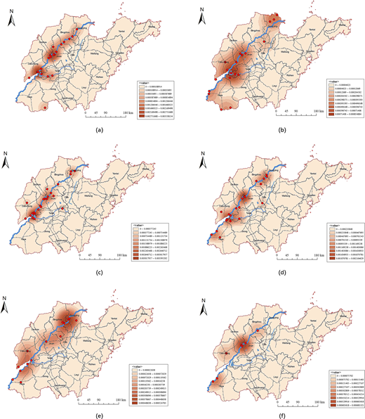
Distribution map of various nuclear densities of water infrastructure heritage: (a) dam and embankment dangerous workers; (b) river and lake old course; (c) water gate entrance; (d) stone moment stone monument; (e) ancient city ancient crossing; (f) water cultural venues; (g) celebrity residences, ancestral halls, cemeteries; (h) heritage site; (i) memorial hall, cultural center; (j) museum exhibition hall
Distribution map of various nuclear densities of water infrastructure heritage: (a) dam and embankment dangerous workers; (b) river and lake old course; (c) water gate entrance; (d) stone moment stone monument; (e) ancient city ancient crossing; (f) water cultural venues; (g) celebrity residences, ancestral halls, cemeteries; (h) heritage site; (i) memorial hall, cultural center; (j) museum exhibition hall
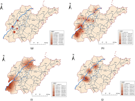
From Figure 3, it can be seen that different types of water infrastructure heritage exhibit different spatial distribution patterns. The heritage sites of dam dangerous works and water gate openings are basically distributed in a strip pattern along the Yellow River; the stone tablet heritage is mainly distributed in clusters along the three core areas of the Yellow River Basin; heritage sites such as water infrastructure sites, celebrity residences, ancestral halls, cemeteries, museums, and exhibition halls are generally distributed in a point-like pattern along the Yellow River Basin; heritage sites such as ancient rivers and lakes, ancient city ferries, and scenic spots are mainly distributed in patches along the Yellow River basin.
Spatial structure characteristics of water infrastructure heritage in the Shandong section of the Yellow River Basin
By using the nearest neighbour index method and the average nearest neighbour tool in ArcMap 10.2 software, 147 heritage samples were calculated. The overall average nearest neighbour index value of the water infrastructure heritage in the Shandong section of the Yellow River Basin was found to be 0.50, indicating that the spatial structure of the distribution of water infrastructure heritage in the Shandong section of the Yellow River Basin presents an overall clustering feature. However, the distribution of the four types of water infrastructure heritage, namely, water conservancy engineering and its ancillary projects, water cultural settlements and architectural sites, water cultural landscapes, and red revolutionary heritage, is not consistent in spatial structure, and there are some differences (Figure 4). Among them, the heritage of water conservancy engineering and its ancillary projects (C value = 0.57) and the heritage of water culture settlements and architectural sites (C value = 0.77) show a clustered distribution characteristic; the clustering of water cultural landscape heritage (C value = 0.82) is weak and tends to be randomly distributed; the Red Revolution heritage category (C value = 1.02) exhibits a dispersed distribution characteristic. From the perspective of the ten categories of heritage, there are also significant differences in spatial distribution structure. Among them, the heritage values of ancient city ferries and stone inscriptions are 0.15 and 0.77, respectively, showing a clustered distribution pattern; the heritage values of ancient river and lake channels, dangerous dams, scenic spots, and water gate entrances range from 0.88 to 1.05, approaching 1, with weak clustering and a random distribution pattern; museums, exhibition halls, memorial halls, cultural centres, celebrity residences, ancestral halls, cemeteries, and water cultural sites have NNDI values ranging from 1.52 to 3.02, with the weakest clustering and a dispersed distribution pattern (Table 3).
 The four-panel statistical figure labelled A to D presents nearest neighbour analysis results comparing clustered, random, and dispersed spatial distribution patterns. Each panel contains a bell-shaped significance distribution with coloured significance zones, nearest neighbour ratio values, z-scores, and p-values. Panel A shows a clustered distribution with nearest neighbour ratio 0.571715, z-score minus 6.706574, and p-value 0.000000, indicating strong clustering with less than 1 percent likelihood of randomness. Panel B presents a random distribution with nearest neighbour ratio 0.815578 and p-value 0.203344. Panel C indicates clustered behaviour with nearest neighbour ratio 0.768953, z-score minus 2.539150, and p-value 0.011112, suggesting less than 5 percent likelihood of randomness. Panel D displays a random pattern with nearest neighbour ratio 1.021077 and p-value 0.828099. Each panel includes schematic examples of clustered, random, and dispersed point arrangements.
Nearest neighbour index of the four major types of water infrastructure heritage: (a) water conservancy engineering and its ancillary projects; (b) water culture settlements and architectural sites; (c) water culture landscape category; (d) red revolution heritage category
The four-panel statistical figure labelled A to D presents nearest neighbour analysis results comparing clustered, random, and dispersed spatial distribution patterns. Each panel contains a bell-shaped significance distribution with coloured significance zones, nearest neighbour ratio values, z-scores, and p-values. Panel A shows a clustered distribution with nearest neighbour ratio 0.571715, z-score minus 6.706574, and p-value 0.000000, indicating strong clustering with less than 1 percent likelihood of randomness. Panel B presents a random distribution with nearest neighbour ratio 0.815578 and p-value 0.203344. Panel C indicates clustered behaviour with nearest neighbour ratio 0.768953, z-score minus 2.539150, and p-value 0.011112, suggesting less than 5 percent likelihood of randomness. Panel D displays a random pattern with nearest neighbour ratio 1.021077 and p-value 0.828099. Each panel includes schematic examples of clustered, random, and dispersed point arrangements.Nearest neighbour index of the four major types of water infrastructure heritage: (a) water conservancy engineering and its ancillary projects; (b) water culture settlements and architectural sites; (c) water culture landscape category; (d) red revolution heritage category
Average nearest neighbour index of water infrastructure heritage
| Ten subcategories | Dam and embankment dangerous workers | River and lake old course | Water gate entrance | Stone carvings and steles | Ancient city ferry | Water cultural venues | Celebrity residences, ancestral halls, cemeteries | Heritage site | Memorial hall, cultural centre | Museums and exhibition halls | Total |
|---|---|---|---|---|---|---|---|---|---|---|---|
| quantity | 24 | 19 | 26 | 21 | 12 | 7 | 6 | 22 | 6 | 4 | 147 |
| C value | 0.86 | 1.01 | 0.90 | 0.77 | 0.15 | 1.58 | 1.52 | 0.99 | 1.86 | 3.02 | 0.50 |
| P value | 0.19 | 0.88 | 0.37 | 0.03 | 0.00 | 0.01 | 0.02 | 0.97 | 0.00 | 0.00 | 0.00 |
These typological differences in spatial structure have important implications for infrastructure heritage conservation planning. Clustered heritage types (such as water conservancy engineering and stone inscriptions with C values < 0.80) may benefit from area-based protection strategies and integrated management zones. In contrast, dispersed heritage types (such as memorial halls and museums with C values >1.50) require point-specific conservation measures coordinated with broader urban and rural planning frameworks. The random distribution pattern of water cultural landscapes (C value = 0.82) suggests the need for flexible conservation approaches that can adapt to diverse local contexts.
Influencing factors
The formation, development, and spatial distribution of water infrastructure heritage are closely related to natural geographical factors and socioeconomic and cultural factors (Xu and Pan, 2018). It is the result of spatial differences of natural and cultural environments within the watershed (Wang et al., 2023a). Previous studies have shown that geographical environmental factors such as river systems and terrain, as well as social and cultural factors including road density, gross domestic product, population density, and urbanisation level, significantly impact heritage spatial distribution in the Yellow River Basin (Nie et al., 2022). Based on the actual situation of the Shandong section and relevant literature, this study analyses the influencing factors from two dimensions of natural geography and social culture, using five specific indicators. The main natural geographical factors include terrain and landforms, as well as rivers; the socioeconomic and humanistic factors mainly include economic development level, water conservancy engineering, and culture (Table 4). These factors have been demonstrated to influence heritage distribution patterns in various contexts (Chun et al., 2021; Kang et al., 2022; Wu et al., 2015, 2023). The spatiotemporal distribution pattern of heritage is generated by the interaction of various natural, economic, social, and cultural driving factors (Huang and Yang, 2023).
Influencing factors and explanatory power of factors
| Dimension | Index | Evaluating indicator | Data sources | Q value |
|---|---|---|---|---|
| Natural geographical factors | Topographic features | Altitude | Geospatial data cloud DEM data | 0.38 |
| Rivers | Water system density, old course of rivers | Geospatial data cloud DEM data | 0.86 | |
| — | — | Shandong Province Water Resources Journal 2018 | — | |
| Socioeconomic factors | Economic development level | Regional Gross Domestic Product and Urbanisation Rate | Shandong Statistical Yearbook 2022 | 0.36 |
| Water conservancy project | Dock ferry, sluice gate entrance, dam dangerous works | — | — | |
| Culture | Ancient settlements, memorial halls, museums, historical sites | Shandong Province Water Resources Journal 2018 | 0.92 | |
| — | — | Historical documents, field surveys | 0.89 |
The q values shown in Table 4 were calculated by the GeoDetector software, and the larger the value, the stronger the explanatory power of the influencing factor indicators on the spatial distribution of heritage. The types of heritage are influenced by both natural and cultural factors during their evolution, including altitude, canals, population, water transportation, and historical heritage elements.
Among natural environmental factors, river factors (q = 0.86) are the strongest influencing indicators the water infrastructure heritage of the Shandong section. This indicates that abundant water resources are a necessary condition for the formation and development of water infrastructure heritage, with high density river systems corresponding to the most densely distributed heritage areas. The rivers that were diverted multiple times in history have left behind substantial water infrastructure heritage.
Among socioeconomic factors, the water conservancy engineering factor (q = 0.92) is the strongest influencing indicators, suggesting that historical water management activities represent the primary driver of heritage distribution. This dominant role indicates that water conservancy engineering concentrates the achievements of ancestral water management practices and has produced abundant historical and cultural relics. Cultural factors (q = 0.89) also demonstrate strong determining power on spatial distribution, indicating that areas rich in Qilu culture along the river are more likely to produce heritage clusters with diverse typological characteristics.
These findings have important implications for heritage conservation planning. The dominant role of water engineering factors (q = 0.92) suggests that modern water infrastructure development requires careful heritage impact assessment. The strong influence of cultural factors (q = 0.89) indicates that conservation strategies should engage local communities and support continuation of traditional water management knowledge. The high explanatory power of river proximity (q = 0.86) highlights the need for integrating heritage protection and management into river basin management and flood risk planning.
Discussion
Spatial distribution patterns and heritage conservation implications
This study reveals the spatial distribution patterns of water infrastructure heritage in the Shandong section of the Yellow River Basin through systematic spatial analysis, providing empirical evidence for understanding the concentrated development of water-related heritage systems at specific geographical nodes along the Yellow River. This spatial configuration aligns with historical records of infrastructure density and water system development in these areas, confirming that water infrastructure heritage sites are not randomly distributed but follow distinct spatial logics driven by both natural constraints and anthropogenic factors. Our analytical results not only confirm the general clustering distribution patterns, but also establish a quantifiable ‘three cores and one line’ spatial configuration model, reflecting the regional specificity of the Shandong section and indicating that even within the same river basin system, localised factors play a crucial role in shaping heritage distribution patterns. Notably, water conservancy engineering heritage (C value = 0.57) and water culture settlements and architectural sites (C value = 0.77) exhibit significant clustering characteristics, reflecting the historical importance of these sites as centres of water management innovation and cultural development. In contrast, red revolutionary heritage shows a dispersed distribution pattern (C value = 1.02), embodying the influence of different historical and political dynamics.
These findings have significant implications for water infrastructure heritage conservation planning and management in the Shandong section of the Yellow River Basin. Within the framework of the national strategy for ecological protection and high-quality development of the Yellow River Basin, a systematic understanding the spatial distribution patterns enables water infrastructure heritage managers to scientifically formulate differentiated regional protection strategies, optimise conservation resource allocation, and improve management efficiency through evidence-based decision making. The identified ‘three cores and one line’ pattern suggests establishing three integrated heritage conservation zones corresponding to the core clustering areas (Liaocheng-Jining-Tai'an junction, Jinan-Dezhou junction, and Dongying), connected by a heritage corridor along the Yellow River in a linear pattern. This spatial framework can guide priority setting for conservation interventions, heritage tourism development, and coordination of protection efforts across administrative boundaries. Simultaneously, the quantitative analysis of influencing factors provides a scientific foundation for localised protection measures, beneficial for highlighting regional cultural characteristics in conservation efforts, preserving the unique heritage values of the Yellow River, and providing crucial support for the systematic construction of the Shandong section of the Yellow River National Cultural Park.
Driving factors and their implications for heritage conservation
The GeoDetector analysis reveals the underlying mechanisms affecting the distribution pattern of water infrastructure heritage in the Shandong section of the Yellow River Basin, with important implications for conservation planning and management:
The predominant influence of water infrastructure factors (q = 0.92) reflects how historical changes in the Yellow River’s course and systematic flood management efforts have generated numerous heritage sites throughout the region. These structures have not only served as catalysts for regional development but have also been better preserved due to the consistent prioritisation of water management across successive historical periods. This dominant role indicates that modern water infrastructure development poses both threats and opportunities for heritage conservation. Conservation strategies should therefore: integrate heritage impact assessment into new water project planning; explore adaptive reuse opportunities for historical hydraulic structures; and develop conflict resolution mechanisms between contemporary water management needs and heritage preservation.
The high influence of cultural factors (q = 0.89) and river systems (q = 0.86) embodies the synergistic effect of Qilu cultural foundations and the Yellow River’s physical geography, jointly shaping the spatial clustering pattern of water infrastructure heritage through long-term human–water interactions. The strong cultural influence suggests that intangible heritage elements – including traditional water management knowledge, cultural practices, and community connections – play crucial roles in heritage formation and survival. Conservation approaches should therefore support continuation of traditional knowledge systems, engage local communities as heritage stewards, and document intangible cultural elements associated with physical heritage sites. The high river proximity influence also highlights heightened vulnerability to flooding and erosion, necessitating flood risk assessments and climate adaptation measures in conservation planning.
The relatively lower influence of topographical features (q = 0.38) and economic development levels (q = 0.36) may stem from the relatively uniform terrain characteristics and narrow economic development gradient in the study area. These quantitative findings indicate that the spatial distribution of water infrastructure heritage in the Shandong section exhibits a ‘water-infrastructure dominated, environment-constrained’ characteristic, representing a spatial manifestation of long-term water management practices and reflecting the adaptation and transformation of human societies to the Yellow River environment by successive generations.
Methodological contributions to heritage spatial analysis
The integrated NNDI-KDE-GeoDetector analytical framework employed in this study provides an innovative methodological approach for spatial analysis in heritage conservation research. The NNDI identified the clustering characteristics of heritage distribution, KDE visualised spatial density gradients for applied conservation planning, while GeoDetector quantified the influence of various natural and anthropogenic factors through statistical modelling. This multi-method integrated framework overcomes the limitations of single-method approaches, providing a more comprehensive and systematic spatial analysis methodology for heritage studies.
Particularly, the application of the GeoDetector method represents a significant advancement in spatial statistical analysis for heritage management, as it is unconstrained by linear assumptions and effectively revealing the relative importance of natural constraints and human factors in shaping heritage distribution. The integrated framework demonstrates several advantages for heritage conservation applications: (1) it provides quantitative evidence for priority setting and resource allocation in conservation planning; (2) it enables identification of vulnerable heritage clusters requiring immediate protection interventions; (3) it reveals driving factors that can inform predictive modelling for heritage risk assessment; and (4) it supports evidence-based decision making in heritage management policy development.
Our GIS-based spatial analysis methods provide a replicable methodological framework for heritage management in other river basin systems globally, which is particularly suitable for large-scale regional studies involving complex spatial patterns and multiple influencing factors. The framework is particularly applicable to: World Heritage Site management and buffer zone delineation; national heritage system planning and priority area identification; regional cultural landscape assessment and protection zoning; and integration of heritage conservation into broader sustainable development planning. This the transferability enhances the broader impact of the study beyond the specific case of the Yellow River Basin.
Technical limitations
Despite the meaningful contributions of this study, several limitations exist in the current analytical approach that suggest directions for future research.
From a methodological perspective, the existing methods have limitations in capturing the temporal dynamics of heritage formation and evolution processes. While the spatial analysis provides a snapshot of current distribution patterns, it does not fully address the historical trajectories of heritage site establishment, transformation, and potential loss over time. Future research should integrate historical GIS methods with temporal modelling to explore the spatiotemporal evolution of heritage distribution, and enable better understanding of heritage vulnerability and resilience patterns.
From a heritage conservation and management perspective, several aspects warrant further investigation: (1) Infrastructure heritage condition assessment: The current study treats all heritage sites equally regardless of preservation state. Future studies should integrate detailed condition assessment data to prioritise conservation interventions based on both spatial clustering and physical vulnerability. (2) Intangible heritage integration: While this study focuses on tangible infrastructure heritage, intangible elements – including traditional water management knowledge, cultural practices, and community connections – are equally important. Integrated approaches combining tangible and intangible heritage analysis would provide more holistic understanding. (3) Stakeholder engagement: The analysis lacks direct input from local communities and infrastructure heritage management practitioners. Participatory approaches involving stakeholders could enrich understanding of heritage values, conservation challenges, and locally appropriate protection strategies. (4) Climate change impacts: Given increasing flood risks and environmental changes in the Yellow River Basin, future research should integrate climate change scenarios to assess long-term heritage vulnerability and develop climate adaptation strategies.
In addition, while GeoDetector effectively identifies individual factor influences, more sophisticated modelling approaches could better simulate complex interactions among multiple environmental, socioeconomic, and cultural variables in such dynamic systems. Expanding the analytical scope to compare heritage distribution characteristics across different sections of the Yellow River Basin, or across different major river basins in China and globally, would enhance understanding of regional specificities and universal patterns. Finally, combining quantitative spatial analysis with qualitative assessment methods – such as ethnographic studies, oral history documentation, and community-based heritage valuation – would provide a more comprehensive understanding of heritage systems from multiple perspectives.
Conclusion
This study selects nine prefecture-level cities along the main and tributaries of the Yellow River in Shandong Province as the research area, focusing on 147 immovable water infrastructure heritage sites as the research objects. Utilising an integrated NNDI-KDE-GeoDetector computational modelling framework and employing ArcGIS-based geospatial analysis tools software, the research conducts a systematic quantitative analysis of the spatial distribution characteristics and influencing factors of water infrastructure heritage in the Shandong section of the Yellow River Basin. The computational results and technical conclusions drawn from this study are as follows:
In terms of quantitative distribution analysis by infrastructure type, heritage related to water engineering and auxiliary structures demonstrates the highest frequency distribution with a total of 69 sites, while water management landscapes comprise the fewest, with only 13 sites. Regarding regional distribution patterns, the central segment exhibits the maximum concentration with the highest number of heritage sites, totalling 80, whereas the lower segment shows the minimum distribution density with only 13 sites. At the municipal administrative level, Jinan demonstrates the largest distribution with the most heritage sites, totalling 32, while Dezhou exhibits the lowest concentration with only 5.
The computed average nearest neighbour index value of the 147 water infrastructure heritage sites in the Shandong section of the Yellow River Basin is 0.50, indicating a statistically significant clustering characteristic in their overall spatial distribution. However, different infrastructure typologies exhibit distinct spatial distribution patterns: the heritage of embankments and flood control structures follows a predominantly linear distribution pattern aligned with water engineering principles; stone carvings and monuments demonstrate clustered distribution around major infrastructure nodes; sites such as water management facilities, historical engineering structures, administrative buildings, commemorative sites, museums, and exhibition halls are primarily distributed as individual points, while relics of waterways, reservoirs, ancient channels, historical cities, transportation infrastructure, and significant engineering sites display area-based distribution patterns corresponding to large-scale water infrastructure heritage systems.
The kernel density modelling of water infrastructure heritage in the Shandong section of the Yellow River Basin reveals a spatial configuration characterised by ‘large aggregation and small dispersion’. This distribution centres on three major engineering clusters: the junction of Liaocheng, Jining, and Tai'an; the junction of Jinan and Dezhou; and Dongying, as well as a linear corridor along the Yellow River. This forms a spatial distribution pattern known as ‘three cores and one line’.
Different factors exert varying influences on the spatial distribution of water infrastructure heritage in the Shandong section of the Yellow River Basin. River proximity (q = 0.86), water engineering systems (q = 0.92), and regional development factors (q = 0.89) have substantial impacts on this distribution, with water engineering systems being the most decisive factor influencing the spatial distribution of infrastructure heritage. In contrast, topography (q = 0.38) and economic development levels (q = 0.36) have relatively less impacts on the spatial distribution of water infrastructure heritage in this region.
The GIS-based computational modelling methods utilised in this study, together with the quantitative conclusions drawn, provide valuable technical insights for further engineering research. They serve as a scientific reference and technical decision making basis for the subsequent development and systematic management of water infrastructure heritage. This computational approach is conductive to promoting the preservation and engineering application of water infrastructure technologies in the Yellow River Basin.

