


Climate change is affecting people displacement in Bangladesh by both sudden environmental events and gradual environmental change. This paper aims to assess the sustainable adaptation measures for resolving the displacement problem induced by climate change considering the socioeconomic differences between the past and the present location of living places for island dwellers of the south-eastern coast of Bangladesh.
Both qualitative and quantitative approaches were adopted for conducting the study. The main tool of the household survey was a questionnaire survey. In addition to the estimate of displacement, the authors have used hazard impact analysis, weightage analysis and sustainable adaptation analysis with various ranking. Meaningful data were analyzed through SPSS software and presented through statistical techniques.
Climate change-induced different natural disasters, such as cyclone, tidal surge, tidal flood and coastal erosion, were frequent in the study areas and responsible for mass displacement. After displacement, people lost not only their identity but also social and cultural harmony and faced different economic and environmental crises. However, nearly 20 types of adaptation options were identified for protection from the displacement of coastal people.
The study prescribed 11 specific criteria and 4 principles of sustainable adaptation options for resolving the climate displacement problem. Moreover, seven adaptation practices showed high sustainability, ten showed medium sustainability and five showed low sustainability in terms of effectiveness, efficiency and implementation ability.
The study would help to establish sustainable adaptation measures through the combination of environment, economic and social harmony with regard to the Sustainable Development Goals.
1. Introduction
Climate change is among the most dreaded problems in the new millennium. One of the most severe consequences of changing climate is that communities are being forced to leave their homes, lands and livelihoods because they have been wiped out by the climate change-induced natural disasters. These processes stand to displace many tens of millions of people in the coming years (YPSA and DS, 2015). Bangladesh is one of the most vulnerable countries to the impacts of climate change, which could cause forced displacement of up to 30 million people in Bangladesh by 2100, if the sea level rises to the expected 80 cm or more. Therefore, Bangladesh will have to face the challenge of mass migration, both externally and internally, owing to climate change. This is because the country is not yet adequately prepared to provide a permanent rights-based solution for the relocation of such a large number of climate-displaced people (Barua et al., 2016; YPSA and DS, 2014). Displacement owing to climate change can already be noticed in the 26 coastal and mainland districts from the overall 64 districts of the country. It has also been found that almost 6 million people have been displaced from their home and land owing to climate change in Bangladesh. Nearly 46 per cent of people have been temporarily displaced and 12 per cent permanently displaced owing to different hazards in four climate hotspots of Bangladesh (YPSA and DS, 2012). Besides, the population displacement in coastal Bangladesh affected the natural growth rate when compared to other regions of the country. About 361 ha of land were lost throughout the past 18 years from 1990 to 2008. As a result, 93 per cent of people in the South-West coastal Bangladesh were forced to move to other places for at least one time in their life. The major reason of displacement was owing to the loss of land and occupation caused by cyclones, storm surges and erosions (Salauddin and Ashikuzzaman, 2012).
Different adaptation practices, including technological measures, behavioral approach, managerial advance and policy, are carried out all over Bangladesh. Technological measures include the construction of embankments, bridges, sluice gates to control flood and river erosion; cyclone center and coastal embankment for cyclones and storm surges; and irrigation method for droughts. There are some managerial advances which have proved to be very effective for facing climate change impacts. In the coastal zone, most of them are adopted as community-based adaptation from this region. These adaptation measures include floating gardens for cropping and vegetables, community-based organic-rich fish farms in the lowlands and cultivation of saline-resistant varieties of rice and other crops to improve productivity and nutritional security.
Adaptation can potentially lessen contrary wallop of climate change, but little attention has been paid to the importance of adaptation policies and practices for sustainability. Different types of adaptation options are being practiced in Bangladesh, such as technological processes, behavioral motion, community approach, ecosystem integration, managerial progress and also policies applied for the resilience of recurrent natural disasters. Particularly, the practice of technological adaptation constitutes the construction of sea and river embankments, bridges and sluice gates in effective management for reducing the damage caused by seasonal and sudden floods and river erosions and in construction and repairing of the cyclone center and irrigation method for droughts. Besides, other adaptation practices are also being carried out all over the country, which have been found to be effective in reducing the vulnerabilities of climate change. The community-based adaptation practices being carried out in all over Bangladesh in different modes of action, but mostly implemented in the coastal area (FAO, 2014). Hence, adaptation can have the fortuitous destructive impact of climate change, both on the environment and communities around the affected region and countries. In some cases, it is generally regarded as a successful adaptation options for reducing the impacts of climate change that counteracts with the social, economic and environmental perspectives associated with sustainable development (Eriksen and O’Brien, 2007). In this case, climate change adaptation should be considered as sustainable, both in its knowledge to assure “socially and environmentally sustainable development footpath, and also in producing social justice and environmental unity” (Eriksen et al., 2011). Sustainable adaptation lies in a panoramic attentiveness about the attachment between livelihood of the communities and necessitates treating issues of poverty, surrounding environment and climate change as linkages in a process of interacting grounds and impact on communities and over the countries (Eriksen and O’Brien 2007). The route to adaptation through sustainable adaptation starts with the perception that climate change adaptation is a “process” rather than a list of activities and approaches that recognizes particularly the impact of climate change. Sustainable adaptation requires going beyond one-time climate proofing approaches and questioning the possibility that every adaptation to climate change will be salutary. So, the general theme of sustainable adaptation mechanism is connected with the balance of social, environmental and economic perspectives for climate change adaptation endeavors that needs to take account of the information about climate change and also to develop appropriate behavioral responses based on current individuals, communities and institutional behavior. As a result, the initiative of climate change adaptation (made possible by the combination of social, economic, technological, biophysical and political perspectives) will be sustainable in any vulnerability reduction situation. The thought of enhancing sustainable adaptive capacity explicates a practical means of coping with climate changes and uncertainty in climate vulnerabilities. In this circumstance, improvements of adaptive capacity decrease the vulnerabilities and boost up sustainable development (IPCC, 2001). So, the prime purpose of the study was to find out the sustainable adaptation measures to resolve climate change-induced displacement that was affected by different climate change-induced natural disasters in consideration with the socioeconomic differences between pre- and post-displacement events for island dwellers of Bangladesh.
2. Materials and methods
2.1 Study area
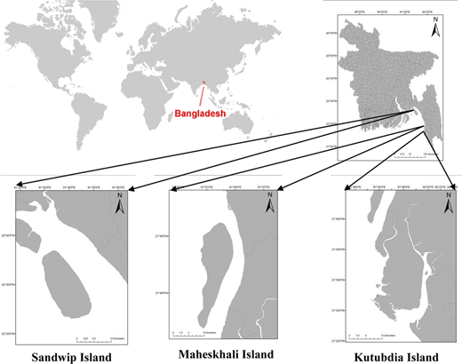
To conduct the study, the authors have selected the south-eastern coastal zone of Bangladesh, particularly three islands, namely, Maheskhali, Kutubdia and Sandwip. Climate susceptibility, displacement rates, land erosion and recurrent disaster have been considered during the selection for the study. The Sandwip Island belongs to Chittagong district with an area of 762.42 km2. Kutubdia Island belongs to Cox’s Bazar district with an area of 215.8 km2, which is bounded by the Bay of Bengal. Maheskhali Island is another coastal island belonging to Cox’s Bazar district with an area of 362.18 km2 that is also bounded by the Bay of Bengal. Three islands are created by tidal, supra-tidal and fluvial processes of Ganges river, particularly topography is mudflat, sandy and gentle slope (Figure 1).
2.2 Data collection
Basically, the study is primary or field data-based, but some of the secondary data have been used. Primary and secondary data sources have been used for the study. Primary data were collected through participant observation, key informant interview (KII), focus group discussion and questionnaire methods. Besides, in total, 385 questionnaires were operated in three islands (Table I).
Determination of sample size among three study areas
| Sample side | Total population (population census, 2011) (BBS, 2011) | Sample size |
|---|---|---|
| Sandwip Island | 279,000 | 148 |
| Kutubdia Island | 125,000 | 67 |
| Maheskhali Island | 321,000 | 170 |
| Total | 725,000 | 385 |
The sample size was selected with the help of a statistical representative formula (Islam, 2014) such as:
where n0 = desire sample size; z = standard normal deviate usually set at 1.96, which corresponds to the 95 per cent confidence level (z = 1.96); p = assumes proportion in the target population estimated to have a particular characteristic (p = 0.5); q = proportion of the estimation of population (q = 1-p); and d = allowable maximum error in estimating a population proportion (d = 0.05).
Moreover, the simple random sampling technique was adopted for successfully operating 385 questionnaires at a household level of the displaced people (Table I). Considering the representative sample size, the authors have distributed those samples on the statistical way with the help of the following formula:
where,
Nj = the sample size;
N = total population size;
(N = ni + nii + niii +……+ nn);
Ni = population size of study area; and
n = desired sample size.
2.3 Hazard ranking for displacement
After the climate change-induced hazards responsible for displacement were identified for the study areas, the hazards were ranked to describe their probability of occurrence and their impact on population, property and the economy. The probability of occurrence is an estimate of how often a natural hazard happens, with each hazard of concern being responsible for displacement rated in accordance with the numerical ratings. Estimates of risk for the study area were developed using methodologies promoted by FEMA’s hazard mitigation planning guidance and generated by FEMA’s HAZUS-MH risk assessment tool (FEMA, 2004).
2.4 Hazard impact analysis
The impact of each hazard can be considered in three categories: impact on the population, impact on the property (general building stock including critical facilities) and impact on the economy. In addition, a weighting factor is allocated to each impact category: three for the population, two for the property and one for the economy. This gives the impact on population, the greatest weight in evaluating the impact of a hazard (FEMA, 2004).
2.5 Risk ranking value
The risk ranking for each hazard is then calculated by multiplying the numerical value for the probability of occurrence by the sum of the numerical values for impact. Based on the total for each hazard, a priority ranking is assigned to each hazard of concern (high, medium or low) (FEMA, 2004).
2.6 Estimation of displaced people
For estimation of climate-displaced people of Kutubdia, Sandwip and Maheskhali islands, the authors followed the method of Schrepfer and Caterina (2014), which discussed the relationship between resilience and displacement, and propose this formula to understand how displacement and resilience are interconnected:
2.7 Weight scale for satisfaction level of displaced people
Authors applied Likert scales method (Vagias, 2006) for assess the satisfaction level of displaced people in present and past living condition. With the support of Likert scale method, comparative scenario of displaced people’s livelihood scenario and living status between before and after displacement have been found.
The authors have given the weight ranking of present and past living condition (Family income, occupation, housing condition, ownership of house, source of drinking water, sanitation facilities, health care facilities, women security, social security and coping ability with natural disaster) according to the statement of respondents. Weight ranking are categorized into 3 satisfaction level such as Strongly Dissatisfied Below 3, Neutral 3.00 and Strongly Satisfied Above 3.
2.8 Sustainable adaptation analysis
The question then arises as to what characteristics or conditions should be looked for when assessing adaptation responses? How can the concept of sustainable adaptation be realized? Four main principles are presented here for measuring the sustainable adaptation in the response to climate change and illustrating how adaptation can be formulated in different contexts. The key principles are:
recognize the context for vulnerability, including multiple stressors;
acknowledge that different values and interests affect adaptation outcomes;
integrate local knowledge into adaptation responses; and
consider potential feedbacks between local and global processes (Eriksen et al., 2011).
To dissect the adaptation effectiveness of the disaster-affected coastal zone, sustainable adaptation principles have been considered along with a set of criteria with a scale to rank them. IPCC finalized 11 criteria for adaptation measures from the four principles of sustainable adaptation, which are:
effectiveness for potential mitigation;
implement ability for the present need;
feasibility;
relevance to vulnerable community;
suitability for future climate scenarios;
applicability to multiple sectors;
economic viability;
local people participation;
environmental friendliness;
ecosystem connectivity; and
cultural acceptability (IPCC, 2001).
The criteria of adaptation are rated using the scale of low, medium and high. The scale is for the adaptation measures adopted by the Common Vulnerability Scoring System (CVSS), Version 3. This scoring system consists of three metric groups: base, temporal and environmental. The numerical formulas were updated to incorporate the new metrics while retaining the existing scoring range of 0-10. Textual severity ratings of none (0), low (0.1-3.9), medium (4.0-6.9), high (7.0-8.9) and critical (9.0-10.0) were defined (CVSS-SIG, 2015). Local people were asked to state their preference and give score about the ecosystem and community-based adaptation activities by the government organizations (GOs), nongovernment organizations (NGOs) and programs in the study areas. Total number of respondents was 385, who express their perception regarding the adaptation programs taken by GOs.
2.9 Data analysis
After collections of both qualitative and quantitative data from primary and secondary sources, these data were edited, coded, classified and tabulated in a sequential manner. Qualitative data were examined with the help of narrative analysis. Quantitative data were interpreted with the help of statistical and analytical analyses. Statistical and analytical analyses were done by the help of Statistical Package for the Social Science (SPSS: version-16) and various statistical techniques.
3. Results and discussion
3.1 Climate change-induced disaster scenario
It is the general scenario that coastal populations of Bangladesh are being displaced owing to the large-scale erosion of coast and river. A maximum number of poor people do not have land and home; they only have a small piece of land to build a cottage to live in. Once the home is eroded into the sea, they become homeless and become displaced persons in their home country (Hutton and Haque, 2003). According to the disaster history in the island areas and inhabitants respondents about the disaster probability, identified hazards were ranked in the following table which all are responsible for climate displacement in the study areas. Based on the combined risk values for the probability of occurrence and impact on Sandwip, Maheskhali and Kutubdia islands, a priority ranking of “high”, “medium” or “low” risk was assigned. The hazard ranking for the three study areas are detailed in the subsequent tables that present the step-wise process for the ranking (Table II).
List of disasters occurring in the study areas and their probability
| Hazard of concern | Probability | Numeric value |
|---|---|---|
| Cyclone | Frequent | 3 |
| Tidal surge | Frequent | 3 |
| Flash and tidal flood | Frequent | 3 |
| Coastal erosion | Frequent | 3 |
| Heavy rainfall | Frequent | 3 |
| Saline water intrusion | Frequent | 3 |
| Thunderstorms | Frequent | 3 |
| Land slide | Frequent | 3 |
Table III illustrates that cyclones, tidal surges, flash and tidal floods, coastal erosion and heavy rainfall frequently occurred in the study areas, which accelerate the loss of settlement and property in the case of island dwellers.
Total impact rating of disasters on population, property and economy of the study areas
| Hazard of concern | Population | Property | Economy | |||||||
|---|---|---|---|---|---|---|---|---|---|---|
| Impact | Numeric value | Multiplied by weighting factors (3) | Impact | Numeric value | Multiplied by weighting factors (2) | Impact | Numeric value | Multiplied by weighting factors (1) | Total impact rating | |
| Cyclone | High | 3 | 3 × 3 = 9 | High | 3 | 3 × 3 = 9 | High | 3 | 3 × 3 = 9 | 27 |
| Tidal surge | High | 3 | 3 × 3 = 9 | Medium | 2 | 3 × 2 = 6 | High | 3 | 3 × 3 = 9 | 24 |
| Flash and tidal flood | High | 3 | 3 × 3 = 9 | Medium | 2 | 3 × 2 = 6 | Medium | 2 | 3 × 2= 6 | 21 |
| Coastal erosion | Medium | 2 | 3 × 2 = 6 | High | 2 | 3 × 2 = 6 | Medium | 2 | 3 × 2 = 6 | 18 |
| Heavy rainfall | Medium | 2 | 3 × 2 = 6 | Medium | 2 | 3 × 2 = 6 | Low | 1 | 3 × 1= 3 | 15 |
| Saline water intrusion | Medium | 3 | 3 × 2 = 6 | Low | 1 | 3 × 1= 3 | Low | 1 | 3 × 1= 3 | 12 |
| Thunderstorms | Low | 1 | 3 × 1 = 3 | Low | 1 | 3 × 1 = 3 | Low | 1 | 3 × 1 = 3 | 12 |
| Land slide | Low | 1 | 3 × 1 = 3 | Low | 1 | 3 × 1 = 3 | Low | 1 | 3 × 1 = 3 | 9 |
Cyclone is the major devastating and climate change-induced disaster in island areas. Its severity and magnitude are recorded very high but duration was short. Table III shows the impact evaluation results for each hazard of concern, including the impact on property, infrastructure and the economy, which affected the communities of the study areas.
Inhabitants of the study areas argued that cyclones, tidal surges, tidal floods, coastal erosion, heavy rainfall, saline water intrusion, thunderstorms and landslides frequently occurred in the island areas in the south-eastern region of Bangladesh (Table IV).
Total ranking value for each disaster that occurred in the study areas
| Hazards | Probability | Impact | Total = (probability × impact) |
|---|---|---|---|
| Cyclone | Frequent | 27 | 81 |
| Tidal surge | Frequent | 24 | 72 |
| Flash and tidal flood | Frequent | 21 | 63 |
| Coastal erosion | Frequent | 18 | 54 |
| Heavy rainfall | Frequent | 15 | 45 |
| Saline water intrusion | Frequent | 12 | 36 |
| Thunderstorms | Frequent | 12 | 36 |
| Land slide | Frequent | 9 | 27 |
Table V explores that the highest risk value of 81 was found for cyclones and the lowest value of 27 was found for landslides, which only occurred in the Maheskhali Island. After the ranking of each natural disaster outbreak, the authors prepared the hazard ranking category by jurisdiction assigned for each hazard of concern in the study areas. The ranking categories were determined by an evaluation of the total risk ranking score into three categories: low, medium and high (Table V).
Summary of overall ranking of natural hazards by jurisdiction
| Area | Cyclone | Tidal surge | Flash and tidal flood | Coastal erosion | Heavy rainfall | Saline water intrusion | Thunderstorm | Landslide/Mud flow |
|---|---|---|---|---|---|---|---|---|
| Sandwip | High | High | Low | High | Medium | Medium | Low | Low |
| Kutubdia | High | High | Low | High | Medium | High | Low | Low |
| Maheskhali | High | High | High | High | High | High | Low | Medium |
3.1.1 Disaster history in the entire areas of south-eastern Bangladesh since 1960 to 2015.
From the historical data, it was found that cyclonic storm surge causes huge life and property losses for the people of Kutubdia, Sandwip and Maheskhali islands. The numbers of displaced people mentioned in the table are induced by cyclone and storm surges from 1960 to 2016. There has been an outbreak of 30 cyclones in the Bay of Bengal, which has caused significant damages to lives and properties in the study areas (Table VI). The cyclone occurrence data from 1960 to 2016 found that 574,000 inhabitants of south-eastern coast of Bangladesh were forced to be displaced from their home and land.
List of major cyclonic storm’s heat in south-eastern coast from 1960 to 2015
| Date of occurrence | Nature of phenomenon | Maximum wind speed in km/hr. | Tidal surge height in ft. | Death | People displaced |
|---|---|---|---|---|---|
| 11.10.60 | Severe cyclonic storm | 160 | 15 | 3,000 | 15,000 |
| 31.10.60 | Severe cyclonic storm | 193 | 20 | 10,000 | 50,000 |
| 30.05.61 | Severe cyclonic storm | 160 | 6-15 | 1,000 | 15,000 |
| 28.05.63 | Severe cyclonic storm | 209 | 8-12 | 11,520 | 70,000 |
| 05.11.65 | Severe cyclonic storm | 160 | 8-12 | 200 | 55,000 |
| 15.12.65 | Severe cyclonic storm | 210 | 8-10 | 875 | 80,000 |
| 01.11.66 | Severe cyclonic storm | 140 | 20-22 | 1,000 | 7,000 |
| 12.11.70 | Severe cyclonic storm with a core of hurricane wind | 224 | 10-33 | 100,000 | 250,000 |
| 28.11.74 | Severe cyclonic storm | 163 | 9-17 | 200 | 35,000 |
| 15.10.83 | Cyclonic storm | 93 | 3 | 50 | 5,000 |
| 09.11.83 | Severe cyclonic storm | 136 | 5 | 300 | 15,000 |
| 24.05.85 | Severe cyclonic storm | 154 | 15 | 12,000 | 45,000 |
| 18.12.90 | Cyclonic storm (crossed as a depression) | 115 | 5-7 | 400 | 20,000 |
| 29.04.91 | Severe cyclonic storm with a core of hurricane wind | 225 | 12-22 | 150,000 | 450,000 |
| 02.05.94 | Severe cyclonic storm with a core of hurricane wind | 278 | 5-6 | 400 | 15,000 |
| 25.11.95 | Severe cyclonic storm | 140 | 10 | 650 | 30,000 |
| 19.05.97 | Severe cyclonic storm with a core of hurricane wind | 232 | 15 | 150 | 15,000 |
| 27.09.97 | Severe cyclonic storm with a core of hurricane wind | 150 | 10-15 | 30 | 12,000 |
| 20.05.98 | Severe cyclonic storm with core of hurricane winds | 173 | 3 | 45 | 20,000 |
| 16.05.13 | Cyclonic storm (MAHASEN) | 100 | 5 | 25 | 70,000 |
| 30.07.15 | Cyclonic storm (KOMEN) | 65 | 5-7 | 132 | 120,000 |
| 21.05.16 | Cyclonic storm (Ruano) | 100 | 7-8 | 25 | 200,000 |
3.1.2 Number of climate-displaced people in south-eastern coastal belt of Bangladesh since 1980-2016.
Devastating cyclones, increasing tidal levels and continued erosion, hazardous transportation system and lack of modern utility services like power, healthcare and safe drinking water have turned the lives of the coastal community in the island areas into misery. Ciavola et al. (2015) estimated that at least 22 per cent out of the total population of Sandwip Island were forced to migrate to safer places in Chittagong city and other parts of the country, as their homesteads were destroyed following unabated erosion. Many former residents of Kutubdia Island left their ancestral homes for a variety of climate-related reasons, and about 50,000 displaced peoples have been living in Cox’s Bazar city, located 75 km south of Kutubdia, to escape land erosion, floods, cyclones, storm surges and a rise in sea level (Islam et al., 2012). Island dwellers claimed that unwilling migration takes place as a last resort to cope with the impacts of disasters. In the study, it was found that 370,000 people of Kutubdia, Maheskhali and Sandwip islands have experienced displacement in their living places within 36 years (1980-2016) owing to disasters such as cyclones, coastal erosion, tidal floods and water logging (Table VII).
Climate-displaced peoples of south-eastern Bangladesh coastal area (1980-2016)
| District | Upazila | Reason of displacement | No. displaced peoples | Destination |
|---|---|---|---|---|
| Chittagong | Sandwip | Cyclone, erosion, tidal inundation and water logging | 130,000 | Chittagong and Cox’s Bazar |
| Cox’s Bazar | Maheskhali | Cyclone, erosion, tidal inundation and sudden flood | 90,000 | Cox’s Bazar |
| Kutubdia | Cyclone, erosion, tidal inundation, sudden flood and water logging | 150,000 | Cox’s Bazar | |
| Total | 370,000 | |||
3.2 Comparison of displaced people’s livelihood before and after displacement situation
Climate change and population displacement were directly linked with each other. Climate change possesses significant risks for Bangladesh, especially for the coastal community. The societal exposure to such risks is further enhanced by Bangladesh’s high population and population density. During the disaster period, people temporarily go to the safe zones and usually return after the disaster. But such may not be the case every time. Sometimes, people’s homes and homestead areas are damaged in the disasters. As a result, they are permanently displaced from their original place, which is a common scenario in the islands. They often have to start everything from scratch in the new place, such as shelter, environment, livelihood and lifestyle, which put them in the challenging situation. Climate-displaced people of the study islands were strongly dissatisfied on the present status of family income level, occupation, housing status and ownership, health-care facilities, security of women and coping ability with natural disasters when compared with their earlier living places (Table VIII).
Satisfaction level of displaced communities of islands
| Livelihood indicators | Level of satisfaction | Weight analysis | ||||||
|---|---|---|---|---|---|---|---|---|
| 5 | 4 | 3 | 2 | 1 | Total calculation | Weight | Remarks | |
| Sandwip Island | ||||||||
| Family income | 10 | 30 | 45 | 55 | 8 | 420 | 2.837 | Strongly dissatisfied |
| Occupation | 5 | 28 | 40 | 70 | 5 | 402 | 2.716 | Strongly dissatisfied |
| Housing condition | 3 | 12 | 20 | 100 | 13 | 336 | 2.270 | Strongly dissatisfied |
| Ownership of house | 5 | 6 | 8 | 120 | 11 | 324 | 2.189 | Strongly dissatisfied |
| Source of drinking water | 50 | 90 | 5 | 3 | 0 | 631 | 4.263 | Strongly satisfied |
| Sanitation facilities | 30 | 50 | 10 | 35 | 23 | 473 | 3.195 | Strongly satisfied |
| Health care facilities | 10 | 28 | 22 | 80 | 8 | 396 | 2.675 | Strongly dissatisfied |
| Women security | 5 | 7 | 10 | 96 | 30 | 305 | 2.060 | Strongly dissatisfied |
| Social security | 4 | 7 | 9 | 90 | 38 | 293 | 1.979 | Strongly dissatisfied |
| Coping ability with natural disaster | 4 | 6 | 8 | 105 | 25 | 311 | 2.101 | Strongly dissatisfied |
| Kutubdia Island | ||||||||
| Family income | 7 | 18 | 8 | 28 | 6 | 193 | 2.880 | Strongly dissatisfied |
| Occupation | 3 | 8 | 10 | 40 | 6 | 163 | 2.432 | Strongly dissatisfied |
| Housing condition | 0 | 2 | 4 | 60 | 1 | 141 | 2.104 | Strongly dissatisfied |
| Ownership of house | 0 | 1 | 3 | 50 | 13 | 126 | 1.880 | Strongly dissatisfied |
| Source of drinking water | 10 | 30 | 5 | 15 | 7 | 222 | 3.313 | Strongly satisfied |
| Sanitation facilities | 8 | 25 | 20 | 10 | 4 | 224 | 3.34 | Strongly satisfied |
| Health care facilities | 3 | 8 | 10 | 50 | 6 | 183 | 2.731 | Strongly dissatisfied |
| Women security | 00 | 00 | 8 | 50 | 9 | 133 | 1.985 | Strongly dissatisfied |
| Social security | 2 | 5 | 7 | 45 | 8 | 149 | 2.223 | Strongly dissatisfied |
| Coping ability with natural disaster | 00 | 00 | 5 | 42 | 20 | 119 | 1.776 | Strongly dissatisfied |
| Maheskhali Island | ||||||||
| Family income | 3 | 20 | 24 | 95 | 28 | 385 | 2.264 | Strongly dissatisfied |
| Occupation | 00 | 8 | 12 | 145 | 2 | 360 | 2.117 | Strongly dissatisfied |
| Housing condition | 00 | 10 | 15 | 90 | 55 | 320 | 1.882 | Strongly dissatisfied |
| Ownership of house | 2 | 5 | 7 | 115 | 41 | 322 | 1.894 | Strongly dissatisfied |
| Source of drinking water | 8 | 70 | 50 | 35 | 4 | 544 | 3.20 | Strongly satisfied |
| Sanitation facilities | 10 | 50 | 70 | 20 | 20 | 520 | 3.05 | Strongly satisfied |
| Health care facilities | 20 | 35 | 40 | 65 | 10 | 500 | 2.941 | Strongly dissatisfied |
| Women security | 3 | 6 | 13 | 96 | 52 | 322 | 1.894 | Strongly dissatisfied |
| Social security | 5 | 8 | 12 | 120 | 21 | 354 | 2. 082 | Strongly dissatisfied |
| Coping ability with natural disaster | 00 | 5 | 7 | 40 | 108 | 229 | 1.347 | Strongly dissatisfied |
Although a positive change was noticed in the income level of displaced people from the pre- to post-displacement areas, their satisfaction level remained low when compared to the pre-displacement situation. Moreover, the monthly income increased with family expenditure but was too insufficient to meet the demands of the family. Moreover, in the current location, displaced people faced various types of difficulties, particularly high living cost, lack of employment opportunity, insecure life, environmental threats, an absence of the social bonding and physiological stress. On the one hand, before displacement, the villagers were insecure from events of natural disaster, while in the post-displacement situation (at Cox’s Bazar and Chittagong areas), the displaced people still faced insecurity owing to the identity crisis, local political harassment and violence of local muscle man and so on. Displaced people were strongly satisfied with status and quality of drinking water and sanitation level at places they lived at present when compared with their previous homes. This happened because GOs and NGOs working in islands and hard-to-reach areas ensured water and sanitation facilities for all the people.
3.3 Sustainable adaptation to resolve climate displacement
The coastal communities are the most vulnerable victims because of the absence of social and physical security along with the arrogant nature of the climate. (Salauddin and Ashikuzzaman, 2012). Groups that need to be considered may be the fishing families, who will be affected by changes in freshwater and marine ecosystems, and poor and marginal farmers, who will be at greater risk from crop failure than better-off farmers and will need special attention to protect them from income losses owing to climate change and, finally, large scale displacement of people. They proposed adaptation options like insurance against climate-related losses may also be an effective risk reduction mechanism for reducing the climate change-induced displacement effect.
For the successful adaptation to resolve the climate displacement problem, the government should enter into a partnership with the insurance industry and NGOs to develop new insurance products for the people, households and enterprises. The government, however, acts to protect the huge coastal resources and community from the extreme effects of climate change. However, there is an evidence of deficiency of accord that is about the successful adaptation, opening at the global level and having rippling effects downwards. Finally, successful climate change adaptation will be seen on multi-decadal time frames based on the accomplishment of alteration objectives erogenous to a changing climate. However, it appears discreet to demand that assessing of climate change adaptation at all scales should include elements of effectiveness, flexibility, efficiency, equality and sustainability (IDS, 2008).
Starting the debate on the option of sustainable adaptation for resolving the climate displacement problem and human security means that the insecurity of the households is embedded in a broad spectrum of power relations that condition the households’ livelihoods. Climate change-induced displacement is not a condition of the future, but it is something that has already started in many countries like Bangladesh. Although eight types of climate-induced disasters have been occurring in the study areas, but cyclones/storm surges and coastal bank erosion are the most significant and recurrent in nature in the study areas. A person’s life and livelihood are more vulnerable in the coastal area. After displacement, people of Kutubdia, Maheskhali and Sandwip areas move to different places like Cox’s Bazar, Chittagong city and nearby hill area. They generally take shelters in the embankment with the hope of relief that has been provided by the government and different organizations. The local residents of Sandwip, Maheskhali and Kutubdia islands have been trying to protect themselves since people started to live here. The study results revealed that most of the adaptation strategies of the households were autonomous. It has also been found that households have individually been trying to adopt very traditional and manual methods. However, the households also act as a group being led by the social leader, while simultaneously requesting for government assistance so that they can cope with the climate change vulnerabilities. Their action may be considered as one type of collective adaptation methods.
The major environmental and climate change-sensitive policy issues the southwest Bangladesh are an affiliated sustenance of natural processes that are nourishing the regional ecosystems and that guarantee the sustainable supply of natural resources on which the population survives. The plight of the southwest community deserves its right in case of traditional water management, rainwater harvesting, an environment-friendly transport system, liberating water flow, the ecologically vibrant Sundarbans, judicious groundwater management, concern for forced climate-displaced population, environment-friendly industrial growth and application of disaster risk reduction in policy documents. Besides, alternative livelihood opportunity for the coastal communities is a prerequisite to combat climate displacement from south-western Bangladesh (Roy, 2017). As the poor live in the coastal belts, they are the most vulnerable and the prime victims of the detrimental effects of climate change. The road infrastructure, power, housing, sanitation, transportation and coastal protection are poor in the study areas Kutubdia, Maheskhali and Sandwip islands. The rural islanders build their houses with locally available woodcraft, artesian using wood, bamboo, CI sheet (tin) and other thatching materials. The areas under the coverage of mangrove afforestation located in the front of the coastal embankment in the study areas are now free of coastal erosion, and people consider these adaptation options to be better for preventing the displacement risk from their living place. However, coastal plantations are mostly under tremendous threats owing to illegal grazing, illicit tree felling and forest land encroachment led by influential people, which tends to lead to serious damage to plantations (Siddiqi, 2001). Inhabitants of the study areas destroy the mangrove forests because of increase salt and shrimp farming area for financial solvency. As a result of the natural disasters occurring in the Kutubdia, Sandwip and Maheskhali islands, high levels of tidal and storm surges easily destroy the weak embankment and flood the community living places and uproot the houses.
The study reveals that major portions of the Kutubdia, Sandwip and Maheskhali islands are exposed to the open sea and are being influenced by the strong wave actions as well as seasonal cyclones, sea level rise and de-sedimentation, which eventually accelerated erosion. However, the effect of long shore currents cannot be overlooked. Kazi et al. (2015) suggested for salinity-resistant plantation and a green belt around the embankment in the coastal area of Bangladesh for protecting the people from displacement owing to climate change-induced natural disaster. During the study, it has been found that the Bangladesh Forest Department planted salinity-resistant trees around the island. Besides, experts during the KIIs suggested for taking the initiative to develop uninterrupted coastal afforestation including embankment by salinity-resistant and indigenous species (Table IX).
Plantation of saline-resistant trees and trees for green belt at coastal area of Bangladesh as an adaptation option from erosion
| Local name | Scientific name | Family | Habit |
|---|---|---|---|
| Salinity-resistant trees | |||
| Sundari | Heritiera fomes | Sterculiacede | Big or large tree |
| Keroa | Sonneratia apetala | Sonneratiaceae | Small tree |
| Narikel (coconut) | Cocos nucifera | Palmae | Tree |
| Babla | Acacia nilotica | Leguminosae | Medium tree |
| Sisu | Dalbergia sissoo | Leguminosae | Medium tree |
| Kakra | Bruguiera sexangula | Rhizophoraceae | Medium tree |
| Keroa Babla | Pithocellobium dulce | Leguminosae | Tree |
| Trees for green belt at coastal area | |||
| Hijal | Barringtonia acutangula | Myrtaceae | Medium tree |
| Supari | Areca catechu | Palmae | Large tree |
| Khajur | Phoenix dactylifera | Palmae | Medium tree |
| Tetul | Tamarindus indica | Leguminosae | Big or large tree |
| Bans | Bambusa spp. | Graminae | Medium tree |
| Silkoroi | Albizia procera Benth. | Leguminosae | Medium tree |
The commercially important trees around the homestead have been planted by the coastal island dwellers. They have also built the houses that are short in height and also have increased the ground level of the houses. This adaptation option by the island dwellers is ranked in the high categories. Moreover, owing to the environmental, economical and social perspectives, these practices have become a sustainable and successful adaptation for the respondents. These adaptation practices attempt to reduce the displacement risk of damage owing to storm surges and coastal erosion for the households. People also earn money by selling the products of the trees, from which they are economically benefited. From the study, it has been found that the Government of Bangladesh rehabilitated climate-displaced people in these islands through the distribution of agriculture khas land and housing in Ashrayan and Abasan projects. However, the numbers of rehabilitated peoples in these islands were so nominal when compared with the number of displaced people from the study areas. According to the ranking of respondents of the study areas, adaptation options of khas land distribution to climate-displaced persons were set up in the medium-ranked position. This adaptation process will be sustainable in the study areas if the distribution process is completed within the short period and proper beneficiaries are selected. The Ashrayan and Abasan projects are the housing-related rehabilitation programs by the government, where displaced people are living free of cost. However, the Ashrayan and Abasan projects of Kutubdia, Maheskhali and Sandwip islands are gradually being forsaken, as cracks have started to show up in both the kutcha and pucca houses, making them unsuitable for living, and also owing to the lack of monitoring by the respective departments. It has been observed in the study that four Ashrayan project inhabitants in Maheskhali and Kutubdia were living with the threat of coastal erosion. Respondents demanded more activities of the Ashrayan and Abasan projects in the study areas for rehabilitation of climate-displaced people, as they frequently become landless and homeless (Table X).
Rehabilitation of climate-displaced people in the study areas
| Islands | Khas land | Ashrayan/Abasan project | Cyclone shelter/Shelter home | Rehabilitated people permanently |
|---|---|---|---|---|
| Maheskhali | 1,302 acres (1,170 acres distribute) | 04 | 95 | 1,100 |
| Kutubdia | 2,345 acres (1,200 acres distribute) | 06 | 76 | 1,300 |
| Sandwip | 10,543 acres (3,450 acres distribute) | 03 | 20 | 2,000 |
Island dwellers of the three islands always experienced displacement owing to damage of coastal embankment. The main causes of embankment failure are:
erosion owing to rain splash, wave action and overtopping of storm surge;
overturning or uprooting of trees during the cyclone;
inaccuracy in the construction of side slope of embankment (also enhances embankment failure); and
poor maintenance practice.
A special grass, vetiver grass (Vetiveria zizanioides), is being used for slope protection to stop the erosion and for protecting the embankment in many parts of Bangladesh. This practice of grass plantation has been successfully implemented along river banks of different districts. This adaptation option has been found in the small part of coastal embankments in Sandwip and Maheskhali islands. Besides, vetiver grass (Vetiveria zizanioides) is found mostly at the household level for protecting from erosion. Respondents of the study area said that the households who used this sustainable adaptation practices around their homestead and nearby road managed to save their houses and assets from the recent cyclonic storm and tidal inundation. This was made possible because vetiver grass has certain qualities to minimize the storm runoff and protect the embankment without causing any harm to the embankment during the cyclone and tidal floods (Table XI).
The criteria of sustainable adaptation are rated using the scale of low, medium and high
| Adaptation practices | Evaluation Criteria | Ranking | ||||||||||
|---|---|---|---|---|---|---|---|---|---|---|---|---|
| Effectiveness for potential mitigation | Implement ability for the present need | Feasibility | Relevance to vulnerable community | Suitability for future climate scenarios | Applicability to multiple sectors | Economic viability | Local people participation | Environmental friendliness | Ecosystem connectivity | Cultural acceptability | ||
| Coastal afforestation on the slopes of embankment and roadside | 7 (High) | 6 (Medium) | 7 (High) | 8 (High) | 7 (High) | 7 (High) | 6 (High) | 8 (High) | 9 (High) | 9 (High) | 6 (Medium) | High |
| Plantation of commercial importance trees around the homestead | 7 (High) | 7 (High) | 6 (Medium) | 8 (High) | 7 (High) | 8 (High) | 7 (High) | 8 (High) | 8 (High) | 7 (High) | 7 (High) | High |
| Govt. agriculture Khas land distribution for rehabilitation of landless | 6 (Medium) | 7 (High) | 7 (High) | 7 (High) | 7 (High) | 7 (High) | 7 (High) | 6 (Medium) | 5 (Medium) | 5 (Medium) | 7 (High) | High |
| Vetiver grass (Vetiveria zizanioides) plantation in the slope of embankment and around the homestead | 7 (High) | 6 (Medium) | 8 (High) | 7 (High) | 6 (Medium) | 7 (High) | 7 (High) | 7 (High) | 5 (Medium) | 7 (High) | 7 (High) | High |
| Sluice gate constructed and maintenance for tidal water controlled | 8 (High) | 7 (High) | 6 (Medium) | 7 (High) | 6 (Medium) | 7 (High) | 5 (Medium) | 6 (Medium) | 6 (Medium) | 5 (Medium) | 6 (Medium) | Medium |
| Tying roof of house with veranda and mud walls with wooden pegs fixed to ground | 7 (High) | 6 (Medium) | 6 (Medium) | 6 (Medium) | 6 (Medium) | 6 (Medium) | 5 (Medium) | 7 (High) | 7 (High) | 5 (Medium) | 7 (High) | Medium |
| Tying roof to mud walls of house | 7 (High) | 6 (Medium) | 6 (Medium) | 6 (Medium) | 6 (Medium) | 6 (Medium) | 5 (Medium) | 7 (High) | 7 (High) | 5 (Medium) | 7 (High) | Medium |
| Short height house construction | 3 (Low) | 3 (Low | 5 (Medium) | 3 (Low) | 3 (Low) | 6 (Medium) | 3 (Low) | 3 (Low) | 6 (Medium) | 3 (Low) | 5 (Medium) | Low |
| Increase the heighten of dike along the houses | 8 (High) | 6 (Medium) | 7 (High) | 7 (High) | 7 (High) | 6 (Medium) | 5 (Medium) | 7 (High) | 6 (Medium) | 7 (High) | 7 (High) | High |
| Bamboo revetment or bundling of bamboos for erosion protection | 6 (Medium) | 6 (Medium) | 5 (Medium) | 7 (high) | 6 (Medium) | 6 (Medium) | 5 (High) | 7 (High) | 6 (Medium) | 5 (Medium) | 6 (Medium) | Medium |
| Concrete-pole breakwater system for protection from erosion | 6 (Medium) | 6 (Medium) | 5 (Medium) | 7 (High) | 6 (Medium) | 6 (Medium) | 5 (High) | 7 (High) | 7 (High) | 5 (Medium) | 6 (Medium) | Medium |
| Setting new poles diagonally around the house | 6 (Medium) | 6 (Medium) | 5 (Medium) | 6 (Medium) | 6 (Medium) | 3 (Low) | 5 (Medium) | 7 (High) | 6 (Medium) | 5 (Medium) | 7 (High) | Medium |
| Repairing of the shelters and building new shelters as per requirement | 3 (Low) | 3 (Low) | 4 (Medium) | 6 (Medium) | 3 (Low) | 4 (Medium) | 3 (Low) | 3 (Low) | 3 (Low) | 5 (Medium) | 5 (Medium) | Low |
| Develop the cluster village/Ashrayan/Abasan program | 8 (High) | 8 (High) | 6 (Medium) | 7 (Medium) | 6 (Medium) | 6 (Medium) | 5 (Medium) | 7 (High) | 6 (Medium) | 5 (Medium) | 7 (High) | Medium |
| Building houses on raised platform | 7 (High) | 7 (High) | 6 (Medium) | 6 (Medium) | 6 (Medium) | 6 (Medium) | 5 (Medium) | 7 (High) | 6 (Medium) | 5 (Medium) | 6 (Medium) | Medium |
| C.C block embankment set up for erosion protection and attraction for tourism | 7 (High) | 6 (Medium) | 5 (Medium) | 6 (High) | 6 (Medium) | 7 (High) | 5 (Medium) | 7 (High) | 7 (High) | 5 (Medium) | 7 (High) | High |
| Gathering foods and crops under the soil and safe place from the fields | 3 (Low) | 5 (Medium) | 3 (Low) | 3 (Low) | 3 (Low) | 3 (Low) | 5 (Medium) | 3 (Low) | 6 (Medium) | 5 (Medium) | 5 (Medium) | Low |
| Micro credit loan without or low interest from GO and NGO | 3 (Low) | 6 (Medium) | 3 (Low) | 6 (Medium) | 3 (Low) | 3 (Low) | 5 (Medium) | 3 (Low) | 5 (Medium) | 3 (Low) | 3 (Low) | Low |
| Production of short duration, salinity and flood tolerant crops, high productive year-round-based crops and vegetables in the crop field and homestead area | 7 (High) | 7 (High) | 5 (Medium) | 6 (Medium) | 6 (High) | 6 (High) | 5 (Medium) | 7 (High) | 6 (Medium) | 5 (Medium) | 7 (High) | High |
| Pond excavation and raising boundary of pond | 6 (Medium) | 7 (High) | 5 (Medium) | 6 (Medium) | 6 (Medium) | 7 (High) | 5 (Medium) | 6 (High) | 6 (Medium) | 6 (Medium) | 7 (High) | Medium |
| Valuable goods keep hanging with the roof and put ornaments under earth surface inside the homestead | 6 (Medium) | 6 (Medium) | 5 (Medium) | 6 (Medium) | 6 (Medium) | 6 (Medium) | 5 (Medium) | 7 (High) | 3 (Low) | 3 (Low) | 6 (Medium) | Medium |
| Small-scale fish farming and crab fattening in the excavated pond around the house | 6 (Medium) | 6 (Medium) | 5 (Medium) | 6 (Medium) | 6 (Medium) | 6 (Medium) | 5 (Medium) | 5 (Medium) | 6 (Medium) | 5 (Medium) | 6 (Medium) | Medium |
Table XI shows that local respondents gave the highest score to those government structural adaptation programs which were designed and implemented to reduce physical exposure of climate change-induced disasters and rehabilitation project of climate-displaced poor people. The ranking has been developed according to the sustainable adaptation criteria for resolving the climate displacement problem. In the case of NGOs, community based organizations (CBOs) and indigenous adaptation programs, respondents gave the highest score to those programs which have been designed and implemented to improve the socioeconomic condition of their lives.
Most of the island dwellers frequently complained that they might not survive very long if government agencies would not do anything for them. Some households have taken initiative for heightened off the dike, bamboo revetment and concrete-pole breakwater process for protect their house and land from coastal erosion. The function of such construction is to lessen the impact of waves and storms. The individual options cannot substitute others but rather support other options. Among these, heightening of the dike is the most popular adaptation option found in these islands. Respondents of the study areas told that dike heightening practices are used by the communities mostly for protecting houses from coastal erosion and tidal surges. Bamboo revetment has also been practiced in these islands along with damaged coastal embankment for protection from tidal flood and storm surges. However, the effectiveness of this practice has not proved to be efficient to protect the people from displacement. Sometimes this practice is effective and sometimes not. According to the respondents, concrete-pole breakwater system for adaptation options to protect the embankment from erosion and flood is noticed to be more effective than bamboo revetment in the study areas. However, there is a problem for the construction of concrete-pole breakwater practice in all parts of the study area because sometimes it is impossible to carry from another place to build the breakwater. For this reason, very few respondents of the study area agreed for this adaptation practice, and this is not a sustainable practice for adaptation.
To prevent the house roofs from being blown away by storms and other disasters, the communities of Sandwip, Maheskhali and Kutubdia islands practiced three techniques of community-based adaptation: tying roof to mud walls of house, tying roof of house with veranda and mud walls with wooden pegs fixed to ground and hanging weights from four corners of roof during cyclone season. All these adaptation practices can save the house roofs from moderate seasonal cyclone storms, their economic cost is insignificant and replication of these practices is desirable. These practices significantly reduce the risks of household asset loss and compared to other methods require relatively less preparation and time. Their replication is highly desirable.
The rehabilitation of coastal livelihoods after a natural disaster should be seen as an opportunity to strengthen and revitalize coastal communities for adaptation to resolve the displacement problem. The focus of rehabilitation efforts should be on rebuilding the economic basis of livelihoods rather than on physical reconstruction, and on giving coastal people, the skills and resources for self-recovery of the displacement problem and migration to other places. Both the public and private sectors need to be actively involved in livelihood rehabilitation efforts, seeking out and creating opportunities for both economic and social development.
4. Conclusion and recommendations
Bangladesh is one of the most vulnerable countries to climate change because of its population density, less amount of land area and low-lying topography dominated by major rivers that drain down the Himalayan mountains and foothills. Frequent floods caused by cyclones and seasonal rains lead to significant loss of life and property, and the most vulnerable communities are those marginalized rural groups who seek to make a living along the coastal embankment, thus leading to being displaced from their home and land. People living in these areas have relatively limited capacity to cope with climate-induced shocks, and consequently, natural disasters are likely to have persistent effects on their lives, livelihoods, health and welfare.
The study reveals that households have somewhat responded to the cyclone, tidal flood and coastal erosion hazards and other climate change issues through the adoption of a range of adaptation strategies depending on their socioeconomic and household characteristics, and access to institutional facilities and social capital. The important barriers to adopt the adaptation strategies include a lack of information about coastal erosion and related climatic issues, a lack of knowledge about appropriate strategies, unsuitable crop varieties, the limitations of one’s own land and limited access to credit. Sustainable adaptation is essentially a global issue, as social equality and environmental integrity are important for all populations to achieve sustainable responses to climate change. The adaptation processes have and will generate explicit consideration of the risks of the sea-level rise in the strategic planning processes of local governments throughout the Kutubdia, Maheskhali and Sandwip islands.
The following recommendations have been proposed based on the study findings and discussions through KII with experts, representatives of local government, government officials and research experiences of the authors. These recommendations will help to proper management of displacement issues, governance practices, Khas land distribution and rehabilitation programs in the island areas as well as the whole of Bangladesh:
Coastal embankment should be built or repaired by triangular concrete with the stone block and take initiative for coastal afforestation by mangrove or saline-resistant plant species alongside embankment and create a local joint monitoring team for monitoring the afforestation and embankment.
Climate change-induced disaster resilience should be invented, particularly on agricultural sectors (saline water and flood resistance crops species, conservation of good and healthy seed during harvesting) as well as livelihood opportunity for the displaced people.
The government should ensure eight rights of displaced people, mainly humanitarian assistance (emergency period), adequate housing and shelter, land, food, water and adequate sanitation, education for school children, health-care facilities, freedom of movement, choose their residential location and relocate.
To deal properly with this displacement issue, the government should develop and implement a nationwide climate displacement monitoring mechanism to monitor and record all displacements as a result of the climate change-induced disaster.
Relocation/rehabilitation program should be an effective, transparent and just program from the selection to allocation of housing and land to the displaced people. The government should ensure that all the persons selected are free and fair and no political and illegal influences are there.
The findings of this study have assisted in formulating effective policies and programs to improve and sustain the site-specific coping and adaptation strategies for the islands as well as coastal communities in Bangladesh, and thus assist with incorporating these strategies into the wider climate change policies.

