
In July, the British Dam Society was invited to a presentation and tour of the construction site at Enfield Golf Course flood storage reservoir, north London. The reservoir forms part of the Salmons Brook Flood Alleviation Scheme with the Environment Agency as client, Halcrow (now CH2M Hill) as designer and Volker Stevin as contractor.
1. Salmons Brook scheme
This scheme will reduce flood risk to 1393 properties in Enfield and Edmonton where the Salmons Brook and Saddlers Brook streams flow towards the River Lea. The concept was initially developed after October 2000 when 192 properties around Montagu Road in Edmonton flooded. Up to 727 of the properties benefiting from the scheme will be protected from 1 in 75 chance floods whereas the remainder will benefit from at least a 1 in 35 standard of protection. Around 800 properties are in one of London's most deprived areas (some houses were still recovering from the floods that occurred in 2000 some 9 years later) and so the works will greatly benefit them. The pre-scheme standard of protection was around 1 in 20 and the floods of 2000 were estimated to have 1 in 30 probability.
The scheme is to create two flood storage reservoirs (FSRs), raising of flood walls, culvert construction to increase flow capacity under Montagu Road and installation of penstocks to divert flood waters away from a high flood risk area. Through working with the London Borough of Enfield, there will also be improvements to wildlife habitats (with a net improvement to Water Framework Directive objectives for the watercourse), wheelchair access and cycle paths. The Enfield FSR in the upper catchment will reduce flood flows and delay the rural flood peak. Raised defences and the second FSR, at Montagu Recreation Ground, will contain the flood water within open spaces, while flood flow diversions and increased culvert capacity will allow greater flood events to pass the areas at risk. The current forecast cost is £15ṡ3 million and the scheme has a design life of 100 years.
Presentations and the tour were given by John Gosden (construction engineer, Jacobs), Jon Holland (ECC project manager, CH2M Hill), Mike Gara (project manager, Environment Agency (EA)), Steve Whipp (senior user, EA), Bob Hall (ECC supervisor), Ruth Snowden (graduate site engineer, Volker Stevin (VS)) and Siobhán Gleeson (graduate engineer, EA – seconded to VS).
2. Enfield Golf Course FSR
During the British Dam Society visit we were familiarised with the upper catchment FSR, which will store flood water on the floodplain areas of Enfield Golf Course. Salmons Brook – which runs through the course – is fed by a 14 km2 catchment and, when completed, the reservoir will store up to 134 000 m3 of flood water during 1 in 100 chance flood events.
A compensation package for temporary disruption owing to additional flooding is being agreed with the golf club business and landowner. This includes the installation of fin drains in the lower fairways, which already suffer from surface water and flooding issues. Once full and the event has passed, the reservoir will empty in around 20 h and so these drains will also help return the field to playable conditions more quickly by aiding surface and soil drainage.
Years of regular consultation with the public were required to gain planning consent for the scheme. The works are mainly providing a flood risk benefit to properties further downstream in Edmonton and so a gradual approach was required to portray the benefit for public access and wildlife in the immediate area. Access to the site was gained through a family-orientated residential area and some works were in close proximity to housing. This resulted in planning conditions on HGV movements to prevent interference with school runs.
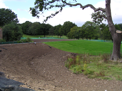
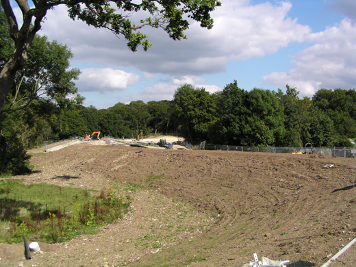
The homogeneous clay embankment is approximately 350 m long across the floodplain (mostly within Cheyne Walk Open Space and partly on the golf course) and rises up to 2ṡ5 m above the surrounding ground level (see Figure 1 and Figure 2). It was designed to blend in well with the surrounding landscape, maintain golf playability upstream of the embankment and minimise tree removal. During construction, a global positioning system-enabled dumper truck was used to aid correct laying of clay for the embankment. This greatly reduced the labour hours required in setting out and checking the constructed form of the embankment. The spillway is 102 m long and will be reinforced with Grasscrete to resist the probable maximum flood flow of 106 m3/s, while providing a grass cover appearance.
A 22 m long × 4 m high flume with cantilevered sheet pile walls has been installed in the embankment to control flow (Figure 3). Piles of up to 11 m in length were used and clad with bricks and mortar to improve the flume's appearance. The bridge above it was designed to the Highway Agency standards and can transfer 26 t vehicles, allowing a grab lorry to sit on top and remove large debris if necessary. A trash screen has not been provided as the upstream channel has many low bridges on which any large debris is likely to be caught. This flume will create a pinch point for the river flow during 1 in 1 chance events, for which the golf course previously experienced flooding and the 2ṡ5 m wide × 1ṡ5 m high orifice will cause further impoundment during 1 in 5 chance events and greater.
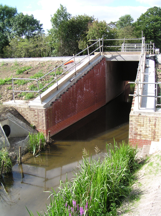
Due to the current land use of the site and built-up nature of the surrounding land, it was not possible to find the 9000 m3 of cohesive clay required locally and so it was imported from a quarry near Stansted Airport. To balance the environmental impact of the project, the majority of trees that were felled are being replaced elsewhere in the scheme. This passive structure will also have telemetry to record impoundment events and warn of blockages to it, thus it will require neither frequent monitoring nor maintenance visits – reducing the operational resource requirements of the structure over its lifetime. The flume bed was roughened to improve silt capture and encourage invertebrate habitats – on the day of our visit there was already some vegetation in the channel transitions leading into the flume and a red-billed coot had made its nest among the reeds.
Before construction is completed, cycle and footpaths will be placed over the embankment to reinstate access to and through Cheyne Walk Open Space, and the areas that were used for stock piling and site offices, will be returned to a wildflower meadow.
On behalf of those who attended the event, I would like to thank all everyone who took the time to give us an understanding of the project and a tour of the site. As climate change progresses, there will be an increasing need for green spaces in towns and cities to adapt and be used for flood storage purposes. This visit provided an insight into the long process of developing the public's understanding and encouraging their support for such projects. It has also highlighted the challenges faced by engineers when site locations and available space impose tight design and construction restrictions.
