The devastating impact of catastrophic disasters on terrestrial infrastructure requires the adoption of alternative technology solutions among humanitarian organizations. The purpose of this paper is to analyze the role of the most commonly used satellite technologies in relief logistics: imagery and mapping, portable global positioning system (GPS) positioning devices, telecommunications, and GPS vehicle tracking.
The paper examines both the benefits and limitations of satellite technologies in light of the existing literature and through a complementary questionnaire survey with field workers involved in humanitarian operations in the aftermath of the 2010 Haiti earthquake.
The results show that the use of satellite technologies can facilitate most of the key logistics challenges encountered by relief actors. However, they also highlight important barriers within humanitarian organizations such as the lack of skilled workers and high costs, underlining the need for long-term training, resource investments, and cooperation between users and technology providers.
The research findings remain valid only in the context of catastrophic disaster responses, which lead to similar destructions, logistical problems, and needs for satellite technologies.
This paper shows how satellite technologies can support humanitarian professionals in the field. It also provides policy recommendations that can facilitate the use of these technologies.
The applications of satellite technologies within humanitarian supply chains are not well-defined in the literature. This paper is the first to be dedicated to analyze the role of the main satellite technologies used in a relief logistics setting.
1. Introduction
The flexible and timely deployment of relief organizations is crucial for saving lives in the immediate aftermath of a sudden-onset catastrophic disaster (Holguín-Veras et al., 2012). In particular, logistics is the most essential function for providing vital aid, such as water and food supplies (Howden, 2009). However, the physical destruction and chaotic settings induced by large-scale disasters limit assessment and response capacities, and increase coordination difficulties (Holguín-Veras et al., 2012; Howden, 2009; Van Wassenhove and Pedraza Martinez, 2012). Therefore, acquiring accurate information regarding the ground situation is crucial to evaluate the disaster’s impacts and manage emergency operations. To this end, relief organizations can use information and communication technologies (ICT) in order to reduce environmental uncertainty (Fuhrmann et al., 2008; Koudelka and Schrotter, 2007; Varvas and McKenna, 2013), and improve coordination and aid delivery (Conti, 2008; Varvas and McKenna, 2013). Thus, technology utilization is a critical success factor in a humanitarian context for information retrieval, performance, and process streamlining (Buddas, 2014).
According to the International Federation of the Red Cross (IFRC, 2013), several technologies can be used in response actions such as mobile data collection, satellite imagery, aerial photography, drones, crowdsourcing information, social media, SMS-based feedback from affected people receiving aid, and telecommunication channels. Social medias, such as Facebook and Twitter websites, can be used by relief actors to collectively build, share, and manage information through open online conversation and interaction (Caragea et al., 2011; Yates and Paquette, 2011). Airborne instruments (e.g. planes, helicopters, and drones) are also becoming prevalent technologies to collect precise geographical data on the disaster-hit areas and assist emergency response (Camara, 2014; Joyce et al., 2009; Tatham, 2009). The radio frequency identification (RFID) technology can support information collection and dissemination on infrastructure and damage using radio waves (Aziz et al., 2009). Communication technologies, such as very high frequency (VHF) radios, cell phones, landline phones, and satellite phones, are crucial for the quick response to major disasters by providing vital links among relief organizations (Comfort, 2007; Varvas and McKenna, 2013).
Although ICTs are becoming crucial in relief efforts, traditional terrestrial technology infrastructures are not always suitable in the days following a catastrophic disaster for two reasons. First, the impact on land-based communication networks can restrict voice calls and internet access. Second, impacted areas can be so large that the time required to complete damage and needs assessments through field surveys and in situ technologies would be too long to support emergency response operations. In order to circumvent these difficulties, relief actors can use satellite-based technology solutions, which comprise a set of four main technologies enabled by Earth-orbiting satellites: satellite imagery and mapping, portable global positioning system (GPS) positioning devices, GPS vehicle tracking, and satellite telecommunications. Despite the interest of such technologies, Kaiser et al. (2003) observed that only a few studies describing their roles in humanitarian emergencies have been published. In this scarce literature, the applications of satellite technologies are more often analyzed from the technology provider perspective (technical features), and rarely from the user perspective (applications in humanitarian actions). Thus, this paper is the first to be dedicated to analyze the role of the most commonly used satellite technologies in disaster relief logistics.
The aim of this paper is to provide a global overview of the role of satellite technologies in terms of both their benefits to humanitarian logistics and the difficulties in their use. It thus addresses two research questions:
What are the benefits of satellite technologies to disaster relief logistics?
What are the limitations and difficulties of satellite technologies?
To this end, the research was developed through a comprehensive literature review and a case study. Empirical findings are drawn from a questionnaire survey with field workers from international relief organizations engaged in response operations in the aftermath of the 2010 Haiti earthquake.
This paper is organized as follows. Section 2 introduces the literature covering the role of satellite technologies in disaster relief logistics. Thereafter, Section 3 shows the overall context of the case study and Section 4 presents the questionnaire methodology used to collect empirical data. The results and the research findings are described in Section 5. The paper concludes with an overview of the role of satellite technologies in disaster relief logistics and proposes some policy recommendations that could improve their use among the humanitarian community.
2. Satellite technologies in disaster relief logistics
Satellite technology is any technology enabled by Earth-orbiting satellites, including the information produced directly by satellites (e.g. images) as well as the information gathered using satellites (e.g. communication). This section presents the literature review covering the role of satellite technologies used in relief logistics (Figure 1): imagery and mapping enabled by Earth observation satellites; positioning technologies enabled by GPS positioning satellites, which include portable GPS devices and GPS vehicle tracking; and telecommunication technology enabled by communication satellites. The key findings extracted from the literature are summarized in Table I. Despite their useful insights, prior research on the role of satellite technologies are not rooted in empirical methods. Thus, this paper is the first one to provide grounded evidence of their operational benefits and limitations in relief efforts by collecting and analyzing both qualitative and quantitative field data.
2.1 Satellite imagery and mapping technology
Satellite imagery and mapping technology provides critical information delivered in the form of maps and helps plan responses in a timely manner in the aftermath of a disaster. Stephenson and Anderson (1997) defined it as a “surveillance technology.” The main advantages of satellite imagery and mapping technology include providing an overview of the impact of large-scale disasters (Matsuoka and Yamazaki, 2004) and facilitating visualization and communication of complex and dynamic information (Prakash and Kulkarin, 2003). From a logistics point of view, Butenuth et al. (2011) and Holguín-Veras et al. (2012) highlighted the benefits of satellite mapping for assessing damage to critical infrastructures and their accessibility (e.g. the state of the transportation infrastructure), whereas Ichoua (2010) and Roy et al. (2012) underlined its role to improve the distribution management of aid to beneficiaries. In particular, Altan et al. (2010) observed that it facilitated the damage assessment of infrastructures, such as road networks, bridges, warehouses, or airports, and aid delivery prioritization based on humanitarian needs in the aftermath of the Haiti earthquake. The authors also argued that it enhanced the identification of the best locations for establishing emergency support facilities and refugee camps, the definition of logistical plans, and safety and security for staff. From this perspective, the United Nations for Training and Research (UNITAR, 2012) suggests that satellite imagery can improve relief operations in some contexts constrained by security threats. Nevertheless, there exist difficulties and limitations that can impede the use of satellite imagery and mapping in humanitarian actions. First, satellite mapping as well as portable GPS devices and GPS vehicle tracking require staff skilled in geographic information system (GIS) to process and interpret collected spatial data (Cutter, 2003; Manfré et al., 2012). However, many authors, such as Blecken and Hellingrath (2008), Holguín-Veras et al. (2012), and Van Wassenhove (2006), raised the lack of technical skills within the humanitarian community. Second, low resolution (Manfré et al., 2012) and insufficient updates (Butenuth et al., 2011; Chapman and Li, 2008; Cutter, 2003; Zhang and Kerle, 2008) of satellite images can reduce the quality of information and their benefits for relief logistics.
2.2 Satellite positioning technologies: portable GPS devices and GPS vehicle tracking
Satellite positioning technologies are enabled by the GPS developed by the USA. This satellite constellation provides geographical coordinates that are received by positioning devices on the ground and used by relief actors for both location finding and navigation from one point to another. Two satellite positioning technologies can be used by organizations during emergency operations: portable GPS devices and GPS vehicle tracking.
Following a large-scale disaster, relief teams are deployed in the field and can face difficulties in recognizing streets and buildings due to damage and rubble (Cutter, 2003). Portable GPS positioning devices, also called “terrestrial mobile mapping systems” (Chapman and Li, 2008) or “land mobile mapping systems” (Manfré et al., 2012), enable staff to determine exact locations and provide tools to select the positions of relevant areas of interest (e.g. damaged bridges, refugee camps) using GPS smartphones or dedicated handheld devices (e.g. Garmin receivers). Many authors, such as Altan et al. (2010), Manfré et al. (2012), Ramsey et al. (2001), Chapman and Li (2008), and Holguín-Veras et al. (2012), have highlighted the interest of relief organizations in using both remote satellite imagery to obtain large-scale geographical mapping and ground GPS positioning devices to collect more accurate information about a disaster. Nevertheless, Kaiser et al. (2003) observed that GIS/GPS equipments (e.g. mapping softwares, portable GPS devices, and GPS vehicle tracking) can be too expensive for most small relief organizations.
Transporting relief supplies to a disaster area requires the deployment and management of numerous vehicles in the field. Monitoring fleet capacity allocation, also called field vehicle fleet management (Pedraza Martinez et al., 2011), can be critical for efficiently managing large-scale relief operations. In this complex setting, the tracking of humanitarian vehicles can improve fleet management and relief logistics through enhanced transparency by providing locations and paths followed by vehicles from origin to destination (Holguín-Veras et al., 2012; Van Wassenhove et al., 2010). However, little research has been published on the specific technologies that can be used to track vehicles after a disaster. Only three studies dedicated to satellite vehicle tracking technology in a disaster setting have been identified in the literature (Chen et al., 2011; Prakash and Kulkarin, 2003; Savvaidis et al., 2000). Satellite vehicle tracking technology is an autonomous GPS device installed in vehicles that automatically transmits several pieces of real-time data such as current positions, continuous movements, and predetermined reports and alerts to a remote command center. Two main benefits of this technology in emergency operations are highlighted in the literature. First, it can enhance the performance of operations, preventing traffic bottlenecks and improving delivery delays and dispatch (Chen et al., 2011; Prakash and Kulkarin, 2003; Savvaidis et al., 2000). Second, it can improve safety and security for staff and vehicles by receiving alarms in the case of signal loss, device disconnection, or deviation from the given routes (Prakash and Kulkarin, 2003). The United Nations program UNOSAT created HumaNav, a GPS tracking solution dedicated to humanitarian aid vehicles. According to IFRC (2013), this satellite tracking technology improves safety and security for staff and vehicles with 24/7 real-time GPS tracking and transmission of critical information between drivers and their base, and also lowers fuel consumption and costs. Nevertheless, to the best of our knowledge, no study has been conducted on the role of GPS vehicle tracking in the context of post-disaster relief.
2.3 Satellite telecommunications
Telecommunication technologies are a reliable mode of coordination in the aftermath of a disaster. They help achieve rapid flexibility and adaptability when information and communication can be critical to saving lives. Relief actors can rely on either traditional or more advanced channels, which provides alternatives for different disaster contexts. However, terrestrial communication networks can be severely impacted and non-functional in the aftermath of a catastrophic disaster. In particular, Yang et al. (2011) observed that RFID technology can become non-operational due to large-scale destruction and damage to land cellular communication networks, leading to the inability to transmit data to a remote command center. Van Wassenhove (2006) added that emergency communication with remote villages can also be difficult because of weak infrastructure in developing countries. Therefore, responding to a large-scale catastrophic disaster often requires the use of satellite telecommunication for worldwide voice calls and data exchange (Oh, 2003). In particular, this technology is very important in remote locations where telecommunication networks are limited (Conti, 2008; Varvas and McKenna, 2013). It also remains functional and facilitates relief activities when regular infrastructure is damaged or destroyed, especially in the first 15 days after a disaster (Fuhrmann et al., 2008; Koudelka and Schrotter, 2007). Nevertheless, Oh (2003) suggests that the cost of utilization of satellite telecommunications remains too high for many humanitarian organizations. After the initial response period, field actors generally do not use satellite telecommunications as they can rely on more traditional communication technologies.
3. Context of the case: the 2010 Haiti earthquake response
Given that the roles of satellite technologies in emergency operations are still not well-defined, a case study approach has been adopted because it facilitates the exploration of complex and unfamiliar phenomena (Benbasat et al., 1987; Pedraza Martinez et al., 2011). The 2010 Haiti earthquake has been identified as a relevant context for this study since it corresponds to one of the most catastrophic and challenging events ever faced by relief organizations (Pedraza Martinez et al., 2010). In this context, the use of satellite technologies was crucial to the support of emergency operations.
On January 12, 2010, a catastrophic magnitude 7.0 earthquake struck Haiti, killing more than 220,000 people. The immediate hours and days were critical, requiring not only medical care, access to life-saving medications, and equipments (Sarcevic et al., 2012), but also vital supplies such as food, potable water, and shelters. Portilla et al. (2010) observed that the Haitian infrastructure, which was already vulnerable before the disaster, was almost completely destroyed. In particular, the earthquake impacted much of the governmental, medical, police, transportation, and communication installations. Holguín-Veras et al. (2012) noticed that most of the local logistical capacity was severely hit. In the capital, Port-au-Prince, the seaport was non-functional due to damaged docks and offloading cranes, and the international airport capacity remained low because of the destruction of the control tower. In this context, Altan et al. (2010) observed that satellite imagery helped determine the exact location and the level of damage of support facilities. According to Portilla et al. (2010), the large-scale destruction in Haiti has led to impediments in assessing the real needs of the population because of difficulties in communicating and receiving accurate information from the field. Consequently, Varvas and McKenna (2013) argued that the magnitude of the disaster and the destruction of essential infrastructure significantly slowed down the emergency response. Pape et al. (2010) and Yates and Paquette (2011) stressed that this led to major bottlenecks in reaching the affected populations and distributing relief supplies. Van Wassenhove and Pedraza Martinez (2012) added that the scarcity of equipment (e.g. 4×4 vehicles and helicopters) and resources (e.g. fuel) increased difficulties in transporting aid and bottlenecks. Furthermore, important security problems occurred in Haiti (Braga, 2010; Gupta and Agrawal, 2010; Ichoua, 2010; James, 2010; Kolbe et al., 2010; Malow et al., 2010), leading to restrictions and additional delays. Finally, difficulties in distributing aid in a timely manner amplified desperation and violence among the affected populations (Ichoua, 2010). In this manner, the Haiti earthquake response revealed the importance of improved coordination (Holguín-Veras et al., 2012), communication, and information exchange (Portilla et al., 2010). Table II highlights the main challenges of relief logistics in Haiti identified in the literature.
4. Methodology
To fill the gaps in the literature, this paper undertakes a qualitative, single case study on the role of satellite technologies for relief logistics in the aftermath of the 2010 Haiti earthquake.
4.1 Data collection method
This paper seeks to evaluate the extent to which satellite technologies benefit disaster relief logistics from the relief organizations’ perspective. Thus, the research required grounded information based on humanitarian workers’ experiences during the Haiti crisis response. As suggested by Holweg and Miemczyk (2002), Larson and Poist (2004), and Paquette et al. (2012), a questionnaire methodology was favored since it is a useful tool for evaluating perceptions and providing contextually rich field data. For internal validity, the participants had the opportunity to provide additional personal comments. Thus, numerous comments were collected, analyzed, and compared to the questionnaire results to ensure research credibility. For external validity, the existing literature on satellite technologies was reviewed and compared to the questionnaire results to make the findings of this paper less context specific. These findings should remain valid for most sudden, catastrophic disaster settings, which often lead to the same destructions and logistics problems and, consequently, to the same satellite technology needs. However, the results cannot be generalized to other types of disasters, which require different modes of organization and for which alternative technologies may be suitable.
4.2 Questionnaire design
The preparation of the questionnaire started with the selection of important attributes for evaluation: the main logistics operations performed by relief actors in Haiti and the satellite technologies used in this context. To this end, it followed the procedure proposed by Martilla and James (1977) and Kvist and Klefsjö (2006), which combines a literature review followed by semi-structured interviews to generate themes. Thus, the preparation of the questionnaire first relied on the main findings from the literature review that have been previously synthesized in Tables I and II. Semi-structured interviews were then conducted with three expert logisticians deployed in Haiti in 2010 and three academic researchers, giving a broad overview of relief logistics challenges and applications of satellite technologies. The 14 logistics operations and four satellite technologies derived from this procedure are listed in Table III, where those identified in the literature and during the semi-structured interviews are marked with an “✓.” The semi-structured interviews enabled us to validate all 12 themes extracted from the literature review and to identify two additional important logistics operations.
Since the aim of this paper is to better understand the link between disaster relief logistics and the benefits and difficulties of satellite technologies, these attributes were used to design a questionnaire which consisted of three questions. Question 1 aimed to identify the key challenges of disaster relief logistics in Haiti. Thus, it evaluates the level of difficulty in managing the 14 logistics operations presented in Table III. Question 2 assesses the level of benefit of satellite technologies for the same list of logistics operations. A five-point Likert scale was used for Questions 1 and 2 to measure the participants’ perceptions, as suggested by Hallikas et al. (2005), Ojha et al. (2014), and Varvas and McKenna (2013) in research on disaster management. These questions required respondents to select one of the precoded answers on the Likert scales. Each rating scale (1=low, 2=low medium, 3=medium, 4=medium high, 5=high) was assigned to a definition and verbally explained to the participants. In Question 1, an additional ranking table was provided to further enable respondents to determine the most critical logistics operations. Question 3 required the participants to comment on restrictions or difficulties using the four satellite technologies. These constraints can be technical (related to the technology itself) or organizational. Question 3 was an open-ended question, which provided more flexibility for collecting qualitative data. The preliminary version of the questionnaire was pretested with the six interview participants (the three expert logisticians and three researchers) who agreed to review it by phone. Only minor changes were made to the questionnaire’s structure and wording. The final version of the questionnaire is presented in the Appendix.
4.3 Contact process
Considering the scope of this study, the survey population comprises members of the relief community who had been involved in operations management in the first three months of the Haiti crisis. Howden (2009) identified several types of humanitarian organizations, such as government agencies (e.g. the United States Agency for International Development), multilateral agencies (e.g. the World Food Programme), NGOs (e.g. Médecins Sans Frontières), and members of the International Federation of Red Cross and Red Crescent Societies. The contacts needed to construct the survey sample were provided by the UN Office for the Coordination of Humanitarian Affairs (OCHA) in its document called the “3W Who does What Where/Contact Management Directory” created in 2010 in the aftermath of the Haiti crisis to facilitate communication and coordination among relief partners. This directory contains 992 people deployed in Haiti in the very first days and weeks following the earthquake. It includes relief actors’ names, organizations, job titles, e-mail addresses, and phone numbers. The large number of contacts in this document enabled to target the people most relevant to the scope of the research. From this initial list, 132 non-operational field actors such as journalists, clergy, economists, statisticians, and psychologists were removed. The final list comprises a population of 860 actors representing 229 organizations deployed in the field and involved in emergency operations management.
The target group, and more importantly, the final participants, must reflect the diversity of the organizations listed in this document, which includes four main categories: NGOs, public institutions, international organizations, and militaries. As suggested by Cooper and Schindler (2006), a stratified sampling method was used in which the participants were randomly extracted within the four main categories of relief organizations. The selected sample has to be proportional, which means that the number of participants selected within each of the categories should reflect the general distribution within the overall population. Thus, a sample of 118 experts was selected from the OCHA list and contacted by e-mail. However, 35 contacts had inactive e-mail addresses, i.e., a new sample of 83 experts. Of the 83 with active e-mail addresses, 58 experts replied to the request, i.e., a contact rate of 70 percent (58/83). Seven of them declined to participate, yielding an acceptance rate of 61 percent (51/83). Finally, 41 individuals, representing 15 relief organizations enumerated in Table IV, completed and returned the questionnaires, i.e., a response rate of 49 percent (41/83). The respondents were asked to only answer questions if they considered having enough knowledge and field experience to assess each specific logistics operation and satellite technology.
To ensure the validity of the sample (83 people) and the participating group (41 people), it was essential to verify their representativeness. The proportion of various actors was compared among the overall population in the OCHA list, the selected sample, and the effective participating group. Only a few small differences between the subgroups in the population, within the sample, and within the effective participants were observed. Both military and public actors are the least represented groups. In contrast, international organizations are well represented, whereas NGOs are best represented. The participating group can be considered as a representative of the sample and the overall population. Thus, the use of weights or factors for any particular under- or over-represented subgroup was not necessary. Table V presents the distribution of the overall population, the selected sample, and the effective participating group, filtered by organization category.
5. Results and findings
This section presents the results obtained from the 41 returned questionnaires. Due to the limited number of participants, it was difficult to conduct specific analyzes by category of organizations with a good level of confidence. Thus, this paper relies on aggregated results, giving a global overview of the opinion of the relief community. This section also highlights the main contributions of this paper by comparing the findings from the literature review and the case study.
5.1 Key challenges of disaster relief logistics
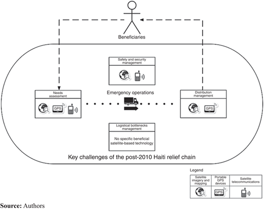
Analyzing the responses to Question 1 provides a contextual understanding of key logistics challenges among the 14 main operations carried out by humanitarian workers in the aftermath of the 2010 Haiti earthquake. This question assesses the difficulty level in managing logistics, using both a five-point Likert scale and a ranking table. The results are presented in Table VI. First, the Likert scales were used to calculate the median and standard deviation (SD) for each operation, revealing two key logistics challenges: “logistical bottlenecks management” and “distribution management.” Second, the results obtained from the ranking table were used to determine a ranking score for each operation by calculating a weighted sum, where the number of participants who ranked it first had a weight of 3, the number of participants who ranked it second had a weight of 2, and the number of participants who ranked it third had a weight of 1. Thus, the ranking scores highlighted four key logistics challenges: the two that have been previously identified with the Likert scales were confirmed and two new challenges, “needs assessment” and “safety and security management,” were revealed.
The foremost difficulty concerns logistical bottlenecks management, which is related to major urban traffic congestion and delays in transporting and delivering aid to beneficiaries in Haiti due to large-scale destruction. The results indicate that this operation has a small SD (0.9), which shows that this operation was a main concern for the majority of participants. In particular, the WPF global fleet manager commented that both damaged port facilities and customs procedures created important bottlenecks. The second most important difficulty revealed by this study concerns distribution management and refers to issues faced by the participants in providing aid in a timely and safe manner to the affected populations. Government agencies as well as NGOs faced several problems in providing aid supplies to the affected populations, resulting in severe desperation, frustration, and violence among those populations. According to the MSF initial assessment officer, aid distribution was very difficult inside Port-au-Prince due to potential riots. The third most important difficulty encountered was needs assessment; that is, difficulties when evaluating aid requirements for people killed, injured, or displaced in terms of food, water, equipment, medical supplies, and staff. The WFP liaison officer explained that assessing local needs was not easy for many organizations due to numerous and dispersed victims as well as access and communication issues (differences between spoken language). The fourth key challenge faced by the participants was safety and security management. This activity refers to the management of thefts, losses, accidents, injuries, or attacks, including protection of both the disaster-affected population as well as the relief staff and materials (Roy et al., 2012). According to the MSF initial assessment officer, many relief organizations were blocked due to security issues.
5.2 Benefits of the four satellite technologies for disaster relief logistics
In Question 2, the participants assessed the level of benefit of the four satellite technologies in managing each of the 14 logistics operations through the Likert scales. The results, including the median scores and the SDs, are detailed in Table VII. Technologies that achieved a median score greater than 3 are considered beneficial (4=medium high level of benefit; 5=high level of benefit). The results demonstrate important benefits related to the use of satellite technologies for disaster relief logistics. In particular, these technologies were useful for managing nine out of the 14 logistics operations and three out of the four most critical logistics operations. Throughout a simplified relief process, Figure 2 depicts the key results obtained from Questions 1 and 2, including both the key logistics challenges and the corresponding most beneficial satellite technologies.
Satellite mapping is the most beneficial among the four satellite technology categories since it helped manage nine out of the 14 operations. In particular, it supported three out of the four most critical operations, as suggested by the literature. First, it facilitated needs assessment, one of the very first required operations in the aftermath of a disaster. Accordingly, the head of international programs for FRC commented that satellite mapping was very useful during the initial days for quickly assessing and locating affected areas and deploying relief supply chains. Second, it facilitated distribution management. Finally, satellite mapping supported safety and security management by giving an overall picture of the situation on the ground. Portable GPS devices represent the second most beneficial satellite technology, supporting six operations. In particular, the results confirm that this technology can improve needs assessment by providing precise in situ spatial information of refugee camps, damaged buildings, and other points of interest (i.e. their exact location and dimensions) and aid distribution management by effectively determining the coordinates of actual and potential distribution centers. In the initial days, the MSF logistics coordinator explained that portable GPS devices were mostly used by field workers to check their position and travel through the disaster area. The literature describes the role of GPS vehicle tracking technology in facilitating fleet management, including vehicle routing, as well as safety and security management, by enabling near real-time adaptation to the ground situation evolution. However, the results indicate that GPS vehicle tracking was only beneficial for routing. The head of international programs for the FRC suggested that this technology can be more useful in the medium and long term (i.e. after the emergency response stage) for managing security of vehicles and staff traveling in high-risk areas. Results obtained from the case study reveal that satellite telecommunications can be very useful for assessing needs and for improving safety and security. The head of radio communications for MSF explained that satellite telecommunications were very convenient in that it enabled international communications between field workers, international headquarters, and the families of relief staff. Furthermore, the IOM program manager argued that this technology was very useful in some remote areas of Haiti without any cellular or radio network.
5.3 Barriers to the use of satellite technologies
In responding to Question 3, the participants had the opportunity to describe any difficulties they encountered in using each of the four satellite technologies. Both the words they used and their meanings were captured and segmented to maximize the information collection process and identify similar concepts and ideas (Gioia et al., 2012; L’Écuyer, 1990; Rourke et al., 1999). These qualitative data were filtered and categorized according to common difficulties (Dey, 1993) experienced by the participants when using satellite technologies.
The results confirm two important common organizational problems within the humanitarian community when using satellite technologies: the lack of skilled staff in GIS and high cost of satellite telecommunications. First, the lack of skilled humanitarian field workers in GIS seemed to be the main concern of participants when using satellite mapping, portable GPS devices, and GPS vehicle tracking. They indicated that both the lack of training in GIS and the high level of low-skilled volunteers and staff turnover within NGOs increased difficulties in using satellite technologies and delays in relief efforts as procedures had to be continuously explained. The negative impact of volunteers and staff turnover on capacity building and skills was highlighted in previous research on disaster management (Buddas, 2014; Kruke and Olsen, 2012; Van Wassenhove and Pedraza Martinez, 2012; Varvas and McKenna, 2013). Kovács et al. (2012) also noticed that relief organizations had very few resources and time for training people to use technology in the field in the aftermath of the Haiti earthquake. Furthermore, the Care International coordinator commented that major difficulties were linked to both insufficient skills and organizational culture toward satellite technology within NGOs. Cutter (2003) confirmed that the professional culture of this category of relief organizations can impede the adoption of satellite technologies. Second, the participants pointed out the high cost of satellite telecommunications as a major adoption barrier. However, this was not the case for satellite mapping, portable GPS devices, and GPS vehicle tracking. It is likely that limited financial resources within NGOs induce important difficulties in recruiting permanent skilled workers, developing training programs and acquiring sophisticated technologies.
The results also indicate difficulties that are specific to each satellite technology. Regarding satellite mapping, the results confirm the two main technical difficulties identified in the literature: low resolution and insufficient updates. According to the Care International coordinator, additional field surveys were required to evaluate accessibility to distribution points due to low quality of satellite images. The participants revealed two main technical difficulties related to the use of portable GPS devices: some receivers were too slow in providing the required data or did not provide accurate coordinates, especially when smartphones were used as GPS positioning receivers. This delayed needs assessment and impeded effective aid distribution to beneficiaries. The responses to Question 3 also highlight three main difficulties when using satellite telecommunications. First, the participants confirmed that the cost of utilization is a main concern. Satellite telecommunication providers, such as well-known Inmarsat, have developed integrated solutions (devices and services) for the humanitarian community. The results reveal that the cost of satellite phone terminals (US$1,500-3,000) and prepaid SIM cards (US$1-2 per minute and US$5-7 per megabyte) was too high for many NGOs. Second, they criticized the limited bandwidth of such a technology, which led to very slow information and data exchange. Third, some participants also declared that the use of high-value satellite telecommunications equipments could lead to negative externalities in terms of security by increasing the risk of theft and hacks. To address these problems, Varvas and McKenna (2013) suggested prioritizing the use of more traditional terrestrial communication systems such as VHF radios, which are easier to use, cheaper, and broadly deployed even in poor and remote villages. Some participants also explained that for local communications in Port-au-Prince satellite telecommunication was not as useful because VHF radio remained functional. The results from Question 2 revealed that GPS vehicle tracking technology was only useful for vehicle routing. The participants did not agree on its benefits for reducing bottlenecks and managing security in the case of the Haiti crisis. In Question 3, many of them declared that GPS vehicle tracking was not appropriate in the Haitian context because of the limited geographical extent of relief operations within the urban area of Port-au-Prince (Van Wassenhove and Pedraza Martinez, 2012). In particular, they argued that this technology would be more beneficial for managing transportation operations on long distances and to remote areas. The WFP logistics officer commented that the use of communication technologies, such as VHF radio systems, provided a simpler, faster, and more flexible solution for tracking vehicle location and managing security within Port-au-Prince.
5.4 Research findings
The role of satellite technologies in humanitarian emergencies is not well-documented. This paper adds to current academic and practical knowledge on the topic by providing empirical results based on a questionnaire survey and supported by the numerous comments given by the participants. Table VIII synthesizes the main contributions of the research, including the findings obtained from the literature review and the case study. From a global perspective, this paper gives the reader a first overview of the role of the relevant satellite technologies deployed in a post-disaster response relief chain. Although some studies have been published on the applications of satellite imagery and mapping in pre- and post-disaster actions, little is known about the use of GPS technologies (portable devices and vehicle tracking). Moreover, to the best of our knowledge, no research has been conducted on the specific role of satellite telecommunications in emergency operations. This paper partly fills this gap by means of an in-depth case study. The empirical findings also corroborate some information identified in previous research such as the main benefits of satellite mapping and portable GPS devices and the lack of skilled staff in GIS within NGOs. Regarding the role of GPS vehicle tracking, the results differ from the existing literature by highlighting little interest in this technology for relief organizations operating over short geographical distances.
6. Conclusions
Satellite technologies have fundamentally changed the manner in which humanitarian organizations respond to catastrophic disasters by facilitating their activities in uncertain, complex, and highly dynamic environments. However, few studies analyzing their practical role in post-disaster relief logistics have been published. This paper bridges this gap by providing insights on the benefits and limitations of the most commonly used satellite technologies in emergency operations: satellite imagery and mapping, portable GPS devices, satellite telecommunications, and GPS vehicle tracking. The research was developed through a preliminary literature review and a complementary questionnaire survey on the 2010 Haiti earthquake, a catastrophic disaster that created an immediate demand for accurate information, making it a turning point in technology-supported relief operations.
The findings indicate that satellite technologies can help tackle most of the main logistical challenges encountered by relief actors. Satellite mapping can principally support the needs assessment, distribution of relief supplies and security management by providing an overall picture of the situation on the ground. Portable GPS devices can improve needs assessment and distribution activities through precise geo-referenced data collected in the field. Satellite telecommunications can play a crucial role in the first few days following a disaster in establishing flexible emergency communication links and providing rapid needs assessment and security management capabilities. GPS vehicle tracking can support transportation and security management for vehicles traveling on long distances and to remote areas. In sum, satellite technologies can be crucial for managing relief operations following large-scale disasters by providing spatial information inputs for mapping the disaster impact and locating staff and vehicles across a wide area and enabling resilient communication links via satellite. Nevertheless, the research revealed that the use of satellite technologies can be limited by several difficulties, which are mostly related to organizational barriers within NGOs, such as the lack of skilled workers in GIS and high costs.
The results suggest two main recommendations to facilitate the use of satellite technologies within the humanitarian community. First, relief organizations should develop regular training programs and dedicate budgets to these technologies during the preparedness phase. Second, this paper recommends to develop cooperation mechanisms between satellite technology providers and the humanitarian community through international initiatives, such as the International Charter on Space and major disasters, the European program Copernicus and the Tampere Convention on Emergency Telecommunications. Strengthening interorganizational links would enable the space industry to provide access to satellite technologies at no cost in the case of a disaster and to better take into account end-users’ needs while designing satellite-based tools in order to offer easy-to-use solutions that allow for quick adoption. Finally, organization-level commitment and cultural change are necessary to ensure that both humanitarian field workers and managers trust and take advantage of satellite technologies in relief supply chains.
Despite useful insights, the results of this study cannot be generalized to other types of disasters (e.g. slow-onset disasters), which often require different modes of organization and for which different technologies are suitable. We assume, however, that the technological benefits, limitations, and recommendations that are highlighted in this case study are relevant to most urban catastrophic disasters. Further research will help us to understand the many applications of satellite technologies in relief efforts. In particular, we encourage the academic community to replicate this study in new disaster fields and to analyze the importance of satellite technologies within different types of relief organizations.
The humanitarian field is being affected by technological evolutions that transform emergency operations. Emerging technologies, such as social media and satellite-based tools, are becoming central to support humanitarian action in catastrophic settings, changing isolated relief supply chains into coordinated and resilient delivery channels.
The authors first thank the participant organizations for their time and contribution to this study. The authors also express deep gratitude to Antoine Petibon from the French Red Cross for the fruitful discussions that helped enhance the quality of this paper. This research was partly funded by the Direction Générale de l'Armement (DGA), the Centre National d'Études Spatiales (CNES), and the Canadian Natural Sciences and Engineering Research Council (NSERC) under the Grant 370597-14. This support is gratefully acknowledged. The authors finally thank the Humanitarian Response Lab of the MIT Center for Transportation and Logistics for its support.