

Refugee camps are not easily welcomed by local communities. The purpose of this paper is to outline a structured approach to support the decision-making process for siting refugee camps in mainland Greece using multiple criteria, including local opposition. A suitability analysis generates a list of potential sites and a multiple criteria evaluation is applied. The motivation is the development of a methodology that can support choices and policies regarding the refugee camps siting problem, incorporating the need to address local opposition.
The proposed methodology combines geographic information systems (GIS) with multiple criteria decision-making (MCDM) techniques. These are used to develop a location classification and ranking model based on related criteria and subcriteria, attributes and weights. The region of Peloponnese in Greece is selected as a case study to validate the approach.
The lack of predefined candidate sites for refugee camps necessitates, initially, tackling a site search problem to generate a pool of potential sites through a suitability analysis. Subsequently, using the GIS the pool yields a subset of potential sites, satisfying all the criteria to setup a refugee camp. Through the current analysis the suitability of the single existing refugee camp site in Peloponnese can be evaluated. Finally, a “with and without” analysis, excluding the social criterion, depicts the changes in the candidate sites pool and their scores.
There is a lack of relevant literature taking into account the local opposition or sociopolitical implications as decision criteria. The selection of the appropriate criteria is a complex process that involves the cooperation of many experts. The main criteria, subcriteria and their attributes were determined according to existing literature and authors' informed judgment.
The proposed methodology can help decision-makers to setup a decision-making system and process for identifying refugee camps' sites using multiple criteria, including local opposition.
1. Introduction
From 2015 onwards, Europe is facing massive refugee and migrant flows from its southeastern borders, mainly due to the Syrian crisis. They go in primarily through Greece, and eventually pass through the western Balkans (Tyyskä et al., 2017). Refugees, including asylum seekers and beneficiaries of international protection, are persons mainly fleeing armed conflict or persecution. Migrants choose to move out not because of a direct threat of persecution or death but mainly to improve their living conditions; that is, to find better working conditions, acquire education, reunite with their family and so on. Despite the fundamentally different motivation for relocation, these two groups are often treated in unison when provided with settlements (often a subject of debate and often referred to as “refugee camps”), until the completion of a screening process that results in either granting asylum and relocation or deportation (UNHCR, 2016).
Focusing on Greece, the eastern Aegean Sea islands are excessively burdened with the task of receiving refugees and migrant flows, as they are the main entry points for Europe due to their proximity to the Turkish coasts. In addition to being the first if not the main strongholds to receive and treat refugees and migrants, they are unprepared to react and manage their sheer numbers. From January 1st 2016 and until June 4th 2020, the total number of refugees and migrants’ arrivals to these islands was 305,887 (IOM, 2020). The first facilities for the reception and screening of incoming flows are established there. Since their capacity is limited and there is a continuous stream of arrivals, re-distributing them in mainland Greece is inevitable.
Given the incessant stream of people arriving, deploying an extended range of sustainable refugees and migrants hosting facilities is a major challenge for Greece. According to Terouhid et al. (2012), a facility can be characterized as sustainable when its economic, social and environmental objectives have been taken into account in the decision-making process, resulting in the proper social, economic and environmental decision criteria. In addition to multiple infrastructural factors affecting the establishment of such facilities, the problem is aggravated as decision-makers must also take into account the existence of local opposition, the so-called “Not-In-My-Back-Yard” (N.I.M.B.Y) phenomenon, Plastria et al. (2013) and Ferwerda et al. (2017), at both the entry point islands and the mainland areas.
In general, the solutions to the problem of hospitality generated by massive refugee and migrants flows vary from country to country and depend on the policy implemented, the magnitude of the flows to be accommodated and the existing hosting infrastructure. Greek authorities have considered until now these refugee camps as temporary, lacking pre-defined specifications and a structured methodology about where to site them. Therefore, in order to address the urging and also excessive needs, they very often resort to using any available infrastructure, which may not always be suitable for the task: abandoned military premises, hotels, apartments and even old monasteries. The major problem with this approach is that because the screening process can be quite lengthy; thereby the camps are actually long termed (IOM, 2020) and it is imperative for them to satisfy more generic sustainability criteria to the existence of a plain electricity and sewage network.
In this paper, a structured approach to support the decision-making process for siting long term refugee camps is presented. A suitability analysis generates a list of potential sites and a multiple criteria evaluation is applied. The region of Peloponnese in Greece is used as a case study. The motivation is the development of a methodology that can support choices and policies regarding the refugee camps siting problem, including the need to address the N.I.M.B.Y. phenomenon for the first time in the decision making criteria, according to the best of the authors' knowledge.
The remainder of the paper consists of four sections. In the literature review, in Section 2, multi-criteria decision-making (MCDM) methods resolving the refugee camps' siting problem with the assistance of geographic information systems (GIS) are presented. Then, the impact of the refugee camps and the “Not-In-My-Back-Yard” phenomenon is analyzed. Section 3 defines the four-step developed methodology that aims to identify the suitable sites for refugee camps and in Section 4 this methodology is applied in a case study of the Region of Peloponnese in Greece. Finally, in Section 5, a summary of the research and the limitations and implications of the proposed methodology are presented.
2. Literature review
2.1 Facility siting using MCDM and GIS
In order to identify the most suitable areas for siting a facility, researchers use operations management including MCDM methods. MCDM is defined as “The study of methods and procedures by which multiple and conflicting criteria can be incorporated into the decision process” (Zardari et al., 2015). MCDM provides the structure to fill the gap in the decision-making process as well as the tools to evaluate and prioritize a large number of conflicting decision criteria and, moreover, to evaluate and classify the alternatives (Curran et al., 2014).
For siting facilities, the decision-making process is divided into two stages in order to better understand the complexity of the problem. In particular, the first stage of the problem is classified as a site search or site generation problem or suitability analysis (Erkut and Neuman, 1989). This is followed by site selection, that is, the second stage of the final decision to site a facility. Therefore, if there are no a priori candidate sites, the facility siting problem is split into two individual problems that are tackled separately and by different methods (Malczewski and Rinner, 2015).
Suitability analysis determines both the suitability of the sites for a given purpose and their characteristics (Cova and Church, 2000). It systematically identifies and ranks possible sites for a particular use and is divided into two types: “Absolute Suitability”, according to which a site is suitable or not and “Relative Suitability”, according to which the site suitability varies, with some areas being more desirable or suitable for a particular use than others (Church και Murray, 2009). Identifying a set of feasible alternatives allows the decision-making process to progress, which is often preferable than stalling it until an “excellent” site is identified.
Moreover, suitability analysis can be divided into two categories, depending on the goal set: the “explicit site” goal targets analytical and detailed determination of the suitable areas boundaries for siting and mathematical programming models are used and the “good area for site” goal targets suitable areas where candidate sites are likely to be found, using MCDM techniques.
In MCDM, the basic principle for the evaluation is the construction of an evaluation matrix (Carver, 1991; Voogd, 1982), whereas different techniques can be used to prioritize criteria according to the decision makers' preferences, such as applying a weight to each criterion.
In suitability analysis, criteria are usually weighted using the analytical hierarchy process (AHP) (Eastman et al., 1995; Eldrandaly, 2013; Ferretti, 2011; Malczewski, 1999; Saaty, 1987, 2008). The main reason is that its classification scheme makes it easier to compare criteria pairwise in cases where weighting is not performed by experts and derive accurate ratio scale priorities, as opposed to using traditional approaches of “assigning weights,” which can also be difficult to justify.
At this point, all criteria are aggregated to obtain a score value for each area (Xiao et al., 2002). The process of aggregating the criteria is known as a “decision rule” and assessment is the process of implementing a decision rule. The most commonly used multi-criteria aggregation process is the weighted linear combination (WLC) or simple additive weighting method (SAW). Alternatives are scored per criterion, then multiplied by a weight coefficient and finally summed to produce an overall and uniform score for each alternative (Drobne and Lisec, 2009; Kasim et al., 2011; Shenavr and Hosseini, 2014).
Suitability analysis is often implemented using GIS combined with the above mentioned MCDM techniques. In a GIS environment, the suitability analysis problem is translated to spotting areas on a map, such as cells or polygons and suitability results analyzing each of these areas. Therefore, each area represents an alternative and according to WLC method the value of the area is multiplied with the weight coefficient of the criterion. This is repeated for all the areas, for each criterion. Then the weighted values for all criteria are added to each corresponding cell and the sum for all criteria is presented. That is:
where S is the suitability, is the weight coefficient for criterion i and is the score that the base unit (cell) has for criterion i.
The combination of GIS with MCDM methods is increasingly used for resolving a wide range of decision and management problems. They prove exceptionally useful tools for decision makers. This combination has been used in multiple domains, including environmental, transportation, urban planning, waste management, agriculture, forestry and natural hazard studies to tackle decision/evaluation problems such as land suitability, site search, scenario evaluation and resource allocation among others (Malczewski, 2004, 2006; Zhang et al., 2013).
2.2 Refugee camps' siting problem with MCDM methods combined with GIS–the N.I.M.B.Y. phenomenon
Most papers dealing with siting refugee camps are in the field of disaster management and mostly for the selection of temporary sites rather than permanent settlements (Seifert et al., 2018). The majority in this area of spatial research focuses on the location of facilities such as distribution centers and humanitarian aid warehouses. Research for siting refugee camps intended for housing war refugees is scarce and there is a literature gap on their site selection (Çetinkaya et al., 2016).
Contrary to the aforementioned, there are a few studies that focus on changing the view of war refugee camps from temporary hosting facilities to long-term settlements, combining benefits for both local communities and refugees. Turner (2016) mentions that while large numbers of refugees reside in camps, none of the three durable solutions favored by the United Nations High Commissioner for Refugees (UNHCR)–repatriation, resettlement and local integration–mentions camps. Refugee camps are temporary measures until another solution is found. Meanwhile, the length of this temporary stay is unknown (“indeterminate temporariness”). Moreover, Jahre et al. (2018) argue that the “traditional” approach for siting refugee camps has often been to isolate them from the local community, but a proposed new approach based on longer-term refugee camps is gaining increased attention among governments and humanitarian organizations (Çetinkaya et al., 2016).
This new approach is achieved through the inclusion of social criteria in the site selection process, like the interaction/integration with local communities and the avoidance of touristic areas as candidates for siting camps. In Yassen (2019) it is stated that Article 34 of the Refugee Convention provides that refugees' hosting countries should as far as possible facilitate the assimilation and naturalization of refugees, where “assimilation” has been replaced with integration in the hosting country. It is argued that social criteria, expressed mainly via the proximity to the local population (Çetinkaya et al., 2016), might be an idea in this new approach to break the isolation that refugees living in camps often experience. Segregating refugees from the host community in terms of employment, education, and social and cultural networks has negative consequences (Jahre et al., 2018) and this is something that the decision makers must certainly take under consideration.
On the other hand, focusing on Europe and USA, several countries' authorities face negative reactions to the existence of migrants and refugees' hosting facilities by local societies, even before the dramatic increase in their flows in 2015 (Ferwerda et al., 2017). For example, there are two related surveys for the cities of Ioannina and Athens in Greece regarding immigrant reception camps and residents' perceptions on immigrants (Karamani, 2012; Petridis, 2009). Summarizing these surveys, it seems that a local society hosting migrants and refugees, understands the unfairness of their difficult living conditions. Nevertheless, although it most often voices the view that most often migrants and refugees may positively affect economic development, it remains negative in their staying in areas where the native population lives.
Ziller and Heizmann (2020), using data from the European Social Survey in 2012 and 2016, merged with regional economic conditions, show that in regions where the state of the economy is predominantly evaluated as being prosperous, immigrants report higher levels of discrimination. This enhances the consideration that favorable economic conditions may, paradoxically, increase native-immigrant trust asymmetries. This is observed in Greece in the case of siting refugees, where in areas with higher income level like Athens and its surroundings, the resistance of the local residents was much stronger.
According to Plastria et al. (2013), the social response for a facility to be built near an urban area depends on the type of the facility. The phenomenon of the local community opposing facilities is called N.I.M.B.Y. and such facilities are characterized as semi-obnoxious (Carrizosa and Plastria, 1999), semi-desirable or pull-push. A classification of the studied relevant literature with regards to the causes behind the refugees' flows, the camps' perceived lifetime, the utilized methodology and a special focus on the social criteria taken under consideration is illustrated in Table 1.
Literature classification
| References | Refugees flow cause | Time horizon | Methodology | Social criteria |
|---|---|---|---|---|
| Şentürk and Erener (2017) | Earthquake | Temporary | MCDM (AHP)/GIS | Νo |
| Omidvar et al. (2013) | Natural disasters | Temporary | MCDM (TOPSIS-ELECTRE-SAW-AHP)/GIS | No |
| Pérez-Galarce et al. (2017) | Earthquake | Temporary | Mixed Integer Linear Programming/GIS | No |
| Timperio et al. (2017) | Natural disasters | Temporary | MCDM (Fuzzy AHP)/GIS | No |
| Alexaki (2018) | War | Temporary | MCDM (AHP)/GIS | No |
| Mong et al. (2014) | War | Long term | MCDM (AHP)/GIS | Population Density – Interaction with local communities – Area's Welfare |
| Çetinkaya et al. (2016) | War | Long term | MCDM (Fuzzy AHP – TOPSIS)/GIS | Tourism-Population Proximity-Area's Welfare |
| Jahre et al. (2018) | Natural disasters – man-made disasters | Long term | Multiple case studies | Interaction with local communities |
Taking the above into consideration, this paper approaches the long-term refugees' camps siting problem for the first time in Greece by using a GIS-based MCDM methodology to create a relative suitability map with a “good area for site” goal. The criteria, their classification/constraints and the scoring method are based on the relevant literature and authors' informed judgement, taking into account the N.I.M.B.Y. phenomenon by considering the local opposition. The refugee camps are identified as semi-desirable for two reasons: First, due to the existence of local opposition to siting the facility near population centers. Second, in decision-making, a realistic approach to problems is considered to be critical in order for the decision-maker to take into account the impact it may have on the local community (Erkut and Neuman, 1989). That is, the decision-maker should be aware of the essence of the problem, since he/she has the obligation to take into account the satisfaction of the needs of both the refugees and the local communities, in order to make a rational decision, not for the optimal but for a suitable and sustainable siting (UNHCR, 2015).
3. Methodology
The suitability analysis is conducted in four main steps: the selection of the criteria, the determination of their relative importance, the combination of the weighted criteria for the calculation of the final score of each alternative area and the step of acquiring results by applying a decision rule.
3.1 Step 1 – Standardization and criteria scoring
The objective to be achieved is identified as finding the most suitable candidate areas for siting refugee camps. Then, decision rules, criteria, subcriteria and restricted areas are identified. Decision rules are divided to classification and selection rules (Eastman et al., 1995). Classification decision rules are defined first in order to determine which areas are appropriate and which are not for further analysis. Selection decision rules will be determined later, when the suitability analysis is complete, in order to select the most suitable areas.
Applying the classification decision rules leads to the criteria attributes, which are grouped into five classes (Table 2). The boundaries of each class depend on the preferences of the decision-maker. This step is followed by the collection, processing and creation of spatial data using GIS. For these processes, the Arcgis 10.1 software was used for creating the thematic layers for each of the classes.
Scoring description
| Score | Suitability description |
|---|---|
| 1 | Minimum suitability |
| 2 | Low suitability |
| 3 | Moderate suitability |
| 4 | High suitability |
| 5 | Excellent suitability |
Then, the five attribute classes of each criterion are standardized to facilitate a common scale for comparing all the criteria. Each class receives an appropriate score (Table 2). The score indicates the decision-makers preference for how suitable is each class.
Criteria standardization can be accomplished in two ways, either linearly or non-linearly (Eldrandaly, 2013). In the first case, techniques that alter the initial values are used, resulting in linearly correlated initial values of the attributes and final values. However, there are cases (Mahmoud et al., 2014) where the standardization of criteria values is performed by subjective criteria according to the preference of the decision-maker or team of experts (Longley, 1999). They assign scores to the criteria not using linear correlation, as previously mentioned, but approximating asymptomatically the maximum or minimum level of suitability. This choice, therefore, depends solely on the policy or preference of the decision-maker and is used in cases where there are push-pull factors, such as in the case of undesirable installations (for example Al-Hanbali et al., 2011), where the most unsuitable sites are at the edges of the acceptable solutions that are the nearest and the furthest ones, since the nearest ones affect the local population, while at the furthest ones the transportation costs are higher. Finally, non-linear standardization is found in the literature as a non-linear transformation (Aiello and Attanasio, 2004). Methods of non-linear transformation are rank transformation and ranking scoring transformation.
In the framework proposed in this paper both linear and non-linear methods are used, depending on the nature of each criterion.
3.2 Step 2 – Criteria weighting
In the absence of specific and generally accepted data to determine the significance of each criterion for refugee camps worldwide, weighting (i.e. deriving relative priorities) is based on existing literature and identifying hosting structures as semi-desirable facilities using AHP with the application of Super Decisions tool (Super Decisions, 2017). Super Decision was selected for two reasons: First, due to its ease of use and second due to the fact that it has already been used for the problem studied (e.g. in Çetinkaya et al., 2016). The weight of each criterion is different and thus it is first required to derive from pairwise comparisons its relative priority using the numerical scale for comparison developed by Saaty (1987) (“Extremely important” = 9 or 8, “Very Strongly more important” = 7 or 6, “Strongly more important” = 5 or 4, “Moderately more important” = 3 or 2 and “Equally important” = 1).
In order to perform the pairwise comparison, it is needed to create a comparison matrix of the criteria involved. This is performed using the Super Decision software. The same process is implemented for subcriteria and the outcome are the normalized weights for each main criterion and subcriterion.
3.3 Step 3 – Aggregation of weighted criteria
All criteria for each area/cell based on their weight coefficient are aggregated using the WLC method via the corresponding GIS tool (raster calculator). This renders a new thematic layer showing the suitable areas based on the overall score for each cell ranging from 1 to 5.
3.4 Step 4 – Results
Using the relevant GIS tool, it is now possible to identify the cells with meeting a threshold score. At this point, it is possible to process the map and further remove any restricted areas. The areas left after this step are the candidates suitable for siting refugee camps. The process of removing restricted areas is often performed earlier on in order to carry out the analysis only for the most suitable areas. In this instance, however, it was preferable at this stage because it gives more flexibility to the analyst or the decision-maker to make further adjustments during the analysis (Caradima, 2015). If these areas were removed from the beginning of the analysis and the need arose to modify some of the assumptions that may include these areas, the suitability analysis would have to be repeated, making it more laborious than necessary.
4. Case study–Region of Peloponnese
4.1 Determination of the study area
In this case study, mainland administrative regions of Greece are considered. The islands of eastern Aegean (Samos, Lesbos, Chios, Leros, Kos) were excluded, as they have been facing face an aggravated situation of large refugee and migrant flows from the Turkish coasts for a number of years and, especially considering their limited area sizes, they already have over-populated refugee camps.
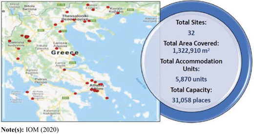
Greek authorities are already using mainland Greece facilities as refugee camps, such as inactive military camps or hotels/apartments in urban areas. In April's 2020 International Organization for Migration (IOM) Office in Greece Site Management System (SMS) factsheet, it is reported that there are 32 refugee camps located in mainland Greece (IOM, 2020) (Figure 1). Of the total, 30 of them are long-term accommodation sites (LTAS), 1 is a site of 9 hotels and there is a single transit site located in Korinthos. The latter is the only one located in the administrative region of Peloponnese (Ministry for Migration Policy and Ministry of Digital Policy, Telecommunications and Media, 2018), operating exclusively as a hosting point for migrants that are decided to be deported. From this angle it is fundamentally different from the refugee camps that this study aims. Therefore, since Greek authorities have decided that the relocated refugees should be distributed to the entire mainland Greek territory and the Region of Peloponnese is the only one in Greece without an official LTAS, it was selected as the most suitable in Greece to validate the proposed methodology.
4.2 Step 1: Standardization and criteria scoring
Once the thematic layers are created, the cells' criteria values for each one of the thematic layers are combined into a single layer. Standardization on a common basis is necessary in order to be comparable and yield a single score for the final thematic layer. For this reason, a common regular grading scale is used based on the degree of class suitability, where classes are structured through GIS software, taking values from 1 to 5 according to Table 2.
There are no explicit site specifications for refugee camps. Thus, in their absence, the criteria selected are based on the UNHCR's rather limited findings and suggestions (UNHCR, 2015) and related surveys. In particular, four main criteria with eight subcriteria were selected, as presented in the following.
4.3 Topographic criterion
A topographic criterion reflects the suitability of the soil surface. Primarily, this refers to land characteristics that would affect for instance the cost of building or factors that can have a negative impact on the operation of the facility or the welfare of the refugees, such as water accumulation or extreme weather conditions. The subcriteria utilized in this paper are slope and elevation.
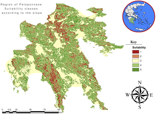
4.3.1 Slope
Slope is an important factor affecting on one hand the cost of constructing the refugee camps and on the other hand contributing significantly to limiting the effects of stagnant waters that deteriorate the living conditions of the hosted population. According to UNHCR (2015), the appropriate slope in the areas that refugee camps are sited is between 2 and 4%, since a slope of less than 2% can lead to stagnant water accumulation, while in areas with a slope of above 10% there is a risk of soil erosion and the construction cost of the facility increases significantly. Still, slope is not sufficient enough to identify candidate regions and further assessment is necessary. In the context of this paper analysis, there is no corresponding limit on the suitability of the sites and the slope subcriterion is grouped into five classes based on UNHCR (2015) and Mong et al. (2014) analysis.
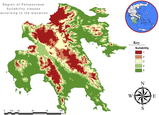
4.3.2 Elevation
Elevation has a direct influence on the smooth living of refugees within the facility. Further, both the weather conditions of the host country and the climate of the countries from which the refugees originate should be taken into account. Areas with an altitude up to 1,000 m include the lowland and semimountainous areas, which are more suitable than the mountainous areas above the altitude of 1,000 m. Standardization with regard to the suitability of the classes is performed with a linear correlation based on the altitude. The class containing the smallest value receives a higher score (negative correlation).
4.4 Operational criterion
The operational criterion concerns factors that affect the operation of refugee camps and are directly related to meeting the refugees' needs. In this case it includes the subcriteria of distance from the nearest airport, distance from the nearest police station, distance from the nearest hospital or health center and distance from the major road network.
4.4.1 Distance from the nearest airport
In 2015, due to the refugee crisis in Europe, the European Commission proposed to use an emergency response mechanism for the first time in order to set up a temporary relocation scheme. According to UNHCR, from September 2015 to August 2017 when the resettlement agreement applies, about 20,323 persons have moved from Greece to other European Union (EU) countries (UNHCR, 2017). In addition, according to Çetinkaya et al. (2016), refugee camps should be close to an airport to take advantage of international humanitarian aid. Consequently, the distance of refugee camps from the nearest airport is a factor that has direct impact on total transportation costs. For this reason, areas with a distance of up to 110 km from the nearest airports are selected. Athens International Airport located in the region of Attica was included in the analysis because of the proximity to the northeastern cities of Peloponnese. The limit of 110 km was set in order to minimize the exclusion areas.
For this subcriterion, the relevant legislation for airport security and the fact that the airport is a critical facility were also considered. UNHCR proposes to site refugee camps within a reasonable distance from critical facilities such as military facilities, including airports, to ensure the safety and protection of refugees (UNHCR, 2015). For this reason, the first distance class up to 13 kilometers is scored as the less suitable.
4.4.2 Distance from the nearest police station
All countries should provide security to the refugees. In addition, the protection of women and minors is an important concern of the host state, as they are vulnerable groups, which can easily be victims of criminal activities both inside and outside refugee camps. Women as victims of rape and exploitation are frequent phenomena in hosting facilities at an international level (Edwards and Ferstman, 2010, p. 186). In the case examined, according to Greek legislation, either the Greek Police or private security companies may guard the facilities. Due to the lack of relevant data, and in order to reduce any overheads for the transportation of security personnel to the facility or to deal with incidents within a short period of time, sites that are up to 10 kilometers away from a police station are deemed as more favorable. Standardization with regard to the suitability of the classes is performed with a linear correlation based on the distance. The class containing the smallest (distance) value receives a higher score (negative correlation).
4.4.3 Distance from the nearest hospitals or health centers
Refugee medical treatment is an important factor that should be taken into account when selecting the site of refugee camps. UNHCR highlights the importance of this provision by the host country to the refugees within the facilities, specifying that the distance between the refugee camps and the hospitals or health centers cannot be more than 5 kilometers (UNHCR, 2015). Because of the significance of this factor, this limit was adopted in the study. Standardization with regard to the suitability of the classes is performed with a linear correlation based on the distance. The class containing the smallest value receives a higher score (negative correlation).
4.4.4 Distance from the major road network
When constructing refugee camps, the need to extend the road network yields an extra cost that is not included to the facility construction. It is considered necessary that the refugee camps are sited near the road network in order to reduce construction and transportation costs but also to make public transport and service centers more accessible to the refugees (UNHCR, 2015).
Further, based on research for searching sites for the disposal of solid waste, the distance between 200 and 1,000 m has been rated as the most suitable distance from the road, with the aim of reducing costs (Al-Hanbali et al., 2011). In the absence of precise locations, a maximum distance of 1,000 m from the major road network was considered as equivalent. Standardization with regard to the suitability of the classes is linearly correlated based on the distance. The class containing the smallest value receives a higher score (negative correlation).
4.5 Social criterion
Given the significance of the N.I.M.B.Y. phenomenon, the social criterion is probably the most important in this analysis as already noted. The decision-maker should take into account all factors that contribute to the construction of a sustainable facility, including social ones. Social criteria with respect to refugee camps are important as they relate to two groups of people: local communities seeking to push facilities away from urban centers and refugees seeking to pull facilities as near as possible to the urban centers to meet their needs. For this reason, the subcriterion of the distance from the center of a city with population over 2,000 inhabitants was taken into account. This population limit was considered due to the fact that above this size in Greece an urban settlement is considered a town and not a village, thus offering more employment and education opportunities to refugees.
It has to be mentioned here that candidate areas' welfare (in terms for example of household income or number of people under the poverty limit) was not considered, due to the contradicting evidences mentioned in Section 2.
4.5.1 Distance from the center of the city with population over 2,000 inhabitants
Any social planner should think one universal factor in all NIMBY conflicts: geographical proximity (Dear, 1992). Moreover, according to UNHCR, planning and management of refugee camps should be performed in such a way as to avoid confrontations with the local population (UNHCR, 2015). Taking into account the local opposition to refugee camps, areas as far as possible from urban centers should be selected. However, bearing in mind that refugees want to meet the same needs as local people in order to live with dignity, areas as near as possible to urban centers should be selected. In this case, refugee camps are treated as semi-desirable facilities and the siting problem solution should be a compromise between the two opposing goals. Due to the lack of previous case data, a maximum distance of 15 km from the city center is selected so that the refugees are not located too far from necessary facilities. On the other hand, regarding the minimum distance again, there is no relevant literature for refugee camps, but surveys for undesired facilities as well as those reported for attraction and repulsion factors were considered (Al-Hanbali et al., 2011). Thus, a distance of 3 kilometers or more is considered more suitable in order to reduce or avoid the N.I.M.B.Y. phenomenon and similar effects on the local community. For this reason, the above criteria are standardized nonlinearly.
4.6 Spatial criterion
The two spatial subcriteria that were initially considered were the distance from touristic areas and the distance from protected areas. The first subcriterion is practically nonimplementable, since the Region of Peloponnese is a very popular all-year touristic destination, and thus it would actually be excluded in its entirety for siting refugee camps. Therefore, only the second one is considered in the study.
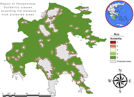
4.6.1 Distance from protected areas
UNHCR suggests that countries hosting refugee groups should take into account protected areas and site the refugee camps sufficient afar so that protected areas will not be affected by the refugee camp operation. Specifically, it refers to a walking distance of one day from the protected areas, corresponding to 50 kilometers (UNHCR, 2015). In this study, as protected areas were considered those designated as “Natura 2000 sites” and the areas included in the Common Databases on Designated Areas (CDDA).
Due to the large number of protected areas in the region of Peloponnese and the long distance of 50 kilometers as an exclusion zone, it was considered necessary not to designate a certain distance as unsuitable. For the subcriterion of the distance from protected areas, standardization is performed with a positive linear correlation and for this reason the class containing the highest value receives the higher score.
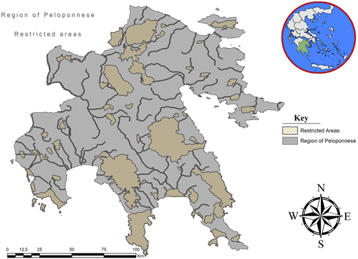
Moreover, rivers have been considered to be restricted areas since they cannot be built upon and a 200-m exclusion zone was considered as unsuitable for siting a refugee camp. Spatial data of all restricted areas (protected areas and rivers) are compiled and removed from the final candidate sites using the relevant tool in GIS environment.
Summarizing and based on the classifications mentioned in the previous, the respective data needed were collected as in Table 3, the corresponding scoring of all four criteria and subcriteria are presented and grouped in classes in Table 4 and the relevant thematic maps are presented in Figures 2–10
Primary data
| Data description | Data type | Data source |
|---|---|---|
| Digital elevation model | Raster | https://www.eea.europa.eu/data-and-maps/data/eu-dem |
| Callicrates regions | Vector | http://www.statistics.gr/documents/20181/1194366/perifereies.rar/39886ba8-6335-4199-b651-92fac372386b |
| Callicrates local units | Vector | http://www.statistics.gr/documents/20181/1194366/oikismoi_2011.rar/05cc0b6c-5b70-418b-b9fd-33cfe72f5d19 |
| Natura 2000 sites | Vector | http://land.copernicus.eu/local/natura/natura-2000-2012/view |
| Common Database on Designated Areas (CDDAs) | Vector | https://www.eea.europa.eu/data-and-maps/data/nationally-designated-areas-national-cdda-12/gis-data/cdda-shape-file |
| Points of interest (Police stations, Hospitals, Airports) | Vector | http://geodata.gov.gr/dataset/demosia-kteria |
| Major road network | Vector | http://www.esri.com/software/arcgis/arcgisonline (using tool of Arcg is 10.1) |
| Rivers | Vector | http://geodata.gov.gr/dataset/potamoi-hydroscope-gr/resource/36e66076-5836-42ab-a090-01d346f7bc5f |
Classification, ranking and standardization of criteria and subcriteria
| Level 1 Main criteria | Level 2 Subcriteria | Value ranges of each class | Score (xi) |
|---|---|---|---|
| 1. Topographic | 1.1 Slope | <2 % | 3 |
| 2–4% | 5 | ||
| 4–10% | 4 | ||
| 10–20% | 2 | ||
| >20% | 1 | ||
| 1.2 Elevation | <400 m | 5 | |
| 400–600 m | 4 | ||
| 600–800 m | 3 | ||
| 800–1,000 m | 2 | ||
| >1,000 m | 1 | ||
| 2. Operational | 2.1. Distance from the nearest hospitals or health centers | <1,000 m | 5 |
| 1,000–2000 m | 4 | ||
| 2,000–3,000 m | 3 | ||
| 3,000–4,000 m | 2 | ||
| 4,000–5,000 m | 1 | ||
| 2.2. Distance from the nearest police station | <2,000 m | 5 | |
| 2,000–4,000 m | 4 | ||
| 4,000–6,000 m | 3 | ||
| 6,000–8,000 m | 2 | ||
| 8,000–10,000 m | 1 | ||
| 2.3. Distance from the nearest airport | <13,000 m | 1 | |
| 13,000–30,000 m | 5 | ||
| 30,000–50,000 m | 4 | ||
| 50,000–80,000 m | 3 | ||
| 800,000–110,000 m | 2 | ||
| 2.4. Distance from the major road network | <200 m | 5 | |
| 300–400 m | 4 | ||
| 400–600 m | 3 | ||
| 600–800 m | 2 | ||
| 800–1,000 m | 1 | ||
| 3. Social | 3.1. Distance from the center of the city with population over 2,000 inhabitants | <3,000 m | 2 |
| 3,000–6,000 m | 5 | ||
| 6,000–9,000 m | 4 | ||
| 9,000–12,000 m | 3 | ||
| 12,000–15,000 m | 1 | ||
| 4. Spatial | 4.1. Distance from protected areas | <400 m | 1 |
| 400–600 m | 2 | ||
| 600–800 m | 3 | ||
| 600–1,000 m | 4 | ||
| >1000 m | 5 |
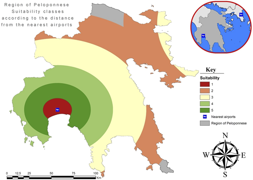
Suitability classes according to distance from the nearest airports with their corresponding values
Suitability classes according to distance from the nearest airports with their corresponding values
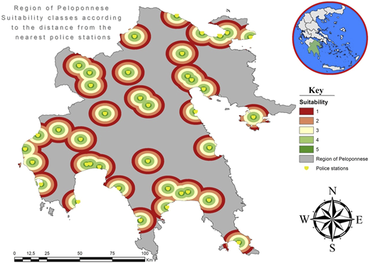
Suitability classes according to distance from the nearest police stations with their corresponding values
Suitability classes according to distance from the nearest police stations with their corresponding values
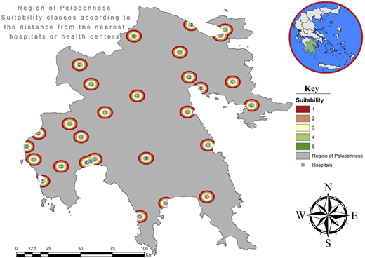
Suitability classes according to distance from the nearest hospitals or health centers with their corresponding values
Suitability classes according to distance from the nearest hospitals or health centers with their corresponding values
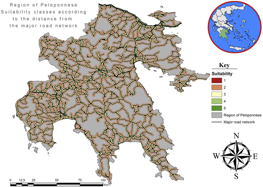
Suitability classes according to distance from the major road network with their corresponding values
Suitability classes according to distance from the major road network with their corresponding values
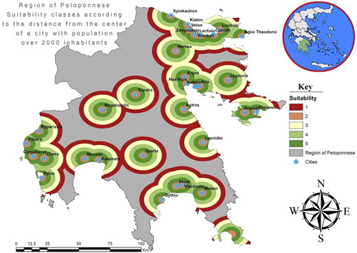
Suitability classes according to distance from the center of a city with population over 2,000 inhabitants with their corresponding values
Suitability classes according to distance from the center of a city with population over 2,000 inhabitants with their corresponding values
Suitability classes according to distance from protected areas with their corresponding values
Suitability classes according to distance from protected areas with their corresponding values
4.7 Step 2: Criteria weighting
4.7.1 Analytical hierarchy process (AHP)
The AHP method was used to weigh the criteria. The final coefficient weight for each factor is derived from the product of the weight of the basic criterion times the weight of the subcriterion as presented in Table 5.
Weights coefficients of criteria and subcriteria
| Level 1 Main criteria | Weight coefficient | Level 2 Subcriteria | Weight coefficient () | Weight coefficient w (w = ) |
|---|---|---|---|---|
| 1. Topographic | 0.29679 | 1.1 Slope | 0.875 | 0.260 |
| 1.2 Elevation | 0.125 | 0.037 | ||
| 2. Operational | 0.16641 | 2.1. Distance from the nearest hospitals or health centers | 0.45668 | 0.076 |
| 2.2. Distance from the nearest police station | 0.06289 | 0.010 | ||
| 2.3. Distance from the nearest airport | 0.33496 | 0.056 | ||
| 2.4. Distance from the major road network | 0.14547 | 0.024 | ||
| 3. Social | 0.46862 | 3.1. Distance from the center of the city with population over 2000 inhabitants | 1 | 0.469 |
| 4. Spatial | 0.06817 | 4.1. Distance from protected areas | 1 | 0.068 |
Based on this method and using the Super Decisions software, the criteria were compared pairwise allowing preference for the social criterion due to the type of the facility. At the same time, the topographic criterion is preferred next since it is directly related to the construction costs of facilities and weather conditions affecting refugees' living (Mong et al., 2014). The least preferred is the spatial criterion, since it was considered less important than the operational criterion.
Since the numeric values are derived from subjective preferences, some inconsistencies in the comparison matrix are unavoidable. The question is how much inconsistency is acceptable. For this purpose, AHP through Super Decision tool calculates a consistency ratio (CR) comparing the consistency index (CI) of the matrix in question (the one with the subjective preferences) vs the consistency index of a random-like matrix (RI). A random matrix is one where judgments are entered randomly and therefore it is expected to be highly inconsistent. The consistency ratio is defined as CR where CR = CI/RI. Saaty (1987) has shown that a consistency ratio (CR) of 0.10 or less is acceptable to continue the AHP analysis. If the consistency ratio is greater than 0.10, it is necessary to revise the judgments to locate the cause of the inconsistency and correct it. The consistency ratio for weighting the criteria is 0.022. The weights of the main criteria are presented in Table 5.
Then, a pairwise comparison of the subcriteria for each criterion was performed. The subcriterion of slope was clearly more important than elevation, as it relates both to construction costs and to the accumulation of stagnant water for refugee camps. The consistency ratio for weighting the subcriteria of the topographic criterion is 0.
The subcriterion of distance from the nearest hospital/health center was considered to be the most important of the operational subcriteria, as instant health care is the most important service offer to refugees after providing food, water and shelter. In this ranking, the next subcriterion is the distance from the nearest airport, as it is directly related to the operating costs of the facility and the transport costs. Less important than the previous is the subcriterion of the distance from the major road network, which relates to a part of the construction costs of the facilities in case of the need to construct a road or to extend the existing network. The least important among the subcriteria is the distance from the nearest police station, which contributes to reducing the cost of transporting security personnel and to the faster intervention of the police authorities. The consistency ratio for weighing the operational criterion is 0.041.
4.8 Step 3: Aggregation of weighted criteria
4.8.1 Weighted linear combination
As discussed in the methodology section, weighed linear combination (WLC) is used to combine the weighted criteria using a raster calculator in the GIS environment, and the scores of each cell for all thematic layers are summed according to the weight determined for each subcriterion. The sum of the scores is calculated for each cell of the raster model, which corresponds to the areas with intersected layers. The result from this summation is a new thematic layer of the raster model with cell scores from 1.23 to 4.758 (Figure 11).
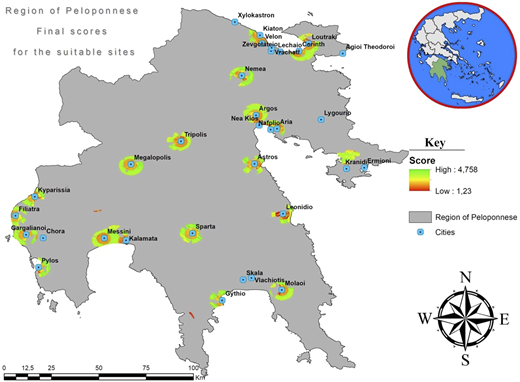
4.9 Step 4: Results
For exporting the quantitative results, the thematic layer rendered by the WLC is used with a score threshold of 4.7/5. This threshold was selected due to the fact that it was approximately the 99th percentile of the cells' scores. Based on this condition, 36 cells with a score of 4.7 and above were finally identified.
These cells were then converted into GIS polygons, in order to identify and remove the common spaces to the polygons of the restricted areas. This yields 15 polygons, which match the scores of the original cells, as presented in Table 6.
Candidate sites of Peloponnese region
| Candidate sites | Score | Size (sq. m.) | LNG | LAT | |
|---|---|---|---|---|---|
| 1 | Filiatra | 4.758 | 29.316 | 21.57762 | 37.12897 |
| 2 | Messini 1 | 4.718 | 29.325 | 22.06104 | 37.07263 |
| 3 | Messini 2 | 4.718 | 29.325 | 22.05887 | 37.0748 |
| 4 | Gargalianoi | 4.71 | 29.349 | 21.63179 | 37.0373 |
| 5 | Pylos 1 | 4.706 | 29.406 | 21.71721 | 36.88313 |
| 6 | Pylos 2 | 4.706 | 29.404 | 21.71512 | 36.8873 |
| 7 | Pylos 3 | 4.706 | 29.389 | 21.72346 | 36.92688 |
| 8 | Pylos 4 | 4.706 | 57.939 | 21.7309 | 36.92904 |
| 9 | Sparta 1 | 4.706 | 281.037 | 22.4531 | 37.0532 |
| 10 | Sparta 2 | 4.706 | 29.307 | 22.41729 | 37.1018 |
| 11 | Sparta 3 | 4.706 | 208.382 | 22.41215 | 37.10485 |
| 12 | Sparta 4 | 4.706 | 187.664 | 22.43718 | 37.10438 |
| 13 | Kyparissia 1 | 4.706 | 29.267 | 21.71096 | 37.24772 |
| 14 | Kyparissia 2 | 4.706 | 29.259 | 21.70262 | 37.26855 |
| 15 | Gythio | 4.702 | 58.013 | 22.57479 | 36.78323 |
Table 6 shows that the most suitable areas can be grouped according to the 7 nearest cities of more than 2,000 inhabitants (Filiatra, Messini, Gargalianoi, Pylos, Sparta, Kyparissia and Gythio) and classified according to their final overall score. At the same time, all of these sites are geographically defined according to their longitude and latitude. With respect to their size, all the final candidate sites are sufficient to site a refugee camp, since according to the Greek legislation the minimum area needed to establish a refugee camp is 15,000 square meters. It is worth noting that the area the Transit Site in Korinthos is located at is assigned a score of 3.089, quite lower compared to the first 15 ones in Table 6.
In order to depict the changes in the candidate sites pool and their scores caused by the inclusion of the social criterion, a similar analysis was conducted excluding it. The weights of the main criteria in this case are illustrated in Table 7.
Weights coefficients of criteria and subcriteria excluding the social criterion
| Level 1 | Weight coefficient | Level 2 | Weight coefficient | Weight coefficient w |
|---|---|---|---|---|
| Main criteria | (w1) | Subcriteria | (w2) | (w = w1*w2) |
| 1. Topographic | 0.58155 | 1.1. Slope | 0.87500 | 0.509 |
| 1.2. Elevation | 0.12500 | 0.073 | ||
| 2. Operational | 0.30900 | 2.1. Distance from the nearest hospitals or health centers | 0.45668 | 0.141 |
| 2.2. Distance from the nearest police station | 0.06289 | 0.019 | ||
| 2.3. Distance from the nearest airport | 0.33496 | 0.104 | ||
| 2.4. Distance from the major road network | 0.14547 | 0.045 | ||
| 3. Spatial | 0.10945 | 3.1. Distance from protected areas | 1.00000 | 0.109 |
The yielded cell scores had a minimum value of 1.142 and a maximum value of 4.896, a range somewhat broader than the one when the social criterion is included. Using the same score threshold of 4.7/5, 89 cells (almost 2.5 times more compared to the ones when the social criterion is included) were identified, yielding 38 polygons–most suitable areas (again almost 2.5 times more compared to the ones when the social criterion is included). These most suitable areas can be grouped according to the 9 nearest cities: Six are the same with the ones when the social criterion is included, namely Filiatra, Gargalianoi, Pylos, Sparta, Kyparissia and Gythio; Messini is excluded and three more are added, namely Astros, Ano Gliata and Anthoussa. Consequently, the inclusion of the social criterion drastically lessens/differentiates the size of the candidates' pool sites and the neighboring cities, thus effectively facilitating decision-making.
5. Summary and concluding remarks
Recent massive migratory and refugee flows, apart from the potential long-term positive effects on the world economy, may also have a negative impact on the host country, where the potential adoption of practices and policies implemented by other countries may not be as effective. Further, the massive entry of populations without legitimate documents tend to lead to the loss of a country's sovereign right to control its borders and check whether incoming people are a threat to the state (Adamson, 2006).
Decisions on locating facilities are crucial elements in strategic planning. MCDM provides a structured approach to fill any gap in the decision-making process as well as the tools to evaluate and prioritize multiple and, often, conflicting decision criteria as well as evaluating and ranking the alternatives.
In this paper, given the N.I.M.B.Y. phenomenon, a methodology for using GIS and MCDM in tandem to implement weighted criteria to identify suitable sites for siting a refugee camp through a Suitability Analysis is presented. The underlying motivation is to define and illustrate a flexible methodology that can support different policies and decision-maker preferences regarding the refugee camps siting problem.
5.1 Limitations
An important limitation is the lack of studies on measuring the level of desirability for refugee camps. Thus, the compromise of assuming all these facilities as semi-desirable was inevitable.
In this paper, the main criteria and subcriteria, their attributes and pairwise comparisons were determined according to existing literature and authors' informed judgment. However, it is noted that the identification and selection of the appropriate criteria is a complex, involute and time-consuming process that cannot be disregarded. This process involves the participation and cooperation of multiple experts on issues related to all criteria, such as civil engineers, topographers as well as local authorities, along with the policy decision-makers, which for siting refugee camps in Greece is the Ministry for Migration Policy. In addition, this process includes an on-the-spot study of the candidate sites by experts, which would take into account criteria such as availability and ownership status. As a whole, this implies that addressing the refugee camp siting problem is a laborious policy process involving multiple stakeholders in multiple levels and cannot be rushed in order to be truly effective. In this paper, the main criteria and subcriteria, their attributes were determined according to existing literature and authors' informed judgment.
5.2 Generalizability of the proposed methodology and its uses
The methodology presented is considered both useful and flexible. Even though it was used to identify suitable candidate areas for new sites, the method is just as applicable to re-assess existing refugee camps' locations, for example, for pinpointing sites that are unsuitable to the goal of hosting refugees. Further, the set of criteria and their thresholds can be adjusted accordingly to include more or fewer social criteria so that decisions takes reflect the interests of specific stakeholders or the society at large.
Duly said that, the authors do not support the view that that refugee camps are generally considered undesirable. The goal has been to illustrate that in the light of the N.I.M.B.Y. phenomenon, it is still possible to find suitable candidate areas for siting refugee camps. Speaking of it, reducing the N.I.M.B.Y. phenomenon is likely to require, foremost, a change in the way local societies perceive refugee camps. Moreover, it requires decision makers at any level taking into account local community opposition, whenever present, to ensure that camps are sited so as to minimize, rather than aggravate, the N.I.M.B.Y. phenomenon, a view soundly corroborated by the method applied in this study. It is useful to describe a trade-off relationship between what society and refugees want.
A policy implication, fully aligned with the utilized framework in this study, which has emerged from mid-August 2020, is that the Greek government decided to shut down all temporary facilities (hotels) for hosting refugees in mainland urban areas till the end of 2020. This is due to the fact that on one-hand there is an evident resentment from the local communities and on the other hand there seems to be an increasing understanding that refugee camps cannot be considered any more as short termed.
The proposed methodology can also be applied to create a “pool” of candidate sites for different types of facilities. A national or supranational data base can be created and combined with relevant assessments of public land and facilities. UNHCR could use a similar methodology for siting refugee camps in other countries. The criteria/subcriteria presented here could be adopted depending on the country or broader area policy applied in each case, the magnitude of the flows to be accommodated and the existing hosting infrastructure. For example, the sizes of camps in the Middle East or Africa hosting tens of thousands of refugees are not applicable in any European country.
Finally, given the flexibility of software tools, it is much easier to perform a “what if analysis” allowing decision-makers and analysts alike to review different contingencies within a short span of time, for example, in the case of an emergency.
Professor Nikitas-Spiros Koutsoukis and Professor Efstathios T. Fakiolas are members of “Political Technology” Research Group, Department of Political Science and International Relations, School of Social and Political Science, University of Peloponnese, Greece.
